Download Agreement, Release, and Acknowledgement of Risk:
You (the person requesting this file download) fully understand mountain climbing ("Activity") involves risks and dangers of serious bodily injury, including permanent disability, paralysis, and death ("Risks") and you fully accept and assume all such risks and all responsibility for losses, costs, and damages you incur as a result of your participation in this Activity.
You acknowledge that information in the file you have chosen to download may not be accurate and may contain errors. You agree to assume all risks when using this information and agree to release and discharge 14ers.com, 14ers Inc. and the author(s) of such information (collectively, the "Released Parties").
You hereby discharge the Released Parties from all damages, actions, claims and liabilities of any nature, specifically including, but not limited to, damages, actions, claims and liabilities arising from or related to the negligence of the Released Parties. You further agree to indemnify, hold harmless and defend 14ers.com, 14ers Inc. and each of the other Released Parties from and against any loss, damage, liability and expense, including costs and attorney fees, incurred by 14ers.com, 14ers Inc. or any of the other Released Parties as a result of you using information provided on the 14ers.com or 14ers Inc. websites.
You have read this agreement, fully understand its terms and intend it to be a complete and unconditional release of all liability to the greatest extent allowed by law and agree that if any portion of this agreement is held to be invalid the balance, notwithstanding, shall continue in full force and effect.
By clicking "OK" you agree to these terms. If you DO NOT agree, click "Cancel"...
It's been a few years since I've been actively 13ering in the San Juans. La Garitas almost don't count. I wanted to get down to Telluride and started poking through trip reports from the usual suspects, and this group came up with TR's from Furthermore, ChicagoTransplant and Kevin Baker. These should be an easy loop. Photos looked pretty mellow. Kind of like a Sawatch ridge run in the loose scree talus field of the nasty San Miguel range. Should be a good re-intro!
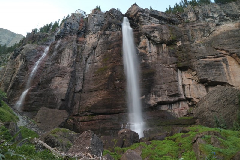
After camping near the Silver Pick TH for Wilson Peak, I headed into Telluride just after dawn. Good weather today, so I figured it would be a good way to drive my first real 4x4 road in 3 years and see the falls in daylight before the hordes of tourists. As I got off the pavement and got closer, I was half tempted to park the truck all the way at the bottom. But I thought that would be laughable, so I decided to drive to the falls at least. When I got there and took a series of photos, the road wasn't bad at all. Tight switchbacks, but the road was reasonably wide enough to travel, that going downhill shouldn't be too bad. After another argument with myself, I continue driving up. Nothing bad at all! That was until I got to the end of the road. Or at least was confronted with the one-way coming down from Black Bear Pass. There wasn't much of a turn around. Just a super tight switchback coming down from the upper pass and a gate. I got out and I knew my truck could go perpendicular to turn around, but I just wasn't feeling it. I kept envisioning careening down the slope in my truck, all the way to the base of the waterfall. Let's just go do the hike and deal with this later!
Bridal Veil Falls
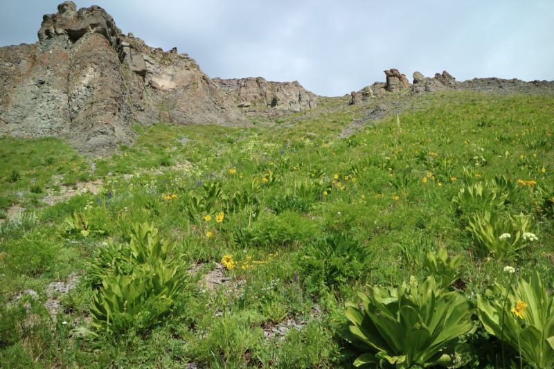
So off I go, through the gate above the waterfall and up another 4x4 road. I had originally thought to follow Furthermore's route up Jackass drainage, but when I came to a nice stream crossing and the promise of a locals trail up to Silver Lake Basin, I was sold. Definitely a locals trail, but reasonably easy to follow and not bad overall. Assaulted by flowers almost taller than me, but that's all good, when there's a trail! Pretty steep until you get into the main part of the basin below the lake, but then it was pretty fast till I was starting the contour around the lake.
Shadow and Light Ballard and falls
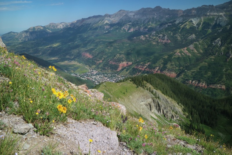
Once at Silver Lake, I debated on my route. I didn't really need to summit an unranked 12er Ballard, but contouring for miles to then reach the saddle also didn't look appealing. So after plenty of debate, I decided the 100' extra for Ballard would be worth the effort and non contour for miles aspect. Turns out there was even a bit of a switchback trail up as well (as can be seen from Jackass). Steep and a bit loose, though the flowers helped hold the slope in place. Even got a nice view down into Telluride on the way up.
Jackass and Ballard Approaching Ballard
Jackass and flowers
Slope up Ballard
Glider!
Looking down on Telluride
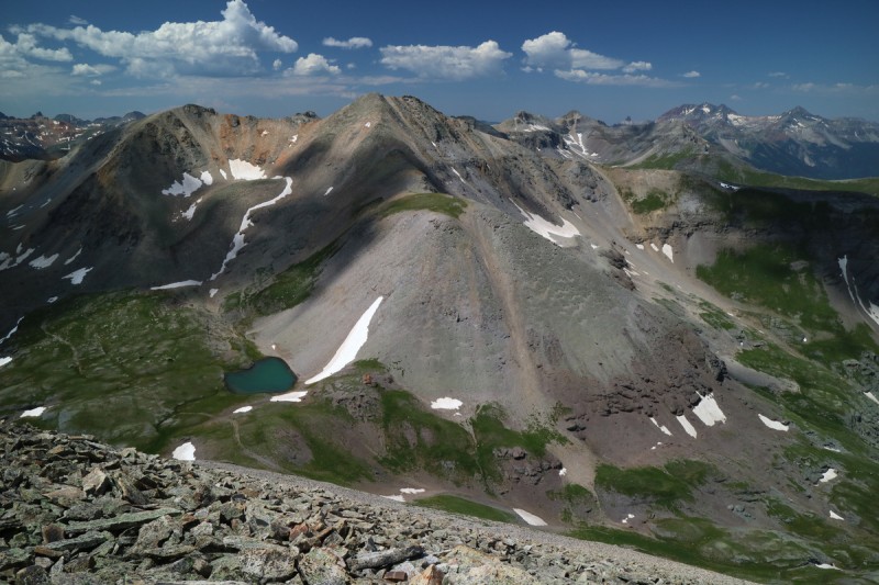
Once on Ballard came the next route decision. To the left or right of the cliffs on Jackass? Left looked nasty, and I couldn't even see a game trail, so it must be right. Once on the right, I could even see a faint climbers/locals trail that skirted the difficulties. A minor bit of scrambling (2+) on loose rock (non exposed) and I was on the summit.
Great views all around. Weather was turning out to be pretty good as forecasted. Could even clearly see the bypass on La Junta mentioned in the other TR's. So after a short break, I retraced my steps back a bit, and started over to La Junta. Looking back, there seems to be a trail directly off the summit too. But I figured I would go with the known, as it didn't cost me all that much.
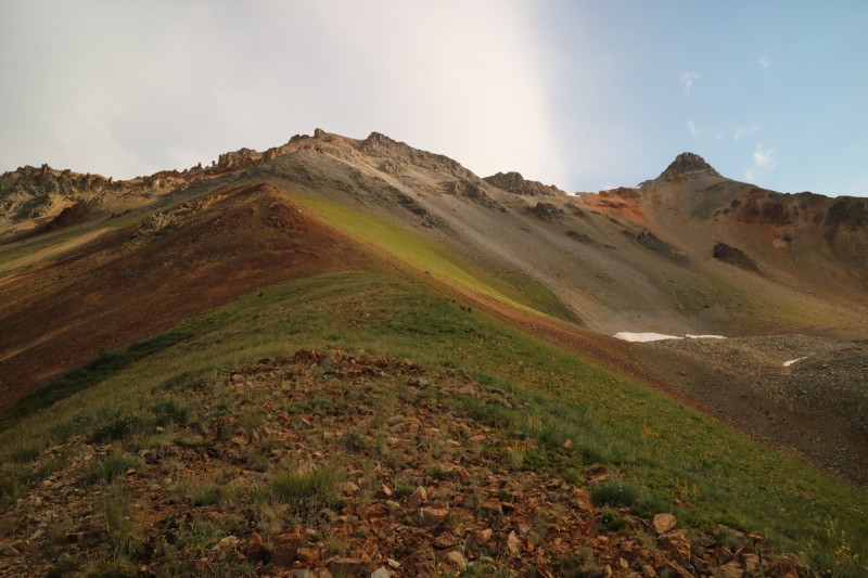
Slope over to Jackass Looking back on Ballard Pano north of Sneffels, Dallas and group Pano North Almost trail up La Junta Wasatch Mtn Almost trail up Ballard
La Junta and Wasatch
Looking back on Jackass
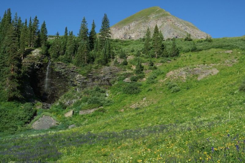
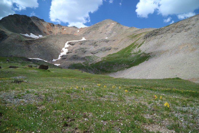
It didn't take long before I was on the summit of La Junta. The way down looked rather steep, but there was also a clear usage trail on it. Scree - wee! Glad I was going down this section! From there I could see the way ChicagoTransplant went up a grassy ramp to Wasatch Mtn. Much prefferable I thought, than going up a talus ridge. Prettier too!
Wasatch from La Junta
Grassy ramp up Wasatch Mtn Route down La Junta
The summit truly is the very edge of the ridge! Nice to not have any false summits and to visually see the end point! I wanted to stay longer, but it appeared that some rain may be moving my way, so back down I went. At least there was 4x4 roads or trails most of the way back too! I did have to leave the Telluride to Ophir trail to get to another road/trail down to the Falls, but that was a short section. It was even cairned... which was rather pointless, but oh well!
View of peaks today Preview of tomorrow Flower wonderland View of La Junta from road/trail
After leaving the flowering beauty of the upper meadows, it was very much a long 4x4 road walk out. Met plenty of falls tourists who decided to extend their hike by continuing up the road. More and more the closer I got to the vehicles.
Once back at the truck, I noted that a SUV had blocked a possible turn around strategy. Hmmm now what? So I make an off hand comment to a friendly local (Greg, I believe) about me being apprehensive about turning my truck around. He quickly offered to do it for me, after hearing it was a stick and understanding that I haven't driven it all that much in 3 years. Not ashamed one bit. Just like being away from class 3-5 has hurt my mental scramble game, so had not off-roading. It'll come back with time. I just really really hate exposure in my truck, and this situation flared my fear response. The rest of the drive down wasn't bad at all, since it was later in the afternoon, and most people were heading downhill anyway. Plenty of width and many pullouts too.
After a brief pause in Telluride to check weather, which had deteriorated, I was off to Ophir. I was planning on hiking V3 the next day, even though the route Furthermore describes didn't sound "fun". I had to use my GPS to find the road turn off. After my experience driving 4x4 roads today, I decided to stop at the turn off. The giant mud puddle at the start was also off putting. Great view of my project peak, South Lookout Peak, and of US Grant & V3 from my campsite.
South Lookout Peak
Pink South Lookout Peak
After a shorter nights rest than I would have liked, thanks to a good book, I awoke to the pitter patter of rain on my topper. Dang... Not what I want! Tough to motivate. So I hit snooze on the alarm, repeatedly. Should I just pack it in and drive home? Hmmm. Lets have some coffee and see if those gloomy clouds to the west improve any.
So I drink my cold brew coffee and stare up at South Lookout Peak. From just about any angle, it looks incredibly intimidating. My usual camp spot on the Silverton side also looks as insane. Eventually I will look up the YDS and maybe a TR or two to see a route, but for now, I'm enjoying just pondering a way up it!
US Grant
South Lookout zoom
US Grant and V3
After the coffee, I start to think that attempting V3 may be in vain. High likelihood of rain, and the end of the route to the summit is sucktastic scree according to Furthermore. If he takes note, it must be really really bad! So now what? I had only briefly looked at the peaks to my immediate north, Silver Mtn and San Joaquin Ridge. At least those have zero approach. All uphill from the start, but I would at least have a reasonable chance of summitting 1 of them in time. No cell service at the campsite, so I check my GPS and head north!
After a quick bushwack, I find the mining road that I would take off an on up the nice wooded and grassy slope. The middle section is quite abandoned and over grown, but the upper part is wide and nice. When the slope in between is easy, I take that, versus wasting time on the longer switchbacks.
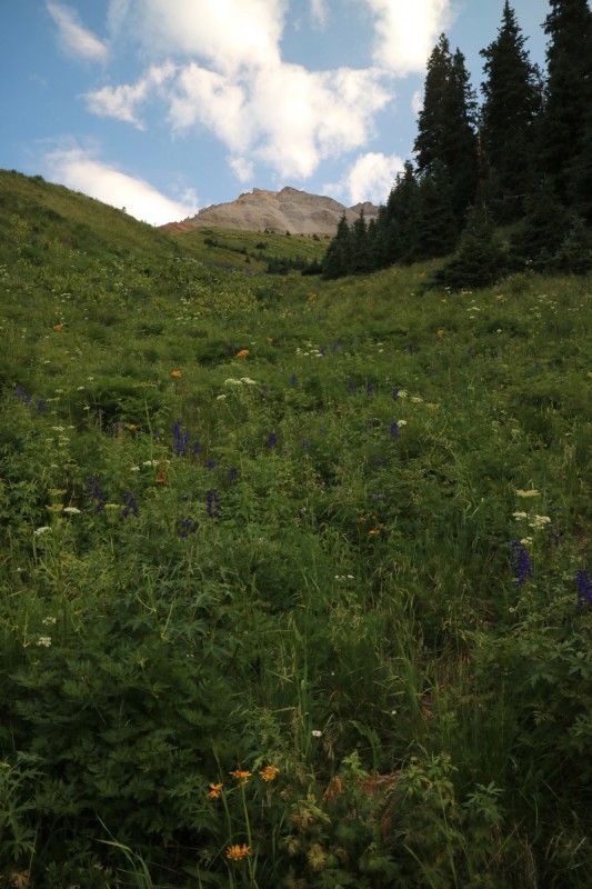
Slope up to San Joaquin Ridge Flowery slope Mining road up Flowers and mining
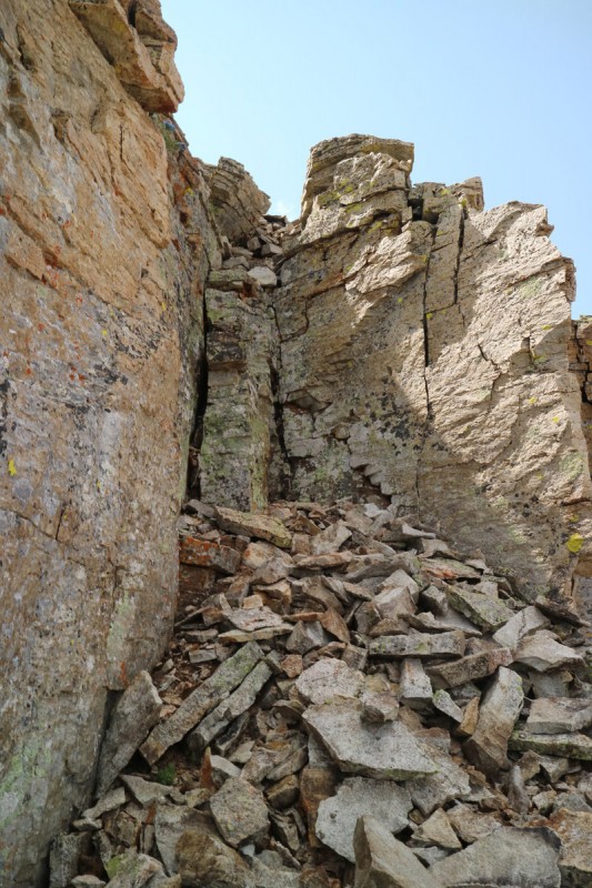
When I get to an easy access point to the ridge up what I think is the summit (labeled on the map as summit), I head up the nice grassy slope to the ridge. I follow ridge proper, even over a section of nasty steep scree talus. If you go just to the west or left of the big talus slope, you can follow grass all the way up to the worst of the ridge/slope. At that point, the route gets rough. Welcome back to San Juan steep loose class 2+/3 talus! The last couple hundred feet took a very long time to complete. Lots of time trying to figure out a way that the talus wouldn't start a small rock avalanche and break my leg. I wasn't worried about a total mass wasting event, but even a small slide could really hurt someone.
I make it around to the left of the towers on a reasonably stable slope. But ended up hugging to the right side to utilize the more solid rock to try and pull myself over the precariously piled rocks. Every step I was envisioning a rock slide taking out my tibia. Above that section, I thought I was home free. Just one more obstruction till the summit. Not exactly. The slope angle does not relent. I went to the right, and found myself on loose scree and friable bedrock. Probably should have gone to the left, but it could have sucked just as badly! Eventually I made the top, and immediately realized it was not the true summit, that was off to the east.
I know I'm a bit sensitive to the leg break scenario right now, but yeah - I don't recommend this route!!!
Ridge up to false summit
Silver Mtn and Wilson Group
Talus towers of doom Shitty slope of moving talus Still more shitty sliding talus to go
On the falsey, I decide that the way over to Silver just isn't in the cards today with the storms. Plus, beyond the true summit of San Joaquin and Oscars, is an actual trail! The call of the trail wins out, and I write off Silver Mountain for another easy day. Sign the register, which makes me laugh, since it's not the true summit, and everyone knows that.
On the way over to the true summit, I get treated to finding some pretty sparkly garnet crystals! Yay!
The final summit push could likely be kept ol class 2+, but I go for a nice dihedral to climb up. More scramble fun, no exposure. My kind of route.
San Joaquin from false summit
Wasatch Mtn from yesterday
Silver Mtn Ice Lakes Basin 13ers
Consensus that this isn't the summit...
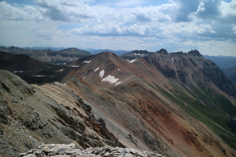
Ridge up to San Joaquin
Garnets!!!
My dyhedral of choice
Once on the real summit, the storms to the south over Ice Lakes Basin and the Weminuche start to look pretty nasty. I'm in little danger where I am, at least for now, but it's best to get down in case that all changes. The first part of the descent was a bit interesting, but then it got as simple as can be, all the way up to Oscars Peak.
Summit ridge View over to Oscars Peak Look back on false summit
Short stop on the unranked 13er before heading down to the super steep trail. Runners must take this a lot between Telluride and Ophir! Plenty of steep scree had me almost hit my tail bone a few times. But it was a fast way down to the road. Even with the storm clouds so incredibly close, I spent 90% of my day in the hot sunshine.
Look back on San Joaquin Ridge
Wasatch Mtn in the light
Lookout Peak looking stormy!
North side of San Joaquin Ridge
The start of the trail... not hard to find at all...
If I had moved my truck to the start of the road I took uphill, it would have been only 0.04mi from where I exited on the road on the way down. Nothing is really marked, and the roads a quite different than those you find on TOPO! Fun!
Overall, not a bad re-introduction to the choss boss San Juans. Maybe next time I'll read those TR's a little bit closer, till I get back into my 13er groove!
My GPS Tracks on Google Maps (made from a .GPX file upload):
Glad the TR was useful. Those are some great flower pics! I think we did the exact same route on San Joaquin last year, we all kind of split up on the crappy talus to keep out of each others' firing ranges. That descent trail was marked for the Hardrock when we were there, it probably would have been better if we just did an out-and-back from that route but live and learn in the jungles of San Juan scree :lol:
and wildflower shots! I am a bit surprised you hiked San Joaquin as it's a skiable peak (on my "drool" list). :) Also thanks for reminding me about South Lookout! I was about to tag it in ski boots in 30 min while Brittany waited for corn to ripen, but quickly realized something was off. :lol: Later had a field day reading all the TRs I could find. I'll be better prepared next time!
Jvinro - Thanks, tough to take a bad photo down there!
Bill & Jay - There were soooo many flowers!
XterraRob & jeffth5 - With 2 summers off 13ering, I've focused on photography. Trying to do my pro grandpa proud!
ChicagoT - Your TR made sure I didn't hustle down too quickly. No need to fight the vehicles going all over that road! Even just using that trail for the up and over to Silver would be better than that slope! It started off nicely though.
Doug - I really need to go through my photos from our trip to the IPW, I think I may have a few good ones too :D
Nat - Considering the true summit os San Joaquin isn't where it's marked on the map, I doubt that skiable slot is anywhere near the true summit. Of course, hiking a peak in summer never precludes me from skiing it! Since I hadn't been to Ophir yet, getting a feel for the ski possibilities was worth it! Haha - quickly tag SLP! That is a truly drool worthy peak!
LIV - When you drive 6.5 hours, it's business time! Have to get the body and mind back in shape after the injury hiatus!
Caution: The information contained in this report may not be accurate and should not be the only resource used in preparation for your climb. Failure to have the necessary experience, physical conditioning, supplies or equipment can result in injury or death. 14ers.com and the author(s) of this report provide no warranties, either express or implied, that the information provided is accurate or reliable. By using the information provided, you agree to indemnify and hold harmless 14ers.com and the report author(s) with respect to any claims and demands against them, including any attorney fees and expenses. Please read the 14ers.com Safety and Disclaimer pages for more information.
Please respect private property: 14ers.com supports the rights of private landowners to determine how and by whom their land will be used. In Colorado, it is your responsibility to determine if land is private and to obtain the appropriate permission before entering the property.


 Bridal Veil Falls")
 Shadow and Light")
 Ballard and falls")
 Jackass and Ballard")
 Approaching Ballard")
 Slope up Ballard")
 Looking down on Telluride")
 Slope over to Jackass")
 Looking back on Ballard")
 Pano north of Sneffels, Dallas and group")
 Pano North")
 Almost trail up La Junta")
 Wasatch Mtn")
 Almost trail up Ballard")
 Looking back on Jackass")
 Wasatch from La Junta")
 Grassy ramp up Wasatch Mtn")
 Route down La Junta")
 View of peaks today")
 Preview of tomorrow")
 Flower wonderland")
 View of La Junta from road/trail")
 Slope up to San Joaquin Ridge")
 Flowery slope")
 Mining road up")
 Flowers and mining")
 Ridge up to false summit")
 Talus towers of doom")
 Shitty slope of moving talus")
 Still more shitty sliding talus to go")
 San Joaquin from false summit")
 Silver Mtn")
 Ice Lakes Basin 13ers")
 Ridge up to San Joaquin")
 My dyhedral of choice")
 Summit ridge")
 View over to Oscars Peak")
 Look back on false summit")
 Look back on San Joaquin Ridge")
 Lookout Peak looking stormy!")