Download Agreement, Release, and Acknowledgement of Risk:
You (the person requesting this file download) fully understand mountain climbing ("Activity") involves risks and dangers of serious bodily injury, including permanent disability, paralysis, and death ("Risks") and you fully accept and assume all such risks and all responsibility for losses, costs, and damages you incur as a result of your participation in this Activity.
You acknowledge that information in the file you have chosen to download may not be accurate and may contain errors. You agree to assume all risks when using this information and agree to release and discharge 14ers.com, 14ers Inc. and the author(s) of such information (collectively, the "Released Parties").
You hereby discharge the Released Parties from all damages, actions, claims and liabilities of any nature, specifically including, but not limited to, damages, actions, claims and liabilities arising from or related to the negligence of the Released Parties. You further agree to indemnify, hold harmless and defend 14ers.com, 14ers Inc. and each of the other Released Parties from and against any loss, damage, liability and expense, including costs and attorney fees, incurred by 14ers.com, 14ers Inc. or any of the other Released Parties as a result of you using information provided on the 14ers.com or 14ers Inc. websites.
You have read this agreement, fully understand its terms and intend it to be a complete and unconditional release of all liability to the greatest extent allowed by law and agree that if any portion of this agreement is held to be invalid the balance, notwithstanding, shall continue in full force and effect.
By clicking "OK" you agree to these terms. If you DO NOT agree, click "Cancel"...
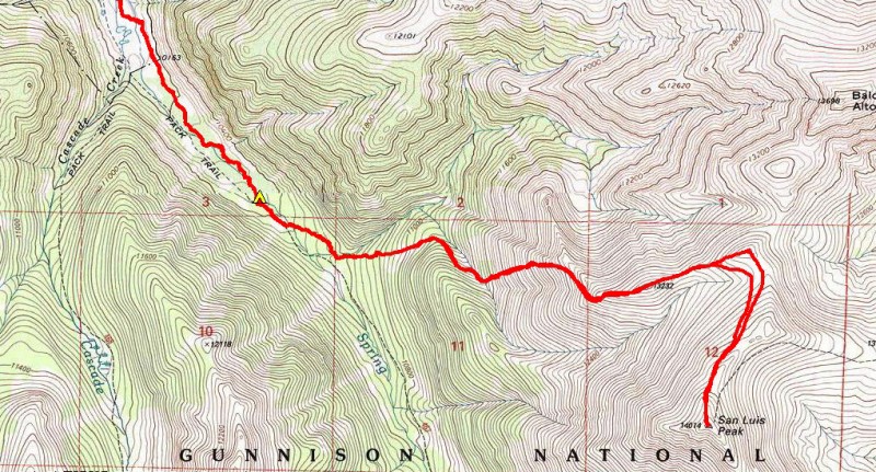
N Ridge via Spring Creek RT Stats: 21.5 mi, 5500 ft
Start: FS Rd 788 (1.25 mi SE of Cathedral)
Jan 15-17, 2016
Anyone who has met Dominic knows he is not a list person. Quite the opposite. Frankly when he told me he wanted to finish off his 7 remaining winter 14ers this year I was shocked! Most of them (Redcloud, Sunshine, Shavano, Tabeguache, Princeton and Pikes) are shoe-ins and can be climbed in almost any condition. San Luis, given its remoteness and avalanche concerns, is the only one that might require some finesse.
Only in very recent years has a standard winter route for San Luis emerged. It begins north of Creede at the Equity Mine, climbs toward San Luis Pass, and then drops into the head of the Spring Creek drainage to access the west and south sides of San Luis. Several variations exist and the most appropriate option is condition dependent. Usually it is wise to lose considerable elevation in Spring Creek in order to mitigate avalanche risk. Five years ago a large group of us pulled this route off as an 11 hour daytrip in fairly cooperative early spring-like snow conditions. I shudder to think about how much longer it could potentially take in deep unconsolidated powder. And the fact that this route loses considerable elevation on the approach detracts from its appeal as an overnight trip.
More than a decade ago Ken Nolan made two winter ascents of San Luis via long, multi-day treks up Spring Creek from the north. This route is longer and requires more overall effort, but we'd prefer an overnight trip to an epic long day with a non-zero chance of failure. It seems worth a try. Besides, Dom is a big fan of winter backpacking and this is the perfect excuse.
Disclaimer: The only access to the mouth of Spring Creek is via private property. You must hike through a large, active cattle ranch to access the Bondholder Trail that leads up Spring Creek. We obtained the landowner's permission to do this.
Friday
To avoid parking on private property we begin walking from a small plowed pullout 1/3 mile from the start of the ranch road. On our stroll through the farm we watch a baby cow run full speed into a fence! Odd.
Reality sets in quickly when we reach the far side of the ranch and the end of the packed snow. Instantly we're wallowing in knee deep sugary powder. Oh boy, we're in for an ass-kickin'! Over the course of the next 7 hours we struggle to cover a single mile per hour. Fortunately there is a lot of game activity in this area; deer postholes are obnoxious to snowshoe through but this requires slightly less effort than pioneering a new path through the otherwise pristine and seemingly bottomless powder.
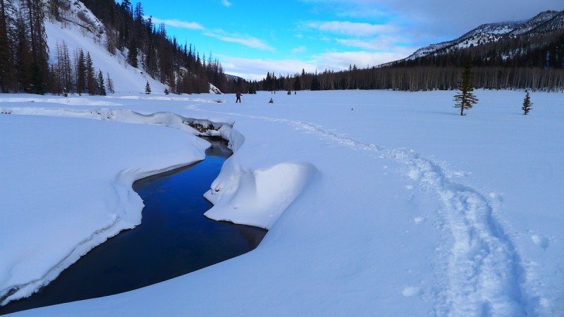
Crossing Spring Creek in Bondholder Meadows
It commences snowing around noon. Past the endless Bondholder Meadows the going gets tougher. Deadfall, yay. Our pace slows considerably and we're starting to lose steam. Judging by the few remaining meandering tracks and the abundance of places where the deer have lounged, its clear they'd had enough at this point too. At 10,350 feet and after 4pm we call it good and erect camp in the continuing snow shower.
Saturday
Its still snowing lightly when we resume the trailreaking torture up Spring Creek around 7:30am the next morning. After a long half mile we turn left and head due east up a narrow side drainage, staying a bit off the messy looking floor on mostly gentle slopes on the south side. There are a couple of short sections that would be questionable during periods of higher avy concern. Thankfully today the snow is stable, wallowy yes, but at least we're confident in it staying put.
The fun factor increases when we veer right up another narrow side drainage, again staying off the floor which is situated under suspect slopes. We're on the heavily treed other side, traversing steep northeast facing slopes. I find it particularly exasperating when I can no longer swing my leg up over the top of the snow and have to resort to the plow method.
Its cold as hell; I have to stop and put on my big mitts despite all the hard labor. Who's idea was this again? At least the snow has stopped and the skies are clearing.
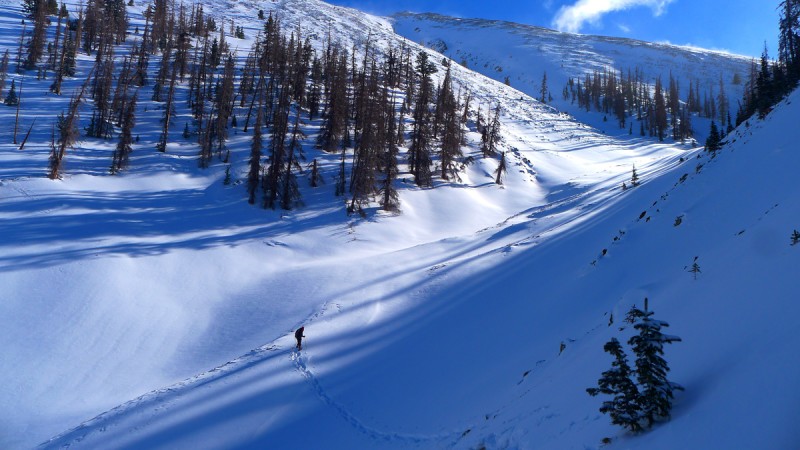
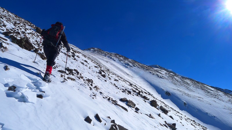
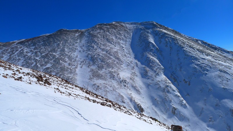
At long last a safe line up the west slopes of Point 13,232 presents itself and our spirits are lifted. We find a place to drop the short distance to the bottom of the drainage, cross to the other side, cache our snowshoes, and climb 1300 feet of annoyingly loose and snow covered talus and scree to the west ridge of Point 13,232. San Luis isn't giving himself up easily.
Grungy west slopes of Point 13,232 Looking further up Spring Creek to where the standard route drops in
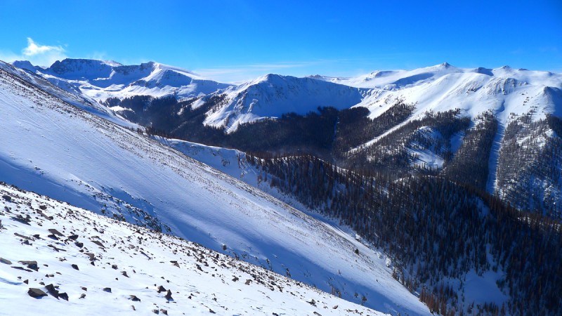
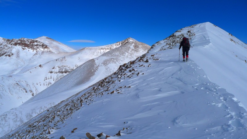
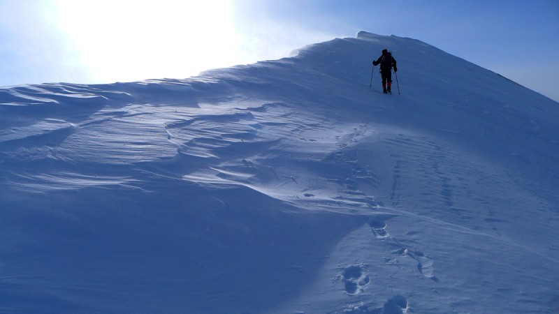
Continuing east over Point 13,232 along a snowy and corniced ridge, the summit of San Luis finally comes into view. It's tantalizingly close but the ridge we're on takes its time getting there.
San Luis' northwest slopes Nearing Point 13,232 with Stewart and Baldy Alto on the left
We battle a new adversary on the final 700 foot push: that iconic Colorado winter wind. A steady gale blows, knocking us around more and more the higher we climb, draining both our strength and core temperature.
Our summit break consists of plopping down for 60 seconds and then agreeing to get the hell out of here.
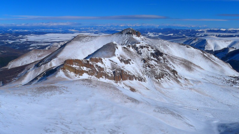
Organ Mountain to the east
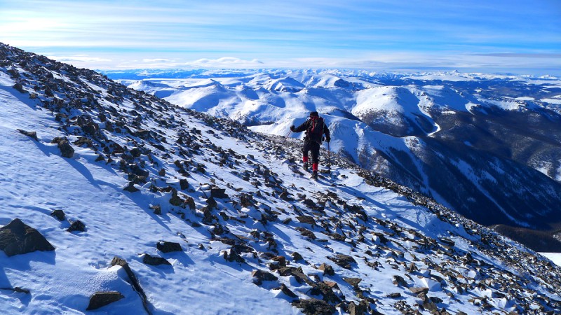
I have to admit, I'd had high aspirations of climbing a thirteener on this trip as well. As we descend San Luis and escape the worst of the wind my mind turns to a quick trip over to Baldy Alto. I was really hoping for Stewart Peak but this will be a good consolation prize. As we continue on the wind returns in full force and I concede defeat. It's already past 2pm and we are both having trouble staying warm even while moving; we're starving but don't want to stop.
Stewart Peak & Baldy Alto
We plod back up Point 13,232 and then emit an abundance of profanities as we descend the loose slope back to our snowshoes.
Looking straight down into Stewart Creek toward Organ Mountain Retracing our steps over Point 13,232 Corniced ridge on Point 12,232
It has clouded up once again and the next wave of snow begins to fall as we cruise our trench back to camp. Sunday
It's still snowing when we pack up camp and begin the 7.5 mile hike out Sunday morning. A total of about four inches have fallen on our track, and as feared it is completely blown in through Bondholder Meadows. We've certainly gotten our money's worth on this one.
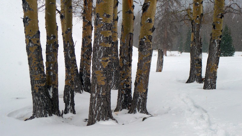
Cool stand of trees on the south end of Bondholder MeadowsUnsettled weather over upper Spring CreekBreaking a new track back across Bondholder Meadows
Route to summit
After taking care of Shavano and Tabeguache Dom hopes to soon be celebrating atop Pikes Peak. It'll be his 14er finisher
and winter 14er finisher all rolled into one.
Thumbnails for uploaded photos (click to open slideshow):
A little snow is no match for the Dominator. We may have a couple as 5th & 6th or whatever the number is, unless I get busy. :D not likely. and then there is that Dad Mike guy. The storms are in Dominic's favor, and he has the best support crew. :wink:
Can't call myself a winter climber, but this report really paints the picture of how the winter elements can affect a climb. Great job and thanks for sharing.
Great report Sarah. Love seeing new, creative winter routes. And I'm not getting in the middle of this power couple. Don't worry, I won't be finishing any time soon.
Congrats on the climb! You mentioned getting permission from the landowner to cross their territory...can you elaborate on how you were able to do that? I'm scheming a San Luis expedition myself, and had actually looked at access from the north right before you put up this TR, so this is very intriguing! I'd probably continue up the Spring Creek drainage to eventually join with the SE ridge route, as this should be more amenable to a ski ascent/descent.
Personally, I am not so secretly hoping for an 11 hr RT myself in the winter-spring, so this report leaves me speechless. But I guess that's how one earns/cements her or his spot in the mountaineering history of Colorado. Way to be you two, and I am honored to have met you.
At first I was wondering why you were repeating San Luis of all peaks, then I read the report and it makes a lot more sense. Very cool you guys will both be finishers soon!
Great report and pictures too. Brings back a few memories :P
Congrats on reaching another tough winter summit, way to go! Wow, stunning and beautiful pictures. Thanks for posting. Especially love the Corniced Ridge and Bondholder Meadows!
Nice to hear from some old friends 1/22/2016 9:11am
dsunwall & Dad Mike - Fingers crossed that the weather starts cooperating so you guys can finish. You're so close!
Summit Lounger - Yes! Crown will be perfect for the occasion :D
AlexeyD - We simply knocked on the door and spoke with the landowner face to face. Sort of risky as the long drive would have been wasted if they'd said no. Luckily they turned out to be refreshingly friendly. I thought about trying to get their phone number on the way out but they weren't around.
SnowAlien - Yes, I highly recommend a spring ascent via the more standard route! And I am honored to have met you too :wink:
benners - Ya, I was less than thrilled about having to repeat this one! But it did bring back good memories of my first trip with you guys... which proved skiers and snowshoers can indeed coexist!
maverick_manley - Nice to hear from ya and see you're still out there getting after it as well!
Breaking trail on the way out is such a treat! Congrats. Only one more to go for Dom! Very cool.
Caution: The information contained in this report may not be accurate and should not be the only resource used in preparation for your climb. Failure to have the necessary experience, physical conditioning, supplies or equipment can result in injury or death. 14ers.com and the author(s) of this report provide no warranties, either express or implied, that the information provided is accurate or reliable. By using the information provided, you agree to indemnify and hold harmless 14ers.com and the report author(s) with respect to any claims and demands against them, including any attorney fees and expenses. Please read the 14ers.com Safety and Disclaimer pages for more information.
Please respect private property: 14ers.com supports the rights of private landowners to determine how and by whom their land will be used. In Colorado, it is your responsibility to determine if land is private and to obtain the appropriate permission before entering the property.

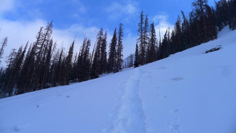


 Crossing Spring Creek in Bondholder Meadows")
")
")
 Grungy west slopes of Point 13,232")
 Looking further up Spring Creek to where the standard route drops in")
 San Luis' northwest slopes")
 Nearing Point 13,232 with Stewart and Baldy Alto on the left")
")
 Stewart Peak & Baldy Alto")
")
 Organ Mountain to the east")
")
 Looking straight down into Stewart Creek toward Organ Mountain")
 Retracing our steps over Point 13,232")
 Corniced ridge on Point 12,232")
 Cool stand of trees on the south end of Bondholder Meadows")
 Unsettled weather over upper Spring Creek")
 Breaking a new track back across Bondholder Meadows")
 Route to summit")


