
| Report Type | Full |
| Peak(s) |
Mt. Guyot - 13,372 feet |
| Date Posted | 12/19/2013 |
| Modified | 12/26/2013 |
| Date Climbed | 05/30/2008 |
| Author | moneymike |
| A blast from the past |
|---|
|
I found a bit of free time today and decided to tell you a tale...a tale about a young adventurous skier. The story begins long, long, ago. Long before Moneymike had even earned the name Moneymike and was still just known as "Somewhat Ok Mike" by his skier friends. The year was 2008. This was a great time for Somewhat Ok Mike, back when his knees were perfect and life for him consisted entirely of skiing, climbing, and drinking. This was a time when facebook was only used by thirteen year-old girls, and the young folk still listened to good music (and not butchered techno versions of "teen spirit," as they do today). Aaaaaaaaaahhhhhhhhh, the good old days! The story properly begins in early April of 2008. The hero of our story, Somewhat Ok Mike, went on a backcountry ski trip with a couple of his buddies from the Backcountry Club at CU Boulder. Their goal was to climb and ski Bald Mountain in Summit county. Although this was a relatively uneventful ski trip, Somewhat Ok Mike caught a view of a nearby peak that inspired a journey...a journey that would inevitably change Somewhat Ok Mike's name forever.  At the summit of Bald Mountain, Somewhat Ok Mike caught a glimpse of the snowy south face of Mt. Guyot. "F#@% my @&&!" Somewhat Ok Mike exclaimed with excitement! Actually, Somewhat Ok Mike hadn't yet seen the episode of South Park where Cartman shouts "F#@% my @&&!" so it's not likely that Somewhat Ok Mike used that exact expression, but it was probably something similar to that. 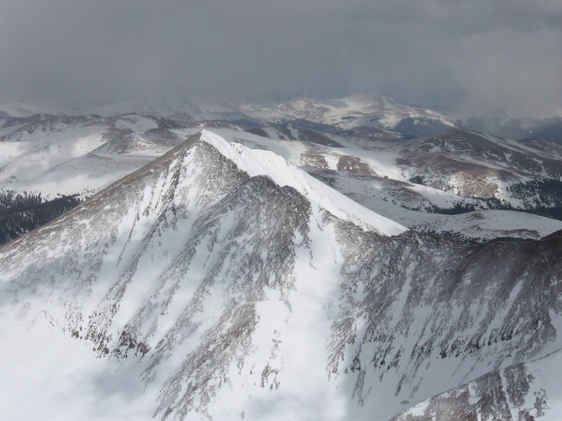 Somewhat Ok Mike was enthralled and inspired by the view he had seen. He knew he had to ski it! The next day, Somewhat Ok Mike sent an email out to the Backcountry Club looking for ski partners to ski Guyot's south face. Unfortunately, the only response he received was a beta shot request from Matt Primomo who originally had hopes of getting a first descent of that face. Matt promised Somewhat Ok Mike two beers for the beta shots. With the promise of free beer, Somewhat Ok Mike's journey was immediately upgraded to the status of "destiny." Somewhat Ok Mike's plan was to climb to the summit via the northwest face from French Gulch and scout the line from there. This decision was made due to the easy access...and I suppose a lack of internet researching skills could also be attributed to this decision. If the line looked good from the summit, the plan would then be to ski the line and then traverse around the mountain to the east. On April 21, 2008, Somewhat Ok Mike climbed Guyot's NW face according to the plan.  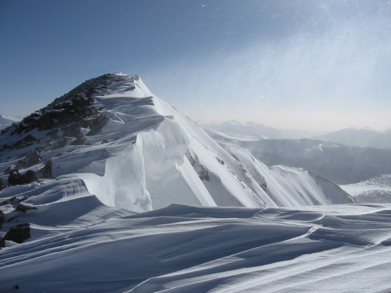 Peering over the edge, Somewhat Ok Mike was not able to get a view of the entire line. Deciding it might not be wise to ski this face without seeing what lies below, Somewhat Ok Mike decided to ski down the way he came and approach the line from the south on a future date.   The "future date" was May 5, 2008. Hours before sunrise, Somewhat Ok Mike approached Mt. Guyot from the south. Guyot's southern face drains into the South Park valley, which tends to be much drier than the Summit county north face approach. The approach from the south follows the Michigan Creek road, which in the summertime leads up to the base of the mountain and around to its east. Very large snow drifts are quite common in this area and can block an otherwise clear road. This happened to be the case for our hero. Not to be persuaded, the resourseful Somewhat Ok Mike got out his shovel and shoveled away enough snow to blast through the drift in his jeep. Carrying on, he managed to drive several more miles of the road, but eventually had to park the car and proceed on foot. Shortly after dawn, Somewhat Ok Mike caught his first view of Guyot's south face. It imediately became clear that he had made a wise decision to not ski the south face without scouting the entire line first.  To our hero's dismay, nearly all of Guyot's S. face cliffs out. With youthful ambition, Somewhat Ok Mike pressed on, determined to find a skiable line down the south face. Worst case scenario, that east face was definitely skiable.   As Somewhat Ok Mike approached the basin below the south face, he looked up at several very nice east facing couloirs comming down from Guyot's SW ridge. He looked up at these couloirs and thought that they could make good ski descents if one skied it early enough to avoid a cornice collapse. Not a moment later, Somewhat Ok Mike heard a horrible rumbling and turned to one of these couloirs in time to see a large cornice screaming down the mountain like a freight train. "Holy %$#ing $#!%" Somewhat Ok Mike shouted!  The sun had barely risen above the horizon when this thing came down. If Somewhat Ok Mike had been climbing this couloir when the cornice came down, he would have been destroyed. He would have been reduced to nothing more than a red stain on the snow. Somewhat ok mike found this thought to be extremely humbling and reconsidered the wisdom of pressing on. However, the fact that a freight train sized cornice tumbling down the mountain was unable to cause a slide on the frozen snow gave our hero a little bit of confidence...at least for east facing snow without overhanging cornices. Somewhat Ok Mike continued on. At the base of the south face, our hero was able to identify several possible lines down the south face. There are several possible skiable lines to looker's right of the cliff bands seen in the previous photos (The lines can't be seen in those photos, but I'll provide more beta shots in a moment). Our hero knew he wanted to ski one of the spines seen in image 4 and just needed to determine an exit. At the base of the south face, he switched to crampons and climbed 40-45 degree snow on a SW aspect just out of view in the previous photos, and gained the south east ridge.   Once Somewhat Ok Mike came to the part of ridge with the spine line below it, Somewhat Ok Mike decided to do a bit of digging in the snow on the south face. The snow pack wasn't nearly as mature as he expected it to be, and with easy failures, and a rapidly warming pack, he began to reconsider skiing this line. Afterall, the line he chose did end in a cliff. Any slide on this steep, exposed face would almost certainly result in death. Deciding to play it safe, Somewhat Ok Mike decided against skiing this line, ski a safer route down the east face, and come back for the south face on a different day.  The east face had a much more mature snow pack, in fact it was full on corn conditions. It was perfect skiing in silky smooth corn. The next attempt was May 30, 2008. The same approach was repeated (this time without any cornice collapses). At the base of the south face, Somewhat Ok Mike saw that the cliff exit that he had originally scouted had melted out, but quickly scouted other options.  The middle red line in the previous image was the ascent route taken. The red line covers a narrow patch of snow, which has a maximum angle of 50 degrees. The left red line could have been skied on the previous attempt, but was a bit too melted out on the May 30 attempt. Above the rocks on the ascent route, the snow slope is between 40 and 45 degrees up to the ridge. Once the ridge was gained, it was an easy stroll on firm snow to the summit.    On this attempt, the south face snow was very very slow to warm up. It was frozen solid when Somewhat Ok Mike made the summit. It would have been possible to safely ski the ridge down to the top of the spine line, but Somewhat Ok Mike decided to traverse the south face just for the thrill of it. He ski traversed the face and then regained the ridge just so he could drop a small cornice.  Regaining the ridge at the top of the spine line, Somewhat Ok Mike decided to wait a while for the face to soften up.  The spine was the "money line" of the south face descent. The upper portion of the line, which can be seen in the image below, was just below 45 degrees. The horizon marks the part of the line that gets much steeper.  After about twenty minutes of waiting for the snow to soften up, Somewhat Ok Mike just couldn't contain his excitement any longer and decided to drop in on the frozen, hard snow. His K2 Shuksan's had edges like swords and easily gripped the icy slopes. Past the horizon in the previous image, the line steepened to a consistent 50 degrees and reached a maximum angle of 55 degrees at a narrow constriction between rocks. This section could have easily been avoided, but somewhat ok mike was after the thrill. This line was steep, and ended in a death cliff...thrills came with every (carefully considered) jump turn.  Just before the line ended in a cliff, Somewhat Ok Mike traversed skiers left across slopes (seen in image 14) around 40 degrees to an exit couloir on a more Westerly facing slope. (Note: It appears that rocks were crossed on the traverse, in image 14, however that was not the case. The traverse was done entirely on snow). Once Somewhat Ok Mike reached the top of the exit couloir, he took a sigh of relief, layed his hip into the snow and just relaxed and enjoyed the views. He was relieved to be done with the dangerous part of the descent, and although the exit couloir was still around 40 degrees (estimated), it felt like a golf course compared with the 50+ degree slopes. Although he thoroughly enjoyed the thrill of the south face descent, it was such a relief for him to know that he was going to live to see another day. Skiing out into the bowl, Somewhat Ok Mike felt like his name didn't quite fit him. He did not feel "somewhat ok"...he felt GREAT! It was then that Somewhat Ok Mike decided he needed to upgrade his nickname to "Mike the Great!" However, as the adrenaline in his system wore off, he thought that "Mike the pretty good" might be more reasonable.  The End. Addtional beta: The couloir at the left of image 22 is another option for descending the south face. The entrance, seen in the foreground of image 4, was narrow (ski length or slightly less (on a good snow year, mind you)) and nearly vertical at the top. On a great snow year, I imagine it could be skied from the top by a crazy TGR type, but folks like me would be best to rapel it. Another concern is that there are numerous large east facing cornices that hang above the couloir. A cornice collapse would flush out the entire couloir. Thumbnails for uploaded photos (click to open slideshow): 


|
| Comments or Questions | ||||||||||||||||||
|---|---|---|---|---|---|---|---|---|---|---|---|---|---|---|---|---|---|---|
|
Caution: The information contained in this report may not be accurate and should not be the only resource used in preparation for your climb. Failure to have the necessary experience, physical conditioning, supplies or equipment can result in injury or death. 14ers.com and the author(s) of this report provide no warranties, either express or implied, that the information provided is accurate or reliable. By using the information provided, you agree to indemnify and hold harmless 14ers.com and the report author(s) with respect to any claims and demands against them, including any attorney fees and expenses. Please read the 14ers.com Safety and Disclaimer pages for more information.
Please respect private property: 14ers.com supports the rights of private landowners to determine how and by whom their land will be used. In Colorado, it is your responsibility to determine if land is private and to obtain the appropriate permission before entering the property.




