Download Agreement, Release, and Acknowledgement of Risk:
You (the person requesting this file download) fully understand mountain climbing ("Activity") involves risks and dangers of serious bodily injury, including permanent disability, paralysis, and death ("Risks") and you fully accept and assume all such risks and all responsibility for losses, costs, and damages you incur as a result of your participation in this Activity.
You acknowledge that information in the file you have chosen to download may not be accurate and may contain errors. You agree to assume all risks when using this information and agree to release and discharge 14ers.com, 14ers Inc. and the author(s) of such information (collectively, the "Released Parties").
You hereby discharge the Released Parties from all damages, actions, claims and liabilities of any nature, specifically including, but not limited to, damages, actions, claims and liabilities arising from or related to the negligence of the Released Parties. You further agree to indemnify, hold harmless and defend 14ers.com, 14ers Inc. and each of the other Released Parties from and against any loss, damage, liability and expense, including costs and attorney fees, incurred by 14ers.com, 14ers Inc. or any of the other Released Parties as a result of you using information provided on the 14ers.com or 14ers Inc. websites.
You have read this agreement, fully understand its terms and intend it to be a complete and unconditional release of all liability to the greatest extent allowed by law and agree that if any portion of this agreement is held to be invalid the balance, notwithstanding, shall continue in full force and effect.
By clicking "OK" you agree to these terms. If you DO NOT agree, click "Cancel"...
Just a quickie report to show the route up Diente's North Buttress from Rock of Ages Saddle. My friend Beth and I climbed the route this past weekend, and were unable to find (on this website at least) any pics or descriptions of the route as seen from RoA.
We decided to take the North Buttress route as soon as we saw El Diente from the saddle. We'd just arrived there on our way to Wilson Peak, and with a single glance at the North Slopes route we both said "hell no". After descending back to the trailhead from Wilson Peak (which we'd found lacking in rock quality, scenery, and fun, but rife with flying insects and scarily amateur climbers) we used the magical and excellent RoA trailhead 3G service to research alternatives to the North Slopes route. The research not only validated our negative reaction to the North Slopes (it pretty much sounded like a death-slog up a death-couloir full of death-rocks), it also revealed the relatively well-reviewed North Buttress route, so we opted for that one.
The next morning we left the car at the RoA trailhead at 2:45 am, and spent two hours trekking through the moonlight to the saddle. We'd used the previous day's trip to Wilson Peak to familiarize ourselves with the trail, which was a terrific idea--despite being a really straight-forward trail, I have no doubt we would have wasted a lot of time second guessing turnoffs in the dark otherwise. The sun still hadn't risen by the time we reached the saddle, so we descended into Navajo Basin with a rough outline of our approach to the buttress in mind. While there are various trip reports on this site dealing with the route, none reveal exactly which ridge it is that we were supposed to climb. So, our gift to you:
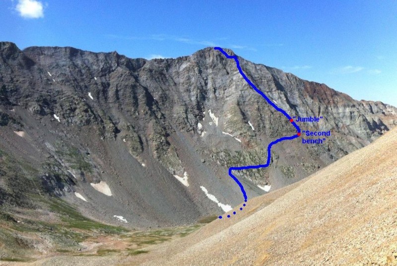
Route up N Buttress as seen from RoA
Instead of descending all the way to the true base of the buttress, we cut over to it through the base of the North Slopes (easy and pretty gentle) and across the grassy ledges of a rock feature. From there, I went up through the boulders on the far side, while Beth went straight up the rock feature, an easier and less scrambly option which she recommends. After that, the feature we aimed for was barely a feature, just a shallow dip in the ridgeline that we generously referred to as a "notch". Getting there involves a thinky traverse across a rather steep scree/boulder area. We found it mostly solid as long as we weren't hasty. Upon arriving at the notch, we were thrilled to pull up photos of the route description and find ourselves exactly at the photo-location of the "second bench" before the "jumble".
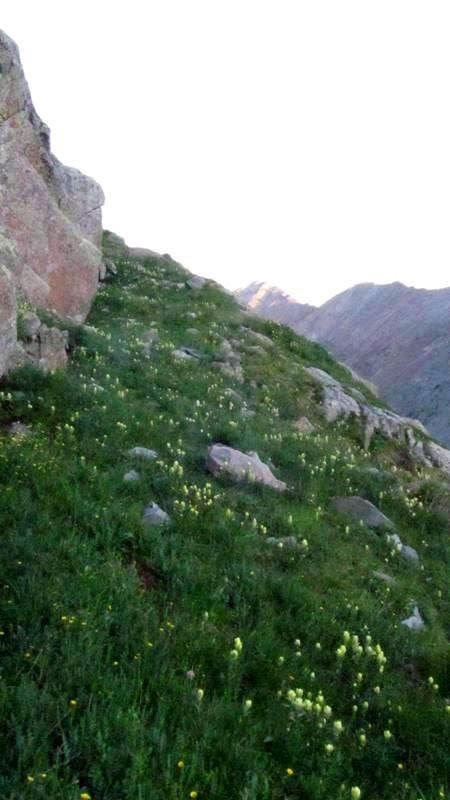
Route along grassy ledges thru rock feature
The grassy ledges
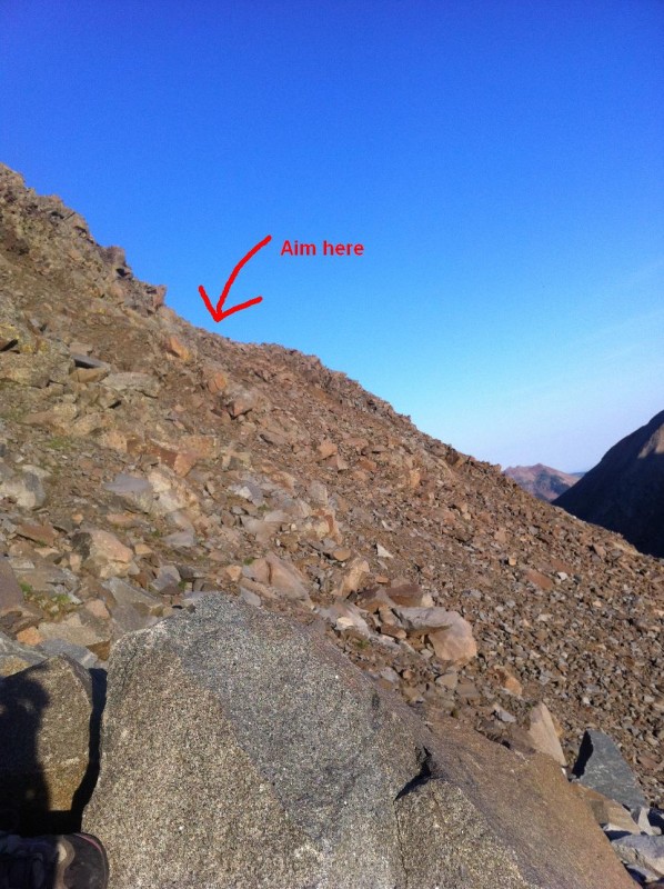
Aim for this "notch" to arrive at the "second bench"
Though we were thrilled to be "on route" at that point, we only occasionally referred to the route description for the remainder of the climb. All you really need to do is follow the ridgeline up to the bowl at the base of the summit. It doesn't matter where exactly you go as long as you feel comfortable about where you are. As for the final section in that bowl, we accidentally completed the "crux chimneys" without realizing they were the crux. We sorta popped out of the them and realized we were almost at the summit. It's not that they were wussy moves, it was just that so much of the route had involved fun class 3 and 4 moves that the "crux" blended in with the rest of what we'd done.
Then, ta-dah, the summit! We then completed the traverse, which we found fun and easy for the first two-thirds, then fun and more challenging for the final third. The rock was quite solid and wonderful (except for that one time a boulder cut loose and nearly took Beth out...), the weather was gorgeous, and we had good time. Unfortunately, what goes up must come down, and as Tom Petty so eloquently puts it, coming down is the hardest thing. in short, descending Mount Wilson sucked. It was loose and uninteresting, we were tired and footsore, and we just wanted it to be over. Oh well. Then back up and over the saddle (which wasn't as horrible as we'd thought it would be) and back to camp.
Summary of times (we are average hikers):
car --> RoA saddle: 2 hr 20 min
RoA saddle --> El Diente Summit: 4 hr (some time for finding a route to base of climb)
El Diente summit --> Mount Wilson summit: 2 hr
Mount Wilson summit --> RoA saddle: 2 hr 30 min
RoA saddle --> TH: 2 hr
Throwing in time spent resting on the saddle and at the summits, total RT time was 14 hours
Happy hiking!
Thumbnails for uploaded photos (click to open slideshow):
Thank you for putting this together. Me and my group are deadlocked right now about which combination to attempt next week. The North Buttress seems to be the frontrunner. We are not so thrilled about the traverse though. Would you say that your total trip was at a moderate pace, or were you really pushing hard to make the 14 hour RT?
I'd say it was a moderate pace overall. Weather allowed it to be that way. The only place we really tried to speed through was the approach to RoA saddle bc we'd done it the day before, and we were hiking it at night. The rest of the trip we took brief breaks as needed, did some route finding, took pics, etc. The traverse was quite quick for the first bit, and the final third to Wilson was certainly more challenging and therefore slow. Are you trying to decide which way to do the traverse? Having ascended the traverse to Wilson, I'm pretty sure I wouldn't want to go down there.
with your assessment of the descent off Mt. Wilson. But, it's the price you pay for a great twofer! Congrats on a great traverse, and thanks for a helpful TR.
Alpiner... no, it wasn't a question of which way to do the traverse... it was more ”do we even want to consider the traverse as an option”? If we did it, we would go El D->MtW, but weather and general physical condition will play a huge part in that decision. It seems that once you are on the traverse, you are fully committed to it. Either way, the N. Buttress is looking like a great option for the El D ascent.
Yep, it's a pretty committing traverse. Additionally, after completing the traverse, you have to descend Mount Wilson when you're dog tired, so it's a slow descent and it lands you in Navajo Basin which is still above treeline and therefore a vulnerable place to be if bad weather moves in. Doing each of the peaks separately would probably be a less worrisome and potentially more enjoyable experience for your group, and just think how strong you'll be at the end! Have a good time!
Great job ladies, and thanks for keeping the mountain clean.
Caution: The information contained in this report may not be accurate and should not be the only resource used in preparation for your climb. Failure to have the necessary experience, physical conditioning, supplies or equipment can result in injury or death. 14ers.com and the author(s) of this report provide no warranties, either express or implied, that the information provided is accurate or reliable. By using the information provided, you agree to indemnify and hold harmless 14ers.com and the report author(s) with respect to any claims and demands against them, including any attorney fees and expenses. Please read the 14ers.com Safety and Disclaimer pages for more information.
Please respect private property: 14ers.com supports the rights of private landowners to determine how and by whom their land will be used. In Colorado, it is your responsibility to determine if land is private and to obtain the appropriate permission before entering the property.

 Route up N Buttress as seen from RoA")
 Route along grassy ledges thru rock feature")
 The grassy ledges")
 Aim for this")