Download Agreement, Release, and Acknowledgement of Risk:
You (the person requesting this file download) fully understand mountain climbing ("Activity") involves risks and dangers of serious bodily injury, including permanent disability, paralysis, and death ("Risks") and you fully accept and assume all such risks and all responsibility for losses, costs, and damages you incur as a result of your participation in this Activity.
You acknowledge that information in the file you have chosen to download may not be accurate and may contain errors. You agree to assume all risks when using this information and agree to release and discharge 14ers.com, 14ers Inc. and the author(s) of such information (collectively, the "Released Parties").
You hereby discharge the Released Parties from all damages, actions, claims and liabilities of any nature, specifically including, but not limited to, damages, actions, claims and liabilities arising from or related to the negligence of the Released Parties. You further agree to indemnify, hold harmless and defend 14ers.com, 14ers Inc. and each of the other Released Parties from and against any loss, damage, liability and expense, including costs and attorney fees, incurred by 14ers.com, 14ers Inc. or any of the other Released Parties as a result of you using information provided on the 14ers.com or 14ers Inc. websites.
You have read this agreement, fully understand its terms and intend it to be a complete and unconditional release of all liability to the greatest extent allowed by law and agree that if any portion of this agreement is held to be invalid the balance, notwithstanding, shall continue in full force and effect.
By clicking "OK" you agree to these terms. If you DO NOT agree, click "Cancel"...
The trailhead is easy to access and is paved nicely all the way to the trailhead parking area. No need whatsoever for 4WD.
Because the weather was forecast to produce thunderstorms by noon, we opted to camp the night at the trailhead. Immediately in front of the parking area (where your car lights will shine) is flat room for several tents. Thankfully, the night was beautifully clear and the sky was filled with stars, so we slept in our bags outside of our tent.
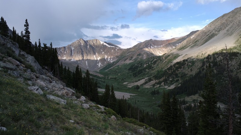
We awoke around 4:30, packed up the tent, had a quick dry breakfast, and started out on the trail around 5:20. At that time, the light was bright enough for hiking and the sun came up soon. The forested part of the trail was light enough to see, although the sun didn't crest the ridge for quite some time. The trail was clear and easy to follow. When we left the trailhead, we were concerned about the building clouds, as there were potentially ominous clouds already gathered to the west. We decided that we'd hike until the weather turned nasty, even if that meant only hiking a few miles.
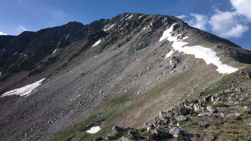
As it turned out, once we started into the main valley, the clouds dissipated. When the trail left the valley floor, the going got quite steep, but the trail is replete with switchbacks, making the ascent quite enjoyable. The large rock that the 14ers.com route guide states as being at 11,800 is more like at 12,200 and is more of a cool rock to look at than a guide point. You can't really see it until you're at it. In any case, the trail is easy to follow. After about 12,750, the trail becomes intermittent as you must hike over large talus rocks, but none of this talus hiking was bothersome: more like nicely placed stairs. And then, lo and behold, just as soon as you think you'll be on rocks to the summit, the dirt trail re-emerges. The cairns are nicely placed and easy to follow.
There were a few patches of oddly shaped snow that looked like a field of soft-serve ice cream cones or the top of a lemon-merangue pie. There is no need to cross the snow, and certainly no ice axe, crampons, or other snow equipment is needed. There were no glissade opportunities.
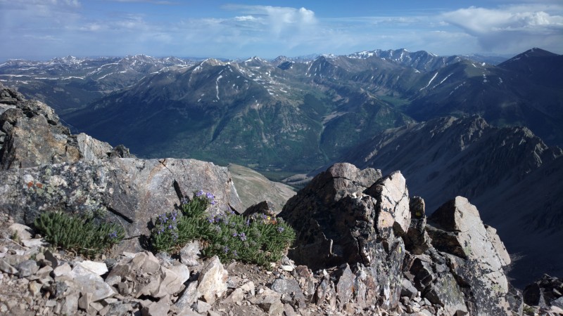
We summitted at 8:40, so the uneventful ascent took us a little over three hours. We're in good shape, but weren't trail running -- just enjoying ourselves at a solid hiking pace. Along the way we saw one mountain goat looking down on us from high above on the ridge. At the summit, the weather was glorious, warm, and calm. We stayed at the summit for about 40 minutes, enjoying the view and conversation with a few other people on the summit. The clouds to the west (over Mount Sherman etc.) were definitely raining over there. We felt fortunate to be beneath a large window of blue sky. We did not hear any thunder until we were about half-way down our descent.
We returned via the same route. The path down was definitely harder on my thighs than the ascent. I was very glad to have trekking poles to help protect my knees on the descent. We returned to the trailhead a bit after 12:00, so the descent took about as long as the climb up, which surprised me. I guess we slowed down considerably in the end, due to fatigue and sore quads.
On the drive home along I70, there was a lot of rain. I'm glad we camped at the trailhead and started our ascent just before dawn!
Dawn breaking over the valley (La Plata is up the slopes to the left, out of view) View toward the summit View from the summit Valley on the descent
Thumbnails for uploaded photos (click to open slideshow):
Great report. I appreciated some of the details. We may be knowcking this off next month. Thanks again.
Caution: The information contained in this report may not be accurate and should not be the only resource used in preparation for your climb. Failure to have the necessary experience, physical conditioning, supplies or equipment can result in injury or death. 14ers.com and the author(s) of this report provide no warranties, either express or implied, that the information provided is accurate or reliable. By using the information provided, you agree to indemnify and hold harmless 14ers.com and the report author(s) with respect to any claims and demands against them, including any attorney fees and expenses. Please read the 14ers.com Safety and Disclaimer pages for more information.
Please respect private property: 14ers.com supports the rights of private landowners to determine how and by whom their land will be used. In Colorado, it is your responsibility to determine if land is private and to obtain the appropriate permission before entering the property.