Download Agreement, Release, and Acknowledgement of Risk:
You (the person requesting this file download) fully understand mountain climbing ("Activity") involves risks and dangers of serious bodily injury, including permanent disability, paralysis, and death ("Risks") and you fully accept and assume all such risks and all responsibility for losses, costs, and damages you incur as a result of your participation in this Activity.
You acknowledge that information in the file you have chosen to download may not be accurate and may contain errors. You agree to assume all risks when using this information and agree to release and discharge 14ers.com, 14ers Inc. and the author(s) of such information (collectively, the "Released Parties").
You hereby discharge the Released Parties from all damages, actions, claims and liabilities of any nature, specifically including, but not limited to, damages, actions, claims and liabilities arising from or related to the negligence of the Released Parties. You further agree to indemnify, hold harmless and defend 14ers.com, 14ers Inc. and each of the other Released Parties from and against any loss, damage, liability and expense, including costs and attorney fees, incurred by 14ers.com, 14ers Inc. or any of the other Released Parties as a result of you using information provided on the 14ers.com or 14ers Inc. websites.
You have read this agreement, fully understand its terms and intend it to be a complete and unconditional release of all liability to the greatest extent allowed by law and agree that if any portion of this agreement is held to be invalid the balance, notwithstanding, shall continue in full force and effect.
By clicking "OK" you agree to these terms. If you DO NOT agree, click "Cancel"...
| Report Type |
Full |
| Peak(s) |
Quandary Peak - 14,272 feet
|
| Date Posted |
01/18/2013 |
| Modified |
01/21/2013 |
| Date Climbed |
01/16/2013 |
| Author |
boudreaux |
| Winter Quandary |

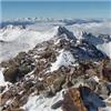
I'm just gonna post a few photos of the day, it was a very nice day. Started out with a little fog at the TH, but by the time we reached the krumholtz, we were above the clouds and the temps went from 15 degrees to 30 degrees. Not much snow on the mountain above the treeline. The packed trail was sometimes 8" higher than the adjacent slope, just shows how much the wind has scoured this peak.

All the snow is at or below the treeline


You can see in these two pictures how little snow there is. I was amazed that Brec or Copper was doing some avy control that day. The wind is always working, but geez!
I met Tockelstein2005 in Breckenridge and we drove up to the TH in the fog, we got a nice view of the summit as we passed The Skier's Edge. We had a little trouble on the 1st slope at the last signpost, the packed trail disappeared beneath the wind blown snow and it was searching for the trail with my poles, kinda like doing avy rescue training, but it worked and saved us from deep postholing. After that it was smooth sailing on the packed trail.
At about 12,400, my left foot got really cold and Tockelstein continued on without me. But after about 10 minutes I ran into a large group of guys from 14ers.com. They encouraged me to try the warmers, and was glad I did. I think this added about 400' to my day and by the time I was approaching the summit I was almost crawling up, Tockelstein was coming back down, I guess I was about 45 minutes behind him or so. High above the clouds, I could see the clouds spilling over Hoosier Pass and the Continental Divide like water pouring out of a bowl. I just was glad the hard part was over, I think I need a little more fitness or something, that was a struggle. I'm just like a horse, point me toward the barn and I know the feed bag is in there waiting for me, so going down was no problem!

East slopes look loaded on Atlantic, Fletcher/Atlantic Ridge is my favorite!

Red Mountain/Hoosier Ridge west slopes look wind bown and sparse
He slowed down for me to catch up and I rejoined him at the flat part of the ridge just below the summit pyramid. It was a good day, Tockelstein got his 14er and we enjoyed some good company on the trail. The fog moved off to the south and the hike back down to the TH was no problem in the fading light of the late afternoon.
Thumbnails for uploaded photos (click to open slideshow):
")
")
")
")
")
")
")
")
")
|
Caution: The information contained in this report may not be accurate and should not be the only resource used in preparation for your climb. Failure to have the necessary experience, physical conditioning, supplies or equipment can result in injury or death. 14ers.com and the author(s) of this report provide no warranties, either express or implied, that the information provided is accurate or reliable. By using the information provided, you agree to indemnify and hold harmless 14ers.com and the report author(s) with respect to any claims and demands against them, including any attorney fees and expenses. Please read the 14ers.com Safety and Disclaimer pages for more information.
Please respect private property: 14ers.com supports the rights of private landowners to determine how and by whom their land will be used. In Colorado, it is your responsibility to determine if land is private and to obtain the appropriate permission before entering the property.
")
")
")
")
")
")
")
")
")