Download Agreement, Release, and Acknowledgement of Risk:
You (the person requesting this file download) fully understand mountain climbing ("Activity") involves risks and dangers of serious bodily injury, including permanent disability, paralysis, and death ("Risks") and you fully accept and assume all such risks and all responsibility for losses, costs, and damages you incur as a result of your participation in this Activity.
You acknowledge that information in the file you have chosen to download may not be accurate and may contain errors. You agree to assume all risks when using this information and agree to release and discharge 14ers.com, 14ers Inc. and the author(s) of such information (collectively, the "Released Parties").
You hereby discharge the Released Parties from all damages, actions, claims and liabilities of any nature, specifically including, but not limited to, damages, actions, claims and liabilities arising from or related to the negligence of the Released Parties. You further agree to indemnify, hold harmless and defend 14ers.com, 14ers Inc. and each of the other Released Parties from and against any loss, damage, liability and expense, including costs and attorney fees, incurred by 14ers.com, 14ers Inc. or any of the other Released Parties as a result of you using information provided on the 14ers.com or 14ers Inc. websites.
You have read this agreement, fully understand its terms and intend it to be a complete and unconditional release of all liability to the greatest extent allowed by law and agree that if any portion of this agreement is held to be invalid the balance, notwithstanding, shall continue in full force and effect.
By clicking "OK" you agree to these terms. If you DO NOT agree, click "Cancel"...
Mt Wilson, Kilpacker and South Slopes: Class 2+, 3
Mt. Wilson, South Slopes from Kilpacker Basin. No Class 4 summit block, but miles of talus.
- #42 for me.
- Useful trip reports: Kitten, 08/27/2011. LynnKH, 09/03/2010. Carl, 07/03/2010. Dancesatmoonrise, 08/08/2011
- Highly useful report I wish had been posted before we departed: highpilgrim, 7/26/2012
- Roundtrip from Kilpacker Trail Head via El Diente: 15 miles.
- Camped overnight in Kilpacker near stream about 2.5 miles in.
- Departed Camp: 4:00AM
- Summited El Diente: 7:50AM
- Summited Mt. Wilson: 10:45AM
- Met along the way: Alan from Vernal Utah, LOVENIT.
- Biggest surprise: Going up El Diente you have to stay on the gray talus almost to the ridgeline
- Many thanks to Kitten and MountainMike for talking me though the plan on the phone ahead of time.
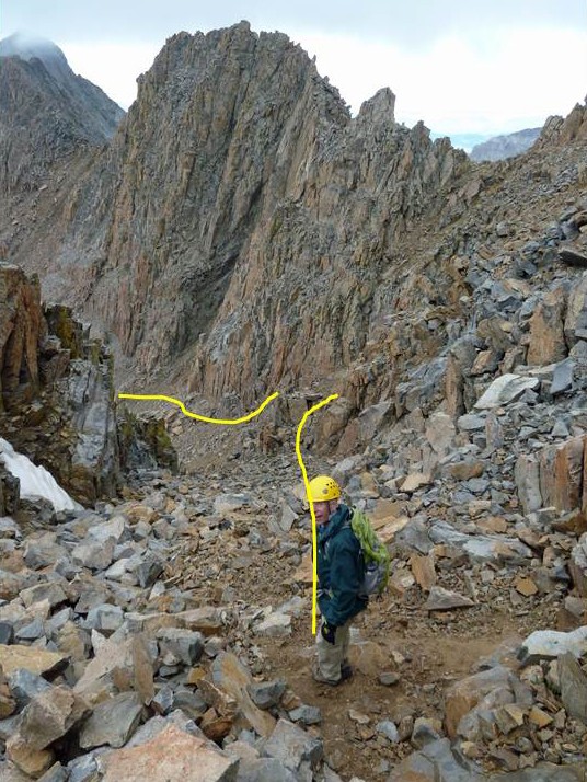
The south slopes climb from Kilpacker to El Diente is straight forward, so I won't discuss that much here. The only surprise we had was that we had to climb almost to the ridge line between El Diente and Mt. Wilson before heading back west under the Organ Pipes toward the notch to the north slope.
Coming off El Diente, we got to the bottom of the Gray Talus and tried to maintain our altitude by contouring at around 13,500 feet. This was a mistake. We would have made better time had we descended another 250 feet where the talus was a little larger and a little flatter. If you are standing at the base of the gray talus looking east toward the east end (toward Mt Wilson) and are thinking of crossing to the red rocks across small, red talus. Don't do it. We did. It's like trying to move on steeply stacked marbles.
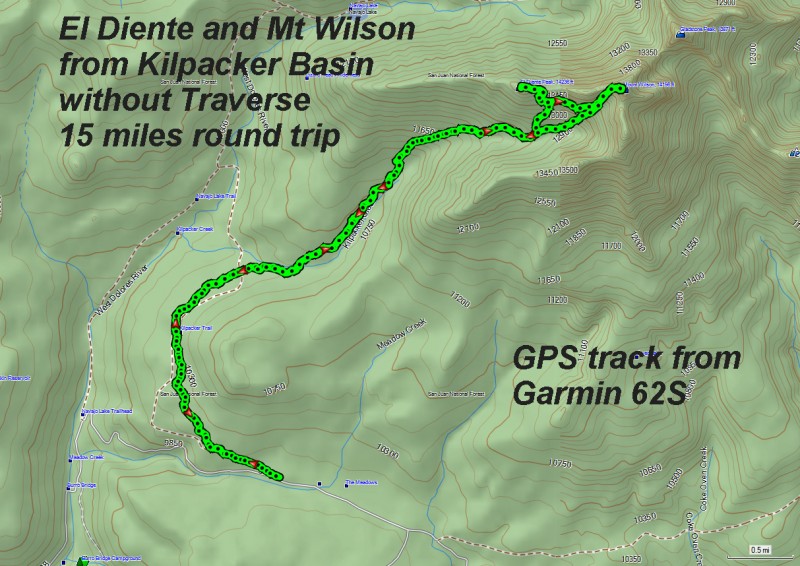
The image above is an Overview of the entire route from Parking.
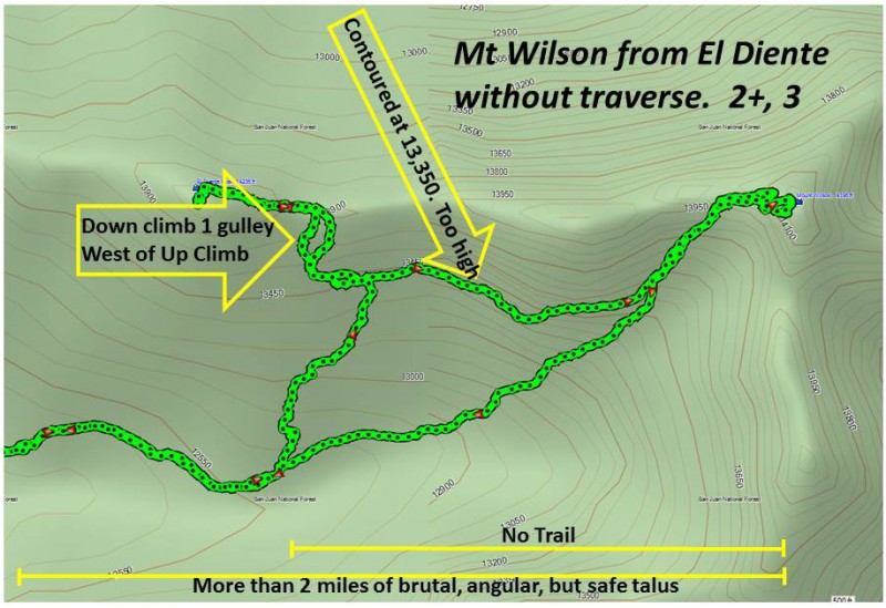
The image above shows a closer view of the GPS track from Kilpacker to El Diente then on to Mt Wilson. There is a lot of work off trail. As the word spreads, I won't be surprised to find this route become more popular. Except for the long walk on talus, the climb is much easier than the north slopes: Nothing really harder than a few Class 3 moves, unless you take the shallow gully which is Class 4+ on very nice rock (with just a few loose handholds). Note, on this image, we took a more western route when we down climbed off El Diente (down the gray talus). The rock looked more stable. This route has been used extensively by others as noted from the cairns on it.
Up and over the upper waterfall, El Diente will pass on your left
The image above is a shot is taken from the Down Climb back into Kilpacker, but it gives a good idea of what to expect on the way up.
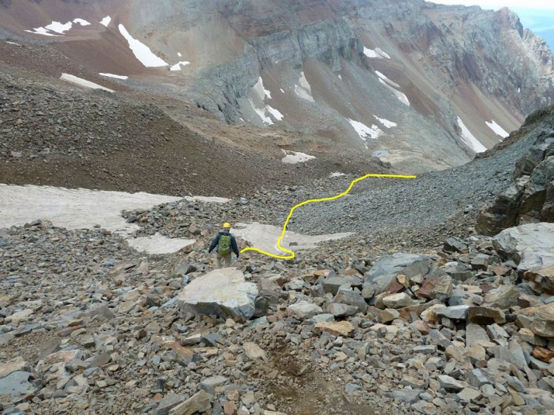
If you climb with a GPS, you are shooting for a spot at the base of the gullies coming off the south side of Mt. Wilson (N37° 50.337 W107° 59.579). You cannot see this spot (in the photo above) from Kilpacker until you are very close to it.
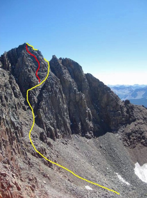
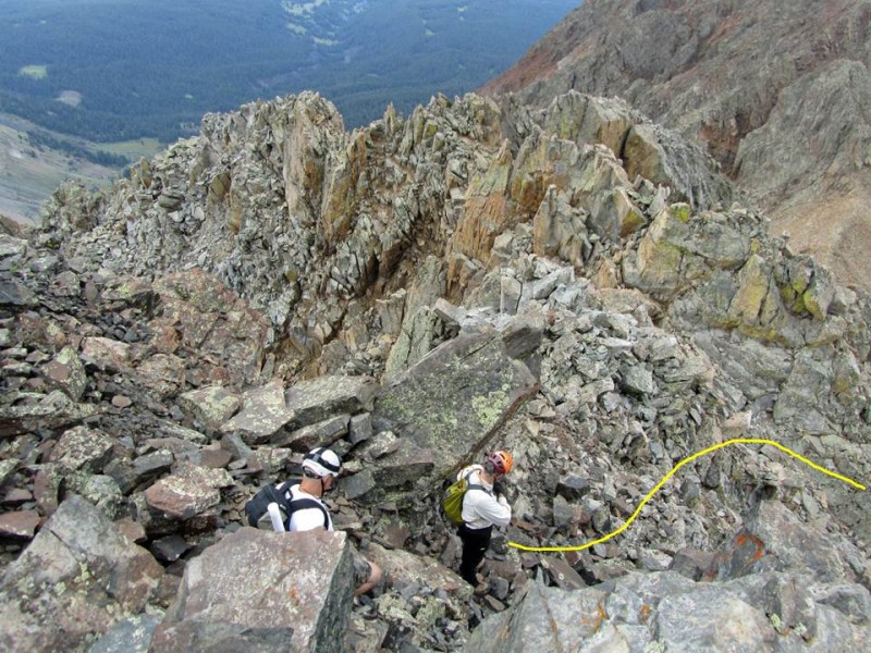
This shot above is taken from another trip report (from the traverse). It gives a good idea of what you are shooting for. The yellow line shows the easiest route (Class 2+, 3). If you want a more challenging climb (Class 4 on great rock), choose the shallow gulley (red line) that appears as soon as you make the contour across the easy Class 3 section. It appears on your left. This was actually a mistake we made due to my error in trip planning. However, it turned out to be a lot of fun, if you are into steep, exposed terrain.
The screen shot above is a closer view of the GPS track.
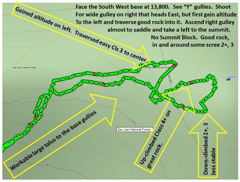
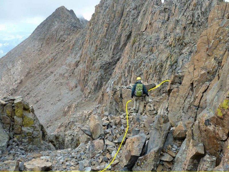
See Ernie, in the image above, at the base of the "Y" shaped gullies. He is going to cross the base of the "Y" from climber's left to right, cross some easy Class 3 into the wide gulley that heads West to East and up. Just over Ernie's left (climbers left) shoulder, you cannot see the colouier that heads straight up to the summit notch. If you take this, you will end up in the same place you would had you done the traverse. By heading more east up the wide gully in front of Ernie, the climb is easier with no need to get over the exposed Class 4 summit block.
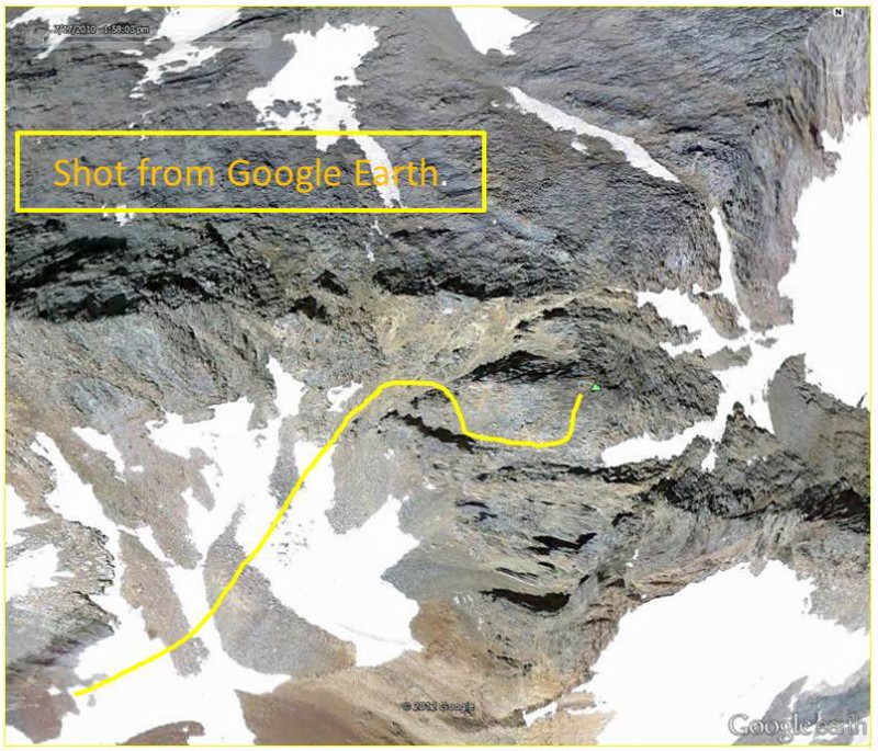
The image above from Google Earth is simply another view. It gives a good idea of the orientation of the gulley you are looking for to the E-W.
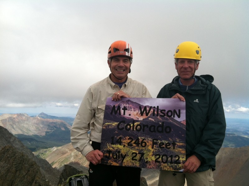
Above is the obligatory summit shot. Lest you think we are really organized, LOVENIT brought the really cool sign along. In the next shot you can see Alan with a white tube sticking out of his backpack. He brought the sign along.
The weather was not near as bad as it looks in this photo. There was some sort of interesting short wave weather system moving through that brought a zooming AltoStratus deck across the range at about 14,500 feet ASL. There was no convection present. By the time we got back in the basin, this phenomenon had moved through so that insolation could begin forming cumulus castelanous again. We had a few drops of rain from the cumulonimbus clouds by about 3PM. By this time we had pulled up camp and were hiking back to the car.
The photo above is of Alan and Vort beginning the down climb into the gulley right off the SSW corner of the summit. Walk to the east end of the summit, sit on a large flat rock, and drop about 4 feet directly into the Class 2+, 3 gulley that takes you to safety.
Above, Ernie is in the E-W gulley (not steep). If he continues straight down, he runs into a very steep section, so instead, he takes the route we climbed on the way up. It's an easy Class 3 contour into the next gulley to the west, then very simple from there.
The image above is a closer shot of Ernie taking the traverse into the other gulley. It's very simple.
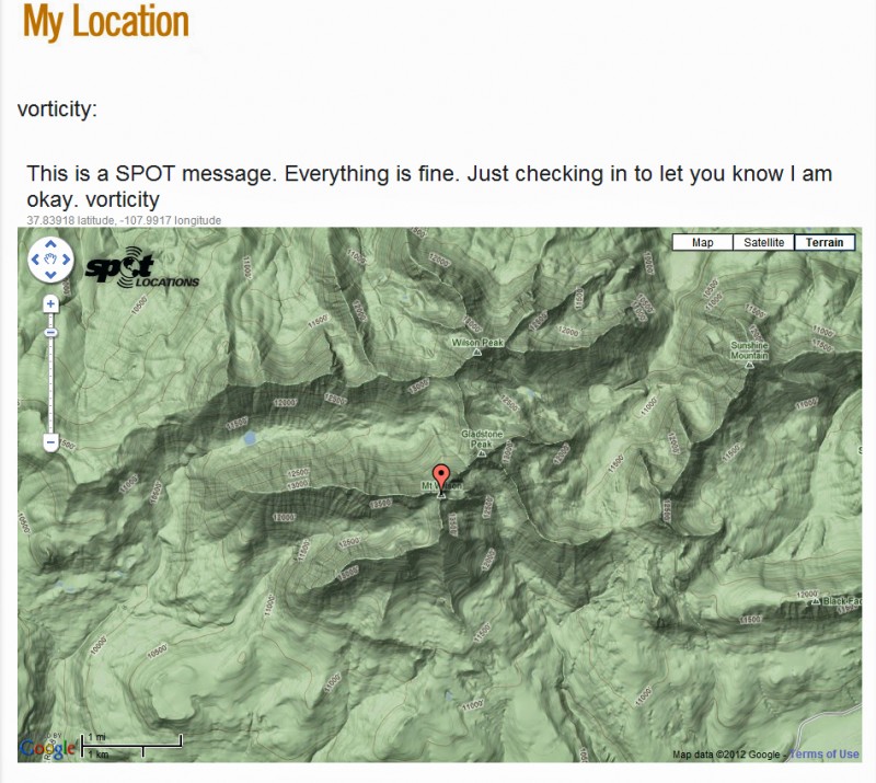
I use a location identifier so my wife and family know I am still alive. This is what they get in an email.
My GPS Tracks on Google Maps (made from a .GPX file upload):
Congratulations on a great TR and hike! I am sure many people will find your description of the route extremely helpful. Nice GPS graphs and maps describing the route. Well done!
I just did it this past Sunday based on a trip report from Highpilgrim, I crossed the rib between the two gullies too high and got a bit of taste of that class 4 you are talking about. Pretty solid but exposed to me. Unfortunately, I had much more rain this weekend, so was pushed away from ElDiente twice and will have to return there once more.
I plan on this climb over the coming weekend. Your report will go a long way in helping us efficiently make the climb in what looks to be a tighter and tighter weather window. Thanks for taking the time to share your experience and insight with the community.
I’m planning on using this route later this Summer and your route description makes this doable. Thanks for all the details and the GPX file!
Caution: The information contained in this report may not be accurate and should not be the only resource used in preparation for your climb. Failure to have the necessary experience, physical conditioning, supplies or equipment can result in injury or death. 14ers.com and the author(s) of this report provide no warranties, either express or implied, that the information provided is accurate or reliable. By using the information provided, you agree to indemnify and hold harmless 14ers.com and the report author(s) with respect to any claims and demands against them, including any attorney fees and expenses. Please read the 14ers.com Safety and Disclaimer pages for more information.
Please respect private property: 14ers.com supports the rights of private landowners to determine how and by whom their land will be used. In Colorado, it is your responsibility to determine if land is private and to obtain the appropriate permission before entering the property.


")
")
")
")
")
")
")
")
")
")
")
")
")
")
")
")
")
")