Download Agreement, Release, and Acknowledgement of Risk:
You (the person requesting this file download) fully understand mountain climbing ("Activity") involves risks and dangers of serious bodily injury, including permanent disability, paralysis, and death ("Risks") and you fully accept and assume all such risks and all responsibility for losses, costs, and damages you incur as a result of your participation in this Activity.
You acknowledge that information in the file you have chosen to download may not be accurate and may contain errors. You agree to assume all risks when using this information and agree to release and discharge 14ers.com, 14ers Inc. and the author(s) of such information (collectively, the "Released Parties").
You hereby discharge the Released Parties from all damages, actions, claims and liabilities of any nature, specifically including, but not limited to, damages, actions, claims and liabilities arising from or related to the negligence of the Released Parties. You further agree to indemnify, hold harmless and defend 14ers.com, 14ers Inc. and each of the other Released Parties from and against any loss, damage, liability and expense, including costs and attorney fees, incurred by 14ers.com, 14ers Inc. or any of the other Released Parties as a result of you using information provided on the 14ers.com or 14ers Inc. websites.
You have read this agreement, fully understand its terms and intend it to be a complete and unconditional release of all liability to the greatest extent allowed by law and agree that if any portion of this agreement is held to be invalid the balance, notwithstanding, shall continue in full force and effect.
By clicking "OK" you agree to these terms. If you DO NOT agree, click "Cancel"...
Mt Champion, Pt 13,736, Fairview Peak A, Jenkins Mountain, Pt 13,140, Grizzly Peak E
I had been planning all week to hit up the San Juans for 3 days of 13ers in a completely new area of Colorado. That was, until the forecast went from 40-50% storms to 60-70% storms. Driving 6+ hours to an area I hadn't seen before is really only worth it if I can see where I am! After my experience 2 weeks ago, with only having a 5 hour window of rain/hail/lightning free hiking, I didn't want to chance such a long drive, for a possibility of a low return.
So, with only an hour or two before I left work to drive into the mountains, I changed my plans, at least 2 or 3 times, to something closer. Sawatch, here I come, again. They had the best forecast of all the ranges, again. Darn.
After narrowly missing hitting a deer that decided to run along side my truck as I was slamming on the brakes, I pull into the trailhead at the first major switchback up Independence Pass to catch a decent nights rest. That is, after I calmed down from the near accident.
Started up the nice trail into the basin at first light. Continued along the trail until I veered east to get over to the north ridge of Pt 13,736. The ridge section will gain you the majority of the elevation gain for the day along this particular loop. You can keep it class 2 if you like. But there is also some minor class 3 if you seek it out on very solid rock.
North ridge of Pt 13,736 More north ridge
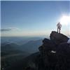
Once on the summit of Pt 13,736, the ridge over to Mt Champion looked fairly easy, so after a quick break to snap some pics of the surrounding peaks I've done, or will do, I was off.
Twinning and Pt 13,545 with the Elks behind Deer Mtn, K 49, Oklahoma and Mt Massive Ridge to Mt Champion Ridge from Pt 13,736
Once on the summit of Champion, I took some time looking south at the centennials that I'll eventually do with Darrin. The weather had been building, as promised, so I started my descent. It was a rather painful descent as it was steep and unrelenting. But I had some entertainment along the way, as I startled a family of ptarmigan, and watched the babies run away. I spent some time chasing the butterflies down the slope, trying to capture the elusive orange and green ones on my camera. A helicopter buzzed me, and returned for another round. I wondered if they thought I was lost?
Then I discovered the Champion Mine ruins down the slope. Here I couldn't resist taking a peek around to get some photos. As I angled back to the trailhead, I even came across an old mining shaft, which I carefully explored for the first few feet.
Champion mine with Casco and French behind An old mining wheel with Grizzly behind A mining shaft to carefully explore
After the exploration, it was a tiring and slightly painful descent, using whatever game trails I could find.
Day 2: Fairview Peak A
Mileage: 7.3
Elevation Gain: 2,426'
Trailhead: Cumberland Pass
After studying a few maps, I decided to try Fairview Peak from Cumberland Pass. There's almost no information on this peak anywhere on the web. So I didn't know about access from the south, which looked longer in the vehicle, but shorter on the trail. Oh well, someone else can explore another route on this peak, which affords views of every major range in Colorado, except the Gore.
With the storms building, I didn't want to camp directly on the pass, so I went up and over and camped next to some mining ruins. Hmmm a theme starting? Thankfully I had a little bit of time to grill my dinner outside before the rain started. Enough to see that the stream nearby had milky white water, and was probably contaminated from the mine above. After a round of storms, I could see the slopes by the pass had been flocked with white graupel. Glad I wasn't up there!
The next morning I went back up the pass and parked out of the way of the many vehicles to visit the pass. The sky changes to red as I get ready. Red sky at morning, sailors warning? Storms are predicted after 9am today. Better get going!
First light over the Sawatch Red sky over Fairvew Peak
From the pass, I head down a trail marked on my Nat Geo map, which goes through private property of an old mine. From there it's a walk on 4x4 roads and eventually a faint trail up and down the ridges. Today would be all about the numerous ups and downs along the ridge up to the summit.
Fairview Peak Still more ridgeline to go!
It didn't take very long to get to the top, and since it was still clear blue skies over head, I spent some time looking at my 360 degree view of all the mountains ranges I could see. Even Pikes could be seen through a gap in the Sawatch!
The nearby Henry Mountain
A curious Pika
On the return... lots of ridge!
On the way down, I spent a little time exploring around all the mining claims. I found some interesting crystals and minerals. Quite a bit of green malachite in some of the pits.
The maps and profile:
The many ups and downs...
Day 3: Jenkins, Pt 13,140 Grizzly Peak E
Mileage: 8.4
Elevation Gain: 4,396'
Trailhead: Pieplant Mill
I got to the Pieplant Mill site fairly early on in the day, so I spent some time exploring the area and snapping some pics of the mining ruins. I even found a very curious critter begging for food by mugging to the camera. Quite the ham! Soon enough the storm rolled through, and I was once again stuck in the back of my truck reading.
Do you have any food?
Vogue, strike a pose.
The morning started off with the bleating of Elk as they cavorted in the neighboring field with fog forming around them. Of course after reading about direwolves the night before, I had doubts at first whether they were elk or wolves. But once the light got better, I could see that they were elk, and nothing more dangerous. I carried my bear spray anyway, as I had a long section of woods to go through before getting into the open.
I decided to take a minor detour over to the Pieplant Mine site, but was fairly disappointed with the lack of anything left. Just a tiny building and garbage lying around. Though as I had a nice mining road to follow through the woods for a good stretch, it wasn't a bad trade. I left the mining road to follow a stream drainage up till I found a nice path to the ridge proper. You could follow the mining road, but it ends in a large rock slide/mine blast site that may be tricky to get above.
I had been trying to hustle above treeline for the view of the fog in the valley below. I knew I wouldn't make sunrise, but I still wanted some long shadows.
A foggy morning! Fog in front of Fairview Peak
Once high on the ridge, navigation is pretty easy. The summit is the bump on the far right. Here I got a view of some new 13ers that I hadn't seen before, let alone from this angle. As there was still some residual clouds in the area, and the storms were a high probability again today, I didn't spend much time on the first of 3 summits.
some 13ers
The ridge over to 13,140 was going to be the toughest so far. So I moved as quickly as I could along the easy first section, so I could spend more time at the final crux section.
Ridge to Pt 13,140 The crux section of 13,140
Once at the crux, you have a few options. You can drop to the east and then west to get around them (on loose nasty terrain), or you can go up an over on loose exposed class 3 blocky rock with plenty of trundling possibilities. I chose to dodge around, as loose and exposed is not my idea of fun. Not that my option was better. But I felt more comfortable with it solo, as I didn't want to go up a gendarme, only to find the way off it was bad.
At the start of the crux section The first gendarme Loose terrain around the gendarmes Looking back at Jenkins Last gendarme with the summit behind Looking back at the final gendarme
Even the last stretch up to the summit was a matter of finding what rock looked the most stable on the pile of loose dirt that felt like it wanted to be down in the valley below. The slope has exceeded the natural angle of repose! Don't think I've every climbed a peak that was so unstable before.
The clouds were building around me, but not above, or along the wind line in front of me. So I knew I had time to make it over to Grizzly, if I hustled. So just a few minutes to snap some pics on the summit and then I was off.
some 13ers
I had originally though to stay on the ridge line and explore the second half of the traverse. But looking at it, I didn't think I had the time to waste finding my way. Plus looking back on it from Grizzly there are some interesting overhanging sections that I wouldn't want to be on, in case 'geologic time is now'. So I dropped once I reached the first natural saddle, and scree skied to the bottom.
View of Grizzly, after dropping to the valley below The ridge from 13,140 looks doable, just annoying
Once on the final summit for the day, and for the trip, I took a little time to catch my breath and look around.
The 3 Apostles
The descent was a nasty steep talus pile of tripping waiting to happen. Felt like I was on a tilt-a-whirl. After awhile I went into the drainage between the two west facing ridges and had a better time of it.
Eeeevil but pretty plant
In the trees I angled and contoured back to the truck, through a forest that had obviously burned before. Plenty of charred trees on the ground.
A look back at Jenkins 13,140 and Grizzly E
This completed my very impromptu tour of Sawatch mining history!
My GPS Tracks on Google Maps (made from a .GPX file upload):
I was just looking at Mount Fairview the other day because I noticed it when I did Harvard and Columbia last wknd. I've had Jenkins and Grizzly on my mind too, but from the East.
Highest Fire Lookout in North America ... 7/26/2012 2:23pm
Fairview Peak ... at least it used to be back in the day (much historical data with that peak). The 360 degree views are awesome. Great trip report, Otina. I always value those less popular summits. Thanks for posting. Happy trails! :D
geojed - I have those peaks to the east of Jenkins-Grizzly planned for a time when the monsoon won't chase me off the long ridge run.
RJansen77 - Once you finish 'the list', there's plenty to explore!
FireOnTheMountain - I changed my Sunday plans as I was driving down from Cumberland Pass! With the weather more ”stabilized” I decided to scrap my more conservative plan, for a better one! Gotta be flexible, the weather rules all!
Caroline - I'll only have a couple more open weekends like this, this summer/fall, better clear your schedule of random dog sitting on Saturdays :wink:
mountainmicah83 - Yeah, I was blown away by the scenery once I dropped off the other side of Cottonwood Pass. It's why I am thoroughly enjoying the 13ers! Going places I haven't seen before.
Presto - That makes sense, on the fire lookout. It was hard to leave the summit because of those views. Normally I prefer the closer spaced peaks, but this one was so dramatic like Pikes is on the sweeping views!
I had a lot of fun poking around the buildings at Pieplant when I did those peaks. The ridge around 13140 was a surprise, there are a few of those in the Sawatch 13ers from time to time!
Thanks for the route on Fairview, I have been on the other side but I can't drive my vehicle up that road, the 2WD Cumberland Pass route would be a nice way to go.
And Otinas TRs are still useful. Did your route on champion/13736, but in reverse. A nice way to avoid the regain of elevation on the standard out and back route. And that drainage down North fork lake creek is very pretty
Caution: The information contained in this report may not be accurate and should not be the only resource used in preparation for your climb. Failure to have the necessary experience, physical conditioning, supplies or equipment can result in injury or death. 14ers.com and the author(s) of this report provide no warranties, either express or implied, that the information provided is accurate or reliable. By using the information provided, you agree to indemnify and hold harmless 14ers.com and the report author(s) with respect to any claims and demands against them, including any attorney fees and expenses. Please read the 14ers.com Safety and Disclaimer pages for more information.
Please respect private property: 14ers.com supports the rights of private landowners to determine how and by whom their land will be used. In Colorado, it is your responsibility to determine if land is private and to obtain the appropriate permission before entering the property.


 North ridge of Pt 13,736")
 More north ridge")
 Twinning and Pt 13,545 with the Elks behind")
 Deer Mtn, K 49, Oklahoma and Mt Massive")
 Ridge to Mt Champion")
 Ridge from Pt 13,736")
 Champion mine with Casco and French behind")
 An old mining wheel with Grizzly behind")
 A mining shaft to carefully explore")
 First light over the Sawatch")
 Red sky over Fairvew Peak")
 Fairview Peak")
 Still more ridgeline to go!")
 On the return... lots of ridge!")
 A foggy morning!")
 Fog in front of Fairview Peak")
 some 13ers")
 Ridge to Pt 13,140")
 The crux section of 13,140")
 At the start of the crux section")
 The first gendarme")
 Loose terrain around the gendarmes")
 Looking back at Jenkins")
 Last gendarme with the summit behind")
 Looking back at the final gendarme")
 some 13ers")
 View of Grizzly, after dropping to the valley below")
 The ridge from 13,140 looks doable, just annoying")
 The 3 Apostles")
 A look back at Jenkins 13,140 and Grizzly E")