Download Agreement, Release, and Acknowledgement of Risk:
You (the person requesting this file download) fully understand mountain climbing ("Activity") involves risks and dangers of serious bodily injury, including permanent disability, paralysis, and death ("Risks") and you fully accept and assume all such risks and all responsibility for losses, costs, and damages you incur as a result of your participation in this Activity.
You acknowledge that information in the file you have chosen to download may not be accurate and may contain errors. You agree to assume all risks when using this information and agree to release and discharge 14ers.com, 14ers Inc. and the author(s) of such information (collectively, the "Released Parties").
You hereby discharge the Released Parties from all damages, actions, claims and liabilities of any nature, specifically including, but not limited to, damages, actions, claims and liabilities arising from or related to the negligence of the Released Parties. You further agree to indemnify, hold harmless and defend 14ers.com, 14ers Inc. and each of the other Released Parties from and against any loss, damage, liability and expense, including costs and attorney fees, incurred by 14ers.com, 14ers Inc. or any of the other Released Parties as a result of you using information provided on the 14ers.com or 14ers Inc. websites.
You have read this agreement, fully understand its terms and intend it to be a complete and unconditional release of all liability to the greatest extent allowed by law and agree that if any portion of this agreement is held to be invalid the balance, notwithstanding, shall continue in full force and effect.
By clicking "OK" you agree to these terms. If you DO NOT agree, click "Cancel"...
The new Rock of Ages trail to Wilson Peak officially opened on August 3, and I was anxious to check it out. The new trail, according to the Forest Service brochure that I picked up, begins at an elevation of 10,383 feet, and proceeds to the Rock of Ages saddle. The Forest Service brochure lists the elevation of the Rock of Ages Saddle to be 13,400 feet, the route description on 14ers.com lists the elevation at the saddle to be 13,000 feet, and my GPS indicated the elevation at the saddle to be 13,100 feet. Go figure.
The trail to the Rock of Ages Saddle is a Class 1 hike all the way to the saddle, with numerous signs marking the way:
Here's a view of the Rock of Ages saddle from the trail:
And a view of Wilson Peak from the trail:
Once you reach the Rock of Ages saddle, turn left (northeast) to climb Wilson Peak. An easy Class 1 trail follows the length of the saddle.
Here's a view from the saddle, looking back:
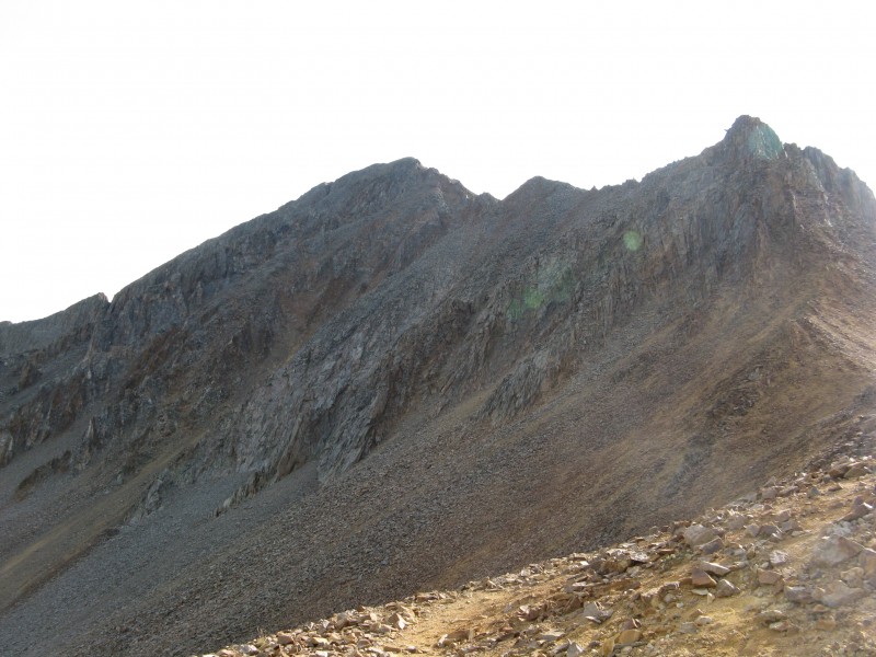
A dramatic change of conditions greets you after traversing the length of the saddle. From that point on, there are trail segments and occasional cairns, but the route to the summit becomes difficult to follow, and some occasional scrambling is necessary.
Here's a view of the summit from around 13,500:
This is a tough climb, with lots of exposure. It's every bit as hard as it looks. A hiker who was descending said that she was turning back because it was too scary.
At 13,500 I became concerned not by the exposure, which really didn't bother me, but by the weather. Dark clouds were starting to build up in the area. These are the types of clouds that when I am flying I avoid like the plague:
The tedious route finding and scrambling had slowed my pace considerably, and I became concerned about whether I would have time to gain the summit and be back at the trailhead by dark. So at 13,500 I turned back.
On my descent I did not encounter a thunderstorm, but did encounter some snow flurries. I'll take snow flurries over a thunderstorm any day.
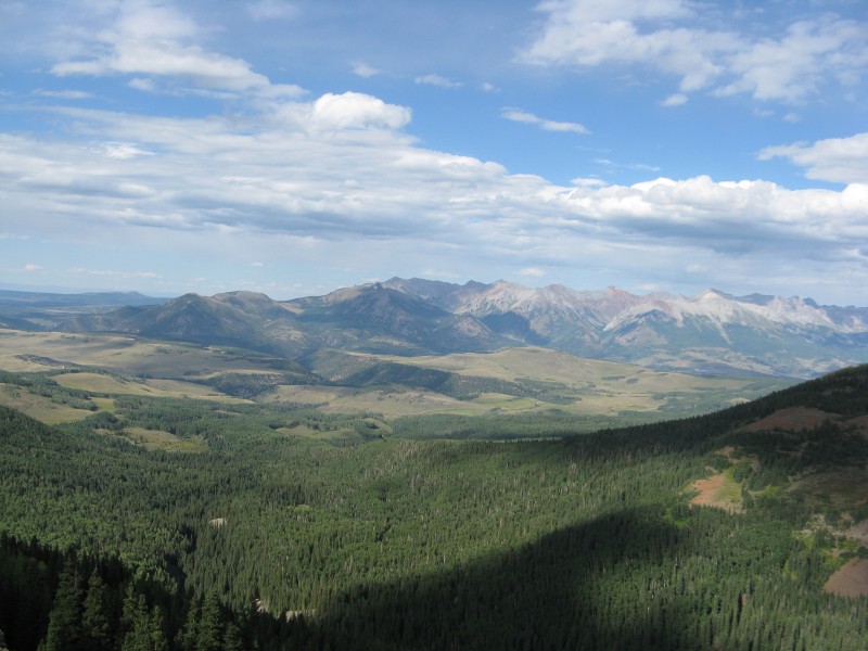
By the time I reached treeline on my descent, the weather had cleared. At treeline I had this nice view to the east:
Back at the trailhead I encountered a hiker who said that she enjoyed the climb because it was "sporty". I guess "scary" and "sporty" are matters of personal perspective.
Many thanks to those involved in re-establishing public access to Wilson Peak:
Thumbnails for uploaded photos (click to open slideshow):
My perspective is that what seems 'scary' when observing becomes 'sporty' when doing.
The gash between the false and true summit is a perfect example - looking at it head-on from the false summit it looked pretty scary, but once you make the moves down into the gash it starts to fall into place and make sense. And you can see how it works out.
By the way, I think staying to the far right is the best route up the summit side. Bill's route description indicates to cross over to the left just below what appears to be a small cave-type feature - but we found that staying right is much better.
They must have really changed that trail from the Wilson Peak/Gladstone saddle ... just a couple of years ago, that was a very easy to follow footpath all the way to the false summit (no exposure involved). :shock:
Caution: The information contained in this report may not be accurate and should not be the only resource used in preparation for your climb. Failure to have the necessary experience, physical conditioning, supplies or equipment can result in injury or death. 14ers.com and the author(s) of this report provide no warranties, either express or implied, that the information provided is accurate or reliable. By using the information provided, you agree to indemnify and hold harmless 14ers.com and the report author(s) with respect to any claims and demands against them, including any attorney fees and expenses. Please read the 14ers.com Safety and Disclaimer pages for more information.
Please respect private property: 14ers.com supports the rights of private landowners to determine how and by whom their land will be used. In Colorado, it is your responsibility to determine if land is private and to obtain the appropriate permission before entering the property.


")
")
")
")
")
")
")
")


