Download Agreement, Release, and Acknowledgement of Risk:
You (the person requesting this file download) fully understand mountain climbing ("Activity") involves risks and dangers of serious bodily injury, including permanent disability, paralysis, and death ("Risks") and you fully accept and assume all such risks and all responsibility for losses, costs, and damages you incur as a result of your participation in this Activity.
You acknowledge that information in the file you have chosen to download may not be accurate and may contain errors. You agree to assume all risks when using this information and agree to release and discharge 14ers.com, 14ers Inc. and the author(s) of such information (collectively, the "Released Parties").
You hereby discharge the Released Parties from all damages, actions, claims and liabilities of any nature, specifically including, but not limited to, damages, actions, claims and liabilities arising from or related to the negligence of the Released Parties. You further agree to indemnify, hold harmless and defend 14ers.com, 14ers Inc. and each of the other Released Parties from and against any loss, damage, liability and expense, including costs and attorney fees, incurred by 14ers.com, 14ers Inc. or any of the other Released Parties as a result of you using information provided on the 14ers.com or 14ers Inc. websites.
You have read this agreement, fully understand its terms and intend it to be a complete and unconditional release of all liability to the greatest extent allowed by law and agree that if any portion of this agreement is held to be invalid the balance, notwithstanding, shall continue in full force and effect.
By clicking "OK" you agree to these terms. If you DO NOT agree, click "Cancel"...
As good fortune would have it, I was in the position to climb Whitney again on Sept 16th 2011. After driving up from Los Angeles on the 15th, I went directly to the Eastern Sierra Interagency Visitor Center and tried my luck for a permit as I hadn't been able to secure one beforehand. Due to the recent snow, there were some cancellations and I lucked out in the lottery that morning and was able to get a day permit for next day and set my sights on the morning to head up.
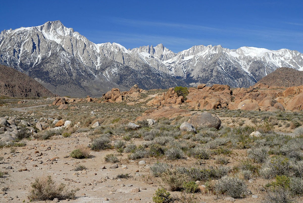
Mt Whitney is the highest peak in the lower 48, standing tall at 14,497ft, though some more recent measurements mark it at 14,508ft. It is the highpoint of the Sierra Nevada Range in eastern California and is readily seen from Route 395 east of Lone Pine. It is a shy peak, with its true height only realized as you come closer, as several other peaks seem taller from the road, some 12-15 miles distant. I took the below photo this past Spring; Whitney is the peak just to the right of center at the end of a long ridge. The Eastern Sierra is a special place.
There are several routes up this mountain, with the "Main Trail" being one of the technically easiest choices, though longer the most other routes. This is the "Mule" route as John Muir used to say. What makes this route difficult is the length and elevation gain. Otherwise, in dry weather when no snow or ice is present, the hike is largely class 1 with some very small sections of perhaps easy class 2 terrain.
Nevertheless, the trailhead elevation is 8,365ft, which yields a net difference of 6,132ft. Actual elevation gain for the hike is roughly 6,600ft when considering the ups and downs both ways. Round-trip mileage from the Whitney Portal trailhead is 22 miles. Needless to say this is a long hike. Many people do it in more than one day, choosing to camp out at one or two of the campsites on the trail up. For a longer day, you can "day hike" the mountain, which is what I opted to do.
I first climbed Mount Whitney in October 2007.
That was one of my first higher peaks to climb, and as I didn't feel well on that day and later realized I wasn't fully prepared for the trip, I always felt as though it wasn't a 'clean' climb and despite 'successfully' summiting, in my admittedly somewhat twisted mind, always felt that I'd need to climb it again to redeem myself and do it again as a one day hike as I did then. Back in 2007, including rest stops, time to deal with crampons given the packed snow on the steeper portions of the trail and time on the summit, the roundtrip climb took 17hrs. I know I had it in me to do it quicker.
I originally wanted to climb the Class 3 Mountaineers Route (after turning around on this route at 13,900ft in August 2010 due to the timing and clouds coming in). However, the weather that morning (Sept 15th) was unsettled and there had been some recent snow higher up and word had it that the conditions were slick and icy on the final two steeper exposed sections. As such, I opted to go up the "Mule Route" i.e. the Main Trail. As it was completely clouded over, but still dry by 10:00am this morning watching the summit from the Ranger Station, I figured that 10:00am would be a good target time to be at and then off the summit.
I quickly drove up to Bishop where I was staying and geared up for the morning. Bishop was about 70 miles from the trailhead, but as I was almost expecting NOT to get a permit, I was planning a backup climb further north, hence my stay there. Otherwise, I would have slept near or at the trailhead to better acclimate.
My alarm went off at 1:00AM after an all too short restless sleep, quickly ate, packed up and drove down to the trailhead. I hit the trail at 2:40AM. Not sure of what the conditions were higher up, I packed my crampons just in case.
You can't miss the trailhead, even in the dark (though I took this shot afterwards)
The weather was brisk though not super cold, maybe in the 30s lower down, colder as I ascended. I was soon hiking up in two thin layers, gloves and hat; pretty comfortable if I kept moving.
Under a waning gibbous moon and disturbingly cloudy skies, I continued up the trail into the darkness. I eventually passed occasional groups of two that had started earlier. Bear scat appeared on the trail a few times before 10,000ft. I could tell the local bruins had been eating berries. Despite the cold, my headlamp proved to be an effective magnet for any moth flying in the southern Sierra this morning. One darkish, really large moth (or really small bat) flew past occasionally, as if testing its aerial precision to see how close it could get to my head without hitting it.
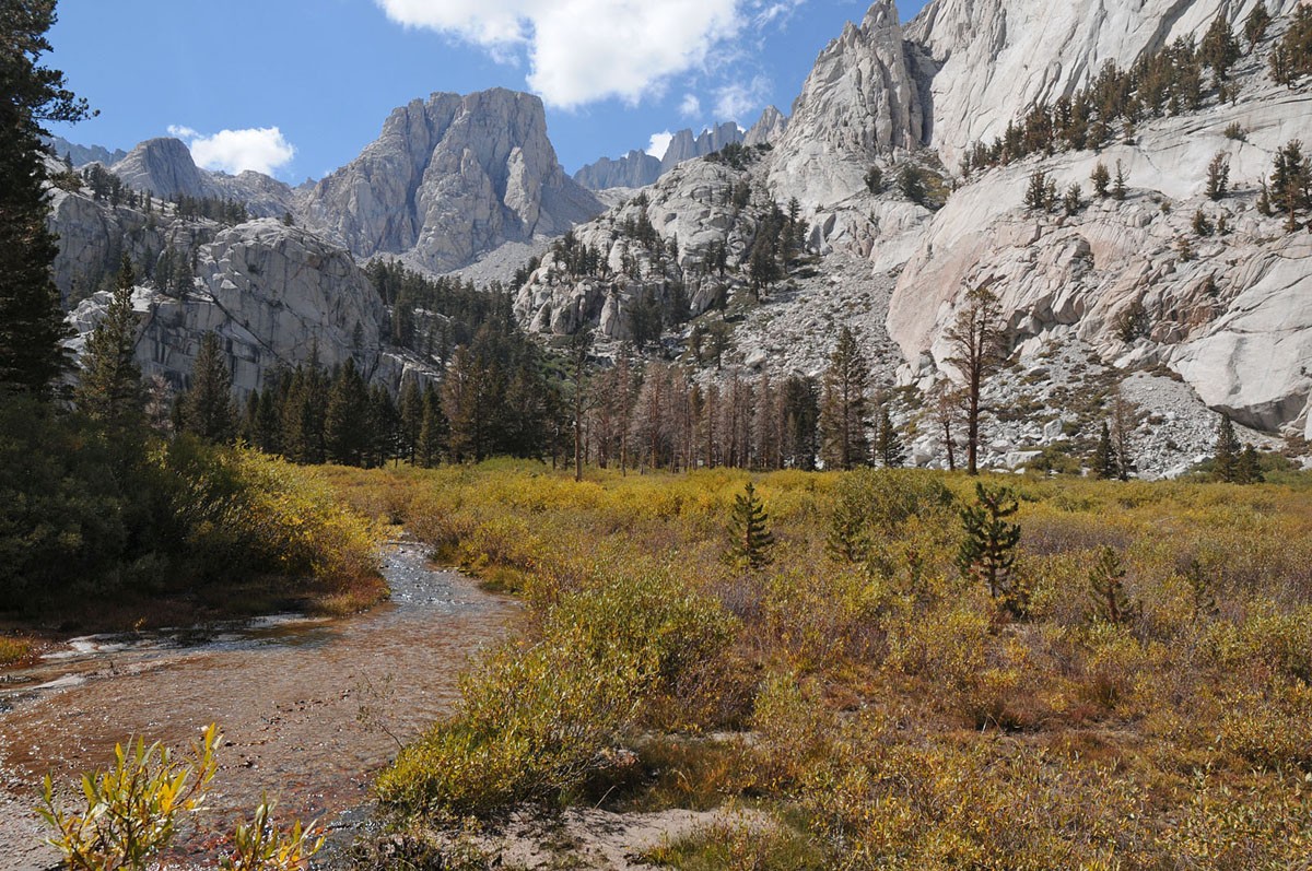
The few stream crossings had good running water but were uneventful and easy to get over and were not iced over yet.
As I climbed up, I was surrounded by towering, thousand foot granite walls illuminated in the pale moonlight, with periodic cloud cover providing additional effect. Stopping on the trail, I was met with pure silence. Aside from an occasional shrill of an owl, the forest was devoid of wind or any other movement. The scene was surreal. What a welcome change from Manhattan at night..
Soon, I passed "Outpost Camp" situated at approximately 10,400ft, where there were more than a dozen tents here this morning from what I could see, maybe more further off into the darkness beyond the reach of my headlamp. This is the low camp on the Main Trail, the first of two camping spots on this route. Many folks spend two nights on the mountain, one here and one higher up, summiting on day three. I was careful not to make too much noise or shine my light on any tents directly, though was also alert for any bears patrolling the area, given the lingering smell of campfires I noticed. I moved like a ninja, silently through the campsite; my Sensei had trained me well.
I felt I was making good time, despite not being able to acclimatize how I would have liked. My recent climbs in the Elks and Sangres in Colorado helped in this regard though and I felt solid as I started out.
As I remembered, the trail is fairly easy to follow in most places though there are some areas where some though is needed to make sure you head the right way, especially in the dark.
Orion stood watch from the night sky above as I climbed up, as if guiding me up the trail.
Upon hiking a bit more than six miles up and reaching 12,000ft, the eastern sky behind me started to take on a soft glow as false dawn was approaching. I noticed that the earlier clouds that covered the skies were now dissipating to reveal clear dark blue, still starlit skies.
I was soon at Trail Camp where I'd find a couple of small lakes from which to filter some water to refill my bottles for the remaining climb up. Several people were camped out here, as this is the high camp for the Main Trail. As I stopped here, the cold became evident and soon chilled me to the bone, especially as I dunked my bottles and hands into the cold lake.
After several minutes, the sky started to turn shades or reds and orange. Looking west, the Sierra Crest was bathed in a warm alpenglow transforming the rocky walls from a dull predawn grey to stunning hues of orange and pale red, reflecting in the lake. The moon was still visible overhead. I was standing in a panoramic photo which no camera could ever capture. The colors disappeared as quickly as they appeared.
I finished filling my water bottles, snapped some shots, inhaled a Powerbar and started hiking up towards the infamous switchbacks towards Trail Crest.
Trail Crest is a false summit of sorts where the switchbacks top out at and near where both the entrance to Sequoia National Park appears and where the intersection to the John Muir Trail is located. Whitney's summit is technically located in Sequoia National Park. This was definitely a cool way to enter the park, compared to driving in from the tourist entrance on the west side as I've previously done! Along much of the route above treeline, the land up here is similar to walking through a stunning lunar landscape.
The switchback section above Trail Camp is the crux of this route. Although the switchbacks are not technically difficult at all, this is where you'll see how effective your cardio training has been as there are 99 of them gaining roughly 1,600+ft. Due to the recent precipitation and cold temperatures, about half way up, ice covered many of the rocks today, though was generally easy to circumvent. Water was still flowing down a few of them.
In the scree and talus along the turns and slopes throughout this sections, chirps of pika and marmot were frequently heard, though not often seen.
Shortly before reaching Trail Crest, there is a slightly exposed section bounded by poles and steel cables to help you walk across in the event that ice and packed snow are present which often collects here due to its northern exposure. This area is appropriately known as the cables section, though not as precarious as the section bearing the same name on Half Dome in Yosemite. Although today the conditions were not bad, a fall here could end your trip and your life.
Views from this area and from Trail Crest are just wonderful from any direction.
Vistas of classic alpine Sierra landscape fill every angle. Looking down, you can see Trail Camp from here.
Once you reach Trail Crest at about 13,700ft, continue west where you must now give up some of that hard earned vertical gain on the west side and descend a few hundred feet before picking up the route again going up towards the last 1.9 miles to the summit. In the photo below, the summit if off to the right of that distant snowfield.
Owing in part to its elevation at or above 14,000ft and given the amount that you've climbed and distance you've hiked already, this is one of the longest 1.9 mile (3.8mi round-trip) stretches you will ever walk, especially if glazed over in ice and snow or if you're low on water.
Once you reach the junction for the John Muir Trail, turn right (north) and begin the final long gentle ascending traverse to the summit. The views off to the south and west here are wonderful.
Pay attention here; it's not hard to see, but make a sharp right to the summit (which ascends) A few people I noticed, didn't pay attention to the sign and were continuing DOWN into the valley on the southwest side of the mountain by mistake towards Guitar Lake (people who didn't come up that way). If you made this error, this would be awful as you would have to then regain an additional 3,000+ feet to get back to here to then still have to go back to the Portal trailhead (or continue to summit). In a whiteout I suppose this would be an easier mistake to make if you're not familiar with the route. Views abound near this section as you can now see on the other side of Whitney.
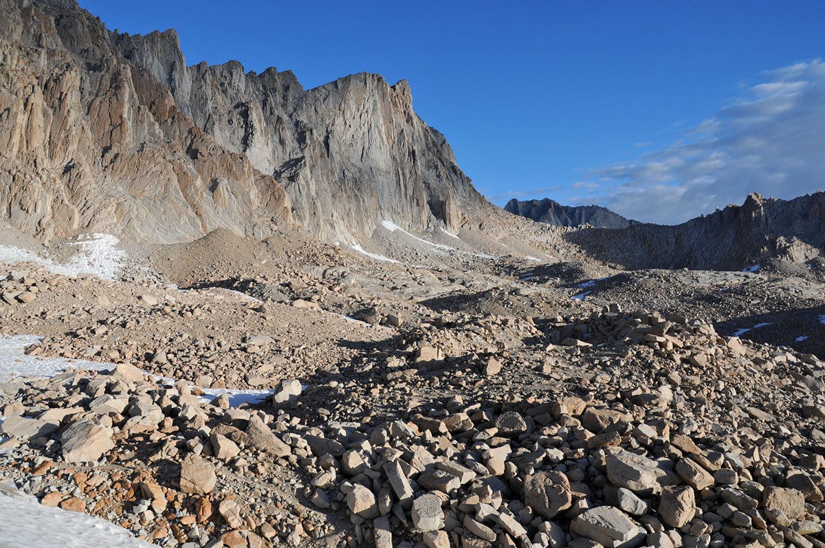
The remaining section was fairly straightforward. There was some snow and ice immediately after Trail Crest on the west side, which took some care to walk across in the early morning before the afternoon sun hit it. The Intimidating east face of Whitney is seen here through one of the "windows"
As this section doesn't receive much light, it will likely stay icy longer and likely be this way until next summer. Looking back, you can see Keeler Needle.
Further on under the last flatter section to the summit, there is a larger snowfield that must be crossed, but today there was a clean well-traveled path through it.
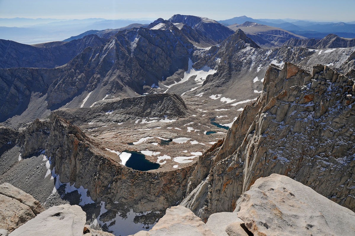
After a bit more vertical over the next quarter of a mile, you are soon on the summit, standing on top of the lower 48 states.
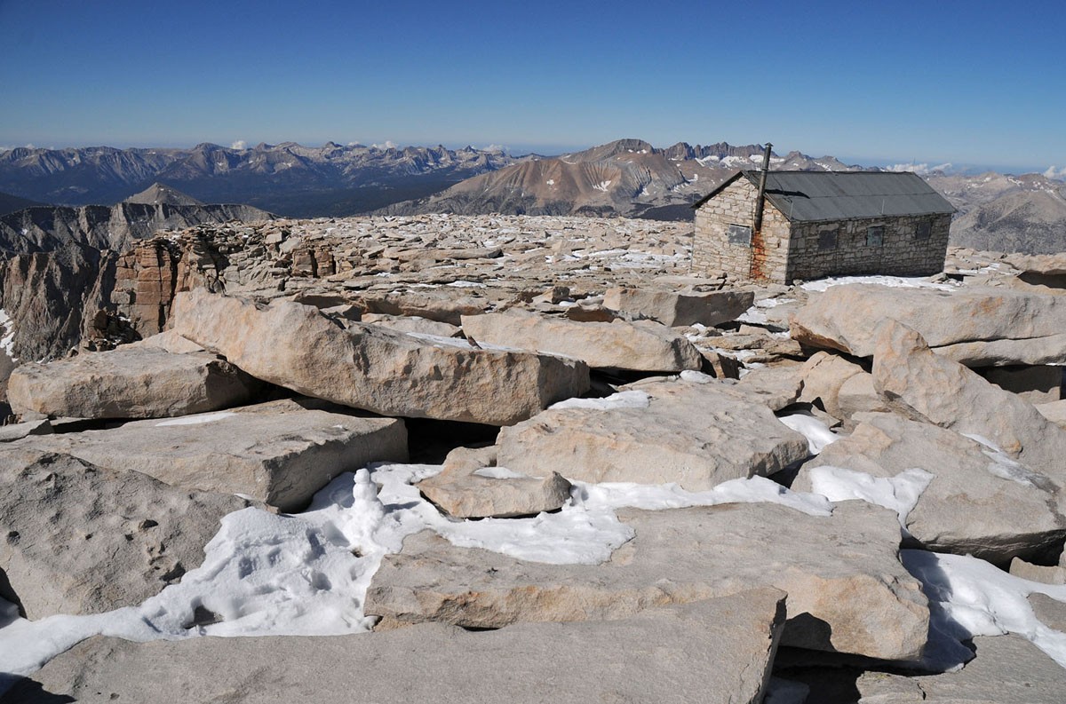
I arrived on top at 10:10AM; 7.5 hours from that start. Skies were blue, clear and calm. The summit is rather large, befitting for the tallest peak in the contiguous lower states and gradually sloping from the west, reaching steep, jagged cliffs in the east. However, I can never get used to seeing a stone cabin on top though.
Nonetheless, this structure was an amazing feat of ambition and manpower to construct. It was constructed in 1909 by Gustave Marsh for the Smithsonian and was built for scientific observation. Gustave also worked on and completed the first defined trail to the summit a few years earlier.
After admiring the shelter again, and eating my mandatory Summit Snickers, I started down. The hike down came quickly and I felt full of energy even jogging most of the easy sections.
In the daylight coming back, you can see the stunning views filled with forests of ponderosa pine and other conifers, surrounded by steep granite walls, verdant valleys and lakes colored various shades of teal and blues.
I got back to my car a bit after 3:00pm for a total time of approximately 12.5 hours. Famished as I was, I went into the Portal Store and inhaled one of the famous Burgers to recoup some of the several thousand calories I burned today!
For those looking to climb Whitney, look into the permit process and follow the weather closely in the days before your trip. Although routefinding in good weather is not hard, if the weather turns while you are climbing, you are a long way from anywhere up there.
All in all, it was a awesome climb with solid weather on a beautiful autumn-like morning.
Thumbnails for uploaded photos (click to open slideshow):
Brings back lots of great memories. 9/21/2011 2:52pm
Thanks for posting.
My all time favorite mountain.
The Lancaster/Palmdale High School cross country teams could often be seen on that trail. Tough kids. I wasn't one of them.
Pat
Thanks for the report and photos. I was there last month. 2 friends were doing the JMT north to south (a 3rd joined them at Vermillion) and I joined them at Onion Valley. We spent a week on the JMT before Whitney. We camped the night before near the ponds above guitar lake shown in your photos. We had a wicked T-storm the afternoon before with accumulating hail, but the summit weather good. We summitted at sunrise with allot of broken clouds around. There was no snow then. I plan to do a trip report if/when I can get to it. Thanks again.
Great TR, nyker, with some spectacular photos to boot! This is one of my favorite climbs of all time. I agree that it adds some unforgettable spice to the mix to include the Class 4 ascent of the West Face of Muir. Reading your TR and savoring your photos makes me long to return to the Whitney, where the granite is pure and solid and the views go on and on forever. Keep the faith, and keep up the great climbing adventures! Onward and upward...
Congrats on a successful summit! Whitney (well, actually Langley a few days earlier) was my first 14er, and I was suitably wowed. I too have to go back for Muir (and Russell, and North Pal, and...) at some point :)
Nyker, your report and pictures really catch the flavor of the Mt. Whitney trail. You're a fast hiker, too, making the ascent in 7.5 hours requires being in decent aerobic condition.
One advantage folks from Colorado have over the CA hikers is the fact most live around 5k elevation. It turns out that gives most enough acclimation so the altitude of a 14er doesn't bother them. A majority of the lowlanders here need to spend several days and nights at or above 8k so they aren't clobbered at 14k.
Caution: The information contained in this report may not be accurate and should not be the only resource used in preparation for your climb. Failure to have the necessary experience, physical conditioning, supplies or equipment can result in injury or death. 14ers.com and the author(s) of this report provide no warranties, either express or implied, that the information provided is accurate or reliable. By using the information provided, you agree to indemnify and hold harmless 14ers.com and the report author(s) with respect to any claims and demands against them, including any attorney fees and expenses. Please read the 14ers.com Safety and Disclaimer pages for more information.
Please respect private property: 14ers.com supports the rights of private landowners to determine how and by whom their land will be used. In Colorado, it is your responsibility to determine if land is private and to obtain the appropriate permission before entering the property.


")
")
")
")
")
")
")
")
")
")
")
")
")
")
")
")
")
")
")
")
")
")
")
")
")
")
")
")
")
")


