| Report Type | Full |
| Peak(s) |
Crestone Peak - 14,299 feet Crestone Needle - 14,196 feet |
| Date Posted | 09/13/2012 |
| Date Climbed | 09/11/2012 |
| Author | Wentzl |
| Peak to Needle via Cottonwood Creek |
|---|
|
This trip report will provide useful information to anyone considering using the Cottonwood Creek approach to climb the Crestones. Aside from that, I will not provide much information about the traverse, which is extensively covered in other reports. I will ramble on a bit more than usual to tell what might have turned into more of an epic, but turned out to be one of those precious moments when the mountain dieties choose to smile rather than smite. We started up Cottonwood Creek, which is about 10 miles south of the town of Crestone. We didn't get started till 8:30 a.m., didn't think to bring headlamps and spent 11 1/2 hours on the mountain. Do the math. We just barely avoided an unplanned night out, but that gets ahead of the story. Access issues appear to have been settled. There is a port-o-john, sign in register and plenty of parking for 20 cars or more. The first two miles have had extensive work recently and downfall across the trail has been cleared. After that things are still interesting. There are some exposed rock sections which are very slippery when wet. On the way up we wondered how hard it would be to get down safely in the rain. Later that night we would discover that with the careful use of glutomus maximus friction a wet ass can make a pretty good self arresting device. Shortly after the exposed rock you reach treeline and the trail pretty much disappears. If you want to stay on the trail the trick is to follow the cairns that lead you up over the rubbly rock pile and then just as quick as you got up start descending again through the rocks back to the creek. It looks like you are walking to the bottom of a cliff that will bar passage. However, there is a steep, wet muddy scramble that will require hauling yourself up with tree limbs at times. This is not a casual trail. Our plan was to get to Cottonwood Lake, just below Broken Hand Pass, climb the Needle and traverse to the Peak and descend the Peak South Face route back to Cottonwood Creek. Because we lost the trail we contoured up into the upper basin and found ourselves far North of Cottonwood Lake and just under the South Face route of Crestone Peak. We changed the plan and reversed the traverse, now intending to go from the Peak to the Needle. It actually wasn't a bad detour and worked out in our favor. In retrospect I actually recommend this variation as a better way to do the traverse from Cottonwood Creek. This first photo will show where we left the main trail. On the descent, we found and followed the trail through the cliff barrier near the creek. It was all there, but there are some tight muddy steep and not at all obvious decisions to make. In many places the trail looks like little more than a game trail, but there were frequent cairns. 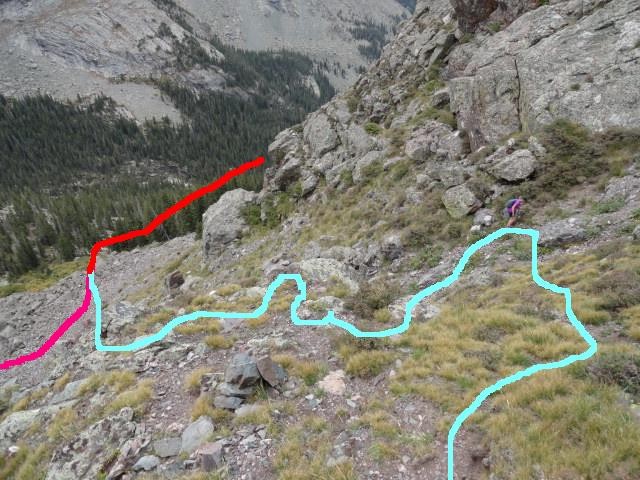 After we left the trail and gained about 350 vertical feet we could begin a contouring ascent toward the base of the red gully in the South Face route on the Peak. This turned out to be easier than it looked and we intersected the trail coming from Broken Hand Pass to the South Face route with very little loss in elevation and only minutes from the actual start of the climb. I do recommend this for anyone wanting to do the traverse Peak to Needle from the Cottonwood side. In the next image I show the view of the basin below the Crestone Traverse. Oddly, we never did see Cottonwood Lake, from any of these vantage points. It was not until descending the Needle that we finally saw the lake. In the photo the (1) shows Broken Hand Pass, then an arrow to the approximate location of the lake, (2) shows Crestone Needle and then the Black Gendarme and (3) is the approximate location of the south face route and the Peak summit just offscreen. 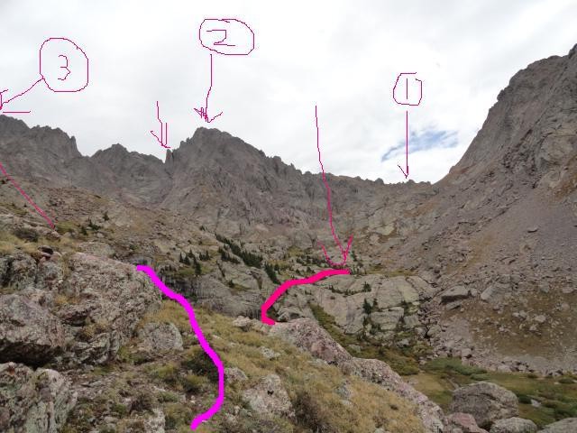 That is all of the useful information. The rest of this report is just an indulgence in telling a fun story EXCEPT for an important note about the descent of the Needle via the South Face that first timers should consider. The hike up Crestone Peak was fun, but long. The next couple images show some scrambling in the lower part of the red gully on the South Face route. 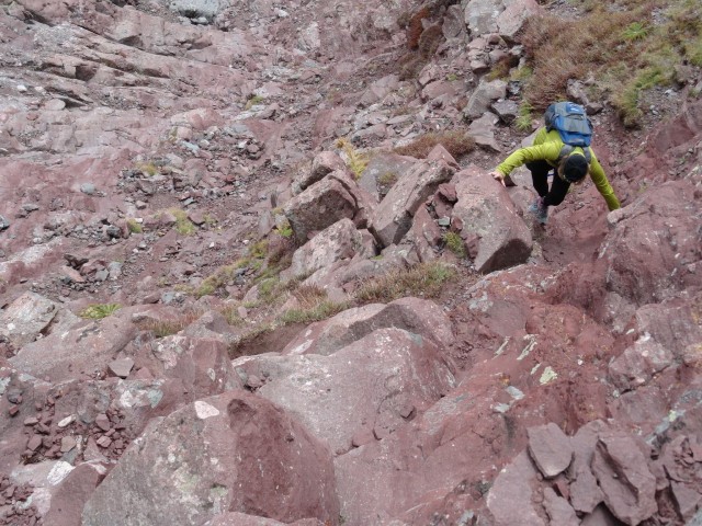 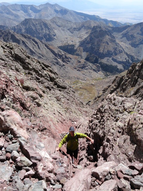 It was almost 2:00 by the time we reached the summit. 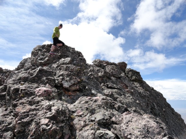 Despite the hour we decided to press on with our intended, albeit altered plan for the day. The traverse lured us on. The image of the Needle from the summit of the Peak. 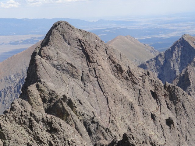 This was my third time on the traverse and I knew we were pressing our luck but conisdered the worst that could happen would be an unplanned night camped below treeline. About 2 hours later, most of the traverse behind us the weather rolled in. We hunkered down in a conveniently placed cave while the fog, rain, snow and sleet did it's thing. Retreat from this point on the mountain was uncertain. Reversing some of the moves on the traverse on rainslicked rock would be tricky. We considered, and began to descend a gully which would have required over 1,000' of uncertainty about being cliffed out and stuck. If anyone has experience bailing from mid-way through the traverse I would like to hear how that worked out. We looked carefully at the gully adjacent to the SW ridge of the Needle. Please contact me if have experience playing in this area In fact, this was our choice as the best option after 30 minutes of waiting in the cave. As soon as we started down the sun came out, as if to say, no no, don't go that way, here is the chance to finish that you have been waiting for. We were both tired and for a while believed that the quick descent was the best option. Despite the break in the weather we started down on some slick technical climbing, Elly leading the way. I balked, my gut a little twisted by contmplating so much unknown terrain so high up on the mountain. The sun was now shining brightly, the rocks already starting to dry and the crux 100' of class 4 climbing to the summit less than 30 minutes away, I made up my mind that it would be safer, and more satisfying to finish the climb and descend the South Face of the Needle, which I had done twice before, last year in the rain. Elly agreed with the sudden change in plans (a theme for the day) and in nice weather we made the summit of the Needle without incident. The final pitch to the summit of the Needle 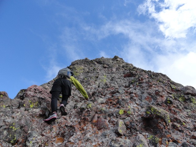 A look over at Humboldt Peak from just below the crux on the Needle 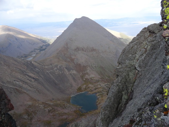 The view back at the Peak from the Needle 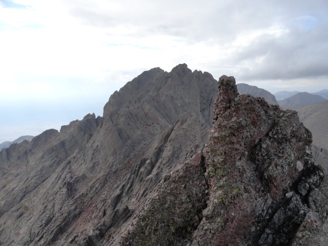 Summit of the Needle 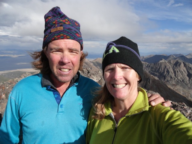 So here we were at 5:00 p.m., over 14,000' feet high, clouds building anew, this time with thunder nearby. We were approximately six miles from the car, pretty beat up from the day, and contemplating a long semi technical descent. We could easily see the trail passing by Cottonwood Lake. We knew that the Cottonwood Creek trail branched off somewhere sooner than where we had intersected it in the morning. Going back the way we came would mean gaining and losing several hundred vertical feet and add another mile to the trip. We had to find the junction with the poorly maintained Cottonwood Creek trail. I am trying to remember, did it get dark last night at 7 or at 8? I can't really remember. I am usually pretty attuned to these details but somehow I am suddenly unsure whether we have 2 hours to get out or three. Well, nothing to do about it now but enjoy the view and get going. The next couple photos are about 1/2 way down the South Face of the Needle, first looking up and then down from the same spot. The crack in the middle of the first photo shows the descent line. 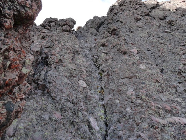 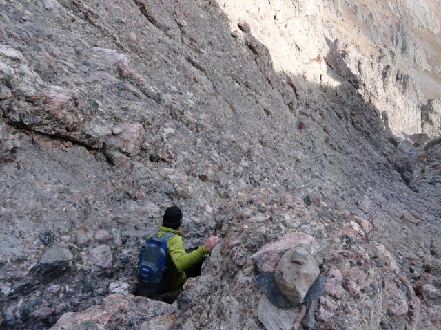 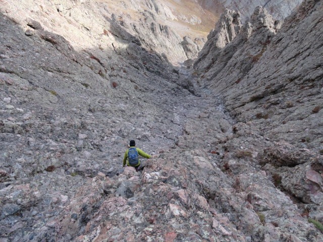 The next bit is important * * * In the previous photo it shows where it is imperative that you exit the gully to the east (the left if descending face out) and access Broken Hand Pass. If your descent off the Needle is your first exposure to this part of the mountain it would be easy to continue to descend too far in the gully. Last year there was a fatality here when someone made this mistake! * * * After the descent to the Cottonwood lake the fog moved in and was hiding the summit and everything else 100' or higher over our head. If the fog dropped to the valley floor and obscured the view it would be very difficult find our way out. We did not find the juncture with the Cottonwood Creek trail that we anticipated. Instead we began to climb back up the drainage and back to the start of the South Face route on Crestone Peak. If we kept on we would just go in an enormous circle. The route we took in the morning simply followed the contour of the valley a couple hundred feet higher than where we were. That was also in the fog now. There was no going back the way we came. Nothing to do but bushwack, follow a small feeder creek to Cottonwood Creek and hope to pick up the trail we missed in the morning. It was now after 6:00 p.m. While we did make pretty good time from the summit, I am now thinking seriously about where we will spend the night. The bushwacking was amazingly straightforward. We followed the feeder creek over small cliffs, busting through waist high alders, soaked with rain and picking up animal trails where we could. Despite sucking mud, slick moss covered rocks, thick brush and very uneven undulating terrain we moved deliberately and with energy and purpose. We hardly noticed the now persistent rain. It was actually only 15 minutes before we started spotting cairns and the animal trails merged with what turned out to be the trail we wanted. Amazingly obscure and following a most unlikely path to get past the 200' barrier cliff, which we intentionally avoided in the morning on the way up because it looked so impractical, we managed to rejoin familiar terrain by 6:30 p.m. 4 miles to go. 7:15. The light is holding pretty good. 2 miles to go. Oh yeah, now we are just about to the point where I noticed the hole in my pocket and the fact that I did not have a car key. I noticed this on the way up but didn't want to ruin the trip to go looking for the key. Anyway, last week someone had their car broken into at this trailhead by a bear looking for food and I had spare keys in the car so maybe I won't have to break a window. It is getting hard to see when we are in the trees. 7:45 Pretty dark now, starting to wander off the trail occasionally. Part sight, part feel to stay on the path, but less than a mile to go. Back at the car at 8:00. It is dark now. The car was not attacked by bears. I go to open the door just in case I forgot to lock it and the "lost" key is in the door. While we are changing and getting settled there is one amazingly bright flash of lightening, like when it is so close you can smell it, but no thunder. Not a sound. Not a distant rumble, nothing but dead silence. It is a surreal moment in which to contemplate a spectacular day. Now I know I had that key in my pocket. I remember intentionally checking that the door was locked in the morning and feeling the key in my pocket when we set off. If you hiked up the trail, found a key and stuck it in the door of a white Carmy, thank you. It was a beautiful convergence of luck and skill that allowed us safe passage to enjoy an interesting and satisfying mountain experience. Thumbnails for uploaded photos (click to open slideshow): ")
")
")
")
")
")
")
")
")
")
")
")
")
|
| Comments or Questions | ||||||||||||
|---|---|---|---|---|---|---|---|---|---|---|---|---|
|
Caution: The information contained in this report may not be accurate and should not be the only resource used in preparation for your climb. Failure to have the necessary experience, physical conditioning, supplies or equipment can result in injury or death. 14ers.com and the author(s) of this report provide no warranties, either express or implied, that the information provided is accurate or reliable. By using the information provided, you agree to indemnify and hold harmless 14ers.com and the report author(s) with respect to any claims and demands against them, including any attorney fees and expenses. Please read the 14ers.com Safety and Disclaimer pages for more information.
Please respect private property: 14ers.com supports the rights of private landowners to determine how and by whom their land will be used. In Colorado, it is your responsibility to determine if land is private and to obtain the appropriate permission before entering the property.


