After sending out some personal emails I was able to talk my friend Brian into joining me for the weekend of technical peaks and a little bit of adventure. We met in South Denver Friday afternoon, hopped into my Subaru and booked it down to the Sangre de Cristo mountains, bound for Lake Como Rd. We started up the first 1.5 miles of smooth dirt road no problem, though it soon turned to softball sized loose cobbles. We slowly bounced up the road, bypass a few rocky spots without issue until we finally came to the dry wash at 8800ft. Upon inspection I deemed the Forester could high side on the left (driving up toward Como) to bypass a few larger boulders on the right, and got through without issue. Within 100ft the road again pitched up, this time with more large rocks and craters, ones I did not feel driving the Subaru over, so we parked right near the dry wash and the 'black bear' sign to camp for the night. If you have a slightly higher clearance vehicle (larger SUV, Toyota Tacoma, etc) you should be able to make 10000ft with some careful driving as there are only a few problem spots, just too much for a Subaru.
We woke the next morning at the crack of 3:40am, threw together the gear, shouldered the helmets and began hiking up the Lake Como Rd at 4:03am. The road was long, rocky, and tedious, but went by quickly and at 5:50am we passed Lake Como and continued up toward the NW face of Little Bear, our first route. We left the trail around 12100ft and headed toward the black stain at the base of the NW face. The headwall just right of the black stain was our first obstacle, but we were able to surmount it with just some easy class 4 scrambling and soon found ourselves climbing up the ribs and gulleys of the NW face. After a few 100ft we traversed left into a larger bowl and the main gulley on the NW face that takes one to Little Bear. The climbing was mostly solid and very continuous as we ascended a mix of class 3-4 terrain, which was complicated by the fact that heavy rains the previous night had made all the rock and lichen a little damp. As we neared the top we took a leftward ascending route that eventually popped us out on the Little Bear-Blanca traverse ridge, 3 small towers from the summit. There was no easy route up from here, over one tower, then around the crux tower across the class 5 move, which was damp from the previous night's graupel and rain making it all kinds of sketchy. After tip-toeing around the ledges, we finally topped out on Little Bear at 7:30am.
We sat and pondered our fate for a few minutes, finally deciding that the wet rock on the ridge traverse was uncomfortable enough to make it a "No Go" today, so down the Hourglass we went. We carefully hopped down the rubble filled slopes at the top, reaching the Hourglass proper where we scrambled down rocks on climbers left to avoid the strong flow of water coming down the couloir. We'd spoken with a party earlier in the day who said that a new rope had been placed as of 8/2/13, the shiny orange rope was in fact there. We scrambled most of the way down without use of the rope (climbers left) but finally gave in near the bottom where the couloir constricts forcing one into the flowing waterfall. The traverse back to the main road went quickly, and at 8:45am we once again turned up the dirt road, this time bound for Ellingwood and Blanca.
With our change of plans, the SW ridge of Ellingwood became the preferred ascent route, so at 12600ft we left the trail and for a dark band of rock that provided an easy direct line onto the SW ridge. The SW ridge is a very solid and fun route, with moments of exposure, rock scrambling that can be kept at class 3, though a few class 4 moves might be required if you stick to the ridge proper the entire way. We picked our way up the ridge, staying high most of the time and finally scrambled our way to the summit of Ellingwood at 10:30am. Despite the crowds on the trails below and on Blanca, we were alone atop Ellingwood, a pleasant surprise. We descended off Ellingwood via the high route, following the ridge much of the way, until we hit one tower that forced us down the gulley 50-100ft to traverse around before starting our climb back up to the ridge and toward Blanca. We slogged our way up the North face of Blanca, topping out at 11:15am, again with the summit to ourselves. As we descended the trail back down toward Lake Como low clouds began to roll in, obscuring the summits and pouring over the ridges. The long hike/run out went fairly uneventfully down the road, only interrupted by a short break to watch a highly modified jeep pick its way through Jaws (impressive), though we did beat the jeep back down to the 8800ft mark at 2:10pm. In total the modified route compiled 18miles and 9200ft, and three 14ers, leaving me with just four more peaks until I complete them (Mt Wilson, Wilson Peak, El Diente and San Luis).
Thumbnails for uploaded photos (click to open slideshow):
 Standing at the base of the NW face of Little Bear.")
 Ascending the lower portion of the NW face.")
 Scrambling the ridge back to Little Bear after topping out on the NW face.")
 Descending the Hourglass, lots o water.")
 Obvious traverse line onto Ellingwood's SW ridge.")
 Ascending Ellingwood's SW ridge.")
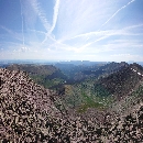
 View from Blanca toward Little Bear")
 Looking toward")
 Clouds rolling in on Ellingwood and Blanca.")
 Modified Jeep on Jaws.")
|
 Standing at the base of the NW face of Little Bear.")
 Ascending the lower portion of the NW face.")
 Scrambling the ridge back to Little Bear after topping out on the NW face.")
 Descending the Hourglass, lots o water.")
 Obvious traverse line onto Ellingwood's SW ridge.")
 Ascending Ellingwood's SW ridge.")
 View from Blanca toward Little Bear")
 Looking toward")
 Clouds rolling in on Ellingwood and Blanca.")
 Modified Jeep on Jaws.")