Crestones: Cottonwood Creek approach
Forum rules
- This is a mountaineering forum, so please keep your posts on-topic. Posts do not all have to be related to the 14ers but should at least be mountaineering-related.
- Personal attacks and confrontational behavior will result in removal from the forum at the discretion of the administrators.
- Do not use this forum to advertise, sell photos or other products or promote a commercial website.
- Posts will be removed at the discretion of the site administrator or moderator(s), including: Troll posts, posts pushing political views or religious beliefs, and posts with the purpose of instigating conflict within the forum.
For more details, please see the Terms of Use you agreed to when joining the forum.
-
AlexeyD

- Posts: 1286
- Joined: 10/28/2013
- 14ers: 44 4 2
- Trip Reports (3)
Crestones: Cottonwood Creek approach
Just curious: is there a particular reason why more people don't use this approach for doing both Crestones in one trip? Seems more logical as you don't have to cross back and forth over Broken Hand Pass a bunch of times. Am I missing something critical here?
-
highpilgrim

- Posts: 3191
- Joined: 3/14/2008
- 14ers: 58
- 13ers: 84 1
- Trip Reports (1)
Re: Crestones: Cottonwood Creek approach
It's a more difficult approach. Route finding is more challenging, there is an issue with blown down trees and parts of it are very steep. Trail junctions are also less than clear and mistakes take you up the wrong drainage.
Having said all this, it's a fine approach, very secluded and much more a wilderness experience than the SCL side.
I really enjoy the route from the west side.
Having said all this, it's a fine approach, very secluded and much more a wilderness experience than the SCL side.
I really enjoy the route from the west side.
Call on God, but row away from the rocks.
Hunter S Thompson
Walk away from the droning and leave the hive behind.
Dick Derkase
Hunter S Thompson
Walk away from the droning and leave the hive behind.
Dick Derkase
-
fahixson

- Posts: 437
- Joined: 9/11/2007
- 14ers: 57
- 13ers: 35
- Trip Reports (1)
Re: Crestones: Cottonwood Creek approach
Pilgrim pretty much covered it. None of those extra difficulties make the approach insurmountable, but certainly more difficult than SCL. I believe at one time there were also access issues for the TH, which meant less people with access to Cottonwood. So, this approach just wasn't talked about as much during that time of limited access.
Although we found it challenging, I think I would do it again some time. I'd probably call it the most difficult pack in to camp for a 14er we've done (granted, that's not a huge sample size). It took us right at 4.5 hours both coming and going to camp from TH. I forgot how long it took us to camp from SCL, but would guess it took about half that time. On the bright side, Peak from Cottonwood lake is one of the easiest summit days we've had for a 14er, and it's less than 30 minutes from Cottonwood Lake to the top of Brokenhand Pass on decent trail. That said, we are planning to use SCL when we head for Needle in August.
These threads should help you get familiar with the route finding and extra issues for Cottonwood, including good trip reports.
Hike Crestone Peak the town of Crestone?
Cottonwood Creek Waterfall Climb
Crestones via Cottonwood route questions
-
painless4u2

- Posts: 1300
- Joined: 7/14/2010
- 14ers: 58
- Trip Reports (8)
Re: Crestones: Cottonwood Creek approach
It"s a good route but pretty steady uphill all the way. When we did this route, you come to a large, rather flat open area in the trees with a misleading branch to the right. Don't take this path, but rather continue straight toward the "back" of this area, where the trail steeply continues up slope. Once you make the ridge where the lake is located, Crestone Peak is right there.
You may also encounter some interesting locals participating in various new-age(?) type activities along the way. It also makes for a very speedy return.
You may also encounter some interesting locals participating in various new-age(?) type activities along the way. It also makes for a very speedy return.
Bad decisions often make good stories.
IPAs + Ambien = "14ers" post (Bill M.)
In their hearts humans plan their course, but the Lord establishes their steps. Proverbs 16:9
IPAs + Ambien = "14ers" post (Bill M.)
In their hearts humans plan their course, but the Lord establishes their steps. Proverbs 16:9
-
Mike66

- Posts: 7
- Joined: 2/17/2015
- Trip Reports (0)
Re: Crestones: Cottonwood Creek approach
I went up the Cottonwood Creek drainage in 2011 and 2012. It's a special area with a wilderness feel to it.
If you go, you may want to remember these items.
* Secure your vehicle, place anything of value out of sight.
* Respect the Baca Water District's property and park in the appropriate space.
* The rock slabs are not that bad. Once you reach the top look for the left turn a little farther up. This takes you to some nice camping spots below the steep slopes before the waterfall.
* The route is relatively easy to follow, take your time and enjoy the place. Don't become discouraged by the fallen trees before the rock slabs. I went left and then right to rejoin the trail in 2012.
* I think the view of the wall between the Peak and Needle from the 2nd bench is really amazing.
* There is plenty of water along the trail.
* Takes some time to admire Milwaukee and Pico Asilado from this perspective. One of Pico's route uses the Cottonwood Creek approach.
I concur with the previous site members' postings. This trail and area adds something to the Peak/Needle experience. Good luck and safe hiking.
-
highpilgrim
- Posts: 3191
- Joined: 3/14/2008
- 14ers: 58
- 13ers: 84 1
- Trip Reports (1)
Re: Crestones: Cottonwood Creek approach
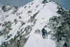
Those basins, both high and low, are very special places. I've posted this pic before but it captures the spirit of the place. Needle in the center, peak just out of view to the left.Mike66 wrote: It's a special area with a wilderness feel to it.
- c2.jpg (335.1 KiB) Viewed 4161 times
Call on God, but row away from the rocks.
Hunter S Thompson
Walk away from the droning and leave the hive behind.
Dick Derkase
Hunter S Thompson
Walk away from the droning and leave the hive behind.
Dick Derkase
-
jdorje

- Posts: 1387
- Joined: 6/16/2010
- 14ers: 12
- 13ers: 27
- Trip Reports (16)
Re: Crestones: Cottonwood Creek approach
Camping at cottonwood lake is excellent and gives a very short day to climb one or both peaks.
But the trail to cottonwood...god. The one time I camped there, it was a 4.5 hour pack in. The times I've day hiked to the lake, it inevitably takes 3+ hours and I get lost at a new spot every time. I haven't even made the most common mistake, which is continuing up the wrong trail to Milwaukee pass. The canyon is so steep that GPS is of limited use, the trail isn't marked correctly on maps anyway, and, well. It's work.
* Low down there is intermittent deadfall that caused us to lose the trail repeatedly. This was particularly worse on the downhill section for whatever reason. I think this deadfall has been cleared though as I had no trouble with this section last year.
* A bit further up there's a big rock cliff and the trail isn't clear if it goes left or right. Actually if you look closely there are cairns, but I have missed those at least twice and gone left. Sticking to the right, close to the creek, you can follow cairns and an steep trail up through rocks past a waterfall.
* Then you get to the creek split area. GPS helps here.
* Above the creek split area the trail crosses the creek several times and goes along rocks ("boilerplate slabs"...really annoying if wet or icy), loops around, does complicated things. In one section a landslide appears to have covered the original trail, and there's a talus-hopping section to loop over the landslide. But it's pretty well cairned in this area.
* Then you get to the waterfall, in High pilgrim's picture. The actual trail goes up almost underneath the waterfall (poorly marked heading uphill, easy to find coming downhill) then goes up a steep and narrow gully. Pretty easy but with a large pack it could be hard to fit; still this is the way I'd recommend. Another alternative is to follow a system of ledges just left of the waterfall; these have some cairns on them...I've never gone that route. If you go up to the right or left of the waterfall all the way around the headwall it's pretty easy terrain but a lot of wasted elevation as you then probably want to descend to the trail again...of the two the left is probably easier.
* Above the waterfall the trail is intermittent. It goes through willows and there are misleading branches. Every now and then you can see a cairn in the distance and try to make for it. This is basically above treeline though and losing the trail isn't the end of the world.
With a trailhead at 8400 feet, I'm pretty sure it's "faster" to hike both peaks from the SCL trailhead even with the extra ascent to regain BHP.
"I don't think about the past, and the future is a mystery. Only the present matters."
Re: Crestones: Cottonwood Creek approach
Skied near pico asilado about 6 weeks ago- the trail was in great shape all the way to the slabs, with all downed trees cut out and moved from the trail. Not as bad as I remembered it, that's for sure.

Re: Crestones: Cottonwood Creek approach
Id be curious if anyone has the GPS points listed for this approach? Maybe Bill could add them to the route description. I think that would be pretty helpful.
“The best climber in the world is the one who is having all the fun.” – Alex Lowe
" Don’t be afraid to move out of your comfort zone. Some of your best life experiences and opportunities will transpire only after you dare to loose."
" Don’t be afraid to move out of your comfort zone. Some of your best life experiences and opportunities will transpire only after you dare to loose."
-
fahixson
- Posts: 437
- Joined: 9/11/2007
- 14ers: 57
- 13ers: 35
- Trip Reports (1)
Re: Crestones: Cottonwood Creek approach
We didn't have a stand alone GPS, but reviewed these TRs below ahead of our trip. Some include topo maps with their route depicted and one ("Peak to Needle traverse from Cottonwood Creek TH" from SnowAlien) includes a gpx available for download. From those, we marked a few waypoints on a phone GPS to help us along the way. Given more recent usage over the past few years and clearing of most of the downed trees, I don't think the trail is all that difficult to follow. It's just difficult because it's a ways to travel and good bit of elevation gain compared to other 14er pack ins.kushrocks wrote:Id be curious if anyone has the GPS points listed for this approach? Maybe Bill could add them to the route description. I think that would be pretty helpful.
Cottonwood to Crestones
Perfect Day to Finish the 14ers
Peak to Needle via Cottonwood Creek
Carrying the Torch
Peak to Needle Traverse from Cottonwood Creek TH
Peak and Needle via Cottonwood Trail
Crestone Needle and Peak via Cottonwood Creek
Crestone Peak via Cottonwood Creek
Crestone Peak via Cottonwood Creek Trailhead
-
rockyalps

- Posts: 19
- Joined: 12/5/2006
- 14ers: 5
- 13ers: 1
- Trip Reports (0)
Re: Crestones: Cottonwood Creek approach
If doing one of the Crestones as a day hike using the Cottonwood Creek approach (either Crestone Peak or Crestone Needle, but not both), is there a good comparison out there of another 14er that takes about the same amount of effort, taking into account not just the mileage, elevation gain, and scrambling, but also potential route-finding difficulties on the trail lower down? I'd like to do one of them sometime, most likely the Needle, and with only a 2WD vehicle I'm not interested in walking all the way up the SCL road.
-
atalarico

- Posts: 542
- Joined: 9/20/2009
- 14ers: 16 2
- 13ers: 22
- Trip Reports (5)
Re: Crestones: Cottonwood Creek approach
Anyone have any recent conditions on the CC approach? I climbed Crestone a couple years ago in October (?) from SCL, and had just about the longest day in the mountains of my life (only to be surpassed by a car-to-car of the Grand this past summer). I remember gazing down the Cottonwood Creek valley from the Summer thinking "Hmmmm...that sure looks a lot closer".
I'm mildly curious about using this TH this summer and it seems like it's a bit more used these days (good and bad). Anyway, thanks!
I'm mildly curious about using this TH this summer and it seems like it's a bit more used these days (good and bad). Anyway, thanks!

