Hagerman Peak
SouthfaceDifficulty Difficult Class 2
Snow Steepness: Moderate
Snow Steepness: Moderate
TrailheadLead King Basin
Start9,660 feet
Summit13,848 feet
Total Gain4,358 ft
RT Length10 mi
Authordksmith
Last UpdatedMar 2021
Camping Reservation Required
Snow Only Route
Trailhead
From Carbondale, drive 21.5 miles south on CO 133. Turn left on Gunnison County Road 3 toward the town of Marble (this road may be labeled as FR 314 on some maps). Measure the mileage from here:
- Drive 5.5 miles to the center of Marble and continue through the town.
- Pass a church at 5.8 mi. and Beaver Lake at 6.2 mi.
- At 7.0 miles, the road becomes rough.
- At 7.7 miles, there is a junction. Turn left on FR 315 (Lost Trail Road) for Lead King Basin.
- The remaining 6+ miles is rough and narrow. 4wd vehicles only.
- At 9.7 miles, there is another junction. Stay left on FR 315.
- After a long drive with many switchbacks, cross a small stream to reach a corner at 13.8 miles.
- Continue a bit farther south down the road and cross the creek again to reach the actual trailhead, shortly after. The trail starts on the east side of the road, in the parking area.
Route
Road Access Option 2: Crystal to Lead King Trailhead (Crystal River Road)
This access road is more difficult driving than the Lost Trail Creek Road. The Lost Creek Road is typically the standard road access route into the Lead King Trailhead
At the junction at 7.7 miles the road is signed to the town of Crystal heading to the right. This section of road to Crystal is rocky and rough but should be able to be driven by standard SUV vehicles. Beginning at Crystal and continuing up to the Lead King Trailhead is a very rough, rocky and with rock ledges section to the road. It is 2.2 miles from Crystal to the Lead King Basin trailhead. A short wheel base 4x4 with good driving skills is required to negotiate this section.
Directly beyond Crystal are two switch backs that lead to the junction with FS 317. Directly below the junction with FS 317 is one large rocky boulder ledge in the road that is difficult to negotiate. Driving this section will give you a good feel for what the rest of the road is like. The road junction would be a good place to turn around if you are uncomfortable with the driving conditions. The road beyond the junction is actually a bit rougher with approximately half a dozen other rocky ledge sections to negotiate. The Nissan Xterra with side step rails did not fair to well and bent the rails up a bit while driving down this 2 mile section.
Route: South Face
________________________________________________________________________
Note: I climbed this route (South Face) in Aug 2020 and had not planned to prepare a route description write up. I did not take the camera along so I have poached photos from other climber's trip reports to help illustrate the South Face route (Class 2+) which appears to be the route most frequently climbed. From reading other reports the second most commonly used route from the west appears to be the Southwest Ridge (Class 3). It is shown on the map but not described here.
The South Face route has a lot of loose rock on it. Much of the rock is softball to football sized making it a trudge to ascend the upper portions of the South Face route. Perhaps climbing the route earlier in the summer when the upper portion still has some snow on the route would make it a bit more pleasant.
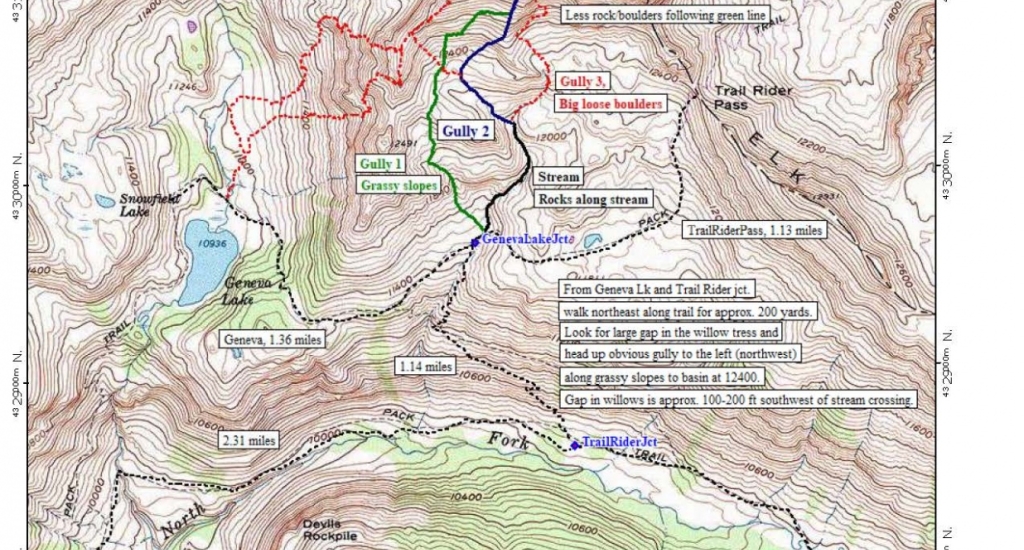
Starting point is the Lead King trail head parking area at 9660 ft. Refer to the map 1 of the area for additional clarification. The trail leaves from the north end of the parking area. The goal is to get to the Geneva Lake/Trailrider Pass trail junction sign located at approximately 11,500 ft. (show as GenevaLakeJct on the map). There are three hiking options to get to the trail junction sign and the start of the off trail climbing.
- Option 1 - Hike the trail system along the North Fork of Crystal River to the Geneva Lake Jct.
- Option 2 - Hike the trail system up to Geneva Lake. Pass along the west then northwest side of the lake to reach the Geneva Lake Jct
- Option 3 - Approach from Snowmass Creek, cross over Trail Rider pass and descend to the Geneva Lake Jct all along existing trails.
Option 1 and 2 are approximately the same length and elevation gain with Option 1 being about 1/4 mile shorter and a slightly less elevation gain (approx. 200 ft).
Option 1 description: (This the intended route you are aiming for)
Proceed north from the trail head 0.6 miles to a signed trail junction. The left (west) trail leads to Geneva Lake. Go right (continuing north) for approximately 0.2 miles where you will reach a gully and a stream crossing. The stream crossing has an old abutment next to it but no bridge. Easily cross the stream on some logs (may be more difficult with spring runoff) and continue along the trail in an easterly direction following along the North Fork of the Cyrstal River. At 1.7 miles from the first Geneva Lake junction you will reach another signed junction indicating Trail Rider Pass and Geneva Lake. There are various campsites around this junction. Turn left (northwest) and head up the moderately steep trail with switchbacks. Note: USGS maps and other sources show the ascending trail traverse of the slope to be further to the east which is incorrect. This trail segment is 1.1 miles long and takes you to the Geneva Lake Jct sign 2 and the beginning of the climb. As you approach the trail junction at 11,500 ft look to the northwest and observe the grassy gully above the willows. This the intended route you are aiming for. It is labeled Gully 1 on the map 1. Proceed across the stream (dry late in the year) along the Trail Rider Pass trail. You will travel along this trail for approximately 200-300 yards looking for a 20 foot gap in the willows on you left (northwest). If you get to the second stream crossing you have passed the willow gap by about 100 feet. The willows look thick but if you find the correct gap you will be able to navigate easily through the willows following the additional gaps that will present themselves as you navigate uphill from the trail. Note: The second stream crossing is the beginning of Roach's climbing route description and is noted as Gully 2 (black and blue lines) on the map. The lower section of this route passes along the stream which and then continues up through some grassy and rock sections to the west basin at 12,200 ft 4. It is a bit rougher footing than Gully 1, especially coming back down after ascending the peak.
As you reach the upper reaches of the willows the gully (Gully 1) will open up to grassy slopes 3. As you ascend this gully, look for a spot to cross the entrenched gully bottom. Facing uphill you want to cross over to the right hand side (northeast) side of the gully as shown in 3 and work your way up the steepening slope to what looks like a small saddle on the right in the upper reaches of the gully. At the top of the gully, bear slightly right along the grassy areas avoiding any rock hopping and you will arrive in the west basin at 12,200 ft. Once in the basin you will have a good view of the South Face and the remaining portion of the route. Photos 5 and 6 are high on the route looking down into the basin showing the upper reaches of the Gully 1 approach and the beginning of the ascending traverse through the basin. 7 is slightly above and to the right of the exit point of Gully 1 and also above the Gully 2 approach. It depicts the ascending traverse but with snow on the route. Your goal from here is to follow an ascending traverse northeast around the basin to join the base of the ascent gully on the east side of the basin. On the beginning of the traverse you should be able to following the thinning grassy spots all on class 2 terrain to start the traverse. At approximately 12,600 to 12,800 ft begin a more easterly traverse to intersect the lower portion of the gully at a perpendicular angle. There is a dirt climber's trail that runs from approximately 12,600 ft to 13,000 ft in the lower portion of the gully. Traversing directly across the slope between the above elevations should put on a good route to intersect the trail. The final portion of the traverse is still class 2 terrain. The trail is not too bad to move along until it fades out and turns into the loose rock in the upper portion of the gully. Note: While descending this dirt trail don't get complacent and continuing following it down to its lower reaches as it fades away. It tends to force you to the southeast over relatively easy terrain which progressively turns into worse terrain in Gully 3 which has big loose boulders. (depicted by red dashed line on the map). Begin the downward westerly return traverse before the dirt trail runs out! Descend the way you came or connect with Gully 2 route.
Once on the dirt climbers trail, work your way up until the trail fades away and the route enters the class 2+ terrain. Generally stay in the center of the gully as you ascend the steep loose terrain. At approximately 13,600 ft bear right (east) slightly to avoid some steeper ledges above you and gain the summit ridge. Traverse back left to the summit once on the ridge.
Note: The last photo 8 is a picture of the avalanche debris on the Lost Trail Creek road.
This access road is more difficult driving than the Lost Trail Creek Road. The Lost Creek Road is typically the standard road access route into the Lead King Trailhead
At the junction at 7.7 miles the road is signed to the town of Crystal heading to the right. This section of road to Crystal is rocky and rough but should be able to be driven by standard SUV vehicles. Beginning at Crystal and continuing up to the Lead King Trailhead is a very rough, rocky and with rock ledges section to the road. It is 2.2 miles from Crystal to the Lead King Basin trailhead. A short wheel base 4x4 with good driving skills is required to negotiate this section.
Directly beyond Crystal are two switch backs that lead to the junction with FS 317. Directly below the junction with FS 317 is one large rocky boulder ledge in the road that is difficult to negotiate. Driving this section will give you a good feel for what the rest of the road is like. The road junction would be a good place to turn around if you are uncomfortable with the driving conditions. The road beyond the junction is actually a bit rougher with approximately half a dozen other rocky ledge sections to negotiate. The Nissan Xterra with side step rails did not fair to well and bent the rails up a bit while driving down this 2 mile section.
Route: South Face
________________________________________________________________________
Note: I climbed this route (South Face) in Aug 2020 and had not planned to prepare a route description write up. I did not take the camera along so I have poached photos from other climber's trip reports to help illustrate the South Face route (Class 2+) which appears to be the route most frequently climbed. From reading other reports the second most commonly used route from the west appears to be the Southwest Ridge (Class 3). It is shown on the map but not described here.
The South Face route has a lot of loose rock on it. Much of the rock is softball to football sized making it a trudge to ascend the upper portions of the South Face route. Perhaps climbing the route earlier in the summer when the upper portion still has some snow on the route would make it a bit more pleasant.
Starting point is the Lead King trail head parking area at 9660 ft. Refer to the map 1 of the area for additional clarification. The trail leaves from the north end of the parking area. The goal is to get to the Geneva Lake/Trailrider Pass trail junction sign located at approximately 11,500 ft. (show as GenevaLakeJct on the map). There are three hiking options to get to the trail junction sign and the start of the off trail climbing.
- Option 1 - Hike the trail system along the North Fork of Crystal River to the Geneva Lake Jct.
- Option 2 - Hike the trail system up to Geneva Lake. Pass along the west then northwest side of the lake to reach the Geneva Lake Jct
- Option 3 - Approach from Snowmass Creek, cross over Trail Rider pass and descend to the Geneva Lake Jct all along existing trails.
Option 1 and 2 are approximately the same length and elevation gain with Option 1 being about 1/4 mile shorter and a slightly less elevation gain (approx. 200 ft).
Option 1 description: (This the intended route you are aiming for)
Proceed north from the trail head 0.6 miles to a signed trail junction. The left (west) trail leads to Geneva Lake. Go right (continuing north) for approximately 0.2 miles where you will reach a gully and a stream crossing. The stream crossing has an old abutment next to it but no bridge. Easily cross the stream on some logs (may be more difficult with spring runoff) and continue along the trail in an easterly direction following along the North Fork of the Cyrstal River. At 1.7 miles from the first Geneva Lake junction you will reach another signed junction indicating Trail Rider Pass and Geneva Lake. There are various campsites around this junction. Turn left (northwest) and head up the moderately steep trail with switchbacks. Note: USGS maps and other sources show the ascending trail traverse of the slope to be further to the east which is incorrect. This trail segment is 1.1 miles long and takes you to the Geneva Lake Jct sign 2 and the beginning of the climb. As you approach the trail junction at 11,500 ft look to the northwest and observe the grassy gully above the willows. This the intended route you are aiming for. It is labeled Gully 1 on the map 1. Proceed across the stream (dry late in the year) along the Trail Rider Pass trail. You will travel along this trail for approximately 200-300 yards looking for a 20 foot gap in the willows on you left (northwest). If you get to the second stream crossing you have passed the willow gap by about 100 feet. The willows look thick but if you find the correct gap you will be able to navigate easily through the willows following the additional gaps that will present themselves as you navigate uphill from the trail. Note: The second stream crossing is the beginning of Roach's climbing route description and is noted as Gully 2 (black and blue lines) on the map. The lower section of this route passes along the stream which and then continues up through some grassy and rock sections to the west basin at 12,200 ft 4. It is a bit rougher footing than Gully 1, especially coming back down after ascending the peak.
As you reach the upper reaches of the willows the gully (Gully 1) will open up to grassy slopes 3. As you ascend this gully, look for a spot to cross the entrenched gully bottom. Facing uphill you want to cross over to the right hand side (northeast) side of the gully as shown in 3 and work your way up the steepening slope to what looks like a small saddle on the right in the upper reaches of the gully. At the top of the gully, bear slightly right along the grassy areas avoiding any rock hopping and you will arrive in the west basin at 12,200 ft. Once in the basin you will have a good view of the South Face and the remaining portion of the route. Photos 5 and 6 are high on the route looking down into the basin showing the upper reaches of the Gully 1 approach and the beginning of the ascending traverse through the basin. 7 is slightly above and to the right of the exit point of Gully 1 and also above the Gully 2 approach. It depicts the ascending traverse but with snow on the route. Your goal from here is to follow an ascending traverse northeast around the basin to join the base of the ascent gully on the east side of the basin. On the beginning of the traverse you should be able to following the thinning grassy spots all on class 2 terrain to start the traverse. At approximately 12,600 to 12,800 ft begin a more easterly traverse to intersect the lower portion of the gully at a perpendicular angle. There is a dirt climber's trail that runs from approximately 12,600 ft to 13,000 ft in the lower portion of the gully. Traversing directly across the slope between the above elevations should put on a good route to intersect the trail. The final portion of the traverse is still class 2 terrain. The trail is not too bad to move along until it fades out and turns into the loose rock in the upper portion of the gully. Note: While descending this dirt trail don't get complacent and continuing following it down to its lower reaches as it fades away. It tends to force you to the southeast over relatively easy terrain which progressively turns into worse terrain in Gully 3 which has big loose boulders. (depicted by red dashed line on the map). Begin the downward westerly return traverse before the dirt trail runs out! Descend the way you came or connect with Gully 2 route.
Once on the dirt climbers trail, work your way up until the trail fades away and the route enters the class 2+ terrain. Generally stay in the center of the gully as you ascend the steep loose terrain. At approximately 13,600 ft bear right (east) slightly to avoid some steeper ledges above you and gain the summit ridge. Traverse back left to the summit once on the ridge.
Note: The last photo 8 is a picture of the avalanche debris on the Lost Trail Creek road.
Notes
None


 |
Caution: The information contained in this route may not be accurate and should not be the only resource used in preparation for your climb. Failure to have the necessary experience, physical conditioning, supplies or equipment can result in injury or death. 14ers.com and the author(s) of this route provide no warranties, either express or implied, that the information provided is accurate or reliable. By using the information provided, you agree to indemnify and hold harmless 14ers.com and the route author(s) with respect to any claims and demands against them, including any attorney fees and expenses. Please read the 14ers.com Safety and Disclaimer pages for more information.