Download Agreement, Release, and Acknowledgement of Risk:
You (the person requesting this file download) fully understand mountain climbing ("Activity") involves risks and dangers of serious bodily injury, including permanent disability, paralysis, and death ("Risks") and you fully accept and assume all such risks and all responsibility for losses, costs, and damages you incur as a result of your participation in this Activity.
You acknowledge that information in the file you have chosen to download may not be accurate and may contain errors. You agree to assume all risks when using this information and agree to release and discharge 14ers.com, 14ers Inc. and the author(s) of such information (collectively, the "Released Parties").
You hereby discharge the Released Parties from all damages, actions, claims and liabilities of any nature, specifically including, but not limited to, damages, actions, claims and liabilities arising from or related to the negligence of the Released Parties. You further agree to indemnify, hold harmless and defend 14ers.com, 14ers Inc. and each of the other Released Parties from and against any loss, damage, liability and expense, including costs and attorney fees, incurred by 14ers.com, 14ers Inc. or any of the other Released Parties as a result of you using information provided on the 14ers.com or 14ers Inc. websites.
You have read this agreement, fully understand its terms and intend it to be a complete and unconditional release of all liability to the greatest extent allowed by law and agree that if any portion of this agreement is held to be invalid the balance, notwithstanding, shall continue in full force and effect.
By clicking "OK" you agree to these terms. If you DO NOT agree, click "Cancel"...
Trip Length: 17.00 miles
Elevation Gain: 5,300 ft.
Climbers: Rob (robco), myself
Everything about this mountain is superlative.
Uhm ... you sure about this, bro?
It took me a long time before I felt ready to give this beast a go. However, after having climbed Little Bear, Pyramid and North Maroon, I thought I finally might be ready to have a crack at it. Rob (robco) and I had gotten in contact with each other through Dave (49ersrule), who'd climbed with us both and knew our respective skill-levels. We met up on I-70 and headed out after a quick bite to try to make camp by nightfall. Much of the car ride was spent asking pointed questions to one another so we'd independently feel comfortable potentially trusting each other with our lives. It's just that kinda mountain.
Aside from maybe the Maroon Bells, this is also the only mountain I know of where the scope of what you're about to undertake presents itself as soon as you lock the car and hoist the pack on your back. Your eyes are greeted with a full-frontal assault of the entire length of the Northeast Ridge, the summit ridge, and the knee-buckling north face. It's almost like Capitol is this leviathan at the end of the valley looking down on you and asking, "You think you're ready for this, meat?"
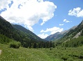
Trepidation notwithstanding, the approach to Capitol Lake is also one of the most stunning hikes I've ever made in Colorado. The majesty of the Elks is on full display in this wilderness with ever-improving views of Capitol all along the way.
Near the head of the Ditch trail
I wonder why this is nicknamed the "Ditch" trail?
All of Capitol and "K2" now coming into view
An interesting thing happens along this trail: Everybody going uphill is pumped-up with nervous energy about the challenge ahead. Everybody coming downhill has the swagger of a Viking returning from battle, especially if they'd successfully summitted. This invariably leads to conversations along the lines of: "Hey ... did you make it? How bad was the knife-edge? How loose is the rock? Would you climb it again? Etc, etc ..." with answers like, "Oh the knife-edge is overrated. I decided to do a handstand across the entire ridge just to make it interesting ..." You get the idea.
On the way up, you're the inquisitor. On the way down, you're the subject of the inquiry. If the guy coming down the trail is way too casual about the risks and dangers he'd just faced, check for dried urine stains. He's probably lying.
Rob with Capitol and Daly Peak behind
Your humble correspondent
We made pretty solid progress all the way to Capitol Creek, filtered some water on the way across, and breathed a sigh of relief when we got to the "Don't-worry-about-having-to-step-on-any-more-cow-mines" gate.
Cap through the trees
Entering the forest - now I understand where so many of the "Middle Earth" references come from.
We made it to Capitol Lake in roughly 3 hours - just in time to find all the designated camping spots already taken. One of the groups was kind enough to let us pitch our tents on a flat spot near their campsite. We got everything set up, went back to the creek to filter some more water for dinner, and managed to catch a coveted view of Capitol in alpenglow:
This alone made the hike to the lake worth it
I'd learned my lesson a few weeks earlier during a miserable climb of Shavano / Tabeguache about getting sufficient rest and more importantly, sufficient fuel before a big day. So I cooked up a "Serves 2" Mountain House meal and quickly downed it. And then I cooked another one. No way was I going to bonk on Capitol due to a calorie-deficiency. Rob looked at me like I was Kobayashi. I get that a lot.
We soon after hit the sack to maximize rest before a 4:00AM wake-up call. And then the wind started ...
I don't think anybody got more than 20 minutes of continuous sleep at Capitol Lake that night. Nerves were already a factor to begin with. Just as you'd start to doze off, a huge gust of wind would whip up and cause the nylon of the tent fly to snap, bringing you wide-awake again. A lot of climbers were having a rough day on the mountain the next day, and I really think that the wind that night was the biggest reason why.
Rob and I woke up, gassed up, and got underway by 4:30AM. We were the first headlamps up the switchbacks to Daly Pass. As soon as we crested Daly Pass we were immediately blasted by 25-30 mph gusts. Oh crap. No way would I be hanging it out over the knife-edge if this was a harbinger of things to come. Nothing more to do than press on and make the final call at K2.
The trail up to and just past Daly Pass is well-maintained and defined. Then, all of a sudden, it just falls apart. We found our headlamps scanning some Class 3 / 4-ish gullies with no obvious path forward. So Rob and I decided to hunker down for a few minutes, allow others to catch up, and see if daybreak would illuminate the correct path forward. It truly is remarkable how the trail goes from perfectly defined to non-existent in the space of about 10 feet. We eventually found a literal 'high road' across the gullies by following the path of least resistance and spotting the sparsely-placed cairns. Once past this obstacle, the climbing is Class 2 all the way to K2, and the cairns become much more plentiful.
Sunrise over Daly Pass - looking back at the 'undefined' portion of the trail. Climbers can be seen working along the talus.
Follow the talus to the base of the snowfield and then turn right.
The route up to K2
On the way up to K2, the Maroon Bells and Snowmass finally come into view as well.
Morning light on the Bells
The twin summits of Snowmass
K2 is another really interesting rock feature. The hike to within 30 vertical feet of the summit never exceeds class 2, and from below, looks like just another insignificant bump in the talus field. However, as you approach the summit, Capitol's legendary exposure immediately rises up, drops its pants, and moons you from both the east and the west. Climbers often tend to underestimate just how dangerous K2 is in and of itself since they're mentally already preparing for the knife-edge ahead. This insignificant sub-peak can and has killed climbers trying to traverse around it.
Rob with K2 and Capitol behind him. See mom? He's wearing his helmet.
As the talus field chokes down to a point near the summit of K2, the two obvious choices are to go straight up to K2's summit with some Class 4 moves, or to take a Class 3 ledge bypass around to the west. Rob and I chose the short Class 4 alternative for the purposes of getting warmed up to the technical moves ahead and to also mentally 'ease in' to the exposure. Fortunately, the wind had now mostly abated. It looked like we were gonna have a great day, after all.
Class 4 scramble to the summit of K2 in red with the Class 3 bypass in yellow
A climber can be seen on the ledge bypassing K2's summit
Looking back along the ledge (on the way home)
That 60 degree slope beneath the climber doesn't relent for another 1,100 feet
Rob gets ready to scramble up to K2's summit
The first full look at the Northeast Ridge from K2's summit
Panorama from the summit of K2
That's where we gotta go? No sweat. 10-15 minutes tops.
The Capitol - Snowmass Ridge. I believe it's been dubbed, "Satan's Ridge". No thanks. Not in this lifetime.
The climb down from the summit of K2 has some straight-forward Class-3 sections to get down about 50 vertical feet or so along the western face. It's worth it to summit K2 for the views alone.
Rob makes his way down K2 with climbers seen near the summit
Note the climbers on the ridge. Here's the reason why you can't climb over K2 ...
... which then degenerates into this couloir.
Climbers approaching the knife-edge
I caught up with with a climber named Tom who was moving a little bit ahead of his group (part of 14ers.com member, Uffda's group that day). Tom, Rob and I became a de facto group of three for the remainder of the climb. I think we all felt the more eyes, the better for route-finding higher up.
Tom taking a moment to contemplate his mortality before heading across the knife-edge
Rob starts making his way across
Rob completing the knife-edge. Piece 'o cake
Plenty of challenges lay ahead along the ridge past the knife-edge. The exposure's just not nearly as insidious.
Rob working his way along the ridge past the knife-edge
Pierre Lakes now come fully into view
Picking around "Secret Chute", the remainder of the climb becomes an ascending traverse towards a high notch along the southeast ridge. We followed cairns and common sense to find a line roughly 50 vertical feet below the ridge crest that got us to the next challenge, a distinct band of purple rock.
Ascending traverse line in yellow. A climber can be seen near the top of "Secret Chute". The line in red is a fun Class 4 / Low 5 alternative above the notch.
The 'purple band' is one of the last hurdles before the summit only because exposure begins to become a factor once again. We actually chatted with a couple near the Capitol Creek crossing that had made it this far, then had turned around after not being able to figure out a way across. The important lesson is that after the knife-edge, you're not necessarily home-free.
Tom approaches the purple band. Note the three routes across in yellow. Tom took the low road, Rob and I the middle, and then the high road on the way down. All routes go - you just have to figure out what you're most comfortable with. Just keep working towards the notch.
Tom making his way across the low traverse
Once at the notch, Rob and I spotted a Class 4 / Low 5th Class alternative to ascend the southeast ridge.
Rob leading the steep alternate pitch
Turn left to intersect the southeast ridge once again. Note the climbers working directly up the ridge crest
Most climbers get into the habit of going directly up the southeast ridge since it seems intuitive, and we've all studied the same route photos that tell us to ... . However, if you go through the notch there are several more accommodating trail segments that provide easier routes to the summit ridge. These trails get more heavily used by climbers coming down once they've realized that this alternative exists.
Options past the notch in the southeast ridge
Once at the summit ridge, turn west to reach the summit. Many will make this traverse a few feet below the ridge crest, where the route is a bit more sheltered. If you have any nerves left that aren't completely frayed at this point, you can traverse along the top of the ridge for some fantastic views down the north face.
Uffda gaining the summit ridge
I chose to take the apex of the summit ridge for one, last, spicy alternative to reach the summit.
Capitol Lake, now a long, looong, way down there
"Success!"
"Big deal, Phil. Can we get outta here now?"
Panorama from the summit of Capitol Peak
The trip back was uneventful other than the fact that we used the alternate "south face" routes rather than try to descend the southeast ridge directly. Also, after having taken a high traverse line across the 'purple band', I had to keep a close eye on two climbers below me and be careful not to knock any rocks down on them. I don't think they were ever aware of my presence above them. All that was needed was one more trip across the knife-edge and a safe traverse around K2 before we could let our guards down.
Back across the knife-edge
Halfway home ...
Yeah, it is that steep
Short knife-edge video
Once safely past K2, I gave my wife the obligatory "I-don't-think-I'm-going-to-die-on-the-mountain-today" phone call. I noticed that if you stay next to the northwestern side of the ridge below K2, you have direct line-of-sight to Carbondale, and pretty good cell coverage.
At Daly Pass, we knew all technical climbing was done for the day and it was then just a matter of packing up and slogging back down the valley to the truck. The hike back also gives you the first daylight glimpses of Capitol Lake's splendor:
Capitol Peak from below Daly Pass
Capitol Lake
Rob and I made it back down with little fanfare and drove back to Glenwood Springs to see if we could clean the town out of all of its groceries. One of my favorite things to do after a grueling day is to roll into a Subway or a Chipotle looking like something that the cat dragged in. An unspoken conversation always takes place with the person behind the counter who looks you up and down and silently asks, "Which bridge do you sleep under last night?" My internal response is always the same: "Buddy, if you only knew ..."
A great read and great photos. Solid work! I have a lot of appreciation for the level of mental preparation that a peak like this imposes on you. Pyramid put that same sort of pre-climb anxiety on me but ended up being a great day. Of course I realize Pyramid is merely a small step towards feeling ready to tackle Capital.
Now that is a well documented adventure. I've been dreaming of spring and summer and your report just shot my dreams into high gear. I plan to enjoy some quality time in the Elks this summer and I think Capitol is up near the top of the list. Excellent photos and route information - thanks!
Even though I let way too much time pass before putting the TR together, it's remarkable how the details of these difficult mountains are forever etched in your memory. I remember every nuance of those 2 days. I'm not sure I can even recall what Mt. Yale even looks like ...
Everything about this mountain is superlative... 1/5/2014 4:31am
... including this TR. Even after two years, this is indispensable beta for my family group as we make plans to attempt Capitol in August. Your efforts are truly appreciated. Your Snowmass S Ridge TR helped us safely enjoy that classic route, and I have a feeling this one will do the same.
Caution: The information contained in this report may not be accurate and should not be the only resource used in preparation for your climb. Failure to have the necessary experience, physical conditioning, supplies or equipment can result in injury or death. 14ers.com and the author(s) of this report provide no warranties, either express or implied, that the information provided is accurate or reliable. By using the information provided, you agree to indemnify and hold harmless 14ers.com and the report author(s) with respect to any claims and demands against them, including any attorney fees and expenses. Please read the 14ers.com Safety and Disclaimer pages for more information.
Please respect private property: 14ers.com supports the rights of private landowners to determine how and by whom their land will be used. In Colorado, it is your responsibility to determine if land is private and to obtain the appropriate permission before entering the property.