Download Agreement, Release, and Acknowledgement of Risk:
You (the person requesting this file download) fully understand mountain climbing ("Activity") involves risks and dangers of serious bodily injury, including permanent disability, paralysis, and death ("Risks") and you fully accept and assume all such risks and all responsibility for losses, costs, and damages you incur as a result of your participation in this Activity.
You acknowledge that information in the file you have chosen to download may not be accurate and may contain errors. You agree to assume all risks when using this information and agree to release and discharge 14ers.com, 14ers Inc. and the author(s) of such information (collectively, the "Released Parties").
You hereby discharge the Released Parties from all damages, actions, claims and liabilities of any nature, specifically including, but not limited to, damages, actions, claims and liabilities arising from or related to the negligence of the Released Parties. You further agree to indemnify, hold harmless and defend 14ers.com, 14ers Inc. and each of the other Released Parties from and against any loss, damage, liability and expense, including costs and attorney fees, incurred by 14ers.com, 14ers Inc. or any of the other Released Parties as a result of you using information provided on the 14ers.com or 14ers Inc. websites.
You have read this agreement, fully understand its terms and intend it to be a complete and unconditional release of all liability to the greatest extent allowed by law and agree that if any portion of this agreement is held to be invalid the balance, notwithstanding, shall continue in full force and effect.
By clicking "OK" you agree to these terms. If you DO NOT agree, click "Cancel"...
We were at the trail head by 5:30 and happy to find a compacted trail. My snowshoes were unnecessary for the first two miles of the trip and we were making terrific time. This would soon change.
Ryan and Eric skinning below tree line
Unfortunately, whoever had made the newly compacted trail did not take the sharp turn to the south east, and we too overshot the route. By the time we realized it, it was too late to turn back. Our correction would lead us off the beaten path and into some hellish powder of the likes I don't want to experience again.
Eric finds powder
My snowshoes (with the tails) were no match for the powder that we experienced, and for a short while, I was envious of Eric and Ryan's skis.
When we finally hit tree-line it was clear we needed to make a long traverse to the south to get back on route. Weather had been fantastic up to this point but this too would change quickly at about 12,500 ft.
Eric and Ryan vs Winds and Vert
The wind picked up almost as quickly as we bad mouthed the weather man and his failed predictions. Eric and Ryan also began having issues with the skis about the time the wind picked up. The skins seemed to be no match for the line we had chosen to follow, yet going without skis wasn't an option because of post-holing. They both made it work, and we began our final push to the ridge at about 10:30. We made a very optimistic estimation that it would take a half an hour to get to the ridge, but things slowed down quickly and that half an hour turned into an hour and a half.
James' anemometer
Eric and Ryan chose to follow the traditional route and start the ridge on the north side end, but because I was already south of that position, I chose to cut up the middle instead of going around. I began my bouldering as Eric and Ryan disappeared behind north side of the ridge. The winds seemed to aide in my climb as it pushed on my snowboard from behind. When I checked wind speed at this spot, I was getting readings from 70-80 km/h, and gusts as high as 93km/h. When I made it to the top of the ridge I no longer felt safe with my board on my back and left it behind to prevent being blown off the northeast face of the mountain.
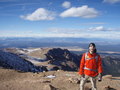
Princeton from Summit
Elks in the distance
James makes summit
As I approached the summit I could see Ryan making his way up the ridge, then soon after was Eric.
Ryan makes summit with skis
Eric makes summit with skis
When we met up at the summit, Eric quickly regretted leaving his skis behind. Ryan and I watched as he returned down the ridge to fetch his skis in order to have a true ski descent from the summit.
The winds were brutal at the summit, and after some pictures, I too returned down the ridge, grabbed my snowboard and continued back down to the bowl as Ryan and Eric made their descent from the northeast face.
Not good for ski descent
My snowboard descent down the bowl was good until I hit the packed snow near the bottom. I waited here for Ryan and Eric to make their way from the summit.
Walking was required for some time before we could get back on our board and skis. As we traversed back to our original route, I broke from the line and again split up from Ryan and Eric as I cut straight west towards the compacted trail. My fear was that I would get stuck in the same powder that we had trouble getting through on our way up.
Even as I cut a line straight down the mountain and tried to keep the tip up, my board still wasn't able to handle the deep powder in the trees. To make matters worse, I got stuck on the side of a stream and needed to put my snowshoes back on to get across. By this time, I was so frustrated with the powder that I chose to snowshoe down the rest of the mountain. Of course, this choice received much criticism and laughter from the skiers. Thanks guys!
We made it back to the trail head around 4:00. The trip took much longer than we had expected and we had worked much harder than we had anticipated, yet it was still rewarding to complete such a feat.
Thumbnails for uploaded photos (click to open slideshow):
We crashed at Avalanche Gulch the same night you all were there. I thought the snow looked like crap from the road, and as the wind speed continued to increase, we made the not too difficult decision to sleep in and get coffee at Bongo Billy's in BV. Will be back next weekend to see if this recent storm holds better. Kudos for summiting in that not fun wind.
Sorry I didn't see this right away. I'm not sure of the elevation but it was about 500 vertical ft short of the tree line. You'll know you're there when you get to the field surrounded by trees. This is where the turn off should be around. If you cut straight right through the field, you've gone too far.
I definitely won't ever leave my pack to make a summit push again, no matter how strong the winds are.
Still happy I re-summit-ed and got the ski
Good day for sure
Caution: The information contained in this report may not be accurate and should not be the only resource used in preparation for your climb. Failure to have the necessary experience, physical conditioning, supplies or equipment can result in injury or death. 14ers.com and the author(s) of this report provide no warranties, either express or implied, that the information provided is accurate or reliable. By using the information provided, you agree to indemnify and hold harmless 14ers.com and the report author(s) with respect to any claims and demands against them, including any attorney fees and expenses. Please read the 14ers.com Safety and Disclaimer pages for more information.
Please respect private property: 14ers.com supports the rights of private landowners to determine how and by whom their land will be used. In Colorado, it is your responsibility to determine if land is private and to obtain the appropriate permission before entering the property.


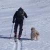
 James and Eric near the trailhead")
 Ryan and Eric skinning below tree line")
 Eric finds powder")
 Eric and Ryan vs Winds and Vert")
 James' anemometer")
 Princeton from Summit")
 Elks in the distance")
 James makes summit")
 Ryan makes summit with skis")
 Eric makes summit with skis")
 Not good for ski descent")
")
")
")