Download Agreement, Release, and Acknowledgement of Risk:
You (the person requesting this file download) fully understand mountain climbing ("Activity") involves risks and dangers of serious bodily injury, including permanent disability, paralysis, and death ("Risks") and you fully accept and assume all such risks and all responsibility for losses, costs, and damages you incur as a result of your participation in this Activity.
You acknowledge that information in the file you have chosen to download may not be accurate and may contain errors. You agree to assume all risks when using this information and agree to release and discharge 14ers.com, 14ers Inc. and the author(s) of such information (collectively, the "Released Parties").
You hereby discharge the Released Parties from all damages, actions, claims and liabilities of any nature, specifically including, but not limited to, damages, actions, claims and liabilities arising from or related to the negligence of the Released Parties. You further agree to indemnify, hold harmless and defend 14ers.com, 14ers Inc. and each of the other Released Parties from and against any loss, damage, liability and expense, including costs and attorney fees, incurred by 14ers.com, 14ers Inc. or any of the other Released Parties as a result of you using information provided on the 14ers.com or 14ers Inc. websites.
You have read this agreement, fully understand its terms and intend it to be a complete and unconditional release of all liability to the greatest extent allowed by law and agree that if any portion of this agreement is held to be invalid the balance, notwithstanding, shall continue in full force and effect.
By clicking "OK" you agree to these terms. If you DO NOT agree, click "Cancel"...
Mt. Consitution: Highpoint of the San Juan Islands archipelago and highpoint of San Juan County, WA
Loop distance: 6.7 miles
Total elevation gain: 1,500 feet (plus some up-down gain on the descent)
Round-trip time: 3 hours, including time on top
Reference: "Day Hiking North Cascades," by Craig Romano
Even though I'm partial to climbing high peaks, I still enjoy climbing lower ones, especially those with healthy prominence or highpoint status.
Mount Constitution on Orcas Island is one such mountain. Even though it's only 2,409 feet tall, it rises abruptly from the sea at its base, and its summit affords incredible views of northwest Washington and British Columbia.
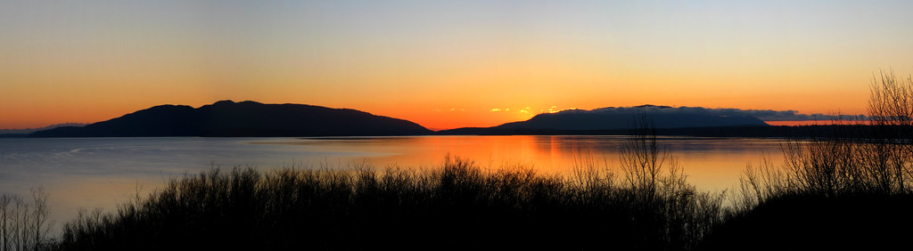
From my home in Bellingham, Washington, I can see Mount Constitution on Orcas Island. It's a long and serene-looking island that just beckons a visit. Needless to say, it didn't take me and Jen long to succumb to its charms.
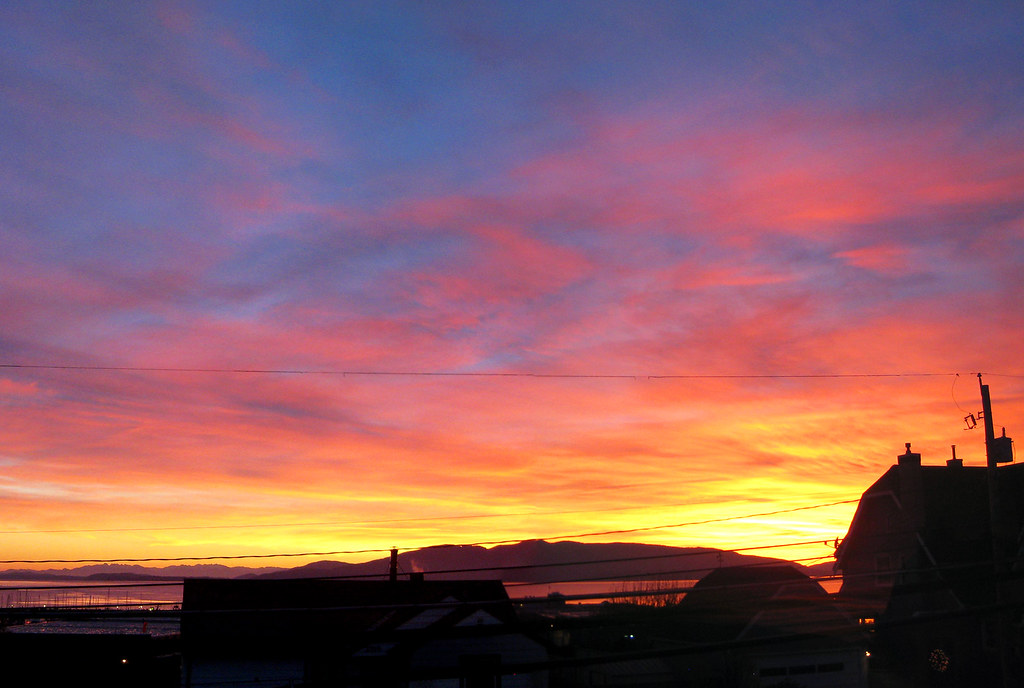
Olympic Mountains lower-left, Lummi Island center, sliver of Orcas Island to the right:
Lummi Island on the left; Orcas Island on the right:
Among the more than 700 islands (172 of which are named) in the San Juan Islands archipelago of northwestern Washington, Orcas Island is the largest (about 57 square miles) and the tallest (2,409'), though it's not the most populated (its population is less than 5,000). The idyllic island, which is covered with mountains, forests, waterfalls, streams, pastoral valleys, rocky outcrops and freshwater lakes, wraps around a large fjord.
Contrary to what I thought, the name of the island does not come from the many Orca whales that frequent the area, but it's actually a shortened version of Horcasitas, who was some guy from Mexico who sent an exploratory expedition to the Pacific Northwest in 1791. This explains why the island's name is pronounced "OR-kiss" and not "OR-cus."
After a one-hour drive to Anacortes and then a relaxing, one-hour-and-twenty-minute ferry ride to Orcas Island, we developed quite the appetites. We planned to eat on the ferry, but we learned that it doesn't offer food service on board during the off season.
Washington State Ferry, Hyak:
The boat made a quick stop at Shaw Island before crossing the channel to Orcas Island:
After driving off the ferry and into the quaint town of Orcas Village, which is comprised of only a handful of buildings, we immediately parked and walked up the hill in search of food. Unfortunately, nothing was open.
Orcas Village:
While peering hungrily into one closed restaurant, we were startled by a woman who sounded like my grandma. Even though her restaurant was closed, she said, "I can cook you something if you can wait 10 minutes." Her unexpected kindness was a little strange, but we graciously accepted her offer, and 15 minutes later we were devouring some delicious halibut fish and chips.
With only a few hours of daylight left, we decided to do the little hike to Obstruction Pass, on the southeast end of the island. Even though it rained lightly, it was a beautiful hike, and we had the entire trail and the 400-yard pebble beach all to ourselves.
I swear I'm really not a "treehugger":
Seaweed and other signs of sea life on the beach:
That evening we stayed at a condo in Eastsound, which is the largest town on the island. "Largest town" is a relative term, though. It's really just a little community of artisans and small-business owners.
Eastsound, WA:
In 2009, Eastsound was named one of the "100 Best Adventure Towns" by National Geographic Adventure magazine. Being that we're in the middle of the off season, the town was quiet while we were there, but I can only imagine how busy it gets in the summer, with all the kayakers, bikers, hikers and whalewatchers swarming the island.
The following morning, after wolfing down a large breakfast, we headed to the Mountain Lake trailhead in Moran State Park.
Moran State Park, on the eastern arm of Orcas Island, is the fourth-largest state park in Washington. It has 5,000 acres of forest and lakes and it has roughly 35 miles of trails.
There is a road to the summit of Mount Constitution, but you wouldn't know it when you're on the trail, as it rarely gets close to the road. In fact, the trail was surprisingly quiet. All I could hear was the wind in the trees and the cascading water in the woods.
At first, the well-maintained trail leisurely contours Mountain Lake, which harbors a small, lonely island.
It was a cloudy day with periodic episodes of light rain, but the temps were good for hiking. Perhaps it was even a little too warm for my liking, as I tend to sweat profusely in the humid, Pacific Northwest air, even when the temperature dips into the 30s.
Speaking of the weather, the San Juan Islands enjoy a temperate climate. In January, the average low is only 36 degrees and the average high is 46 degrees.
The cloudy sky and the thick canopy of trees above us made the forest really dark. Wild contrasts of light tricked my eyes throughout the day. Babbling streams were like bright ribbons of white, and once my eyes got accustomed to the darkness, it almost hurt my eyes to look at them. The electric green moss also had a curious luminescence to it. Jen pointed out that my jacket was perfectly camouflaged.
Beyond the lake, we started up some steep switchbacks. The extra exertion made me immediately start sweating. It's amazing how quickly you can go from cold to hot in the PNW - just add exercise.
I could hear a light rain tapping on my hood, but the canopy of trees above us blocked most of the moisture.
As expected, when we finally gained the summit, there wasn't a view from the top because it was completely socked in.
Though we could read what we should have seen:
The CCC-built stone tower on the summit of Mt. Constitution:
On the descent, I was surprised how steeply the mountain dropped off, just feet from the trail. The fog didn't allow us to see the bottom, but I could tell it was a long way down. I recalled reading about some deaths from falls, but wondered where they occurred. While staying safely on the trail is fairly easy, I could see how one wrong slip on a slick, mossy rock could prove fatal.
After a wet slog with lots of ups and downs on the ridge, we made it back to the trailhead in just over an hour. Overall, it was a great hike, and it was one we had all to ourselves (excluding the trail crew we came across doing some trail maintenance).
Post-hike, we toured around the island a bit, which didn't take very long, as there was no traffic and there are no stoplights on the island.
Deer Harbor received a little sun:
The following morning we got up early so that we could drive to the top of Mount Constitution, in the hopes of seeing the view we missed on our hike. The mountain gods treated us well, as it was a clear day. Albeit a cold and windy one.
The road to the top was littered with debris from the high winds. We even stopped to move some of the larger branches off the road.
The temperature on the summit was a bone-chilling 24 degrees, and fierce winds put the wind chill much lower.
Jen on the iced-over summit, looking east-southeast toward Mt. Baker and the Twin Sisters (North Cascades):
Zoomed-in shot of Mt. Baker and the Twin Sisters (Bellingham is lower-left, but not really visible through the haze):
The view from the top of Mount Constitution was amazing, and it was much better than I expected. And I expected a lot.
"We earned this view," Jen said.
Looking south, with the Olympic Mountains barely visible in the distance:
Looking north-northeast toward the mountains of lower British Columbia (the city of Vancouver was just out of frame, to the left):
The following morning we did a much easier hike of Ship's Peak on Turtle Mountain:
It didn't show up well in photographs, but we could easily see Sidney and Victoria on British Columbia's Vancouver Island:
While on the ferry going back to Anacortes, we enjoyed some more great views of Mount Baker:
After this hike, I decided that mountain climbing does not always have to be about the challenge. Sometimes it's fun to just hike a mountain for the sake of getting to know the mountain.
Thumbnails for uploaded photos (click to open slideshow):
Aubrey, since I have to live vicariously through you guys in the PNW, here is one you should try with Jen that my wife really wants to try someday: http://www.besthike.com/northamerica/canada_west_coast/della.html
I'm sold, Aubrey. You are 3/3 in the awe-inspiring department with your PNW reports. Nice work and thanks for showing the surrounding regions, getting a full perspective. A 360 pano in Washington looks a whole lot better than one around here, thats irrefutable. Looks like Endor : Land of the Ewoks around there.
I absolutely love image 12! I have a picture similar to that when I biked through Del Norte Redwoods State Park in northern CA. Though I've never visited Washington, your pictures and reports make me want to go there so much more now. Thanks for posting!
That temperate climate of the PNW sounds rather appealing right now. As much as I've been spoiled by the abundant sunshine of CO, I still find rain and fog very peaceful. I spent some time on the Olympic Peninsula one winter and always remember the way the fog would hang in the pines like that. Thanks for giving us another little taste of something different.
PS: That shot of you camouflaged against the moss is priceless.
May not be a 14er but that's real mountaineering compared to what we have got! Thanks for showing something outside our bubble here in Colorado where mountaineers tend to go down in elevation rather than up as we move from 14ers to centennials to 13ers to 12ers etc.
San Juan Islands Highpoint (the other San Juans) 2/15/2011 11:41pm
Nice shots, Aubrey. I lived in NW Oregon, Washington, Juneau and northern BC for the last 17 years up till a year ago, when we moved back to CO. Orcas and the rest of the San Juans are great places to hike, as is the outer Peninsula around Cape Flattery down south to at least Kalaloch, as Anna pointed out. Great coastal hikes. But go a little further north and hike on Vancouver Island or in SE Alaska; some of the coastal hikes are amazing. Very similar forests and climate to the San Juans, but without the crowds. Plus you get 15ers-18ers, like Mt. St. Elias and Mt. Fairweather, up near Glacier Bay. If you like the remoteness, you may never come back south. Good report; makes me miss the NW all the more. I'm moving back north in two years and this time I'll stay north. Joe
Really beautiful! I'm up in the Inland Northwest myself right now i.e. Northern Idaho :-)
Caution: The information contained in this report may not be accurate and should not be the only resource used in preparation for your climb. Failure to have the necessary experience, physical conditioning, supplies or equipment can result in injury or death. 14ers.com and the author(s) of this report provide no warranties, either express or implied, that the information provided is accurate or reliable. By using the information provided, you agree to indemnify and hold harmless 14ers.com and the report author(s) with respect to any claims and demands against them, including any attorney fees and expenses. Please read the 14ers.com Safety and Disclaimer pages for more information.
Please respect private property: 14ers.com supports the rights of private landowners to determine how and by whom their land will be used. In Colorado, it is your responsibility to determine if land is private and to obtain the appropriate permission before entering the property.


")
")
")
")
")
")
")
")
")
")
")
")
")
")
")
")
")
")
")
")
")
")
")
")
")
")
")
")
")
")