Download Agreement, Release, and Acknowledgement of Risk:
You (the person requesting this file download) fully understand mountain climbing ("Activity") involves risks and dangers of serious bodily injury, including permanent disability, paralysis, and death ("Risks") and you fully accept and assume all such risks and all responsibility for losses, costs, and damages you incur as a result of your participation in this Activity.
You acknowledge that information in the file you have chosen to download may not be accurate and may contain errors. You agree to assume all risks when using this information and agree to release and discharge 14ers.com, 14ers Inc. and the author(s) of such information (collectively, the "Released Parties").
You hereby discharge the Released Parties from all damages, actions, claims and liabilities of any nature, specifically including, but not limited to, damages, actions, claims and liabilities arising from or related to the negligence of the Released Parties. You further agree to indemnify, hold harmless and defend 14ers.com, 14ers Inc. and each of the other Released Parties from and against any loss, damage, liability and expense, including costs and attorney fees, incurred by 14ers.com, 14ers Inc. or any of the other Released Parties as a result of you using information provided on the 14ers.com or 14ers Inc. websites.
You have read this agreement, fully understand its terms and intend it to be a complete and unconditional release of all liability to the greatest extent allowed by law and agree that if any portion of this agreement is held to be invalid the balance, notwithstanding, shall continue in full force and effect.
By clicking "OK" you agree to these terms. If you DO NOT agree, click "Cancel"...
Climbers: Zambo, Benners, & Lord Helmut Conditions: The definition of a Bluebird day. Not a cloud in sight, absolutely NO wind, climbing in a t-shirt without hat or gloves all the way to 14,000ft. Avy Conditions: Stable conditions on Northwest to West facing aspects consistent with the CAIC report. A few potentially unstable fields right at tree line. Solid snow above tree line with minimal trenching, and a stable pack along the Northwest gully complete with excellent skiing! Windblown along the ridge for a mix of solid snow & talus. Road Conditions: Snowmobile track and packed snow all the way to the Missouri Gulch TH. A 4wd with high clearance and a skilled driver could maybe make it up. More snow will certainly change this, but it might be worth a shot. Some of the biggest drifts were along the first mile of road. Summary: A long but rewarding day. Plans to get both Belford and Oxford didn't pan out, but after 17 miles, 5,500 vert we were quite satisfied with a Belford summit. An absolutely gorgeous day out with great friends and partners.
Report*:
In some ways, Belford is a cruel mountain. It denies you a view of the summit until you are within the final 50 yards. The rest of time you find yourself staring up in frustration wondering, "how much longer will this go on?" However, like most of the high places in Colorado, the reward is well worth the effort.
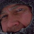
These were some of my reflections as I crested the final shoulder and saw Benners standing on the summit block. It had been a long and grueling, but absolutely spectacular climb to the top...
Success!
The whole idea for this trip originated out of some remaining bitterness from the previous weekend's outing. After turning back 8 hours and 350 feet from Ellingwood's summit (that is an entirely different story) we were determined to get a peak this weekend. With favorable avy conditions and a perfect forecast looming, Benners, Lord Helmut, and I ventured out to take our shot at a Belfox winter ascent.
We left the car at the Clear Creek Ranch - the end of the plowed winter road. Unsure of road conditions ahead, we decided to not risk getting stuck and earn our badges by adding an extra 8 miles along the road (this would come back to haunt us on the descent). We found the road in fair conditions. Snowmobile track and packed snow all the way to the Missouri Gulch TH. In my opinion, a 4wd with high clearance and a skilled driver could have made it up. More snow could certainly change this, but it might be worth a shot. Some of the biggest drifts were along the first mile of road.
The 4 miles of road only gains 450 ft, and we found ourselves at the summer TH after 2 hours of easy trekking.
The road isn't so miserable the first time around... Taking a pee-break Dumb and Dumber style Not quite as many gapers at Rockdale on January 29th.
After dropping water and layers (it was already warm) at the summer TH, we headed up Missouri Gulch. To our absolute delight, we found broken trail through the trees. Although not on the register, someone had been up there in the past few days (anyone know who??). Regardless, thank you for the trench - it was very much appreciated!
The uneventful climb through the trees turned to excitement just below tree line. Consistent with the CAIC forecast, we found one suspect avy slope right before the trees broke. Fully implementing a "sure, go ahead and take the lead, Brian" attitude (hehe), we heard a few "woomps" low on the slope. The consensus was this was due to the snow settling over the willow field, but still hair-raising nonetheless.
Up to this point we had been hauling through the trees, but this slope slowed us down quite a bit as we picked our way around it.
Signing in at the register. A thousand thank yous for the group that had broken trail for us!
Breaking the trees, we got our first good look at Belford. The snow turned very solid at this point, and we made our way to the base of the Northwest Gully. Unsure of which route would be better, we dug our pit to check avy conditions. The snow pack was very favorable and Ben and Brian decided to head up the gully - the preferable option for skinning. Being on snowshoes - and enjoying ridges more anyways - I opted to take the ridge and meet them higher up.
First real look at Belford Up closer. The avy slope coming off the ridge is dry as you can see. Looking back down from the spot of our pit. Views of the gulley route ahead.
At this point of the climb, the difficulty and exhaustion lever ratcheted way up. Finally hitting some serious vertical was matched by baking in the sun. I was down to a t-shirt, no hat, and no gloves for the entire length of the ridge. However, the weather was nothing to complain about as it was an absolutely perfect day. Never a cloud in sight and NO wind whatsoever. The snow along the ridge was wind blown and solid with plenty of rocks to pick your way through. The guys below found solid snow perfect for skinning all the way up to approx 13,000ft.
Climbing alone in the calm and looking at the majesty around me, I couldn't help but be in wonder of our beautiful mountains. The white coat and loneliness of winter only further highlights the scene.
Brian working it. Topping out of the gulley somewhere around 13,000ft. A good beta shot of the end of the gully snowfield. Splitting up made for some wonderful shots back and forth. There I am working the ridge. Another one from along the ridge. Looking down at the guys skinning along.
The skiable snow ended approx 1,000 feet from the top as Ben and Brian regained the ridge to join up with me for the final summit push. It had been a long day to this point, and it was only going to get harder from here. We dropped skis and snowshoes and worked our way upwards. It was slow going as Brian and I were particularly winded. To make matters worse, we just never knew where that damn summit was, which is maddening that far into a day.
High upon Belford, Ben's view looking back. He must be wondering, "What is taking those guys so long?" A much needed breather. Final push to the summit.
However, like all summits, it must eventually come and I caught first glimpse of the top at 4:00 - after 9 hours, 8.5 miles, and 5,200 vertical feet of slogging. Unsurprisingly, the views from the top were absolutely stunning. On this beautiful day we had views dozens of peaks and ranges in view for miles and miles in every direction.
Success! Views over to Oxford. From here, it certainly looks like conditions are good to go get it if anyone has a mind. Thinking of the 14ers crew over on La Plata.
The original hope had been to get Oxford as well, but as with all winter ascents, things just never come as easily or as quick as you might hope. Sitting on the summit at 4:00, we discussed going and getting it for a while. From a physical standpoint we were confident we'd be ok, but that would mean an entire descent (including the skiing) of Belford in the dark. Not even to mention the time we would get back home.
In the end, we decided to leave Oxford for another day. Brian wisely reminded us that any winter peak is a worthy accomplishment, and going for more at that point in the day opened the door to all kinds of potential issues. The mountain isn't going anywhere, and we decided to relax on the summit enjoying the views, leaving Oxford alone for now.
What had taken over an hour on the ascent was a quick 20 minute hike back down to the skis and the top of the snowfield at approx 13,000-13,500. Opting to avoid snowshoeing down the steep upper slopes of the gully, I hustled down the ridge for a rendezvous at Belford's base while Ben and Brian put on their sticks to ski the gully.
Is there a better view than sunsent from a winter 14er? I'm always amazed at how much faster the descent is. Can you see me? Some beautiful lighting at sunset.
Upon reaching the guys, they were beaming with what had been excellent conditions for a very fun ski descent. I'm sure they can provide better details, but they were thoroughly satisfied with the effort as we packed up and headed back to the trees. The gully is definitely in!
First turns Top of the steepest secion of the gully. Further along
Moving back into the trees, I enjoyed watching these guys pick their way through the narrow/rocky trees on the descent in the dark - one of the few places where snowshoes makes things easier. We reached the summer TH soon enough, and one of my favorites moments from the climb came next.
Standing there in the parking lot we took a moment to kill headlamps and simply look up. Despite the long hours, cold, exhaustion, and more work to come, standing there in the peaceful silence and looking up at the stars gets me every time. So quiet, so alone, so peaceful...I overwhelmed with just how blessed I am to live here and get to do this. It was a beautiful night.
Then we had to hike the road again.......
What was a mild blip on the radar for the hike in turned out to be 4 miles of pissed-off trudging on the way out. The road has an ever-so mild downwards slope, and plenty of intermittent hills which all but negated the effect of skis. After what seemed like endless, on-and-on-and-on-and-on hiking, the lights of the ranch finally came into view. We all plopped down for a much needed rest and had a lively debate about what exactly is the worst 14er road in the state. We all swore to never hike this one again. I can only hope we are smart enough to keep it keep it...
All in all a terrific day - 17 miles, 5,500vert, and 14 1/4 hours. It's not often that the conditions and forecast coincide so perfectly in winter, and we were very satisfied with the results. Can't wait to get back out there again soon.
Thanks for reading. If anyone is interested in seeing some more beta photos, let me know as I have plenty.
Happy climbing!
*Note: Giving credit where credit is due, the pics are a mix from all 3 of us. But I will say, almost all of the sweetest ones were not from me, lol. Credit Brian, Ben, and Mother Nature for the best shots...
Thumbnails for uploaded photos (click to open slideshow):
I don't know. As I found out last year, hiking the Lake Como road in ski boots from around 8500 to Ellingwood is also pretty miserable. Excellent report, thanks for the beta. Way to get at it!
Brian and I left the gully early and gained the ridge so we never saw what coverage was like around the corner in the upper-gully. I've skied Belford from the top before and Brian just doesn't care that much about skiing from summits so we decided to drop em at 13,500' and save our bases the damage. I'd say given what we saw there's actually a good chance something could be pieced together from the top by wrapping around the west side of the summit block and heading down the NW gully from the summit plateau, in case anyone's interested.
Nice TR my friend. I, too, enjoyed the stars, they were out in full force. Another long, enjoyable day in the Rockies with good company. Thanks for writing this one up and for driving.
Good job gettin some turns in, none the less on a 14er! Good pics too.
Caution: The information contained in this report may not be accurate and should not be the only resource used in preparation for your climb. Failure to have the necessary experience, physical conditioning, supplies or equipment can result in injury or death. 14ers.com and the author(s) of this report provide no warranties, either express or implied, that the information provided is accurate or reliable. By using the information provided, you agree to indemnify and hold harmless 14ers.com and the report author(s) with respect to any claims and demands against them, including any attorney fees and expenses. Please read the 14ers.com Safety and Disclaimer pages for more information.
Please respect private property: 14ers.com supports the rights of private landowners to determine how and by whom their land will be used. In Colorado, it is your responsibility to determine if land is private and to obtain the appropriate permission before entering the property.


 The road isn't so miserable the first time around...")
 Taking a pee-break Dumb and Dumber style")
 Not quite as many gapers at Rockdale on January 29th.")
 Signing in at the register.")
 A thousand thank yous for the group that had broken trail for us!")
 First real look at Belford")
 Up closer. The avy slope coming off the ridge is dry as you can see.")
 Looking back down from the spot of our pit.")
 Views of the gulley route ahead.")
 Brian working it.")
 Splitting up made for some wonderful shots back and forth. There I am working the ridge.")
 Another one from along the ridge.")
 Looking down at the guys skinning along.")
 Topping out of the gulley somewhere around 13,000ft.")
 High upon Belford, Ben's view looking back. He must be wondering, \"What is taking those guys so long?\"")
 A much needed breather.")
 Final push to the summit.")
 Views over to Oxford. From here, it certainly looks like conditions are good to go get it if anyone has a mind.")
 Success!")
 Thinking of the 14ers crew over on La Plata.")
 Is there a better view than sunsent from a winter 14er?")
 I'm always amazed at how much faster the descent is.")
 Some beautiful lighting at sunset.")
 First turns")
 Further along")
 Top of the steepest secion of the gully.")
 A good beta shot of the end of the gully snowfield.")
 Can you see me?")
")