Download Agreement, Release, and Acknowledgement of Risk:
You (the person requesting this file download) fully understand mountain climbing ("Activity") involves risks and dangers of serious bodily injury, including permanent disability, paralysis, and death ("Risks") and you fully accept and assume all such risks and all responsibility for losses, costs, and damages you incur as a result of your participation in this Activity.
You acknowledge that information in the file you have chosen to download may not be accurate and may contain errors. You agree to assume all risks when using this information and agree to release and discharge 14ers.com, 14ers Inc. and the author(s) of such information (collectively, the "Released Parties").
You hereby discharge the Released Parties from all damages, actions, claims and liabilities of any nature, specifically including, but not limited to, damages, actions, claims and liabilities arising from or related to the negligence of the Released Parties. You further agree to indemnify, hold harmless and defend 14ers.com, 14ers Inc. and each of the other Released Parties from and against any loss, damage, liability and expense, including costs and attorney fees, incurred by 14ers.com, 14ers Inc. or any of the other Released Parties as a result of you using information provided on the 14ers.com or 14ers Inc. websites.
You have read this agreement, fully understand its terms and intend it to be a complete and unconditional release of all liability to the greatest extent allowed by law and agree that if any portion of this agreement is held to be invalid the balance, notwithstanding, shall continue in full force and effect.
By clicking "OK" you agree to these terms. If you DO NOT agree, click "Cancel"...
Torreys Peak
Ascent Route: Kelso Ridge
Descent: standard Torreys
Mileage: 7.1
Elevation Gain: 3,100'
No guts, no glory: Darrin (kansas), Kelly (moon stalker), Nick, and me
Elsewhere in the area: KeithK -std route, Scott (edlins) - Kelso Mtn
With the weather forecast and fresh snow, it was unknown what we were climbing, and by what route. It was a drive to the trailhead, start hiking and figure it out, kind of day. Nor did I have much intention of writing this TR, until much later and just below the summit. So this will mainly be a conditions report, as it was too cold and windy to take the camera out too much.
The road and trailhead were free of snow, but the wind and temps told us what kind of day it would be: a cold & miserable @*#$%. Hiking up the trail, the snow went from barely there, to present in a dusting, with areas of ice. The first views of Grays and Torreys confirmed that higher up would be even more snow to contend with.
A glimpse of Grays
Photo credit: Keith
We hit the turn-off to Kelso ridge, and headed up. On the saddle, the wind hit us full force, and we all added another layer, and geared up for the assault. We didn't get up too far, before a group of two guys came down. They were not confident that they could down climb any of the snowy class 3 sections, so they turned around before it got too bad. We followed their footsteps, until there were no more. Another climber caught up to us, Nick from Kansas, and he asked to join our group. Whereas, Keith deciding he didn't like the looks of the snowy ridge or wind, decided the standard route would be his day. We would hope to meet him on the summit.
Kelso Ridge It starts with a nice trail... Chosing the ridge top proper Photo credit: Darrin L to R: Woods, Parnassus, Bard
Once we had our final group settled, we soon found out how exciting this route would be with the ice and snow. In places the route was simple, as the trail was obvious, other places we got a bit off route on our way. But as I hear, being off-route builds character. It also allows for a variety of route choices. Kelly chose a solid class 4 scramble, while Darrin found the class 2 switchback right next to her. Gold star to Darrin. Later the reverse was the case, as Kelly found the better way. So we had some choices lower down, where snow hadn't accumulated too much.
Hello Goats! We ended up following the goats for a while on the ridge A baby goat, this late in the season?
Roughly half-way up the ridge, the snow was much thicker and it began to limit our choices of route. We tried skirting the ridge top, but found snowy loose gullies to traverse a bit too sketchy. We used our axes, as the snow held just enough. I also used the pick for some mixed climbing uses as well. So we went back to the more exposed ridge top, where at least the rocks were blockier and less snow covered. We were above the class 4 crux, before Kelly (who has done the route twice in summer conditions) could point it out. Not too bad considering the snow covering all the familiar moves.
Oh look, here's the trail. Do I get a gold star? Are we there yet? A look back down the ridge, to Kelso Mtn Gurlz in the snow - Photo Credit: Darrin Up the crux
Now our only obstacle remaining was the knife edge. Kelly mentioned having twice "walked the edge", but on this day, that would be a no-go. The knife edge was snow and ice covered and the only safe method was the ol butt scoot - squeeze play. With Darrin going first, he finally learned to brush off the snow off the rocks to be able to find the hand and foot holds. This would be key on the knife edge and around the white tower.
Approaching the knife edge
By the time I had gotten to the knife edge, most of the snow was gone, and I could reasonably cross it. Was even able to stand in a few places, which was helpful - as this knife edge is not flat like Capitol's, but rises in elevation. The last move is difficult, if you don't find foot holds to stand, as Kelly found out the hard way.
Kelly getting personal with the knife edge.
With the limited space around the knife edge, and going around the white tower, we had to help only those in front or behind us. The traverse off the knife edge and around the white tower involved some tricky spiderman moves. Grab hand hold, twist and lower to foot holds below, jump or carefully weight transfer over a gap. While sliding down off the knife edge, my radio fell off. I thought I had lost it for good. But thankfully, by the time I got lower down, there it was on a nice snow pillow. Phew!
Nick tackling the edge Going around the white tower
Once above the white towers, we only had the final pitch up to the summit. Not easy with the thicker snow, but much easier than anything we had just been through. Not sure why or how, but the conditions never really bothered me today. The ice and snow sure made the scrambling difficult, but I was never too concerned. More aware of how careful I needed to be, in the exposed sections. I also had chosen the perfect layering scheme for the weather, which had me perfectly comfortable temperature-wise. This easily may have contributed to my level of comfort on the route.
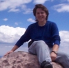
Meet Nick, the new mountaineer from Kansas.
We got to the summit 5.5 hours after we started. No speed record today... After a quick summit photo, and congratulating Nick on a great accomplishment (he only has ~12 14er summits, and nothing in the snow). We all wanted down and out of the wind. At least now, we had a nice trail to follow, all the tough sections were out of the way. Keith didn't like the wind, and due to the difficulty of communicating via radio about where we were on the ridge (which we were not sure how far we were), he turned around at the saddle.
4 tired summiters!
The clouds and falling snow billowed around us, and while Grays Peak looked so close, no one wanted to entertain my partial desire to tackle that summit today. Beer and food would await us in Idaho Springs, and seemed a more worthwhile pursuit. The trail back to the Gray's trail was good, as the snow was soft and mostly untrampled. That would change at the trail junction. Now all the snow is fairly compacted and kinda slippery. This was the only place that micro spikes would have been useful.
Such a nice trail, doesn't Grays look close? A quick pano, before the clouds took back Torreys' summit Hey, where did the peak go? Fluffy snow, made for a nice descent We occasionally saw the evidence of sun
Once we made it down, we headed off to beer and food (our only food of the day - as we didn't break at all on the route), and hear whether Scott found his friend's ice ax that was lost on Kelso Mtn from last year (Still lost). It was a successful, challenging and good day in the mountains.
Thumbnails for uploaded photos (click to open slideshow):
I'm impressed. That knife edge gave me some pause even when it was completely dry. (I might have joined Keith on the standard route.) I love snow hikes but haven't tried anything like that with snow! Great pictures to show just how spicy that route was that day. Good shots of the goats too.
sounding trip! I have always wondered what this would look like in winter conditions, and your photos were the perfect addition to previous reports, and help flesh it out. Glad you guys had a safe, albeit cold sounding trip!
Gold star to you, Otina! You guys have sure done some fun stuff this year. You'll have to hit more winter summits since you're comfortable on that stuff! So Darrin, how many trips and how much gas $ have you spent driving to and from CO this year? Seems like you're out here every weekend!
Or hungry. Or thirsty. Something like that... I was going to summit Torreys at all costs, until I realized that I didn't NEED to!!!
Great report, and congratulations once again on executing that route. Brrr.
Still can't get enough of Darrin's... sense of humor.
That looks like a good trip, I tried to summit Torreys in a blizzard last feb and was unsuccessful having to turn around at 13,700 ft due to avalanche danger (we also had to route find due to the storm - near white out several times and we never saw our summit). We are planning another attempt this coming Feb so I'd like here some greater detail on the more technical sections if you don't mind . . . my email is jtrenary1@yahoo.com
new found respect for that knife edge 10/13/2010 7:06pm
Before that trip, I always thought the knife edge on Kelso was over-rated. I now realize it can be hairy in certain conditions. I don't know how you got a grip on that thing, every time I tried, I slipped. I ended up adopting a catepillar move to get across that hump and get up that last part. Increasing body contact was the only way I didn't slip! Oh well, I got across, even if it wasn't graceful. We deserved that summit! Great report as always, the pics give a sense of the cold and windy conditions. djkest: Temp was about 25 every time I looked at my dinky little thermometer, since I forgot my better one. Wind got up to about 30, maybe 40 sustained. No real gusts, when it blew, it stayed strong for a while. It did seem to die a little more as the day progressed. Since I forgot my meter, I can't be sure, but after measuring wind over the past two years, I would like to think I've gotten better at estimating it.
Bill - We have an open itinerary this winter, so we should try to plan something! Any ideas?
jtrenary1 - With more snow, the various sections will be rather different than what we saw. The knife edge should hold more snow, and be easier to cross. This route was the CMC Boulder's final exam trip from a few years ago. Some even use it to train for the Himalayas!
Caution: The information contained in this report may not be accurate and should not be the only resource used in preparation for your climb. Failure to have the necessary experience, physical conditioning, supplies or equipment can result in injury or death. 14ers.com and the author(s) of this report provide no warranties, either express or implied, that the information provided is accurate or reliable. By using the information provided, you agree to indemnify and hold harmless 14ers.com and the report author(s) with respect to any claims and demands against them, including any attorney fees and expenses. Please read the 14ers.com Safety and Disclaimer pages for more information.
Please respect private property: 14ers.com supports the rights of private landowners to determine how and by whom their land will be used. In Colorado, it is your responsibility to determine if land is private and to obtain the appropriate permission before entering the property.


 A glimpse of Grays")
 Kelso Ridge")
 It starts with a nice trail...")
 Chosing the ridge top proper")
 Photo credit: Darrin")
 L to R: Woods, Parnassus, Bard")
 Hello Goats!")
")
 We ended up following the goats for a while on the ridge")
 A baby goat, this late in the season?")
")
 Oh look, here's the trail. Do I get a gold star?")
 Are we there yet?")
 A look back down the ridge, to Kelso Mtn")
 Gurlz in the snow - Photo Credit: Darrin")
 Up the crux")
 Approaching the knife edge")
 Kelly getting personal with the knife edge.")
 Nick tackling the edge")
 Going around the white tower")
 Meet Nick, the new mountaineer from Kansas.")
 4 tired summiters!")
 Such a nice trail, doesn't Grays look close?")
 A quick pano, before the clouds took back Torreys' summit")
 Hey, where did the peak go?")
 Fluffy snow, made for a nice descent")
 We occasionally saw the evidence of sun")