Download Agreement, Release, and Acknowledgement of Risk:
You (the person requesting this file download) fully understand mountain climbing ("Activity") involves risks and dangers of serious bodily injury, including permanent disability, paralysis, and death ("Risks") and you fully accept and assume all such risks and all responsibility for losses, costs, and damages you incur as a result of your participation in this Activity.
You acknowledge that information in the file you have chosen to download may not be accurate and may contain errors. You agree to assume all risks when using this information and agree to release and discharge 14ers.com, 14ers Inc. and the author(s) of such information (collectively, the "Released Parties").
You hereby discharge the Released Parties from all damages, actions, claims and liabilities of any nature, specifically including, but not limited to, damages, actions, claims and liabilities arising from or related to the negligence of the Released Parties. You further agree to indemnify, hold harmless and defend 14ers.com, 14ers Inc. and each of the other Released Parties from and against any loss, damage, liability and expense, including costs and attorney fees, incurred by 14ers.com, 14ers Inc. or any of the other Released Parties as a result of you using information provided on the 14ers.com or 14ers Inc. websites.
You have read this agreement, fully understand its terms and intend it to be a complete and unconditional release of all liability to the greatest extent allowed by law and agree that if any portion of this agreement is held to be invalid the balance, notwithstanding, shall continue in full force and effect.
By clicking "OK" you agree to these terms. If you DO NOT agree, click "Cancel"...
Start time: 6:00 am
Summit: 10:00 am ?
End: 2:00 pm
Total time: 8 hours
This is a hard trailhead to get to! Long and in the middle of nowhere...
We left Denver Friday night later than expected. I cant remember now what time we left...I just remember that we didn't get to the trailhead until around midnight. Finding all those dirt roads in the middle of the night, in the middle of nowhere was very difficult. We got lost at one point; So I recommend that you do this drive in daylight if you can. It was such a weird experience. I just remember looking out at the horizon and only seeing flat land everywhere with no trees around. Of course, this was also at night time. San Luis is in the middle of nowhere! Even the forest doesn't pop up until a good hour into your drive on the dirt road. We also didn't really check the weather before we left and ended up driving through a ton of mud because of a recent rainstorm that had passed before we got there.
As a side note: This was the scariest driving we have ever done! It was definitely a white knuckler all the way only because of how muddy the road was. Even though we have a 4wd Subaru, it didn't matter because we had no traction. There were points when I thought we were going to slide off the side of the road or into a tree. I would not recommend driving this road under these conditions. The drive back though was just fine because it had dried off by the following afternoon. As long as you dont go after a rainstorm, you will be just fine.
So onto the hiking portion of this report...
We chose to hike San Luis because we wanted to take our dog up her first 14er and weren't sure how she would do, so we wanted a class 1 mountain that didn't not have snow on the summit. San Luis was perfect! We also liked the idea of how secluded this mountain was because we also wanted to test out our dog off-leash (that didn't work so well either). Most of the hike is through the forest. Sometimes it was hard to follow the path directly because there were many fallen trees and river crossings. It seemed that most of the trees were down because of beavers. There are tons of beaver ponds everywhere...If you go early enough, you might catch a glimpse of one. Unfortunately, we never saw any. The miles from this sign and 14ers.com dont match. Hmmm??? Beaver pond
You hike about 2 miles through the forest (at least it seems that way). Once you get out of the forest you enter a grassy area in the valley. The rest of this portion of the hike you will see a large mountain in sight. Do not be deceived...This is NOT San Luis. We thought it was the whole time until we actually popped up over the ridge only to find that we had a lot more to hike. Baldy Alto, San Luis sits behind it The long valley
The Valley is very long as you can see in the picture above. You actually hike that entire valley as far as you can see. If you look closely, in the middle of the valley you can see a small stream. Most of this portion of the hike you are following that stream. The trail is easy to find though. This is the section when we tried to let Asia (our dog) off leash. We wanted to try it out here since there were no people or other dogs around. We only saw one other person on our ascent that passed by. Needless to say, Asia caught a glimpse of a bird and took off running. She is a Brittany (which is a bird hunting dog) and it really showed that day. She ran quite a ways away and almost stepped onto a glacier. That would have been disastrous. After that, we kept her on a short leash. At least she helped pull me up the mountain when I got tired.
Once you hike over the ridge to the left of Baldy Alto, you head to the right and cross over tons of shale/scree. You can make out a faint trail, but it doesn't really matter...It is tough to cross either way. Just watch your step so you dont roll your ankle. At the top of the ridge Pointing out San Luis. Scree section, San Luis to the left. Looking back at what we just crossed.
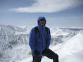
For most of our hike we could not see San Luis because it was surrounded by a thick cloud. We were able to snap this next photo showing one lonely person on the summit. San Luis hidden in the fog. One lonely soul on top.
We finally made it to the summit, I think around 10:00 am. There was one other hiking group already up there. Man, it must be a busy weekend. Oh yeah, duh, it is a holiday. No wonder there are sooo many people out here (sarcastic). I have actually heard that on any other random day you could be the only group out here hiking. San Luis is the least hiked mountain of all the 14ers. Summit shot. The 14er offcial marker is over by those rocks. San Luis offical marker
Our dog ended up falling asleep in Matt's arms. So Cute! She must have been wiped out because this has never, ever happened before. She is an extremely hyper breed...so it was quite shocking to see her fall asleep in that position. So tired...
Here are a few other dog pictures. Asia looking towards the descent; Baldy Alto in the background
We didn't end up getting to eat our lunch because our sandwiches were soggy and moldy. So we decided to head out to try to beat any incoming rain. We were able to see San Luis on our descent with a clearing from the clouds. As soon as we got into the forest it started to pour. Lucky for us we had our raincoats. It rained for the last 2 miles of our hike. San Luis from our descent Rained out
Overall, I really enjoyed our trip once we started hiking. The drive in was horrible and the car camping with our dog the night before was restless. Loved the hike though! I guess you can see Wetterhorn and Uncompagre from the top on a clear day. I would sum up the hike to San Luis to be gorgeous, long and secluded. Even though I loved San Luis, I dont think I will be back to hike this peak again because it was just too much work to get to it and too far away. I'm definitely tagging this one as a "one-time-only" peak for me.
Thumbnails for uploaded photos (click to open slideshow):
Thanks for the trip report! My dad and I did San Luis last weekend and enjoyed it very much. It is quite a long hike through the valley up to the ridge. On the way down it gets a bit discouraging as you just keep going! Nevertheless, the views from the top were amazing! Keep on climbing.
Caution: The information contained in this report may not be accurate and should not be the only resource used in preparation for your climb. Failure to have the necessary experience, physical conditioning, supplies or equipment can result in injury or death. 14ers.com and the author(s) of this report provide no warranties, either express or implied, that the information provided is accurate or reliable. By using the information provided, you agree to indemnify and hold harmless 14ers.com and the report author(s) with respect to any claims and demands against them, including any attorney fees and expenses. Please read the 14ers.com Safety and Disclaimer pages for more information.
Please respect private property: 14ers.com supports the rights of private landowners to determine how and by whom their land will be used. In Colorado, it is your responsibility to determine if land is private and to obtain the appropriate permission before entering the property.


 The miles from this sign and 14ers.com dont match. Hmmm???")
 Beaver pond")
 Baldy Alto, San Luis sits behind it")
 The long valley")
 Scree section, San Luis to the left.")
 Looking back at what we just crossed.")
 At the top of the ridge")
 Pointing out San Luis.")
 San Luis hidden in the fog. One lonely soul on top.")
 Summit shot.")
 The 14er offcial marker is over by those rocks.")
 San Luis offical marker")
 So tired...")
 Asia")
 looking towards the descent; Baldy Alto in the background")
")
 Rained out")
 San Luis from our descent")