Download Agreement, Release, and Acknowledgement of Risk:
You (the person requesting this file download) fully understand mountain climbing ("Activity") involves risks and dangers of serious bodily injury, including permanent disability, paralysis, and death ("Risks") and you fully accept and assume all such risks and all responsibility for losses, costs, and damages you incur as a result of your participation in this Activity.
You acknowledge that information in the file you have chosen to download may not be accurate and may contain errors. You agree to assume all risks when using this information and agree to release and discharge 14ers.com, 14ers Inc. and the author(s) of such information (collectively, the "Released Parties").
You hereby discharge the Released Parties from all damages, actions, claims and liabilities of any nature, specifically including, but not limited to, damages, actions, claims and liabilities arising from or related to the negligence of the Released Parties. You further agree to indemnify, hold harmless and defend 14ers.com, 14ers Inc. and each of the other Released Parties from and against any loss, damage, liability and expense, including costs and attorney fees, incurred by 14ers.com, 14ers Inc. or any of the other Released Parties as a result of you using information provided on the 14ers.com or 14ers Inc. websites.
You have read this agreement, fully understand its terms and intend it to be a complete and unconditional release of all liability to the greatest extent allowed by law and agree that if any portion of this agreement is held to be invalid the balance, notwithstanding, shall continue in full force and effect.
By clicking "OK" you agree to these terms. If you DO NOT agree, click "Cancel"...
Mount Sneffels - 14,150 feet (4,312 Meters for those who are interested!)
Route: East Slopes to Lavender Col, Class II+ with Class IV variation, Moderate Snow
Trailhead: East Dallas Creek
Base Camp: Blaine Basin
Distance and Elevation: From East Dallas Creek TH- 10 miles, 4,810 feet elevation gain
Climbing party: Steve Wilfong (SteveVets), Kevin Baker (as himself) and Mark Milburn (Yog to some)
Mount Sneffels is the 27th highest peak in Colorado. While this mountain is not the highest in the San Juan mountains (however, it is the high point of Ouray County), it certainly is a monarch and dominates the Dallas Divide area. While I'm not sure who exactly named this mountain, I do know that it was named after a volcano in Iceland named Mount Snaefell. I learned, with a little research, that this mountain (the original Icelandic volcano) was also featured in the famous classic Jules Verne novel, "Journey to the Center of the Earth", which was one of my favorite movies growing up as a kid. Not being aware of Leave No Trace principles as a youngster, I would frequently wander around carving the Roman Numeral "III" into rocks that were unfortunate enough to be in my path when wandering around the foothills near Pine, Colorado. I fortunately learned these mountain ethics before I could be lynched.
Mighty Sneffels from Ouray County 7 (Dallas Creek Road)
Steve and I had been talking for a couple of months regarding climbing the Snake Couloir on Mount Sneffels and decided that Memorial Day Weekend would work for both of us. Prior to leaving for Gunnison on Friday, I heard from Kevin Baker who wanted to join us for this climb after climbing Gladstone Peak on Saturday. We thought this sounded great and told Kevin we would meet him at camp or near the base of the climb, depending on the time it took him to make his way up Blaine Basin on Sunday morning.
After hearing about certain difficulties involving bushwacking and river crossing up to Blaine Basin, we decided to head in Saturday morning so that we could 'enjoy' the approach and climb this magnificent peak on Sunday. While driving in to the East Dallas Creek Trailhead on Ouray County 7 road, I was reading aloud Roach's directions to the trailhead when I read, "The views of Sneffels from here are remarkable". Indeed, true words which became quite the standing joke for the weekend between Steve and myself, as many things became remarkable or unremarkable, and many variations thereof. It was the source of much hypoxic laughter for the both of us! Apologies in advance for the unremarkable puns contained in this report.
Sneffels Range or Dallas Divide
Postcard Sneffels
Steve signs into the register
We made our way up the trail past the first of four crossings of Wilson Creek. This first crossing is about 100 yards past the trailhead register and has a sturdy bridge constructed over it. This was the most straightforward of the crossings that we encountered. We followed the old road/atv/trail for about a half hour and came to the second crossing. The trail was washed out and the current was high and strong. We remembered reading that if the crossing looks unmanageable, look around and find a more suitable crossing. So we started looking downstream and found a dubious, half-rotted log that looked like it MIGHT hold our weight across, that is, if we didn't trip up over all the half-broken branches scattered along it. We decided that one of us would cross and throw our packs to the other person on the other side of the river, just in case our "bridge" broke or we fell in, all of our gear would not be soaked. I had nightmarish visions of two climbers hobbling around the riverbank holding their thrown-out backs while trying to get dry... I quickly blocked out these fiendish mental images and agreed to give it a shot! The picture below really does the river /creek/raging-fury no justice at all. Not something you want to jump into, pack or no pack.
Just say no to rotted log river crossings
Steve, in his youthful, immortal and Spartan-like ambiance, decided to go first. I agreed and we set about preparing for the crossing. Steve got up on the log, took a few steps out onto the now precariously bending log, and then hastily developed Elvis Leg. He then turned back, got off the log, and we decided to scout around more. We had serious doubts about this approach now and thought we may have to retreat and head to Yankee Boy Basin. After a short conversation that may be summed up by "F that", Steve started searching upstream and disappeared from view for a time being.
The next time I saw Steve, he was across the river, hooting and hollering that he'd found a way across! We grabbed our gear, and headed upstream to the "official" crossing (two logs lashed together with wire). We could not see the trail that led to this crossing as it was covered with snow. The next two crossings were found with much less difficulty, although the third crossing had a freshly-fallen pine tree across it, which made for an interesting and sappy crossing.
Shortly after the sign that read "Blaine Basin 1 Mile", the trail steepened up a ravine and then took a sharp turn to the south, contouring the steep slope towards Blaine Basin.
Waterfall along Blaine Basin Trail:
I would say that this part of the approach could arguably be the crux of the whole climb, as it was a mixture of side-hilling hardpacked snow with a dire & grim runnout, or postholing suddenly up to your hips and wallowing about. Eventually we wisened up and took off our snowshoes and traded these for ice axes and crampons. Not the greatest fun to be sidehilling with 50 pounds on your back, sinking, sliding and teetering around while trying not to crampon your calves.
Sidehilling from Hell
Needless to say, there were a few sordid exclamations proclaimed throughout this ardous mile, but we did eventually make it and dropped our packs at one of the best campsites I've ever been at. The approach was finally over and we sat around ogling the amazing Cirque Mountain and of course, the majestic and highly remarkable Mount Sneffels.
We meandered around and prepped for our climb, filtered water, and threw in the occaisional remark about how remarkably beautiful the basin was.
I took a few zoomed shots of the upper part of the Snake Couloir so that we could check out the shots. We did not like the looks of the finish on the Snake, as it was corniced and there appeared to be a lot of snow and ice on the reported class 5.5 summit pitch.
Zoom in Snake beta
While I have led some easy 5.5 rock before, 5.5 rock covered with snow and ice with a 2,000 foot runnout was not something I was entirely comfortable with. The 4th class traverse was definitely out as it was heavily corniced and appeared quite dangerous. It took about 10 or 15 minutes of conversation for us both to come to terms with the fact that this route was not going to go. We both strongly felt that a couloir this serious needs to be in good condition to be climbed, and neither of us felt that these conditions were boding well for a safe ascent. We both agreed that we would climb the East Face route to Lavender Col, and ascend the standard route from there. I wrote a note in the snow for Kevin along the trail leading into the basin. I hoped to make the snow-note obvious and large so that he would see it and not ascend the Snake Couloir in trying to catch up with us. I then started wandering around and taking way too many pictures of random objects of remarkable beauty, as is par for me.
Snuggling Shrooms
We cooked our remarkably delicious dehydrated food and commenced to ooh and ahh at the setting sun's color extravaganza. We had quite the front door view from our tent!
A remarkable view from our front door
Photogenic peak seen from Blaine Basin
After a couple of games of cards, we doused the headlamps and awaited the early morning wakeup alarm of 4:00 am (we were aiming for a 5 am departure time as Kevin was due to arrive at camp at 5, and if not, we would begin our ascent without him while keeping an eye out to make sure he knew we were not climbing the Snake).
Steve & I pose on our water filtering island
Fiery alpenglow on Sneffels
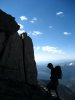
Steve and I quickly ascended to the upper ramps of Sneffels apron when we spied a lone climber entering the basin below us. We figured this was Kevin and tried to get his attention, but he was still far away and I don't believe he heard us over the roar of the numerous creeks that were still chattering away in the pre-dawn morning. Kevin eventually saw us as he crested the lower part of the apron and made his way toward us.
Me in front of Sneffels in the morning light
The sun peaks over the ridge to the west
Cirque Mountain looms as second in command over this area
I thought this was pretty interesting and worthy of making this report. Appeared to be a fallen chunk of snow, landing on top of the dust-ridden snow, and slowing the melt process of the snow below it due to the fact that it was relatively free of dirt and was reflecting the sunlight, vs absorbing it and melting. But what do I know, see for yourself!
Steve does a Leonidas (Sparta!) impression. Careful with that axe, Eu...er, Stephen!
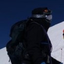
Steve and I stopped at the base of the east slopes ramp (12,400 feet) that led up the the Lavender Col (13,500). It was here that Kevin caught up with us and we all exchanged greetings and geared up with the appropriate snow climbing tools of the trade (crampons & ice axes).
Myself, Kevin, and Steve
We started up the eastern slope, (making remarkable time) and all the while being blown away by the highly remarkable views of Potosi, Tea Kettle, and other notoriously San Juan peaks!
Steve & Kevin heading up towards Lavender Col
The beautiful view west
I would say this slope was not much greater than 30-33 degrees. The sun at this point was INTENSE and the snow was starting to soften up a little bit. In a short while, we reached the Lavender Col and surveyed our route remaining to the infamous and slightly remarkable V Notch.
Kevin on top of Lavender Col
Steve and Kevin head up the final, steeper couloir (filled with nasty scree in the summer)
We were all feeling good and made short work of this couloir. We soon found that the V Notch was impassible, requiring some class IV snow and rock scrambling near the top of the couloir at roughly 14,030 feet.
Snow filled V Notch
Class IV scramble to get around V Notch blockage
Kevin climbing the crux
Upper part of the Snake Couloir, this picture shows the dangerous and exposed conditions of the traverse. A definite no-fall zone. These are the conditions that put us on the East Slope. A bit out of our range of "acceptable risk".
Soon, we were through this bit of spicy scrambling through snow and rock. Now, the final pitch to the summit was in view.
View to the summit from the top of the standard couloir
It was a pretty intense looking finish with some exciting exposure below our feet, under which was air, snow, rock, and Yankee Boy Basin.
Steve with the final summit pitch behind him
Mighty & foreboding Dallas Peak, Wilson group is in background
Kevin on the final summit pitch
We carefully picked our way to the summit, congratulated each other, and began the replenish our bodies with some food and energy, all the while soaking in the incredible San Juan views. I was quite happy to have some good views after my last San Juan summit of Uncompaghre was a whiteout.
Steve on the summit, looking down over the Snake Couloir finish
Summit shot with Kevin & I
Kevin surveys the view looking north towards Montrose
After a few obligatory hero shots, some remarks about Sparta and Spartans (an ongoing topic between Steve and I on the ascent), a video question regarding the origin of 'crampons' for YouTube's "Hot for Words" (video request by Steve), and a few other summit antics, and last but not least, remarking on how utterly remarkable the San Juan views were, we began our descent.
Tea Kettle Mountain conditions from the summit
The downclimb class IV scramble was interesting but not too bad if you're comfortable scrambling on snow and rock while wearing crampons.
Steve downclimbing crux (4th class = facing in downclimb)
We quickly plunge stepped down the couloir, encountering a few postholes on the quickly slurpifying snow. I was surprised to see more people heading up, but thought that if they hurried, they should still be ok. For us, however, it was time to be off the snow.
View down to Lavender Col
Finally back at the Lavender Col, the crampons came off and the glissading began! It was one of the easiest and quickest descents off the mountain and back to base camp that I've ever had. In fact, I think it was the most fun I've ever had while completely ripping out the seat of my pants and freezing my bum off in the process of a yahoo filled descent! All in all, quite a remarkable glissade
Glissade tracks and people below the snake (look close for 2 black dots under Snake start)
We quickly packed our gear up and watched a group of 4 ascend up to base of the Snake Couloir. We could not believe they were still ascending the upper apron at this time of the day (it was around 1:00 pm). We watched this party for a bit, two of them decided to go down, while the other two just sort of hung out under the fall line of the Snake. Kevin decided to head back to the trailhead as he was off to climb some more 13ers in the area. We said our goodbyes and finished packing up. Finally, the late ascending party appeared to be headed off of the mountain much to our relief. We had no wishes to see anything bad happen after this incredible day of climbing.
The 1st mile out of the basin was again a gruelling mix of postholing and sketchy side-hilling, but we knew what to expect this time, and it wasn't quite as bad as the way in.
If you are looking for a climb on this beautiful mountain along a route less travelled, yet more remote and difficult than the standard route, this is for you.
The following are a few shots I took on the way out. Thanks for reading and putting up with the quite unremarkable puns! (I think I may never use the word 'remarkable again')
Fluffy flowers and sun photo
Take me home, country roads ;-)
Thumbnails for uploaded photos (click to open slideshow):
Fine job on the report, Mark! You sure have a knack for taking some good shots. I must say that sure was a LONG 3.4 mile approach! Thanks for the postholes and skid marks on the sidehill traverse so I didn‘t have to break out the axe and crampons. Coming down I realized just how exposed it was in spots!
Your photos are well composed and striking in their beauty. You also did a great job with the prose. I loved the report; congratulations in the summit.
Great story, Yog. It reminds me of all the bad things I did as a kid in the mountains. I sometimes wonder, typically when I‘m in a precarious position, when and if the mountain is going to collect its debt, and whether I‘ve earned enough karma points in recent years to pay that debt. I sure hope so.
Sneffels moved up to one of the top three of my favorite climbs on 14ers. I tried to portray the beauty experienced up there, especially for some of my friends who are unable to climb these mountains. The pictures try, but we all know they do no justice to these peaks! Too bad on the Snake, but it will be there next time and in condition in a couple of weeks I‘m sure
Sorry the Snake didn't quite pan out for you, looks like you put a good day together nonetheless. I was under the impression Sneffels was named by Icelandic miners who worked in the area, presumably they named it after the peak that guards the center of the Earth in Jules Verne's book. Anyway I could be wrong, but that's what I heard. Thanks for the TR!
The ”more” is what I expected--a solid TR with great photos.
Caution: The information contained in this report may not be accurate and should not be the only resource used in preparation for your climb. Failure to have the necessary experience, physical conditioning, supplies or equipment can result in injury or death. 14ers.com and the author(s) of this report provide no warranties, either express or implied, that the information provided is accurate or reliable. By using the information provided, you agree to indemnify and hold harmless 14ers.com and the report author(s) with respect to any claims and demands against them, including any attorney fees and expenses. Please read the 14ers.com Safety and Disclaimer pages for more information.
Please respect private property: 14ers.com supports the rights of private landowners to determine how and by whom their land will be used. In Colorado, it is your responsibility to determine if land is private and to obtain the appropriate permission before entering the property.


")


")


")

")

")
 Mighty Sneffels from Ouray County 7 (Dallas Creek Road)")
 Sneffels Range or Dallas Divide")
 Postcard Sneffels")
 Just say no to rotted log river crossings")
 Sidehilling from Hell")
 Zoom in Snake beta")
 Snuggling Shrooms")
 A remarkable view from our front door")
 Steve & I pose on our water filtering island")
 Fiery alpenglow on Sneffels")
 The sun peaks over the ridge to the west")
 Cirque Mountain looms as second in command over this area")
 Myself, Kevin, and Steve")
 Steve & Kevin heading up towards Lavender Col")
 The beautiful view west")
 Steve and Kevin head up the final, steeper couloir (filled with nasty scree in the summer)")
 Snow filled V Notch")
 Class IV scramble to get around V Notch blockage")
 Kevin climbing the crux")
 Steve with the final summit pitch behind him")
 Mighty & foreboding Dallas Peak, Wilson group is in background")
 Kevin on the final summit pitch")
 Steve on the summit, looking down over the Snake Couloir finish")
 Summit shot with Kevin & I")
 Tea Kettle Mountain conditions from the summit")
 Steve downclimbing crux (4th class = facing in downclimb)")
 View down to Lavender Col")
 Glissade tracks and people below the snake (look close for 2 black dots under Snake start)")
 Fluffy flowers and sun photo")
 Take me home, country roads ;-)")