Download Agreement, Release, and Acknowledgement of Risk:
You (the person requesting this file download) fully understand mountain climbing ("Activity") involves risks and dangers of serious bodily injury, including permanent disability, paralysis, and death ("Risks") and you fully accept and assume all such risks and all responsibility for losses, costs, and damages you incur as a result of your participation in this Activity.
You acknowledge that information in the file you have chosen to download may not be accurate and may contain errors. You agree to assume all risks when using this information and agree to release and discharge 14ers.com, 14ers Inc. and the author(s) of such information (collectively, the "Released Parties").
You hereby discharge the Released Parties from all damages, actions, claims and liabilities of any nature, specifically including, but not limited to, damages, actions, claims and liabilities arising from or related to the negligence of the Released Parties. You further agree to indemnify, hold harmless and defend 14ers.com, 14ers Inc. and each of the other Released Parties from and against any loss, damage, liability and expense, including costs and attorney fees, incurred by 14ers.com, 14ers Inc. or any of the other Released Parties as a result of you using information provided on the 14ers.com or 14ers Inc. websites.
You have read this agreement, fully understand its terms and intend it to be a complete and unconditional release of all liability to the greatest extent allowed by law and agree that if any portion of this agreement is held to be invalid the balance, notwithstanding, shall continue in full force and effect.
By clicking "OK" you agree to these terms. If you DO NOT agree, click "Cancel"...
Details
Total Distance: 10.5mi (Winter closure below Leadvick)
Elevation Gain 3,100ft
Trailhead Time: 9:00am
Summit time: 1:26pm
Completion Time:5:07pm
Total Time: 8 hours
Weather
The weather was almost surreal throughout the hike. From sunrise all the way to sunset, the temperature never dropped lower than about 28 degrees. I would estimate that it was even warmer during the day. There were a few segments of climbing, especially on the snow, where I rolled up my sleeves because it was so warm. Wind was worst on the summit, and was no more than 10 to 15mph. Definitely better than when I was on the mountain back in July!
The Hike
Originally, I had blocked off January 16, along with a number of other Saturdays in January, as climbing days, hoping to get a higher winter 14er count. Fresh off a summit of Elbert on the 9th, I started the work of getting a hike plan together for Mt. Sherman. Thinking I'd need to be back in Denver by 4pm, I was ready to scrap my plans when I received word that my schedule had cleared. While sitting at school wrapping up work on that Friday, Travis (Travis19877) showed some interest in making Sherman his first 14er. By the next morning, we had all of our gear together, and took off for Fairplay.
The first challenge of the day was the last 100 feet of the road up to the winter closure. The road, while drivable by cars with 4WD, is not very easy to turn around on. It took us almost 1.5 hours to turn the vehicle around, a process that involved turning in small increments while digging out the tires at every turn. Finally, at around 8:40, we finally began a push to the summit.
We had snowshoes on up to Leadvick mine where we stowed them, realizing that between the wind and warm, they would accomplish no good what so ever. After quickly making our way to the gate, I decided against my original plan of attempting the snow route listed on 14ers.com in favor of following the tracks the group ahead of us had left. We worked our way up the road almost all the way to Hilltop mine. At 12,730, we took a snow route up to cut off the last switchback on the road below the mine.
Looking into South Park from the ridge on Mt. Sherman
After a break at the mine, the group ahead of us picked one line of snow to the ridge, another hiker behind us chose another line, and we chose a third. As usual out in the field, there is always room to learn. Today's lesson? Carefully study the TOP of your line before beginning the bottom. After running out of snow, Travis and I were faced with a few hundred feet of climbing on loose scree slopes back up to the ridgeline. With that behind us, we were able to make a beeline to the summit, where Travis gained his first 14er summit, and first in the winter. It was my 44rd summit (with repeats) and 3rd winter summit.
Success!
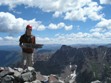
Me on the summit
Travis on the summit
Torreys Peak and Grays Peak
Pikes Peak
Looking south into the Sangre de Cristo range - Crestone Peak's double summit is visible. To it's right is the rounded summit of Kit Carson.
Mt. Elbert
Mt. of the Holy Cross
Another hiker descending off of the summit
The remainder of the day was enjoyable, albeit slow. Travis, being new to the sport, was dealing with some significant muscle pain in one of his hip flexors and one of his calves. I reassured him that the pain is reasonably expected given the amount of exercise we were doing, especially kicking in steps up the snow route. Thankfully, our rather fast ascent allowed time for a slow downhill. The views remained just as amazing as always. We enjoyed a glissade down from the Sheridan-Sherman saddle (13,132ft) into the Hilltop mine area (12,920ft), and then from the mine (12,894ft) all the way down to 12,617ft. From there, the remainder of the downhill went smoothly.
Glissade route
Mt. Sherman
We closed out the day with a trip to the Pizza Hut in Fairplay, where we enjoyed a large meat-lovers pizza for $10. How can you beat that?
GPS Log. Blue represents the standard summit route, while red is our ascent and descent routes.
Thumbnails for uploaded photos (click to open slideshow):
Nice to meet you guys up there. I can‘t believe I took the snowshoes and my heavy brown coat all the way up to the top! I was fine in my softshell and a base layer the whole way!
Good work on Sherman, thanks for the informative photos and writeup. I can relate to your TR‘s title, tough to believe it‘s winter around here these days!
Caution: The information contained in this report may not be accurate and should not be the only resource used in preparation for your climb. Failure to have the necessary experience, physical conditioning, supplies or equipment can result in injury or death. 14ers.com and the author(s) of this report provide no warranties, either express or implied, that the information provided is accurate or reliable. By using the information provided, you agree to indemnify and hold harmless 14ers.com and the report author(s) with respect to any claims and demands against them, including any attorney fees and expenses. Please read the 14ers.com Safety and Disclaimer pages for more information.
Please respect private property: 14ers.com supports the rights of private landowners to determine how and by whom their land will be used. In Colorado, it is your responsibility to determine if land is private and to obtain the appropriate permission before entering the property.


")
")
")
")
")
")
")
")
")
")
")
")
")