Download Agreement, Release, and Acknowledgement of Risk:
You (the person requesting this file download) fully understand mountain climbing ("Activity") involves risks and dangers of serious bodily injury, including permanent disability, paralysis, and death ("Risks") and you fully accept and assume all such risks and all responsibility for losses, costs, and damages you incur as a result of your participation in this Activity.
You acknowledge that information in the file you have chosen to download may not be accurate and may contain errors. You agree to assume all risks when using this information and agree to release and discharge 14ers.com, 14ers Inc. and the author(s) of such information (collectively, the "Released Parties").
You hereby discharge the Released Parties from all damages, actions, claims and liabilities of any nature, specifically including, but not limited to, damages, actions, claims and liabilities arising from or related to the negligence of the Released Parties. You further agree to indemnify, hold harmless and defend 14ers.com, 14ers Inc. and each of the other Released Parties from and against any loss, damage, liability and expense, including costs and attorney fees, incurred by 14ers.com, 14ers Inc. or any of the other Released Parties as a result of you using information provided on the 14ers.com or 14ers Inc. websites.
You have read this agreement, fully understand its terms and intend it to be a complete and unconditional release of all liability to the greatest extent allowed by law and agree that if any portion of this agreement is held to be invalid the balance, notwithstanding, shall continue in full force and effect.
By clicking "OK" you agree to these terms. If you DO NOT agree, click "Cancel"...
We've been trying to plan a Shasta trip all summer, but due to life, the schedule has been pretty full. This weekend was a three day weekend (thanks, Mormons) due to the Pioneer Day holiday, and despite the fact that it happens to fall the week before my thesis defense, we decided we should get out and get it done.
We selected the Hotlum-Wintun route to cut crowds and also in hopes of getting in some summer skiing. We left SLC at 6 pm on Thursday night and drove all night, reaching the McCloud ranger station at 4 am, where we caught a few hours of sleep so we could drive to the trailhead during the day. At 7:30 am, we headed out on dirt roads, arriving at the Brewer Creek trailhead at around 9:00 am. The hike in afforded us some excellent views of our route
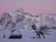
On Friday, we hiked somewhere around 3 K vertical and several miles, camping in a really sweet spot in the snow that would put us in perfect position to head out early in the morning. The sun started to disappear behind the peak by around 6 pm, so we had to hurry to dig out our tent.
Near record highs were anticipated this weekend, and we had planned on heading up at around 1 am to make sure we hit the summit before the snow softened too much, but we spent a lot of time digging out the tent and boiling water, so we didn't get to bed until nearly 10:30 pm.
I couldn't believe how long it took the water to boil. This must be the problem that the Jetboil has with altitude. I keep hearing about it, but this is the first time it's been an issue.
We got up at 2:30 am, ate breakfast, and headed up. We spent too much time walking on scree, which was difficult in the dark with ski boots and minimalist headlamps. I was very excited to get to snow and throw on the crampons (~ 4:30 am?).
I've used crampons before, but only once or twice, so this was a crash course of sorts in climbing a mountain with crampons on.
The sunrise was absolutely incredible.
We chose our up-route poorly. We should have continued up the snowfield that we skied down, but from camp it looked like the snow to the left of the H-W ridge was contiguous. In reality, it was not, so we probably wasted an hour on the way up transitioning from crampons to no-crampons and stumbling around on the loose, volcanic rock.
The snow was pretty decent for the climb. It didn't get a hard freeze the night before, but it remained firm until we were only a few hundred vertical feet from the summit. Some places had fins of snow that were frozen solid with runnels on either side, and some of these fins went up to my knees. Climbing these would have been exhausting even without the altitude. The last few hundred feet to the summit seemed to take FOREVER!
I've been told about how crowded the summit is, so when we stopped for a short rest a few hundred feet below the summit, I decided to take advantage of the solitude of our route and find a place to pee. We had not seen another person on our trip since a sketchy gas station in California on Thursday night, so of course as soon as I drop my pants a guided group of 3 waltzes over the summit and heads down toward my bare ass. Thanks, guys.
We finally hit the top at around 12:30, which was later than planned, but the snow was still ok. We hung out with our skis and took a ten minute power nap and then headed over a few hundred yards for a peek at the true summit, which was crowded. The boys on top expressed surprise and disbelief when they saw our ski boots. I was the only girl (which I thought was surprising).
FINALLY... ready for the ski down. The snow was pretty sick for the end of July. We hung to the left to avoid the many half-melted boot ladders up the mountain. We had at least 1000 feet of decently smooth snow near the top.
We did have to cross one belt of scree, but we crossed it in a relatively flat location and got to another snow field, which was also AMAZINGLY flat for another 1000 ft.
When we got to the very bottom of the snowfield, the sun cups got decently large, and we decided that walking back to camp was the best way to avoid an injury. It wasn't far, and on the way we found running water which we treated with iodine to avoid melting more snow.
The ski/walk down took a little over an hour, and we were back to camp by 3:00. We had the opportunity to watch the shadow of Shasta spread across the valley below (so cool).
Image #18 (not yet uploaded)
We headed to bed early and left camp Sunday morning by 8:30 am. We got to the trailhead by 11:30 and drove back to Salt Lake.
This photo shows our route on summit day. Blue- up, Red- down.
Great trip, fun route. I highly recommend it. We saw another group of 4 people headed up the H-W route as we were skiing down, but besides that group, the guided group, and the 10 or so people on the summit who came up Avalanche Gulch, we didn't see anybody the entire time!
Thumbnails for uploaded photos (click to open slideshow):
How was the trail into where you base camped (around 9,500 feet I assume)? I plan climbing in early semptember but may be hiking in on friday night in the dark via headlamp.
Caution: The information contained in this report may not be accurate and should not be the only resource used in preparation for your climb. Failure to have the necessary experience, physical conditioning, supplies or equipment can result in injury or death. 14ers.com and the author(s) of this report provide no warranties, either express or implied, that the information provided is accurate or reliable. By using the information provided, you agree to indemnify and hold harmless 14ers.com and the report author(s) with respect to any claims and demands against them, including any attorney fees and expenses. Please read the 14ers.com Safety and Disclaimer pages for more information.
Please respect private property: 14ers.com supports the rights of private landowners to determine how and by whom their land will be used. In Colorado, it is your responsibility to determine if land is private and to obtain the appropriate permission before entering the property.


")


")
")
")
")
")
")
")
")
")
")
")
")
")
")
")
")