Download Agreement, Release, and Acknowledgement of Risk:
You (the person requesting this file download) fully understand mountain climbing ("Activity") involves risks and dangers of serious bodily injury, including permanent disability, paralysis, and death ("Risks") and you fully accept and assume all such risks and all responsibility for losses, costs, and damages you incur as a result of your participation in this Activity.
You acknowledge that information in the file you have chosen to download may not be accurate and may contain errors. You agree to assume all risks when using this information and agree to release and discharge 14ers.com, 14ers Inc. and the author(s) of such information (collectively, the "Released Parties").
You hereby discharge the Released Parties from all damages, actions, claims and liabilities of any nature, specifically including, but not limited to, damages, actions, claims and liabilities arising from or related to the negligence of the Released Parties. You further agree to indemnify, hold harmless and defend 14ers.com, 14ers Inc. and each of the other Released Parties from and against any loss, damage, liability and expense, including costs and attorney fees, incurred by 14ers.com, 14ers Inc. or any of the other Released Parties as a result of you using information provided on the 14ers.com or 14ers Inc. websites.
You have read this agreement, fully understand its terms and intend it to be a complete and unconditional release of all liability to the greatest extent allowed by law and agree that if any portion of this agreement is held to be invalid the balance, notwithstanding, shall continue in full force and effect.
By clicking "OK" you agree to these terms. If you DO NOT agree, click "Cancel"...
Tabeguache Peak (14,155') and Mt. Shavano (14,229') July 24, 2009
Route: Tabeguache WEST RIDGE ascent, with descent from Shavano to the Angel of Shavano Trailhead.
Elevation Gain: ~4,100'
Total Hiking Distance: 12 Miles.
Amy (shredthegnar10) and Keith
Special thanks to Aaron Johnson on Summitpost.org*, who took the time to describe this route and champion Tabeguache Peak as a very enjoyable, worthy mountain.
Mt. Shavano has not been kind to me. Three times I've set out to climb it from the Shavano/Tabeguache trailhead, and three times I've returned home without even a serious look at the summit. This past spring, an attempt to climb the Angel of Shavano couloir met with frustration, and illness, as one of my partners reported that "I feel weird. I think I broke my brain." I think he was just fed up with the mountain. On the return, we gave it a nickname, which is inappropriate to state here, but very appropriate for the way we felt that day. I was sure that I would NOT return to climb Mt. Shavano from the east side...
The Jennings Creek Route for Tabeguache Peak was closed by the Forest Service in 2002, citing heavy erosion and damage along the trail to Tabeguache's West Ridge. However, this damage occurs high above tree line, and the first half mile or so of the trail is like any other Sawatch trail, meandering through aspen groves and eventually reaching the mouth of the Jennings Creek valley. It is at this point, near a small tarn, that a manageable, sustainable route can be had to climb these peaks from the west. The old, closed route looks a lot less fun that the one I will describe here. I hope that my intentions are clear, to express the adventure and beauty to be had by following Jennings Creek, NOT the closed Jennings Creek Route. I CANNOT EMPHASIZE ENOUGH THE IMPORTANCE OF STAYING AWAY FROM THE OLD ROUTE AS MUCH AS POSSIBLE.
Pyramid Peak and a subsequent attempt to climb Crestone Needle with legs of gelatin encouraged me to spend several days resting and relaxing at home during my vacation, instead of climbing mountains in the Sangre de Cristo Range. In a way, this turned out to be a good thing, as I realized just how pleasant a class two route might be during those times when I'm not quite in the mood to risk my life scaling cliffs and ledges. By Wednesday I was more than ready to make the rest of the week count as much as I could, and the West Ridge of Tabeguache Peak seemed like the perfect chance to exercise my spirit of adventure, as well as exorcize some of those ill-feelings towards its taller neighbor. I talked Amy into joining me, since she was looking for something to do on a Friday, and she had yet to climb it.
We chose the Angel of Shavano Trailhead for a good spot to camp, and then drove one vehicle up to the Jennings Creek Trailhead, which is easy to find if you know what to look for. The Forest Service has attempted to erase its presence by piling some rocks in front of it, and driving tree limbs into the ground to make it blend into the hill side. Someone had chopped out the brush around the start of the trail, though, and it was pretty obvious as we approached it. There is virtually no parking at the trailhead proper; I parked about 30 yards up the road, and there are spaces for about 5 or 6 vehicles a hundred yards or so downhill.
We began hiking up the abandoned trail at 6:40 a.m., a pleasant stroll through the interspersed aspen and pine forest, climbing fairly steeply at times as the path led towards the prominent ridge or buttress that the old route uses on the east side of Jennings Creek. It was not difficult to determine where to leave the trail, as a small tarn appears to the left of the hillside, and the trail points away towards the end of the ridge. This would be the perfect spot for the Forest Service to actually close the trail, and direct the route up the valley. Easy hiking through solid grass mixed with stranded talus provided a welcome change of pace from the dirt and scree trails that we are so used to on most other hikes, and the gentle grade of the terrain allowed for a steady, relaxed pace. The route is simple to follow; stay left of the talus on the uphill side, and right of the willows along the creek bed. Lush vegetation dotted with blooming wildflowers made for a very enjoyable morning.
A lot of effort went into this trail once upon a time...
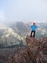
Amy surveys the route ahead as we turn north away from the closed route...
It's not the San Juans, but these Columbines are at least trying...
As we hiked into the basin, the talus slope to the east side steepened, and I chose to cross onto the west side of the willows with a short, easy bushwhack. Winding upstream and below the last of the trees, the route begins to veer towards the lowest point of the saddle between Carbonate Mtn. and Tabeguache. A pair of mountain goats anxiously watched us as we crested the horizon, and began to make their way up valley. As we hiked over the next rolling hill, an even more exciting scene developed, as the rest of the goat herd aborted their morning drink in the bottom of the basin and fled towards their friends, with at least three kids in tow. The large, protective buck stood below the herd, keeping watch of us as we could not take pictures fast enough. What a great sight!
Midway up the valley, bypass the trees by staying low near the willows...
Beyond the last tree, the terrain rolls pleasantly to the ridge...
The big guy at the bottom makes sure we don't get any closer...
Continuing into the upper basin, two routes become apparent. There is an obvious trail developed through talus on the right side that angles up into some rock ribs that can provide class three climbing, albeit potentially loose, or an obvious path up an orange patch of scree at the saddle proper. Our new friends, the goat family, chose the scree, and we did too. It was easy hiking, not overly steep which compensated for the looseness. Within a few minutes we had reached the saddle on the ridge. The goats continued to lead the way, heading straight up the route, as if they wanted us to follow.
A good look at the easy scree trail to the saddle...
An obvious path through the talus is available if scrambling up to the ridge suits your desire...
From the 12,500' saddle, it is a steep but not difficult hike along the ridge towards Pt. 13,935', the first false summit along the ridge. Following the ridge was easy work, and staying on rock the entire time is completely reasonable. Making our way up the ridge, it was simply a matter of choosing the easiest lines, as the views expanded in every direction. The San Juans were even on display through the haze, with Uncompahgre Peak's distinctive shape looming on the horizon. The San Luis Group was obvious, with the Needles and Grenadiers appearing over its shoulder. The Sangre de Cristo Range shot to the southeast, a spine of consistency until the jagged teeth of the Crestone Group snared the eye from wandering further. We had picked the perfect day for this hike.
Beginning the hike up the ridge...
Carbonate Mtn. from the saddle...
Strolling into the sun...
Cronin Peak and Mt. Antero on the north side of Browns Creek...
As the terrain began to climb, we worked our way up and around, sometimes veering to the right (south) side of the ridge. Approaching the false summit, I found that we were too far down on the ridge, and the terrain became loose and dirty, and obvious indication of why the old route was closed. We worked up hill back to the ridge proper, where the talus was much more solid. This was the important part of this route; stay on the ridge crest and avoid the temptation to traverse the south side, as that is where you will encroach upon the closed route. Once past the false summit, the ridge joins with the old trail, and the trail stays close to the ridge crest the entire time to the summit.
Approaching Pt. 13'935', stay on talus and climb directly over it...
A look ahead at the West Ridge proper; join the old route here, beyond the eroded slopes that forced the closure...
Looking back at Pt. 13,935' and the proper route over the talus...
Following the now-cairned route, the hike up the ridge went by quickly, and we reached the rugged, rocky pinnacles that give the mountain its true character. I felt very pleased that we chose this route, as we were seeing Tabeguache Peak from an angle that so many will not, as it appears as a simple pile of talus from the side of Mt. Shavano. What a shame, because outside of Missouri or Massive, this was by far a more interesting "easy" route than other Sawatch peaks. A cliff band guards the final summit pitch, making for an easy class three scramble to reach the top of the peak. Amy chose this line, and I regretfully did not. Instead, I dropped below the difficulty and followed the loose, class two trail up into an even looser scree gully, where a few forceful steps were enough to ascend up and onto the summit. The class three option definitely looked more fun.
Scampering along the ridge with the summit in our sights...
Easy and fun class two rock hopping...
Amy heads directly for the class three option up and over...
My loose class two option...
Pick your line and climb onto the summit!
We arrived on the summit right around 11:10, four and a half hours from the trailhead. Not bad, I thought, for the fact that this route is class two almost the entire way. A pair of hikers had appeared on the summit at 10:00 as we were making our way up the ridge, and were long gone by now. We had this summit all to ourselves on this perfect, sunny Friday. The Crestone Group stood out to the south, and San Luis and Uncompahgre were discernible to the west. Of course, the Sawatch expressed itself to the north, with Ice Mtn., Huron Peak and La Plata Peak easily identified as I pointed the camera to the north west. I really liked the views from this peak.
Uncompahgre Peak exists too far away...
Mt. Ouray is ever present on this hike...
The northern Sangre de Cristo Range...
Mt. Princeton hiding behind the scarred Mt. Antero...
Ice Mtn, North Apostle, Huron Peak and La Plata Peak...
Our next destination, and it's only redeeming factor, the cool northwest ridge...
The descent off of Tabeguache was surprisingly random, as various trail segments seemed to meander down the side of the peak, without any real organization. We worked our way down, criss crossing when necessary. I was also surprised at how long it took to reach the saddle and begin our way up the long, northwest ridge of Mt. Shavano. It was actually a pleasant climb, as large, flat boulders make up most of the ridge, and the rock hopping is easy and fun. It was a stark contrast to climbing up from the standard route. The first marmot of the day came out to play hide and seek, and we spent several minutes taking pictures of the funny little rodent before finishing the climb to the summit.
It's no wonder Tabeguache gets such a bad rap, this side of the mountain is not much to look at, or climb...
Beginning to ascend Mt. Shavano; easy trail gives way to fun boulder hopping...
Amy makes a new friend...
More ridge stomping...
Once again, we had the summit to ourselves, and took advantage of the mild weather to just relax and enjoy the day. I was really appreciative of this hike, and very pleased with our decision to climb Tabeguache from the west. The prospect of re-climbing it and returning to Jennings Creek did not seem pleasant, though, and we were glad to have the car shuttle waiting, even though it would add at least two miles to the hike. At least it would be on a trail almost all of the way out.
The San Juans far off to the southwest...
Okay, so we didn't really have the summit to ourselves...
With nearly seven miles of hiking ahead, we began our descent, passing several hikers on their way up. The weather was holding well, and I don't remember too many Fourteeners where I felt like there was absolutely nothing to worry about except savoring the time on top of the world. It's ironic that the Jennings Creek route is closed due to erosion, as the trail from the saddle down into the body of the Angel has a lot to be desired. It is basically a runoff trough for much of the time, until veering across the right arm and traversing the long, endless slope towards the far off tree line. It takes forever to hike back down to the Colorado Trail.
The familiar view of Mt. Shavano; unless it's to climb the Angel, I don't expect to be back...
An alpine tribute to this year's NBA World Champions!
Finally hitting the Colorado Trail, we were both relieved and actually seemed to pick up our step a bit. The trail is remarkably smooth compared to the rocky and steep Shavano trail, and we hiked south with a steady, comfortable pace. As we dropped off of the hill side above the trailhead, the day provided one more surprise. A black bear plunged away from the trail as Amy startled it, and we watched and listened to it bulldoze its way across the creek bed and up the opposite hillside. This was as close to a bear in the wild as either of us has ever been, and it was a fitting finish to the hike. I wish I could have had my camera handy. Oh well, seeing it with our own eyes is what it's all about, right?
The West Ridge route on Tabeguache Peak was everything I had hoped it would be; a reasonable, pleasant hiking experience with a lot of class two charm and great views. The ridge is interesting and engaging, and I would highly recommend this route to the responsible, conscientious hiker. Respect the closure, and stay off of the old route between the ridge proper and tree line, and enjoy the Jennings Creek basin, it's far more interesting anyway.
An easy finish to a great day!
*Summitpost.org Jennings Creek to West Ridge Route:
why they didn‘t change the old route to be this one. It‘s a great hike and completely avoids the problems of the old route. Thanks for posting the info.
Thanks for this timely report. We are doing this the 3rd weekend of August and were planning to climb from the Brown‘s Creek side. Some want only Tab, one also wants Shavano. Is there camping near the old TH you would recommnd for about 3 solo tents? You lucked out and had a glorious weather day.
I hope we are so lucky!
Beth
Beth, there are lots of spots on the way up the road between the Angel of Shavano Campground and the start of the trail. There is one in particular that would accomodate a few tents, about 2.5 miles up the road from the Angel Campground.
This was a tremendously enjoyable day, and I highly recommend the route.
I remember slogging up that scree slope in 92 and I always wondered if it would have been better to go on up into the valley. That‘s definitely a better route through the valley. Great TR!
.. than I did in 2001. That was a hellacious trip with rock avalanches breaking my fav poles in half and lighting over my head. All because I had to go back over Shavano...
That is an interesting choice for Tab. Never once crossed my mind & after having done Jennings Creek, I think this very well may be the route of choice for Tab solo.
Great shot of the west ridge proper.
Having just finishing Challenger Point and Kit Carson the day before that took me 17 hours, I decieded to followed your route description up Jennings Creek on 9/3/2010 as I had attempted Tab twice before. Once in 2007 after climbing Mt.Shavano, than again in 2009 from Blank Creek after finishing Antero. Both times the weather turn bad before I could finish. After reading your report I decided to try again. What a great day, all to myself, even on the peak. I also found myself getting to far south, something about the shape of the Mt leads you in that direction. If I had any advice to add to your report it would be always keep Browns Creek (to the north) in your eye site. If you cann't see it your heading to far to the south. I would also worn that there is a big cat in the area.
Caution: The information contained in this report may not be accurate and should not be the only resource used in preparation for your climb. Failure to have the necessary experience, physical conditioning, supplies or equipment can result in injury or death. 14ers.com and the author(s) of this report provide no warranties, either express or implied, that the information provided is accurate or reliable. By using the information provided, you agree to indemnify and hold harmless 14ers.com and the report author(s) with respect to any claims and demands against them, including any attorney fees and expenses. Please read the 14ers.com Safety and Disclaimer pages for more information.
Please respect private property: 14ers.com supports the rights of private landowners to determine how and by whom their land will be used. In Colorado, it is your responsibility to determine if land is private and to obtain the appropriate permission before entering the property.