Download Agreement, Release, and Acknowledgement of Risk:
You (the person requesting this file download) fully understand mountain climbing ("Activity") involves risks and dangers of serious bodily injury, including permanent disability, paralysis, and death ("Risks") and you fully accept and assume all such risks and all responsibility for losses, costs, and damages you incur as a result of your participation in this Activity.
You acknowledge that information in the file you have chosen to download may not be accurate and may contain errors. You agree to assume all risks when using this information and agree to release and discharge 14ers.com, 14ers Inc. and the author(s) of such information (collectively, the "Released Parties").
You hereby discharge the Released Parties from all damages, actions, claims and liabilities of any nature, specifically including, but not limited to, damages, actions, claims and liabilities arising from or related to the negligence of the Released Parties. You further agree to indemnify, hold harmless and defend 14ers.com, 14ers Inc. and each of the other Released Parties from and against any loss, damage, liability and expense, including costs and attorney fees, incurred by 14ers.com, 14ers Inc. or any of the other Released Parties as a result of you using information provided on the 14ers.com or 14ers Inc. websites.
You have read this agreement, fully understand its terms and intend it to be a complete and unconditional release of all liability to the greatest extent allowed by law and agree that if any portion of this agreement is held to be invalid the balance, notwithstanding, shall continue in full force and effect.
By clicking "OK" you agree to these terms. If you DO NOT agree, click "Cancel"...
"Failed attempt on Jones Mountain, yet successfully survived"
Whenever someone isn't successful on a climb (due to bad weather/conditions, lack of gear/skills, fear, etc.), people often say, "The mountain will always be there." But that assumes you'll want to go back and give it another shot.
I doubt I'll ever want to retry Jones Mountain. And, thankfully, I'm not out to climb all the Centennial 13ers, otherwise this would be a problem.
After hitting snooze three times I contemplated the fourth. For some reason Jen and I had a hard time getting up. Perhaps all the climbing, 4x4ing and drinking over the previous few days was finally catching up to us.
My stomach wasn't feeling so great, either, which made me wonder about the meat in those meatballs I ate at the Cannibal Grill the night before. So I kept my breakfast simple: a few crackers, two Ibuprofens and two Peptos.
We started up the rough 4WD road before dawn (the off road lights came in very handy for the third day in a row):
Just before sunrise we pulled into the empty Cuba Gulch Trailhead parking area. It didn't look like it gets a lot of traffic.
Even though we parked at the Cuba Gulch Trailhead, we were headed up the Snare Gulch road, which is now permanently closed. From what I've read, it was closed because too many trucks rolled off the road and/or it was just too difficult to maintain.
As we hiked up the road we had to hurdle many fallen trees:
Avalanche aftermath (surprisingly, some of the aspens survived, and now they just live a horizontal life):
This ginormous fallen tree had a massive root system that was just another obstacle in our way:
Not far up the road we encountered our first big pitch up the mountain known as the Snare Stairs -- 12 switchbacks up a steep, talus slope.
I wondered what happened to the driver of this bulldozer/snowplow:
This curious cabin above the Snare Stairs was full of marmot poop:
If you're jonesin' for solitude, then Jones is your mountain. We had the whole basin to ourselves.
A look back down the valley:
Flooded mine at 12,000'; this is where we left the "road" and started bushwhacking up the undulating slope:
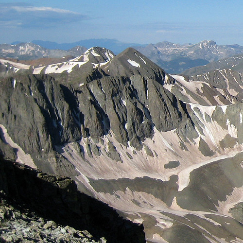
A look at our objective:
Getting closer to the saddle:
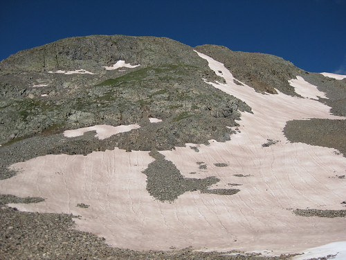
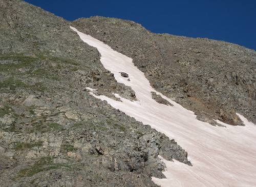
Some easy snow we had to contend with:
The menacing route before us (true summit in the back):
View of Burns Gulch from the Jones-American saddle:
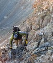
Above the saddle things became a bit dicey. There was a faint trail, if you can call it a trail, but the rock was horrible. I had to test at least four holds for every one I could find that was just solid enough to hang on or step on.
As we climbed, we tried to stay in the sweet spot between the loose crap on the left and the exposed, thousand-foot cliff on the right.
The rock at 13,450' on Jones Mountain's northeast ridge was much worse than anything I've experienced before. It was even worse than the rotten rock on the Bells and Pyramid, in my opinion.
And so, three hours into our climb, I tapped out. It was no longer fun enough to warrant the risk, and it was just too sketchy for my taste. Jen had similar feelings.
We took it very slow down that steep, exposed and rotten slope:
As we climbed down off the ridge I noticed a couple climbers on American Peak. It looked like they were climbing the ridge to Jones. I looked back often, but I lost them somewhere around the Jones-American saddle. Hopefully they made it OK.
Some pics of our descent:
.
Looking down on one section of the Snare Stairs:
As usual, hiking down was much faster than going up. We made it from the ridge to the trailhead in just about two hours.
Back at the trailhead (truck lower-right):
Upper portion of our route:
Jen and I were both fine with this failed attempt. After all, we got in a great hike up a beautiful basin to a scenic ridge. I'm also not out to conquer the world and I've learned to be humble. Besides, there are plenty of other mountains out there just waiting to be climbed. And I'll bet most of them have better rock.
Thumbnails for uploaded photos (click to open slideshow):
Thanks for the timely report, Aubrey. I‘m not looking forward to that loose stuff! Jones is on the agenda for this weekend along with American, Niagara, and a few others. What did the couloirs on American‘s north face look like from Handies? Any of them still in?
Too bad that quad map you bought did not show loose rock. Anyway, glad you and Jen made it safe. It is always assuring to read about unsuccessful attempts when people realize they are outside of their comfort zone.
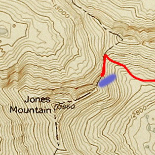
In hindsight, going up snow is probably the better option. Kevin Baker, I‘m not sure if these help or not, but here are a couple shots looking toward American from Handies (taken the previous day):
And we probably should‘ve just taken this small snow route to bypass the steep rock from the saddle (the purple area on the map shows where the snow is in the next 2 photos):
Always interesting to read a trip report and see how different people see a climb. The loose rock going up the ridge of Jones didn‘t really bother me or my partner last weekend. I thought the rock on Niagara was worse. Of course after coming down the north side of Rio Grande Pyramid the weekend before not much could be worse..
You made the right decision though for your comfort level. I definitely agree the side between Niagara and Jones is much better.
Aub, if you ever want to go back, try going up to Niagara first, then over to Jones. With good weather, you can bag the Niagara-Jones-American trifecta!
But if you change your mind, try this one again, from Burns Gulch. I remember doing it that way a couple of years ago, along with (13er) Niagra, and turning down a ride back to camp, and then doing Sneffels the next day - and I‘m a much bigger wuss than either of you guys, so it must have been easy! Dhatfield has a photo album of the route... if/when you‘re interested.
Reading this reminded me of the one time I turned around due to loose rock. It was Gladstone, and I still don‘t regret it, and I don‘t know if I‘ll try that one again, either...
”And I‘ll bet most of them have better rock.” - Not in the San Juans unfortunately! Some of the 13ers in the SJ‘s will have you thinking Wilson is ”solid”.
The ridge on the Niagara side was much more gentle and more grassy, if you ever did decide to give this one another go, traverse around the south part of the mountain on an old road and go up from the west instead, its much more pleasant
Caution: The information contained in this report may not be accurate and should not be the only resource used in preparation for your climb. Failure to have the necessary experience, physical conditioning, supplies or equipment can result in injury or death. 14ers.com and the author(s) of this report provide no warranties, either express or implied, that the information provided is accurate or reliable. By using the information provided, you agree to indemnify and hold harmless 14ers.com and the report author(s) with respect to any claims and demands against them, including any attorney fees and expenses. Please read the 14ers.com Safety and Disclaimer pages for more information.
Please respect private property: 14ers.com supports the rights of private landowners to determine how and by whom their land will be used. In Colorado, it is your responsibility to determine if land is private and to obtain the appropriate permission before entering the property.


")
")
")
")
")
")
")
")
")
")
")
")
")
")
")
")
")
")
")
")
")
")
")
")
")