Download Agreement, Release, and Acknowledgement of Risk:
You (the person requesting this file download) fully understand mountain climbing ("Activity") involves risks and dangers of serious bodily injury, including permanent disability, paralysis, and death ("Risks") and you fully accept and assume all such risks and all responsibility for losses, costs, and damages you incur as a result of your participation in this Activity.
You acknowledge that information in the file you have chosen to download may not be accurate and may contain errors. You agree to assume all risks when using this information and agree to release and discharge 14ers.com, 14ers Inc. and the author(s) of such information (collectively, the "Released Parties").
You hereby discharge the Released Parties from all damages, actions, claims and liabilities of any nature, specifically including, but not limited to, damages, actions, claims and liabilities arising from or related to the negligence of the Released Parties. You further agree to indemnify, hold harmless and defend 14ers.com, 14ers Inc. and each of the other Released Parties from and against any loss, damage, liability and expense, including costs and attorney fees, incurred by 14ers.com, 14ers Inc. or any of the other Released Parties as a result of you using information provided on the 14ers.com or 14ers Inc. websites.
You have read this agreement, fully understand its terms and intend it to be a complete and unconditional release of all liability to the greatest extent allowed by law and agree that if any portion of this agreement is held to be invalid the balance, notwithstanding, shall continue in full force and effect.
By clicking "OK" you agree to these terms. If you DO NOT agree, click "Cancel"...
My friend Danny and I headed up to the Collegiate Peaks area from Denver on Saturday, May 30 to set up camp and climb Mt. Princeton the following morning. Although the Mt. Princeton 4wd road is clear all the way until just before the trail turns off, we opted to make things more difficult for ourselves and start hiking at the bottom rather than driving all the way up to 11,000 feet.
The actual Mt. Princeton Trailhead and Mt. Princeton Road starts at 8,900 ft., but we didn't realize that the Frontier Ranch was located here, so therefore you can't actually camp at this trailhead. We arrived at this point around 6 pm on Saturday during the middle of a heavy rain/hail storm, but luckily it cleared up pretty quickly. There was a guy at the parking lot who worked for the ranch that told us we could drive up the road and camp wherever there was a pull-off, so that's what we did. If you plan to drive this road, it is very narrow and there aren't many places to pull off - only two before the Radio Towers. We stopped at the road's intersection with the Colorado Trail, at about 9,500 ft. and maybe about a mile in, and set up the tent on the pull-off right next to the car, since it was the only flat spot on the steep mountainside.
Our camping spot next to the Colorado Trail
We woke up at 3:45 am on Sunday morning, packed up and ate PB&Js for breakfast, then started hiking up the road around 4:15. The road had a nice, steady grade to it, so we were able to move pretty quickly up to the Radio Towers (about 2.2 miles into our hike). The night sky was amazing when we started, and we even saw a couple of shooting stars. The sunrise over the Arkansas River Valley was also amazing.
Probably the most spectacular sunrise I've seen so far on a 14er trip
It was quickly getting light outside by the time we reached the radio towers, and we got our first views of Princeton just past this point. At and just beyond the radio towers we saw several good camping spots. There's one good place to pull off on the left just past the towers, and a little ways farther up the road, there's a pull-off on the last big switchback shortly before reaching treeline (just past where the van is in the picture below) - there's room for a 2-3 cars to park here, but be warned that this is the last place you can really turn around right now before hitting snow, so make sure not to drive past this point. Also, don't do what the van in the pictures below did...
First view of Princeton just past the Radio Towers
You have to wonder who thought this was a good idea
A large patch of snow is covering where the trail turns off from the dirt road right now, but there is a cairn right before you reach the snow marking an alternate route straight up a small, rock-filled gully that reconnects with the trail after just a few feet.
This is where you leave the road and pick up the trail
Shortly after the turnoff, you'll quickly switchback to the top of a ridge, now above treeline, at around 12,000 feet. Then you'll traverse along the lower slopes of Tigger Peak for a little ways, crossing, as of right now, three snowfields, none of which are difficult. The trail starts out along open tundra before turning very rocky.
Danny with Princeton in the background
I didn't realize I was still wearing my headlamp at the time...oops
Looking at our route across the lower slopes
Snow crossing
After crossing the third snowfield, you'll go a little farther before the trail abruptly begins switchbacking up to the saddle between Tigger Peak and Princeton.
Approaching the saddle between Princeton and Tigger
View of Mt. Antero from the saddle
Once you reach the ridgeline, the remainder of the route follows the ridgeline, though you'll frequently have to scramble along the right side of the ridge. The route is easy to lose at times over the large boulders, but it's pretty straight forward and frequently cairned. There was a bit of new snow on the upper part of the mountain, so if you go in the next couple of weeks (looks like they could get a bit more snow this week), watch your footing for rocks hidden under the snow. Otherwise, it wasn't deep enough to be too much of an issue, and if anything made the route a little more scenic.
Our remaining route along the ridge to the summit
Danny hiking up the ridge
Looking back at our route
Final push to the summit
One really cool thing we saw near the top (my inner weather nerd revealed) was the beginnings of what would later turn into afternoon storms. You could see the moisture being drawn up from below and rapidly forming into a cloud right above us. Pretty cool stuff...but also a good reason why an early summit is important. The skies began to darken especially early on this day.
Weather in the making
At about 9:20 a.m. we reached the summit of Princeton. The last couple of hundred feet were tough, but it was a very rewarding summit, with some fresh snow, beautiful views, and only a light breeze.
Danny taking a well-earned break on the summit
Looking north from the summit
Danny on the summit
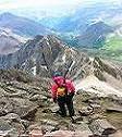
Myself on the summit
Looking down towards the valley
On the descent, we were glad to have ice axes just for balance, but it‘s possible to do this route without one right now if you so choose - other people we saw did not have ice axes, but it's all personal preference. Storm clouds started to form quickly on the way down, even though it was still really early, but we were well off the summit by this point - though it did sleet/hail/snow on us for a few minutes when we were crossing the lower slopes of Tigger. We never heard any thunder or saw any lightning, except for on the drive back to Denver when we saw some awesome lightning driving through the South Park valley on 285.
We made it back to the car around 12:30-12:45, exhausted but in a good way. It was a great hike, and a good early season option since the route has a lot less snow than most peaks seem to have at this time of the year for whatever reason, other than obviously being east-facing. Summer is off to a great start!
Thumbnails for uploaded photos (click to open slideshow):
The photo of the van is great. I have no idea how some one could drive off of the road like that. Perhaps they were trying to execute a 3-point turnaround? Not a good idea! On that road, don‘t drive a vehicle that you are not comfortable driving reverse in for a long distance!
glad my cairn is still on the trail there! we climbed it several weeks ago & about 15 people missed the trail up to your right, so I decided to make a cairn for future climbers.
aconcagua08, thanks for making the cairn, that ended up being very helpful to us ...I‘m sure others who have climbed Princeton recently have also appreciated it.
Caution: The information contained in this report may not be accurate and should not be the only resource used in preparation for your climb. Failure to have the necessary experience, physical conditioning, supplies or equipment can result in injury or death. 14ers.com and the author(s) of this report provide no warranties, either express or implied, that the information provided is accurate or reliable. By using the information provided, you agree to indemnify and hold harmless 14ers.com and the report author(s) with respect to any claims and demands against them, including any attorney fees and expenses. Please read the 14ers.com Safety and Disclaimer pages for more information.
Please respect private property: 14ers.com supports the rights of private landowners to determine how and by whom their land will be used. In Colorado, it is your responsibility to determine if land is private and to obtain the appropriate permission before entering the property.


")
")
")
")
")
")
")
")
")
")
")
")
")
")
")
")
")
")
")
")
")
")
")
")
")