Download Agreement, Release, and Acknowledgement of Risk:
You (the person requesting this file download) fully understand mountain climbing ("Activity") involves risks and dangers of serious bodily injury, including permanent disability, paralysis, and death ("Risks") and you fully accept and assume all such risks and all responsibility for losses, costs, and damages you incur as a result of your participation in this Activity.
You acknowledge that information in the file you have chosen to download may not be accurate and may contain errors. You agree to assume all risks when using this information and agree to release and discharge 14ers.com, 14ers Inc. and the author(s) of such information (collectively, the "Released Parties").
You hereby discharge the Released Parties from all damages, actions, claims and liabilities of any nature, specifically including, but not limited to, damages, actions, claims and liabilities arising from or related to the negligence of the Released Parties. You further agree to indemnify, hold harmless and defend 14ers.com, 14ers Inc. and each of the other Released Parties from and against any loss, damage, liability and expense, including costs and attorney fees, incurred by 14ers.com, 14ers Inc. or any of the other Released Parties as a result of you using information provided on the 14ers.com or 14ers Inc. websites.
You have read this agreement, fully understand its terms and intend it to be a complete and unconditional release of all liability to the greatest extent allowed by law and agree that if any portion of this agreement is held to be invalid the balance, notwithstanding, shall continue in full force and effect.
By clicking "OK" you agree to these terms. If you DO NOT agree, click "Cancel"...
Three days of solitude, isolation and mountains, what could be better?
Four Fourteeners and four thirteeners!
Day 1: Shavano, Tabeguache
Day 2: Antero, North Carbonate
Day 3: Princeton, UR 13971, unknown point, UN ("Avery") 13626
I left Greeley at 7pm on Sunday night for the southern Swatch range and finally arrived at the Shavano trailhead at 1:30am. After a miserable three hours of sleep, I woke to my alarm at 4:15a and began stumbling up the trail. About 2 miles from the trailhead, the trail flattens out and the route becomes somewhat ambiguous though sparse aspen trees. With only five square feet of illumination from my head lap, I could not figure out where the trail continued and realized I was off route. Never give up, never surrender! Knowing that tree line was somewhere to the right and straight up, I made my own route! As the sun rose, I was greeted by tree line and the trail, making the remainder of the route to the summit of Shavano a breeze.
Traversing to Tabeguache was no problem except for a little snow near the summit. The views from the summit were spectacular!
After a small glissade down from the summit of Shavano, I found myself back below tree line where I meet the first people I had seen all day. following the trail was much easier in day light, however, I still got a bit off route in the small flat area about 2 miles from the trailhead. Overall, a picture perfect day and an awesome start to my 3 days in the Swatch.
I quickly packed my car and drove up the Baldwin Gulch road for tomorrow's accent of Antero. The four-wheel drive road wasn't too bad, nothing beyond my Explorer Sport's capabilities. I made camp at 5 and dozed off somewhere between 7 and 9pm.
I woke at 3:15am and got a start on day two with 5 strips of broiled bacon, DELICIOUS! On the trail at 4am, I found it hard to move with all the gelatinous grease in my belly, a snails pace for the first two miles! I began to feel better and was greeted by a tremendous sunrise and a stellar day on Antero! Shavano and Tabeguache!
From the summit of Antero, one owns the most spectacular view of the north Swatch range and beyond.
Felling tremendous at this point, I recalled reading about North Carbonate in Gerry Roaches book as an "Extra Credit" peak. I was inclined to climb it. To get there, one simply walks a gentle ridge between the peaks and does a tremendously steep accent up the side of North Carbonate.
(Looks are deceiving)
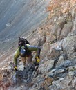
On top of North Carbonate, the weather was clearly building, so my stay on the summit was short. The register was placed in 1995 and was about 3/4 full. My hike back to the car was a little less pleasant that the first part of my day, the decent was down the north side of North Carbonate which is fairly loose and steep, making for a slow decent. Fortunately, the views from the valley were tremendous! Mt Princeton, tomorrows project! North Carbonate
My "home" (yea for car camping!) never looked so appealing after a long tiresome day!
After a beer, I headed down the road and found the Grouse Canyon trail head. The "trail head" for the South West route on Princeton is more or less a mile of 4wd road with a small clearing to park. The trail is marked with a big fallen log across the road and a few cairns; this route is off the beaten path for sure!
Day three started at 3:30 with granola and other dry foods. I'm a zombie at this point. The first mile was once again a snails pace, however, I quickly woke up and started moving. The only problem with this route is there is no route after about a mile after the trail head. No trail, no cairns, nothing. In the pitch black of a moonless night, I got off route from Roaches description and strayed to far from the stream; this became a miserable, bush whacking steep slog in the dark. crap. At this point, I decided that all mountains go up, so, I went up. It was steep. The sun rose, and I was still in the trees and it was steep.
I finally made the crest of the ridge and was rewarded with my first glimpse of Princeton's summit.
Overall, the route is definitely class 2/2+, however, getting around a large tower in the ridge proved to be a little closer to class 3, but very easy to tackle.
After summiting UR 13971, the summit of Princeton was easily with in grasp! The views from the top were spectacular, so great, in fact, that my camera batteries died! Oops, spare batteries in the car.
At this point, the weather was getting a little unsettled, however the clouds were not rising into the atmosphere, so I decided to add a few more points to my hike. From UR 13971, I continued NW along a ridge, then headed West, leading me to the summit of UN 13626, known as "Avery" according to the summit log that had been there since 1992.
The remaining hike back to the car was perhaps the best hike I have ever had. There is NO trail in Grouse Canyon, one simply follows the stream to the trail head. Aside from three trail runners that I had met on the summit of Princeton, I did not see anybody the entire day. Truly one of the best routes on a mountain I have ever done, capping off a tremendous experience in the southern Swatch range!
Here are some other photos of the trip!
Thumbnails for uploaded photos (click to open slideshow):
Two of those photos make it look like you had been hiking on Mars. The trip sounds nice and you certainly had better weather than folks one week later.
Don‘t know how much the gully had, however, given that the 4X4 road up Baldwin Gultch was free of snow and drivable to 11,500, it‘s entirly possible that the conditions in Brown‘s lake gulley are much the same.
Hope this helps!
Connor
Caution: The information contained in this report may not be accurate and should not be the only resource used in preparation for your climb. Failure to have the necessary experience, physical conditioning, supplies or equipment can result in injury or death. 14ers.com and the author(s) of this report provide no warranties, either express or implied, that the information provided is accurate or reliable. By using the information provided, you agree to indemnify and hold harmless 14ers.com and the report author(s) with respect to any claims and demands against them, including any attorney fees and expenses. Please read the 14ers.com Safety and Disclaimer pages for more information.
Please respect private property: 14ers.com supports the rights of private landowners to determine how and by whom their land will be used. In Colorado, it is your responsibility to determine if land is private and to obtain the appropriate permission before entering the property.


")
")
")
")
")
")
")
")
")
")
")
")
")
")
")
")
")
")
")
")