Download Agreement, Release, and Acknowledgement of Risk:
You (the person requesting this file download) fully understand mountain climbing ("Activity") involves risks and dangers of serious bodily injury, including permanent disability, paralysis, and death ("Risks") and you fully accept and assume all such risks and all responsibility for losses, costs, and damages you incur as a result of your participation in this Activity.
You acknowledge that information in the file you have chosen to download may not be accurate and may contain errors. You agree to assume all risks when using this information and agree to release and discharge 14ers.com, 14ers Inc. and the author(s) of such information (collectively, the "Released Parties").
You hereby discharge the Released Parties from all damages, actions, claims and liabilities of any nature, specifically including, but not limited to, damages, actions, claims and liabilities arising from or related to the negligence of the Released Parties. You further agree to indemnify, hold harmless and defend 14ers.com, 14ers Inc. and each of the other Released Parties from and against any loss, damage, liability and expense, including costs and attorney fees, incurred by 14ers.com, 14ers Inc. or any of the other Released Parties as a result of you using information provided on the 14ers.com or 14ers Inc. websites.
You have read this agreement, fully understand its terms and intend it to be a complete and unconditional release of all liability to the greatest extent allowed by law and agree that if any portion of this agreement is held to be invalid the balance, notwithstanding, shall continue in full force and effect.
By clicking "OK" you agree to these terms. If you DO NOT agree, click "Cancel"...
Noticing a spring-like weather forecast for the weekend, I took a friend down to Lake City intent on topping out on Sunshine Peak and Redcloud Peak before skiing back down. After doing my research, it seemed like the most reasonable winter route is to start at the Mill Creek Campground, gain Sunshine‘s east ridge, take the ridge to the summit and ridgewalk 1.3 miles to Redcloud. This TR is designed to be helpful to others pursuing a similar adventure.
Although the campground is not open or plowed, a good size pullout is plowed at the entrance to the CG. It was here (~9,500 ft) that we slept in the car the night before the climb. We were hiking by 6 am. The route begins abruptly by ascending northward from the campground to gain Sunshine‘s east ridge. Depending on the exact line chosen up this ridge, you will have to contend with varying levels of scree, dirt, cliffs, trees shrubbery, and possibly some snow. On Jan. 31, 2009, there was very little snow on this south face.
Initial slopes to gain the east ridge (we did this in the dark and somehow avoided all the cliffs)
The route we chose gained the ridge around treeline (~12,000 feet), which meant we were scrambling/bushwhacking for 2,500 vertical feet. Although steep and not far in distance, this portion of the climb was deceptively demanding. This half of our daily elevation gain demanded at least 3/4 of our energy.
The scree
Once on the ridge, the snow became less spotty and the terrain flattened out enough that I could take my skis off my back and skin for the next 1,000 vertical or so. My partner was on snowshoes.
First views of Sunshine Peak after gaining the east ridge
The final 1,000 feet up Sunshine was too steep for skinning, but just right for kicking steps sans crampons. Gaining the east ridge took its tole on my partner, so he opted to leave Redcloud for another day and descend the route we came up.
Looking down Sunshine‘s east ridge from the summit
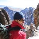
Redcloud Peak from the summit of Sunshine Peak
The San Juans to the north (Wetterhorn to Uncompagre)
Looking back at Sunshine from Redcloud‘s summit
From Sunshine‘s summit, it‘s a long 1.3 miles along the connecting ridge to the top of Redcloud. This traverse was quite brisk despite the beautiful weather that accompanied us. I skied from the top of Sunshine down to the first saddle, where I left my skis. After peak-bagging Redcloud, I returned to my skis and continued my descent from the saddle.
My ski descent started at the saddle just left of center. Skiers: note that there are some pretty splendid looking lines in this area when avy conditions are better.
The terrain in the upper part of this east facing basin is fairly steep (~35 degree max?) and not immune to avalanches. After selecting a relatively safe route, I skied down to treeline before skinning back up to gain the east ridge and meet back up with my partner. I wanted to continue skiing down the gully, thinking that I could avoid descending our miserable early morning ascent route by taking that gully all the way to Bent Creek, then following the creek back to the road. Having not actually tried this, I can‘t speak for it, but I‘m convinced that it would have been better than retracing our morning route, which we did.
I skied down the ridge until the combination of lack of snow and intensely tight tree spacing forced me to walk. About an hour and a half of unpleasant trudging later, we made it back to the car.
Altogether, the route took us about 10 hours. I think two fit skiers could reasonably do it in 7. I hope somebody finds this helpful!
Thumbnails for uploaded photos (click to open slideshow):
We were just there this past weekend 2/28/09, same conditions and wore ourselves out up that 4,000 ft gain in the beginning. Commendable that you went on to do Redcloud. 3 long months without much exercise will remind you how hard 14ers in the winter really are! VERY NICE!
My friend and I have been eyeing Sunshine and Redcloud as the snow it not too much further north. Also not much intel on this route on 14ers.
Caution: The information contained in this report may not be accurate and should not be the only resource used in preparation for your climb. Failure to have the necessary experience, physical conditioning, supplies or equipment can result in injury or death. 14ers.com and the author(s) of this report provide no warranties, either express or implied, that the information provided is accurate or reliable. By using the information provided, you agree to indemnify and hold harmless 14ers.com and the report author(s) with respect to any claims and demands against them, including any attorney fees and expenses. Please read the 14ers.com Safety and Disclaimer pages for more information.
Please respect private property: 14ers.com supports the rights of private landowners to determine how and by whom their land will be used. In Colorado, it is your responsibility to determine if land is private and to obtain the appropriate permission before entering the property.


")
")
")
")
")
")
")
")