Download Agreement, Release, and Acknowledgement of Risk:
You (the person requesting this file download) fully understand mountain climbing ("Activity") involves risks and dangers of serious bodily injury, including permanent disability, paralysis, and death ("Risks") and you fully accept and assume all such risks and all responsibility for losses, costs, and damages you incur as a result of your participation in this Activity.
You acknowledge that information in the file you have chosen to download may not be accurate and may contain errors. You agree to assume all risks when using this information and agree to release and discharge 14ers.com, 14ers Inc. and the author(s) of such information (collectively, the "Released Parties").
You hereby discharge the Released Parties from all damages, actions, claims and liabilities of any nature, specifically including, but not limited to, damages, actions, claims and liabilities arising from or related to the negligence of the Released Parties. You further agree to indemnify, hold harmless and defend 14ers.com, 14ers Inc. and each of the other Released Parties from and against any loss, damage, liability and expense, including costs and attorney fees, incurred by 14ers.com, 14ers Inc. or any of the other Released Parties as a result of you using information provided on the 14ers.com or 14ers Inc. websites.
You have read this agreement, fully understand its terms and intend it to be a complete and unconditional release of all liability to the greatest extent allowed by law and agree that if any portion of this agreement is held to be invalid the balance, notwithstanding, shall continue in full force and effect.
By clicking "OK" you agree to these terms. If you DO NOT agree, click "Cancel"...
Capitol - Avalanche Loop (with summits of K2 and Capitol)
Saturday: Capitol Creek TH to Daly Pass, Ridge Direct to K2, Northeast Ridge to Capitol, descend standard route, Capitol Lake to Avalanche-Silver Creek Trail (14 miles)
Sunday: Avalanche-Silver Creek Trail to Hell Roaring Trail to Capitol Creek TH (16 miles)
Friday: Are we ever going to get there?
Friday after work I took off from Fort Collins and fought the usual traffic on my way to pick up Heather in Boulder. On our way to Aspen we talked about our past weekends of climbing and if we were prepared for the notorious knife edge on Capitol. We thought the pictures made it look manageable, but the video on Bill's route description had both of us a bit anxious. We continued our climbing talk all the way to Aspen, arriving there around 9:30pm. Craig and Colin were already there and having their usual good times. Craig has been going on and on about his Capitol Project for a few months now, and this was his chance to actually do it. I won't go into too much detail about it other than it involved going straight from the bar and climbing Capitol. Colin's job was to make sure the first part of the deal was completed. Anyway, Heather and I find them at Bentley's with considerable damage already done. Boys... After a brief stint there, we wished Colin luck on finishing the 14ers with his dad the next day, and we were off. However, Craig decided we needed to stop by the Woody Creek Tavern to hear all about this Hunter S. Thompson guy that neither Heather nor I knew anything about. Unfortunately the tavern was closing shop as we got there, but at least we got to see the world's richest trailer park.
By now it's past 11pm and Heather and I are ready to get on up to the trailhead and out of the car. We decided to sleep for a couple hours at the trailhead and get an early start on Saturday. We finally made it to Capitol Creek Trailhead and laid our sleeping bags out on the ground for a few hours of sleep.
Saturday: Coyotes, Cows, and Cool Ridges
The alarm went off before we would have liked, but we were on the trail by 2:40am. Our first scare came within a couple minutes of the hike - coyotes off in the distance howling like it was Halloween. With three of us there it was ok, but I would not like to be doing this on my own! We followed the muddy trail for some time before coming to the creek crossing. Craig has been on this trail to Capitol a few times now, so finding the log bridge was not too hard.
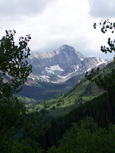
View of Capitol and K2 from a distance at night.
Soon after the crossing we receive our second scare... cows! If you ever come across large black cows in the middle of the night you'll know what we're talking about. They were looking at us with evil eyes of vengeance knowing that some day they may be on our dinner plates.
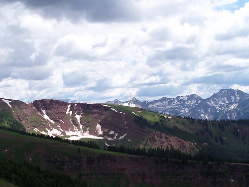
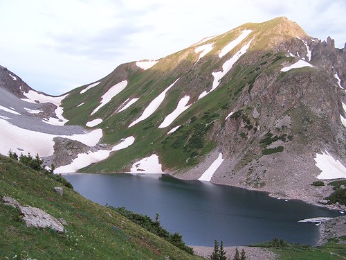
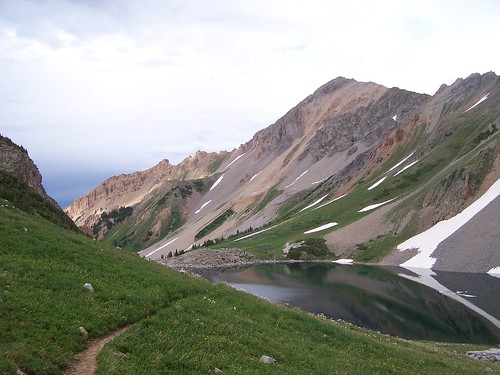
We made it to Capitol Lake just as daylight was making its mark. It was plenty overcast, but the clouds did not look threatening. We unloaded our big packs, got a quick bite, and started heading up to the saddle between Daly and Capitol. There were quite a few groups ahead of us, but they had the advantage of sleeping at the lake and getting an earlier start.
View northeast of Capitol Lake and Capitol Pass.
View north from saddle.
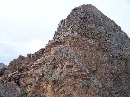
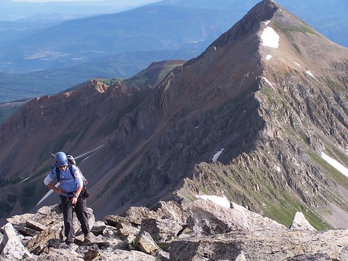
Up at the saddle we departed from the standard route and went for the direct ridge up to K2. Craig had gone this way a month prior, and Prakash (maverick_manley) said we would enjoy this route much more. We could see the other groups on the other side of the saddle traversing the snowfields and taking the standard way up. And although the way we went was shorter, it was very slow going; lots of class 3 and 4 moves with considerable exposure. We stayed high on the ridge and found solid rock with good handholds, but complete concentration was required. It wouldn't take much for a bad fall.
The first headwall.
Staying high along the ridge. K2 is on the left, Capitol is on the right.
Occasionally we would drop down a bit for easier climbing, but we would quickly regain the ridge and continue on. The ridge was long, and it seemed like it was going to take forever to get to K2 and Capitol.
Heather and Stephanie. (picture by Craig)
Craig along the ridge.
The ridge mellowed out the closer we got to K2, and it was a welcomed feeling to relax for a bit and take in the views.
Heather and Daly Peak.
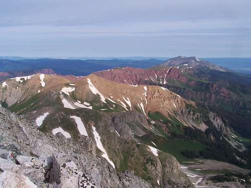
The colors in this region are magnificent!
We reach the base of K2 and decide it's worth the extra scrambling to the summit.
Heather topping out on K2.
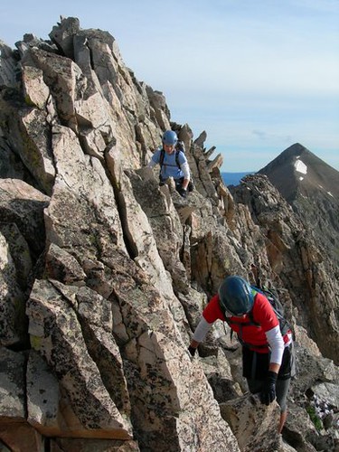
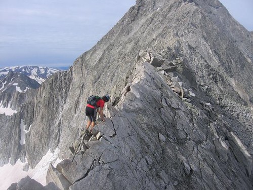
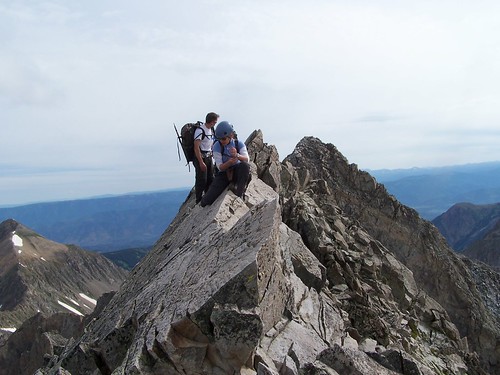
From here we could see the rest of our route to Capitol, including the knife edge. Down climbing K2 was no easy chore though. There are several ways to make this happen, but we went with the solid rock that was a bit more exposed. It wasn't long and we were at the knife edge.
Knife edge.
I went first and found it quite comparable to Meeker's knife edge, only longer. Heather and Craig followed right behind me and soon made it to the other side.
Stephanie along the knife edge. (picture by Heather)
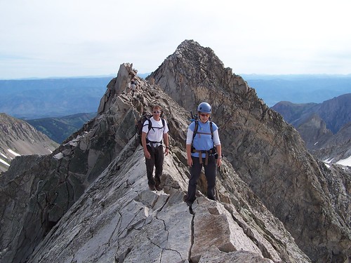
Heather and Craig on the knife edge.
As Prakash mentioned in his report, there are other mini-knife edges along the ridge, but they can be easily by-passed.
Heather along a mini-knife edge.
We continued along the standard path that drops below the ridge, and found the rock to be much looser. At this point most groups were making their way back down the mountain, and I'm sure they were thinking we were crazy to be continuing up this late with all the clouds in the sky. But the clouds didn't look threatening, plus it's a well-known fact that Heather scares away the thunderstorms. There were still a couple other guys up on the summit, but they left not long after we arrived.
Summit shot.
The daunting ridge to Snowmass.
We knew the hard part was only half over, so we started on down before the urge to nap on the summit took over. We followed the same path back to K2, but from there descended down the rock field to the snow. A few glissades, snow traverses, and some rock hopping later, we were back at the saddle. The hike back down to the lake went quickly as we were entertained by marmots, ptarmigans, and wildflowers. At the lake we cooked up some dinner, had some wine, and fell asleep.
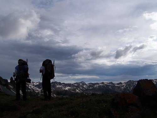
At 5pm we decided it was time to get going if we wanted to make it to Avalanche Creek for camp. There were a good number of groups coming in at this point, most of which were hoping to climb Capitol the next day. We followed the Capitol Creek Trail on up to Capitol Pass and had great views of Capitol's Slingshot couloir and the northwest route.
Capitol Lake and Daly Peak.
Heading up to Capitol Pass with the Slingshot Couloir on our left.
Heather and Craig at the pass.
From the pass we descended down about 3000' to Avalanche Creek. We considered adding a side trip to Avalanche Lake, which is said to have gorgeous views, but it was getting late and we needed to find a place to camp. We didn't see anyone along this trail, and the only signs of life were the hoof-prints in the muddy trail. We found a great place to camp just as it was getting dark enough for everything to start looking like a bear. It wasn't long before the tent was set up and we were asleep.
Sunday: Uphill, Bushwhacking, and F!@$%@$!!! Mosquitoes!
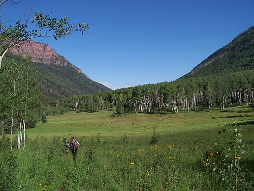
The alarm went off at 7am and an hour later we were on our way down the trail. The trail took us through dense forests, meadows, and along Avalanche Creek. We met a few trail runners along this section, and we also got a glimpse of a brown bear!
Duley Park.
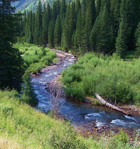
Avalanche Creek.
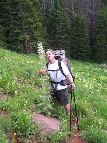
The trail continued downhill to about 8000', then it made a sharp turn away from Avalanche Creek and on up the hillside. At the Hell Roaring Creek bridge crossing we stopped for a few minutes to refill our water and have some food. The next section was going to be a brutal uphill battle of 4000' gain in 4 miles. A couple hundred yards past the creek crossing we reach the trail junction to Hell Roaring Trail. Just as we start up this trail we see another guy coming down. I jokingly ask if we are near the top and he just starts laughing in a "do you realize what you're going to be putting yourself through" tone. Indeed, the trail got steep really quick and it did not let up. And to make things worse, the trail was very overgrown with scrub oak and weeds. We could hear Hell Roaring Creek just off to our right and we read about all the cascading waterfalls along this route, but it was too overgrown to see much. And I was a little disappointed that I could not find my perfect waterfall to stand under. Oh well. We reached a couple of rock out-croppings and some meadows, which were in full bloom of flowers. Craig was excited to see the Monument Plant, one that flowers only once its lifetime of 20 to 80 years, and then dies.
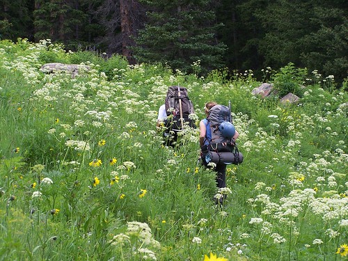
Craig and Heather surrounded by Queen Anne's Lace.
Craig and the Monument Plant.
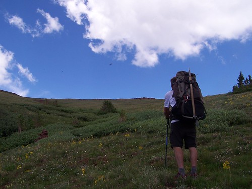
As we climbed higher in elevation, the trees became thinner and our views got better. We reached a small basin at 11,300', but instead of heading up this basin we followed the sporadic cairns that angled us up a steep hillside.
Basin at 11,300'.
It was around here that the mosquitoes came out in full force. Not even the slathering of jungle juice with 98% deet was enough to deter them. We kept trying to convince them there was better food to prey upon down by Capitol Lake, but it was no use.
Here is a blurry picture of a mosquito (the small black dot in the center), but somehow Craig and the wildflowers got in the way of my picture.
>
The creek valley that we came up.
View to the southwest.
The trail finally started to ease up as we neared the pass. Unfortunately the mosquitoes did not, and most of our energy was spent swatting at them. Once on the pass we took a few minutes to enjoy the last 4 hours of uphill labor, but our stay wasn't long due to these pesky little bugs.
View to the southeast from the pass.
Descending from the pass didn't take very long, and pretty soon we were back down below treeline. We had the option of visiting Williams Lake and Hardscrabble Lake, but the mosquitoes were just too bad, and Heather and I had a long drive ahead of us still. We followed the trail all the way to the Hell Roaring Trailhead, and here we had great views of Capitol Peak from a bit further out.
Capitol Peak from Hell Roaring TH.
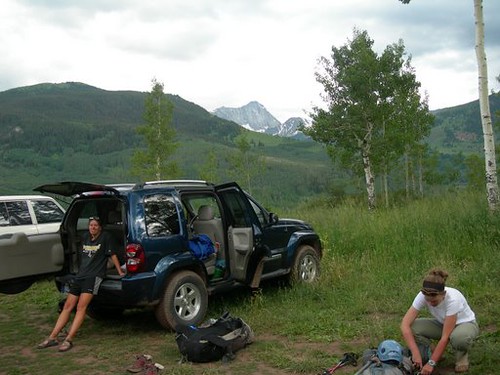
From this trailhead we took the dirt road back down to the Capitol Creek TH, and seeing my Jeep was a welcomed sight after a long day!
Finally back! (picture by Craig)
On our way out Heather and I got the low-down from Craig on the all the types of people that live along this valley: ranchers, Aspen yuppies, hippies, Buddhist monks, and John Denver's wife (so the rumor goes). We got some food at the Glenwood Brewery, and then Heather and I were back on the road for the long drive home.
This was definitely one of my favorite routes up a 14er. The long and exposed ridge from the saddle to Capitol's summit was both physically and mentally demanding, but there was never a time when I thought "Oh ****, I'm going to die" like I have for a couple other climbs I've done. It takes good route finding and careful hand and foot placement, but otherwise it wasn't too bad. The rest of the hike out was also enjoyable. It's not quite as scenic as the Four Pass Loop and the trail is a bit rougher, but it does offer a different perspective of the Elks and if you want solitude then this would be a great option.
Awesome report. But I have to say, technically you saw a black bear that happened to be brown in color. Brown bears are synonymous with grizzly bears, and I doubt there are any in CO.
with del_sur. I should have expected something like that coming from you, but I actually lolrotflmaohaha‘d out loud. Wait, did that just make me retarded? I take it back.
With the exception of the big yellow cow eyes staring at us, the first pic sums up the hike in! Great climbing/hiking with you both again! Sorry I couldn‘t scare away those damn mosquitos as well. 5 stars
Gerry Roach will be spitting up his tea when he reads this TR!
Surfer girls are in the mountains!
Stephanie was pretty modest about the glamour/hero pictures in this report. For all the fans of Stephanie and Heather that want more, check these out!
And I can‘t believe how good I look with the monument plant after what they put me through the previous day! I really should have been laid up in a tent at that point in the trip.
By the way, I think I will take at least 3 or 4 days to do this loop next time. And that was a cinammon bear, not a brown bear!
I'm pretty sure it must have been you three I saw on my way down from the summit. You all seemed pretty tired. Now, I know why. I remember Craig mentioning going down to Avalanche Lake. I never did see you come down back to Capitol Lake so I thought you might have gone down a different route. I guess I just missed you as we were most definitely just relaxing around camp.
P.S. I think you needed a little longer shutter speed on that first pic.
I‘ve never seen Capitol so clearly in the dark.
Bears, cows, mosquitos... I can‘t believe you made it home in one piece.
Very nice report, photos, and climb. Thanks for the fresh perspective on parts of the Elks I sure haven‘t seen.
Bobo, that did come up in our discussion of what type of bear it really was. Although we only saw it for a brief moment, it was definitely brown in color. We weren‘t sure if black bears got that light in color, and we also thought that brown bears were smaller and less agressive than grizzlies. I didn‘t realize they were actually the same. Thanks for clearing that up for us, I learn something new everyday!
del_sure, I took me FOREVER to get that one picture to come out right! Glad you found the humor in it!
Presto, thanks! The three of us all agreed it was a really cool route. You seem to do a lot of non-standard routes and trips as well, so I‘m sure you can relate.
Valerie, sorry to hear you couldn‘t join us. It would have been great to meet you and would have been quite a fun group. We‘ll have to go for a climb sometime soon though!
Sunscreen, were you the group with rum? We saw some people just as we were coming down the pass, I wonder if that was you. It looked like you had a pretty sweet place to chill. We hung out a 100 feet or so from that 3-way trail junction for a couple hours before taking off again.
Heather and Craig, as always, how can I not have a good time with you both?! You guys rock.
Congrats to you and your friends, Steph! Nice photos. Way to get 'er done (and not with the standard return route)!
Caution: The information contained in this report may not be accurate and should not be the only resource used in preparation for your climb. Failure to have the necessary experience, physical conditioning, supplies or equipment can result in injury or death. 14ers.com and the author(s) of this report provide no warranties, either express or implied, that the information provided is accurate or reliable. By using the information provided, you agree to indemnify and hold harmless 14ers.com and the report author(s) with respect to any claims and demands against them, including any attorney fees and expenses. Please read the 14ers.com Safety and Disclaimer pages for more information.
Please respect private property: 14ers.com supports the rights of private landowners to determine how and by whom their land will be used. In Colorado, it is your responsibility to determine if land is private and to obtain the appropriate permission before entering the property.


 >
>