Download Agreement, Release, and Acknowledgement of Risk:
You (the person requesting this file download) fully understand mountain climbing ("Activity") involves risks and dangers of serious bodily injury, including permanent disability, paralysis, and death ("Risks") and you fully accept and assume all such risks and all responsibility for losses, costs, and damages you incur as a result of your participation in this Activity.
You acknowledge that information in the file you have chosen to download may not be accurate and may contain errors. You agree to assume all risks when using this information and agree to release and discharge 14ers.com, 14ers Inc. and the author(s) of such information (collectively, the "Released Parties").
You hereby discharge the Released Parties from all damages, actions, claims and liabilities of any nature, specifically including, but not limited to, damages, actions, claims and liabilities arising from or related to the negligence of the Released Parties. You further agree to indemnify, hold harmless and defend 14ers.com, 14ers Inc. and each of the other Released Parties from and against any loss, damage, liability and expense, including costs and attorney fees, incurred by 14ers.com, 14ers Inc. or any of the other Released Parties as a result of you using information provided on the 14ers.com or 14ers Inc. websites.
You have read this agreement, fully understand its terms and intend it to be a complete and unconditional release of all liability to the greatest extent allowed by law and agree that if any portion of this agreement is held to be invalid the balance, notwithstanding, shall continue in full force and effect.
By clicking "OK" you agree to these terms. If you DO NOT agree, click "Cancel"...
Distance: 31 miles (w/ winter route adjustments)
Elevation Gain: 7225' (including 1150' on return)
Trailhead: Tigiwon snow closure 7980'
Time: 3 days Summit day: 10 hours
For two weeks I'd been debating whether to use President's day weekend to tackle Handies or Holy Cross. My plans for both necessitated a three day weekend. Posts on 14ers.com and 14erworld.com had both failed to scare up a partner for either peak. I decided to wait until the last minute on Friday afternoon to make my final decision. By that time the weather on Handies was predicted to be quite nice, but the avalanche conditions were rated considerable to extreme depending on the slope. The Holy Cross forecast called for mostly cloudy skies with blustery winds, but the avalanche conditions were evaluated at moderate (with pockets of considerable on aspects that I did not anticipate traveling). Avalanche conditions trumped weather; I'd attempt Holy Cross.
A note from Jason Halladay informed me that I'd be able to drive to the trailhead in my Toyota Corolla; the 4WD Jimmy would not get me any closer. I decided to apply the gasoline savings as partial payment for a Leadville motel. I must be getting older. Until this year, I always spent the night before a climb sleeping in the back of the Jimmy; this winter virtually every climb has been preceded by a nice rest in a warm motel. Cooper (my dog) and I enjoyed a restful evening at the pet friendly Timberline motel in Leadville.
Saturday morning we woke at 5AM, dressed in cozy clothing, had Ramen noodles and two quarts of Gatorade for breakfast then drove the last 25 miles to the winter Tigiwon Road trailhead � mile off Hwy 24 just north of Minturn. The winter trailhead is at 7980'. In the summer, you can drive 8 � miles up this road to the high clearance 2WD trailhead at Half-moon campground. Winter, of course changes things. I'd need to walk the 8 � miles and 2620' to the campground before the real work would begin. I'd heard that this road was packed by snowmobiles, but that is an understatement. Nova guides of Minturn use a ski-area style groomer to make a beautiful 20' wide track all the way to the campground. I didn't even don snowshoes; I just walked right up. We trudged off at 7AM.
Cooper loved it; he could run, jump, play in the snow and never had to drag his belly through the cold stuff. It's as much fun as he has had below timberline all winter.
What's that snow bulge?
It‘s a roof! About 5 miles up the road is the Tigiwon Community House.
It is USFS facility which can be reserved for group use. Nova guides has an ongoing contract to use the building as a warming hut for their clients. When I stopped in, there was nobody home; I figured nobody would care if I filled my thermos with some boiling water and a little spiced cider. YUM!
The Gore Range view from the veranda.
After refreshments and a bathroom break I marched on. There are several places where more adventuresome snowmobilers took routes which bypassed switchbacks in the road. With the packed route, I was able to take advantage of the same shortcuts.
At mile 6 �, I was greeted with my first views of Notch Mountain, the elusive Holy Cross still in hiding.
I reached the summer trailhead end of the groomed road at 10:15 AM. Activate your beacon before entering the outhouse.
Now the work got tough. The Half-moon trail is supposed to climb 1360' in 1� miles to Half-moon pass, timberline at the NE corner of Notch Mountain. There was no broken trail in this area. I started up at 10:30. I didn't like the way the contours showed the final portion of the trail reaching the pass in a large open area with eastern exposure. I decided to take a direct route on fairly consolidated snow through the trees and hit the ridge about 100' above and 1/8 mile north of the true Half-moon pass. I could then use the safer north ridge to descend to the pass. I missed by about 1/8 mile more and gained about another 100' more than I expected, 1500' total. To this point, the weather had been ideal, much better than forecast. The skies were clear but the winds (now that I'd reached the ridge) about 15-20 mph.
At the pass, I was greeted with my first grand views of Holy Cross. Wow!
I reached the pass about 12:30 and set a camp in a group of trees on the pass. I stuck my rear end to the increasing westerly winds and built walls on every side high enough to protect my camp.
By the time I finished camp it was 2PM and the weather had taken a real turn.
As mentored by Ken Nolan and Jean Aschenbrenner, I decided to use the remaining daylight to do some reconnaissance work for tomorrow's summit attempt. Cooper would stay in the tent to rest.
The first task was to traverse � mile from the pass at the NE corner of Notch Mountain to the SW corner of the same mountain. This was the first part of the trip that was concerning. The traverse crossed under the north slopes of Notch mountain which appeared to normally be windblown, but today had some loading fed by Friday's 12" storm and today's incessant 15-20 mph winds. I worked to abate the issue by dropping a bit below the pass and following the edge of timberline west to the NW ridge. By Sunday morning, these efforts had been completely blown away by the night's winds.
The next step was to drop down to Cross Creek. In the summer a very steep trail switchbacks 1000' down through cliffs on the west face of Notch mountain to reach nice, but scarce, creek-side campsites. That route would be dangerous in winter. As recommended by Lou Dawson, from the NW corner of Notch Mountain, I left the summer route to drop about 300' along a NW ridge before following a subsidiary WNW ridge to the bottom of the creek. This route drops you about 150' lower than the summer route. Don't kid yourself; this is still a very steep route. You can follow treed and bouldered areas to the creek bottom, but be careful. Breaking trail to Cross Creek was my goal for the day. It took me about 1 � hours to get down there from camp. I had no idea that the trip back to the tent would be so gruesome. Snow that supported me on the descent turned to hip-deep sugar snow on the ascent. I was still going from tree to tree and rock to rock on what was basically a rib, but the effort was enormous. It took a full two hours to reach camp at 6PM.
Returning home to Cooper I found that spindrift had breached my fortification and 3" of snow had to be dug out around the tent. 1 � hours were needed to melt 3 quarts of water, one brought to a full boil for my re-hydrated stew. I had cell phone service and called my kids to see how their day went skiing at Crested Butte and then snuggled into bed. The temperature dropped to zero and the winds increased to 30 mph, but the snow walls held and the tent didn't even quiver in the wind. The spindrift problem persisted, however, and by morning I had a foot of snow all around the tent (though only about 2" of new snow actually fell). All the negative aspects of a single-walled Bibler tent were evident; the insides of the walls were heavily frosted and whenever I bumped the side of the tent while turning over, a shower of interior snow fell over my face and sleeping bag. It was so wet that Cooper drank by licking the tent walls. In spite of this inconvenience, I was quite comfortable and slept well.
At my 5:30AM anticipated blast-off, the winds were about 40 mph. No go. At 6:30AM and 7:30AM, the story was the same. Finally, at 8:30AM, I decided to give it a go. Cooper voted to stay home. He may be a dog, but he's brighter than some president's we have (I mean had).Once out of the tent, I could see as much of Holy Cross and its route as I could from inside.
I could at least break trail to timberline on Holy Cross's north ridge and give it another go Monday (though my boss and ex had been told of this possibility, neither would be too happy with me). Crossing again under Notch Mountain's north face, I hugged the trees and wished my obliterated trail would magically reappear. As soon as I was out of the vortex of the pass proper, wind speed dropped to something closer to 15-20mph. Once I was using yesterday's trench to drop into Cross Creek, Saturday's work paid dividends and the frozen snow took me down to the creek like a set of stairs.
Now, on un-broken snow, I began at 9:40AM to re-climb the lost 1150' to breach timberline on Holy Cross's north ridge. It is not an exaggeration to say I was climbing blind. I could see none of the route and was navigating by memory and map. The thinker was thunking good today; at 11:30AM, I broke out of the trees exactly where I had planned. I was 2400' and � mile below the summit. In bearable wind with spindrift aplenty, I pushed on to an unseen goal. For about 5 minutes around the noon-hour, I saw my shadow!
Yes Virginia, there is a Colorado 14er initiative
Brief views of Notch Mountain and a 13,400' bump on my ascent ridge helped me orient myself. Lack of a visible goal, solo travel, and thinking about the 1150' climb that would accompany any end to my day taxed me mentally. At several times I thought I'd call it quits. But every time I checked the altitude, I saw decent progress; I was now making 1200' per hour.
At 13,400' there is a long stretch of flat ground before you climb the last 600' of the summit pyramid.
I stashed the snowshoes here and clambered off to the top.
The view down the ridge of the summit pyramid to the snowshoe stash and the flat area beyond
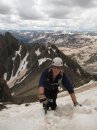
I arrived on top at 1:30. Notch Mountain peeked out, but disappeared before I armed the camera.
My hero shot from (of!) the summit. Impressive payoff for all that work.
I had originally planned "The Sign of the Cross" (I just made that up. No offense to my fellow Vatican devotees). I intended to circle back to camp via the Halo ridge route; however, the weather put me off spending that much time above timberline. I had given up the idea when I stowed the snowshoes. As I descended and retrieved snowshoes, the goggles finally gave out and frosted over. Lifting them a bit and pulling my face-mask higher, I was able to create a viewing slit. It took the same time to reach the trees as it had from timberline to the summit.
I still had to consider the drop into the creek and the ascent up the other side. The summer route is through the cliffs on the left side of the photo; my route is up the slopes on the right side.
Once here, however, the tromp to Cross Creek was quick and pleasant, reaching the low point at 4:30PM where I was met by a mysterious mustachioed man.
Colonel Mustard in the Ballroom with the lead pipe.
The hour I'd made up on the descent was lost on the ascent back to camp. The snow had remained frozen and, though I occasionally used a tree branch to pull myself up, the climb to Notch Mountain's NW ridge went much easier (though, due to fatigue, no faster) than yesterday.
That mountain doesn't look so hard!
I was home by 6:15PM. The day had been just short of 10 hours. Cooper met me in his French maid outfit, but he was rebuffed. Another foot of spindrift was dug from around the tent. Too tired to do otherwise, I ate a cold dinner, melted a single quart of water for the trip out and finished the cider pilfered at the Tigiwon community house. I called the Kids to say good night and cuddled up with my special teddy. Though the top of the down bag was still wet and got wetter as the night went on, I slept well and woke about 6AM to pack for the trip out.
At 7:30AM, I was pointing downhill and assumed a more direct route than Saturday to reach the groomed road at Half-moon campground (though I still avoided the open area just east of the pass). By 9AM, I had reached the road and just before a 10AM arrival at Tigiwon Community House, I saw my first snowmobiles. The cabin, however, was deserted again. More spiced cider supplemented my single quart of water. I tipped the guide service (I left them a note saying they should lock up their cider) and closed the door when we left. Cooper and I waved "Hello" to a dozen or so snowmobilers as we marched the final miles to the car. We returned about 11:30AM. Of course, today's weather was similar to Saturday's, clear but windy. Only summit day was obscured.
Here is a final view of Notch Mountain taken from higher up on Hwy 24. The Half-moon campsite is visible in the small patch of trees in the saddle at the far right-hand side of the mountain.
Minturn's version of a $1,000,000 home
A fun weekend yielded an appreciated peak.
Thumbnails for uploaded photos (click to open slideshow):
According to his 14erworld climbers corner, Steve has done 40 ranked 14ers in winter with a total of 91 ranked ascents. Amazing solo effort, Steve! I like your beacon outhouse shot. I would be afraid the whole structure would collapse!
You have a great writing style, Steve (and I love your dog‘s name, Cooper ... that was our first cat‘s name). Enjoy reading your trip reports and the pix are wonderful. Sounds like it was a great winter trip! Thanks for posting. Happy trails!
Very impressive expedition. Tough peak anytime of year, but adding all that distance from the road closure and breaking trail solo, well you can be proud of that. I have a special attraction to this peak as it was the first 14er I attempted after moving to Colorado and it is the monarch of Eagle County (my home the first three years here). Few get to climb it in winter, congratulations!
Bill said ” Thanks for the info about sledding up to the end of the road”. I should have mentioned that 1/4 mile off the highway, you‘ll find a locked gate with a sign which reads ”Gate opens at 7am and is locked promptly at 5:30 PM”. As I was unloading at 6:30 AM, a NOVA employee pulled up and unlocked the gate. He explained that I could drive in another 1/4 mile and park in a lot up by their sheds/office/snowmobile storage. I said I did not know when I‘d be coming out and, therefore, opted to stay in the smaller parking area on the unlocked side of the gate. He said they don‘t actually lock up until about 6PM. Still, I didn‘t want my opportunity to leave to be dictated by the special use permit of a tour company. The guides were very nice, greeting me cordially both on my way in and my way out. But this still seems a screwy way to handle winter parking at the trailhead(s).
Wow, Steve! Holy Cross in winter...that‘s bragging rights in my book. I find it extremely interesting that the road was groomed to the summer TH. That‘s something that I hadn‘t expected. I didn‘t know NOVA used the warming house in winter. Having a packed road must have been a HUGE relief!
Good job of negoiating the west side of Halfmoon Pass. That side must have left you with some consternation as to how to get safely down. I feel for ya having to do that on the way back out.
I also enjoyed reading this and the sprinkled bits of humor!
The president crack had me coughing (attempting to laugh) for a few minutes!
Magnificent job!
Caution: The information contained in this report may not be accurate and should not be the only resource used in preparation for your climb. Failure to have the necessary experience, physical conditioning, supplies or equipment can result in injury or death. 14ers.com and the author(s) of this report provide no warranties, either express or implied, that the information provided is accurate or reliable. By using the information provided, you agree to indemnify and hold harmless 14ers.com and the report author(s) with respect to any claims and demands against them, including any attorney fees and expenses. Please read the 14ers.com Safety and Disclaimer pages for more information.
Please respect private property: 14ers.com supports the rights of private landowners to determine how and by whom their land will be used. In Colorado, it is your responsibility to determine if land is private and to obtain the appropriate permission before entering the property.