Download Agreement, Release, and Acknowledgement of Risk:
You (the person requesting this file download) fully understand mountain climbing ("Activity") involves risks and dangers of serious bodily injury, including permanent disability, paralysis, and death ("Risks") and you fully accept and assume all such risks and all responsibility for losses, costs, and damages you incur as a result of your participation in this Activity.
You acknowledge that information in the file you have chosen to download may not be accurate and may contain errors. You agree to assume all risks when using this information and agree to release and discharge 14ers.com, 14ers Inc. and the author(s) of such information (collectively, the "Released Parties").
You hereby discharge the Released Parties from all damages, actions, claims and liabilities of any nature, specifically including, but not limited to, damages, actions, claims and liabilities arising from or related to the negligence of the Released Parties. You further agree to indemnify, hold harmless and defend 14ers.com, 14ers Inc. and each of the other Released Parties from and against any loss, damage, liability and expense, including costs and attorney fees, incurred by 14ers.com, 14ers Inc. or any of the other Released Parties as a result of you using information provided on the 14ers.com or 14ers Inc. websites.
You have read this agreement, fully understand its terms and intend it to be a complete and unconditional release of all liability to the greatest extent allowed by law and agree that if any portion of this agreement is held to be invalid the balance, notwithstanding, shall continue in full force and effect.
By clicking "OK" you agree to these terms. If you DO NOT agree, click "Cancel"...
Sorry for the late post, I originally posted this elsewhere but wanted to make it available on this site for those who are interested. I climbed this peak on July 1, 2007.
After successful climbs of Dallas on Friday and Vermillion, Golden Horn, and Fuller on Saturday, we were on for the Teakettle. Chris Orwat and I camped at about 10,600 just off the road to Yankee Boy Basin. We drove in after dark the previous night and were able to find a decent spot. The road is in great shape up to 10,700, 2-wheel drive vehicles can make it there. We drove higher on a much rougher road to the parking area at 11,300 ft. There is no camping allowed above the 2-wheel drive trailhead.
We started up about 7:45 a.m. Sunday morning. If you are doing Teakettle, it is best to park in the area about 100 yards below the outhouse. The route heads up grassy slopes from there. We made good time on the grass as the views opened up behind us. Our first goal was the base of Coffeepot at 13,440 ft. The grass ends at 12,400 ft. There is no trail really, just up and away. The rest of the route up to the ridge is just as nasty and loose as I'd read about in other trip reports. Expect your feet to move in an unanticipated direction on almost every step. The footing gets better the last 200 vertical feet beneath the Coffeepot.
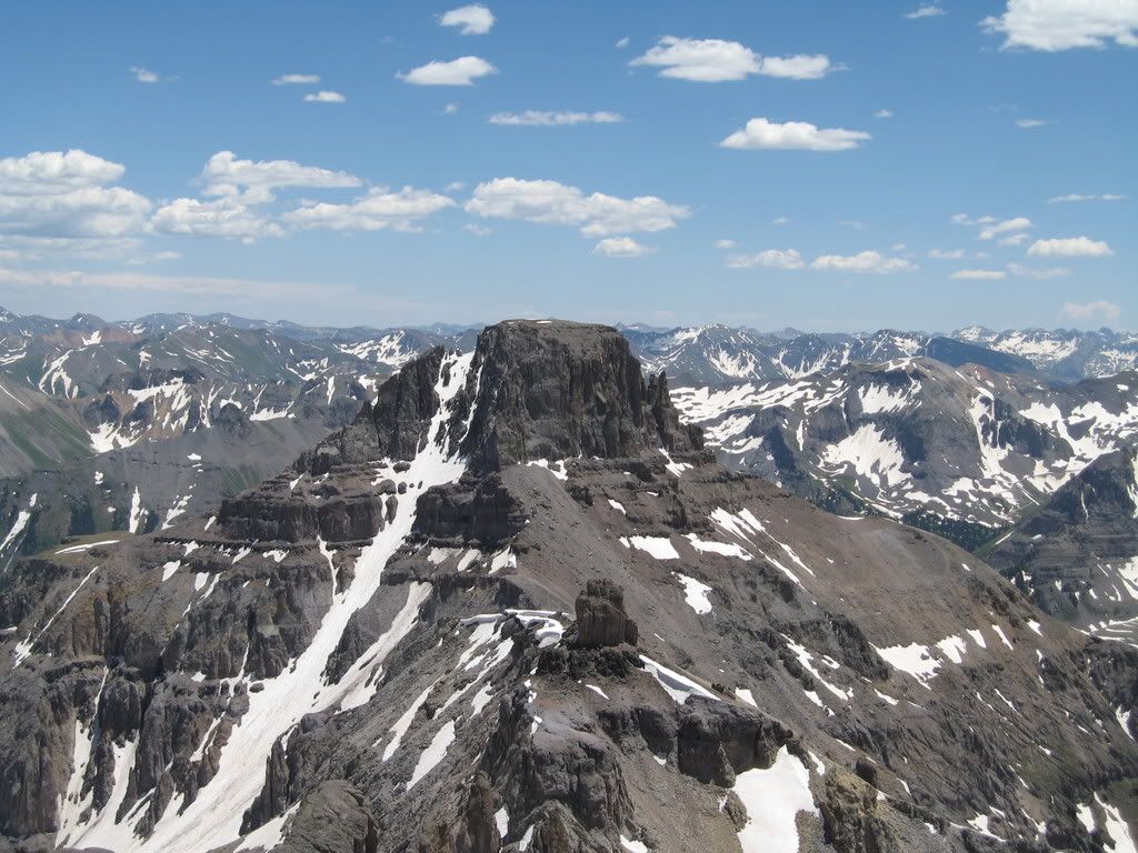
We were at the Coffeepot by 10:00 a.m. where great views open to all sides. We studied Potosi for a possible afternoon attempt. It looked pretty imposing. Chris was up there first and was a bit distraught looking over at our next objective, the black gully. The gully was only partially black, mixed in with a fair amount of snow and ice for a salt and pepper look. Unfortunately our crampons were in the 4-Runner (decided to leave them behind after not needing them the prior two days). We had not anticipated ice in the gully at all, a mistake on our part. We nearly bailed out back to Potosi but I talked Chris into heading over for a closer inspection.
View of Potosi from Coffeepot:
The next section was around a snow bank and down about 200 vertical feet in a nasty gully. Just as we headed out, a huge natural rockslide headed down the northern ramparts of Teakettle in two events separated by a minute. These were car-sized blocks and it sounded like a plane was overhead. It was the most amazing thing and the biggest rock slide either of us had ever seen. We were glad that this was not our route; helmets would have been little use in that situation. Once down the gulley we traversed towards the black gulley. I got there first and analyzed the situation. It didn't look as bad up close, but there was definitely a dicey section or two. We decided to rope up and protect the route. I led the first pitch and got a cam into a crack on the right side of the gulley. I then headed up and across the snow and ice to the other side. Without crampons I had to chop steps along the way, it was still frozen hard and shaded. Upon reaching the left side I put another piece in and headed up to a belay anchor. We only had an 88ft rope and I ran it out to the end. This was my first mixed ice/rock lead but I enjoyed it. It was comforting to have the safety of the rope there. I brought Chris up and he lead the next pitch on mainly rock to the top of the gulley. We were safe and back on track, though it cost us an extra hour there.
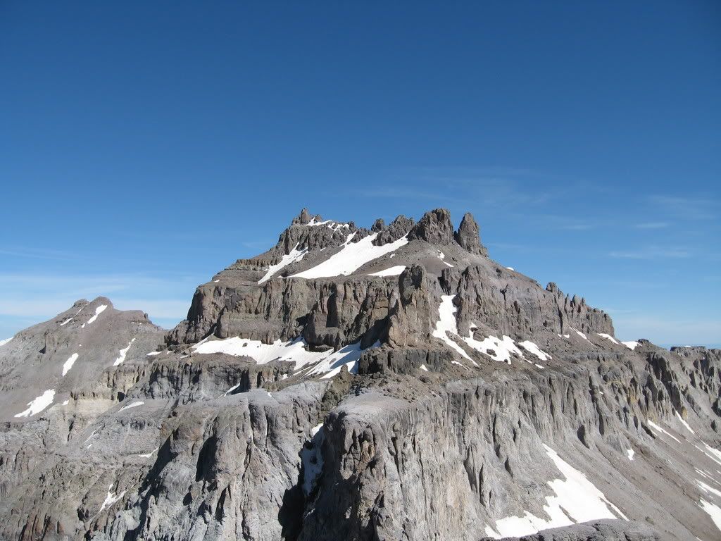
Teakettle Upper Mountain:
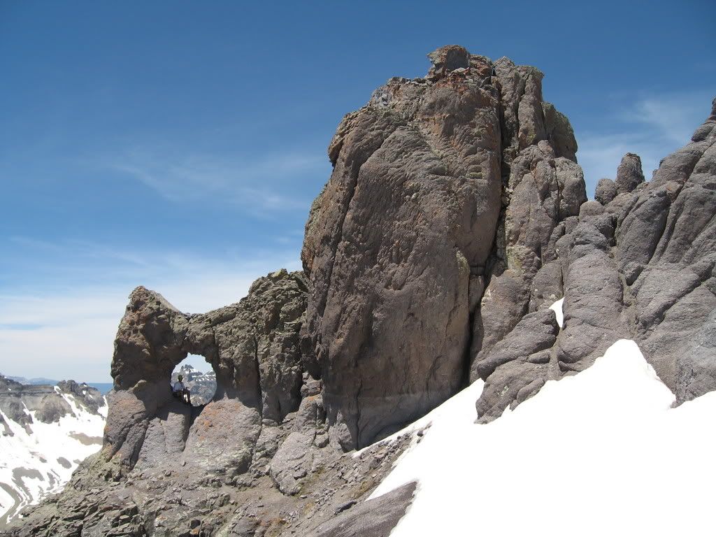
From the gulley the route traverses the mountain and heads up two sandy scree gulleys. We had to avoid a few big snowfields and crossed over one gingerly. The first big gulley was snow-free, and the second one had some snow. As we got closer to the summit tower I was elated and knew our chance of success was almost certain now. We reached the handle of the Teakettle and took turns getting pictures there. The handle was completely awesome. We then headed up 20 ft of steep snow to the base of the summit pitch. Though we had seen footprints earlier in the climb we never did see them up here. This led me to believe that we were probably one of the first parties up the Teakettle this year. We roped up again as I cleared the belay station of snow and ice. Chris had brought rock shoes and led the pitch. He decided to head straight up and avoid the chimney for a more aesthetic line. He put in two pieces and headed up the crux, and just like that he was on the summit. My turn. I only had my hiking boots so I removed the pro as he belayed me up the chimney. This was fun climbing, but I was glad to have the protection of a rope.
The summit tower with me in the handle:
We topped out at about 1:30 p.m. It was quite a relief after all the different challenges we had faced. The summit was very tiny and we stayed clipped into the rappel anchors for safety while we ate lunch and took pictures. Chris tried to call his wife but there was no signal. The weather was clear and warm with little wind.
The descent was fast! We rapped off the summit tower and reached the black gulley again quickly. By now it had softened and we carefully downclimbed it with no rope. There was a lot of water running though it. Without our ice axes it would not have been feasible to cross safely. We had to slam the pick into the ice as we traversed the steps we had cut earlier. Back up to the Coffeepot, where we decided to leave Potosi for another trip in the interest of a meal and getting back to Denver. We surfed down the loose rock and scree section; this was a lot more fun then it had been coming up. We also found a couple of snow gullies where we glissaded several hundred feet to about 12,000 ft and back on grass. We reached the car at 4:30 p.m., just over two hours since leaving the summit.
I loved this climbed for all of its challenges. It was my 98th summit of the 100 highest in Colorado and was well deserving of the honor. It was the capstone to a fabulous weekend in the San Juans. We toasted the weekend later over beer and food at Buen Tiempo in Ouray. If you like Mexican food at all, you have to try this place. It was better than most places I've gone to in the metro area and well worth a visit.
Long live the Teakettle, a very special place in the heart of the Colorado San Juans!
i was up there on Sunday Aug 12. There was no snow anywhere on the route (Teakettle/Coffeepot/Potosi). Leave the snow tools behind, and have fun!
-Scott
Steve! That is an unbelieveably KILLER shot of Potosi and the summit tower on Teakettle! You've REALLY got my mouth watering now. Like Jamie said, it's gonna be a long 3 weeks now!
I think I'll bring along some snow tools, just in case.
In the picture of Teakettle, once topped out on the Black Gully, did you & Chris traverse to the left or right?
Dude! Congratulations on your 98th centennial! That's bragging rights! What 2 lone peaks are left?
You'll definitely like this climb (once you reach the 13,000 ft ridge at least). Who's going to lead the summit pitch?
From the top of the black gully you traverse to your left, looking for the proper gully to ascend upward. Roach's route description works pretty well. You probably won't have much snow left then, if any.
Thanks for the congrats on 98. I have Gladstone and Jagged left. I hope to climb Gladstone Labor Day weekend and make it 99. Then I'll have Jagged to dream about all winter!
Thanks for posting the report, Steve. It will make the next 3 weeks seem even longer! Spectacular pictures!I had never seen a close-up of the handle before. 8)
Caution: The information contained in this report may not be accurate and should not be the only resource used in preparation for your climb. Failure to have the necessary experience, physical conditioning, supplies or equipment can result in injury or death. 14ers.com and the author(s) of this report provide no warranties, either express or implied, that the information provided is accurate or reliable. By using the information provided, you agree to indemnify and hold harmless 14ers.com and the report author(s) with respect to any claims and demands against them, including any attorney fees and expenses. Please read the 14ers.com Safety and Disclaimer pages for more information.
Please respect private property: 14ers.com supports the rights of private landowners to determine how and by whom their land will be used. In Colorado, it is your responsibility to determine if land is private and to obtain the appropriate permission before entering the property.