Download Agreement, Release, and Acknowledgement of Risk:
You (the person requesting this file download) fully understand mountain climbing ("Activity") involves risks and dangers of serious bodily injury, including permanent disability, paralysis, and death ("Risks") and you fully accept and assume all such risks and all responsibility for losses, costs, and damages you incur as a result of your participation in this Activity.
You acknowledge that information in the file you have chosen to download may not be accurate and may contain errors. You agree to assume all risks when using this information and agree to release and discharge 14ers.com, 14ers Inc. and the author(s) of such information (collectively, the "Released Parties").
You hereby discharge the Released Parties from all damages, actions, claims and liabilities of any nature, specifically including, but not limited to, damages, actions, claims and liabilities arising from or related to the negligence of the Released Parties. You further agree to indemnify, hold harmless and defend 14ers.com, 14ers Inc. and each of the other Released Parties from and against any loss, damage, liability and expense, including costs and attorney fees, incurred by 14ers.com, 14ers Inc. or any of the other Released Parties as a result of you using information provided on the 14ers.com or 14ers Inc. websites.
You have read this agreement, fully understand its terms and intend it to be a complete and unconditional release of all liability to the greatest extent allowed by law and agree that if any portion of this agreement is held to be invalid the balance, notwithstanding, shall continue in full force and effect.
By clicking "OK" you agree to these terms. If you DO NOT agree, click "Cancel"...
Date: Friday, March 9, 2007 Group: USAKeller and sdkeil Total mileage: 12.4 miles Total elevation gain: ~5,000ft. Route: Southeast Ridge from Harvard Lakes TH
This "trail" is a little over 6 miles long and attacks Mt. Columbia from it's southeast ridge. It's located about 1 mile shy of the North Cottonwood Creek TH on the north side of Chaffee County 365. We were able to drive up to within � mile of the Harvard Lakes TH- some soft snow kept us from going any farther. This road has a major rut in it and is rough in some areas. At the least, a Subaru Outback with chains and careful driving would make it to where we did with the current conditions.
Earlier this past summer, sdkeil and I climbed Mt. Harvard, however, the weather prevented us from traversing over to Columbia that day. So, we decided last-minute Thursday night to attempt Mt. Columbia yesterday and finish off the Collegiate Peaks. In addition to Blanca Peak last week, this would be a new peak for both of us. We arrived at the "camp site" around 11:15pm, parked just off the side of the road (N38deg 51m39.2s, W106deg 13m49.4s; elevation: 9,260ft.), and laid out sleeping bags in the back of my Durango. After a short, but decent night's sleep, we were on the road at 7:20am- snowshoes were not necessary (temperature: 33 deg.), and came to the Harvard Lakes/Colorado Trail turn-off (N38deg 51m52.2s, W106deg 14m,19.4s; elevation: 9,470ft.), which is relatively easy to spot. We hiked up the Colorado Trail (it has two switchbacks) while gaining good elevation. After the second switchback, we came to the Harvard Lakes-Colorado Trail junction (N38deg 52m6.9s, W106deg 14m24.2s; elevation: ~9,950ft.)- this is the foot of Columbia's southeast ridge. The Colorado Trail stays to the right; the Harvard Lakes trail heads up to the left. We had help from sdkeil's GPS (thank God for these devices )- he had drawn a track for which we would follow and pre-loaded it onto the GPS. We put on snowshoes here. Since this route is traveled infrequently, we never found much of a defined trail until on the way down where we spotted some trail segments. There are random cairns along the way, but don't appear to be all that helpful (simply stay on the ridge when in doubt). Below treeline, we came across patches of heavy snow mixed with areas of no snow while gaining a lot of elevation. It made the trek difficult given the steep and sometimes rocky terrain- should we take our snowshoes off and post-hole waist-deep, or should we just walk on the rocks with snowshoes on? We decided to leave the snowshoes on. We were able to see much of the approach to Horn Fork Basin, and noted a few avalanche slopes on the south (left) side of the valley (see photo below). Although they didn't seem to have recent activity, these slopes would be a concern to anyone traveling this standard route for Harvard and/or Columbia.
The north side of Mt. Yale- two main avalanche slopes can be seen on the left side of the photo (taken from 11,000ft.):
We stashed the snowshoes near treeline around 11,400ft. The weather was completely sunny and quite pleasant. We agreed that, up to treeline, this route was fairly steep. After this point, the ridge becomes a nice, gradual slope up to the summit.
A photo of the southeast ridge from 11,400ft. to near Point 13,298:
Along this gradual ridge, we contoured as many of the points along the ridge as possible to avoid having to gain and lose any extra elevation. We recommend to stay low along the south side of Point 12,740 and contour it in such a way that you will gain the saddle on the far side of it. There are faint sections of a climber's trail that we saw on the way down (of course), which were even lower than where we climbed up.
Looking back at our route from treeline, around Point 12,740, and up to 12,840ft.:
From about 13,250ft. to the summit, we stayed along the left (west) side of the ridge, where there was plenty of windblown talus to walk across. Around 13,500ft. on the ridge, we did some low class 2 work and skirted around the last major point on it's left side (marked on the photo below). After this point, the ridge appears to be quite snow-covered, but again, staying on the left side of it provides enough talus to easily avoid use of crampons and/or an ice axe. We summited in 6hrs. 30min. at 2:00pm (including all stops) and were lucky enough to be in a no-wind zone although we could hear it surrounding us (temperature: 25 deg.).
Taken from 13,250ft., this panoramic shows the remainder of the climb along the
southeast ridge. The class 2 area is indicated at the red arrow:
A better look at the final pitch to the summit:
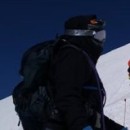
USAKeller (top photo) and sdkeil (with Mt. Harvard behind, bottom photo) on the summit of Mt. Columbia:
Looking west at the Elks (the farther north and west you go, the more snow-loaded the mountains looked):
A view looking back at the ridge that we took up (taken from the summit of Mt. Columbia):
We began the descent, not looking forward to another 6 miles ahead! The wind was higher (up to 20mph) and would not let up until we were back under the trees. We made good time back down to treeline (1.5hrs.) and thought we would try to avoid using snowshoes... but after each of us post-holed to our chest in crusty powder, we chose to put them back on. As the temperature had warmed up throughout the day, the snow softened, and we continually found ourselves still sinking into the snow we had walked on earlier. This was the very last activity we wanted to do. Now, there is a pretty nicely packed-down trail to follow from treeline back to the Colorado Trail junction! It took us 3.5hrs (including stops) to get back to the car, to where we arrived at 6:20pm (temperature: 34 deg.). After an 11-hour day on Mt. Columbia (not our favorite mountain by any means), we were completely exhausted- Crocs have never felt so good on my feet!
It was a fabulous day for sdkeil and I to complete the Harvard group. After Mt. Harvard this past summer, I can speak for both us and say that we weren't terribly excited to return to the area for Columbia... but we were fortunate for this accomplishment, and grateful to see some of the Collegiate Peaks Wilderness in the winter!! What's next?
*NOTE: Although we did not get a good look at Mt. Columbia's standard west slopes, we felt that the southeast ridge run we did is a great route for a winter climb up this mountain. The east ridge from Three Elk Creek TH also looks like a very nice gradual ridge to climb as well.
Thumbnails for uploaded photos (click to open slideshow):
I climbed the route 3 days after you did. I thoroughly enjoyed it. Can you think of another standard 14er route where you walk ridges above timberline for a full three miles? I have climbed Columbia three other times on two other routes; this was my favorite.
The day before climbing this route, I climbed Harvard via Horn Fork basin. I posted a trip reprt. Sorry, no photos.
I agree with you, it is very rare that you can be above timberline on a ridge for that long. It really makes it a different kind of climb and I am surprised this route doesn't get more use. There was a point at 12,800 where we sat down and we both basically fell asleep because the weather was so perfect. As you stated in your trip report, it would totally be a miserable climb though if you were in windy conditions. It was definitely something that we really thought about when considering this route, however we also suspected that the west side may have its avalanche issues so we decided to stay away from that route. Glad we could help out a little and pack down some of a trail. We had the same experience you did on Harvard where you would break through that crusty top every once in a while and sink thigh deep into sugar snow on the way up. However, on the way back down, like you experienced, we broke through that top layer all the way down. Nothing more enjoyable after a long summit run then to have to break trail on the way down.
little trip the two of you had. That ridge sounds like a fun time. A long time spent above treeline. Some good pictures. I espacially like the one of Yale. Congratulations!
Caution: The information contained in this report may not be accurate and should not be the only resource used in preparation for your climb. Failure to have the necessary experience, physical conditioning, supplies or equipment can result in injury or death. 14ers.com and the author(s) of this report provide no warranties, either express or implied, that the information provided is accurate or reliable. By using the information provided, you agree to indemnify and hold harmless 14ers.com and the report author(s) with respect to any claims and demands against them, including any attorney fees and expenses. Please read the 14ers.com Safety and Disclaimer pages for more information.
Please respect private property: 14ers.com supports the rights of private landowners to determine how and by whom their land will be used. In Colorado, it is your responsibility to determine if land is private and to obtain the appropriate permission before entering the property.