Download Agreement, Release, and Acknowledgement of Risk:
You (the person requesting this file download) fully understand mountain climbing ("Activity") involves risks and dangers of serious bodily injury, including permanent disability, paralysis, and death ("Risks") and you fully accept and assume all such risks and all responsibility for losses, costs, and damages you incur as a result of your participation in this Activity.
You acknowledge that information in the file you have chosen to download may not be accurate and may contain errors. You agree to assume all risks when using this information and agree to release and discharge 14ers.com, 14ers Inc. and the author(s) of such information (collectively, the "Released Parties").
You hereby discharge the Released Parties from all damages, actions, claims and liabilities of any nature, specifically including, but not limited to, damages, actions, claims and liabilities arising from or related to the negligence of the Released Parties. You further agree to indemnify, hold harmless and defend 14ers.com, 14ers Inc. and each of the other Released Parties from and against any loss, damage, liability and expense, including costs and attorney fees, incurred by 14ers.com, 14ers Inc. or any of the other Released Parties as a result of you using information provided on the 14ers.com or 14ers Inc. websites.
You have read this agreement, fully understand its terms and intend it to be a complete and unconditional release of all liability to the greatest extent allowed by law and agree that if any portion of this agreement is held to be invalid the balance, notwithstanding, shall continue in full force and effect.
By clicking "OK" you agree to these terms. If you DO NOT agree, click "Cancel"...
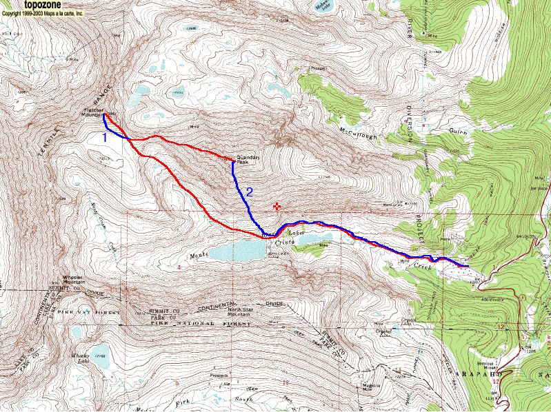
Access from Boulder, CO:
Take CO 9 south (Breckenridge exit) off of I-70.
Turn west onto County Road 850 (Blue Lakes Road) 8 miles south of Breckenridge.
Drive as far as possible.
Fletcher Mountain:
Alek, Luke, and I skinned up Blue Lakes Road and up the narrow hanging valley southwest of Quandary Peak to the Mount Fletcher-Quandary Peak saddle. �Alek skied down from here. Luke and I continued up to Mount Fletcher's summit (13,951'). �We glissed the south face from the summit back to the Fletcher-Quandary saddle. �The snow was heavy powder and the slope angle was about 30 degrees. Elevation: ~700'
Quandary Peak:
Luke and I continued up Quandary's west ridge (Class 3) to the summit (14,265'). �This was more difficult than when I climbed it on July 14, 2004 due to snow, AT boots and skis. �We glissed down the south-facing Cristo Couloir from the summit. �The steepest section approached 45 degrees, but was consistently 35-40 degrees. �The snow was icy up top, but soon became good dust on crust, then soft and wet, but fully supportive. Elevation: ~3,385' Total Elevation: ~4,085'
Cristo Couloir. Photo: Luke Kroiss
Skiing Cristo Couloir. Skier: Brian Kalet. Photo: Luke Kroiss
Annotated Map
Thumbnails for uploaded photos (click to open slideshow):
Comments or Questions
Caution: The information contained in this report may not be accurate and should not be the only resource used in preparation for your climb. Failure to have the necessary experience, physical conditioning, supplies or equipment can result in injury or death. 14ers.com and the author(s) of this report provide no warranties, either express or implied, that the information provided is accurate or reliable. By using the information provided, you agree to indemnify and hold harmless 14ers.com and the report author(s) with respect to any claims and demands against them, including any attorney fees and expenses. Please read the 14ers.com Safety and Disclaimer pages for more information.
Please respect private property: 14ers.com supports the rights of private landowners to determine how and by whom their land will be used. In Colorado, it is your responsibility to determine if land is private and to obtain the appropriate permission before entering the property.