Download Agreement, Release, and Acknowledgement of Risk:
You (the person requesting this file download) fully understand mountain climbing ("Activity") involves risks and dangers of serious bodily injury, including permanent disability, paralysis, and death ("Risks") and you fully accept and assume all such risks and all responsibility for losses, costs, and damages you incur as a result of your participation in this Activity.
You acknowledge that information in the file you have chosen to download may not be accurate and may contain errors. You agree to assume all risks when using this information and agree to release and discharge 14ers.com, 14ers Inc. and the author(s) of such information (collectively, the "Released Parties").
You hereby discharge the Released Parties from all damages, actions, claims and liabilities of any nature, specifically including, but not limited to, damages, actions, claims and liabilities arising from or related to the negligence of the Released Parties. You further agree to indemnify, hold harmless and defend 14ers.com, 14ers Inc. and each of the other Released Parties from and against any loss, damage, liability and expense, including costs and attorney fees, incurred by 14ers.com, 14ers Inc. or any of the other Released Parties as a result of you using information provided on the 14ers.com or 14ers Inc. websites.
You have read this agreement, fully understand its terms and intend it to be a complete and unconditional release of all liability to the greatest extent allowed by law and agree that if any portion of this agreement is held to be invalid the balance, notwithstanding, shall continue in full force and effect.
By clicking "OK" you agree to these terms. If you DO NOT agree, click "Cancel"...
Mt. Helen 13,164'
Route: East Slopes
TH: Spruce Creek
When: 1/22/17
Stats: ~5 miles, 2,750' roundtrip
Partner: Becca
I wanted an adventure on my splitboard. It had been a while. Becca wanted an adventure on her splitboard. It had been a while. Mt. Helen looked really good from the lifts at Keystone on Saturday. We studied the East Slope route that evening, procured the necessary Pop Tart and Lifesaver Gummy trail snacks, and set plans for the next day.
The CAIC forecast Sunday morning was yellow above treeline, and green at treeline and below. Mountain-Forecast called for partly cloudy skies clearing later in the morning, along with 20-35 mph winds. Little did we know that when we arrived at the trailhead, near boot deep powder would await us
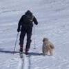
Trailhead
The Spruce Creek trail was well packed, but no one had been up the trail since the new snow had fallen. Skinning through 2" - 8" of fresh stuff with snow still coming down was delightful.
Nick skinning What?? Becca skinning Cool sun
Reaching the Aqueduct Road turnoff, the sun started peaking out a little more.
Wheeler trail turn
We took the hard right turn onto the Aqueduct Road toward the Wheeler Trail and quickly reached the gate. Looking left from the gate, we identified an older skin track heading uphill and finally began gaining some significant elevation.
Bristlecone
The steepest section of this route lies here, between the gate and treeline. A few short cliff bands interspersed in the trees guard the more moderate upper slopes. We departed the old skin track to find a line that steered away from the taller cliffs and steeper slopes.
Gaining the East Face
Above the cliffs, we rejoined the older skin track and followed it until it disappeared near treeline. And just like that, BAM! Upon broking out of the trees, that good 'ole Tenmile Range wind greeted us in earnest.
The remaining skin was straightforward up a consistent, well covered slope. Wind was ever present, whipping us relentlessly in the face. There were a couple short rocky sections to cross at the very top, but we were able to keep skins on from the car to the summit.
Nick on summit Becca on summit Looking toward Quandary Father Dyer. Must. Climb. Ridges.
We decided to de-skin, re-board, and un-pole as fast as possible. Just as we were taking our last pictures and starting to head down, two skiers appeared near the summit. A line of 6 more followed not far behind. We strapped into our boards approximately 200 - 300 feet from the summit and grazed a couple sharks at the start. After that, the remaining riding was just about everything a snow enthusiast could ask for:
Looking northeast Becca and Bald Mountain Sun Becca getting it Yummm Happy
A little windblown and surfy at the top, and gradually softening down lower. We stayed near or within a few hundred feet of the skin track most of the way down until reaching the gate on the Aqueduct Road. From there, we retraced our original skin track down the Spruce Creek trail. It was only necessary to pull out the poles for a really short flat section near the trailhead. Other than that, it was a fast and fun ride down a packed single track all the way back to the car.
What a fun ski! We couldn't stop staring at Helen from across Lake Dillon the rest of the evening.
Thank you to everyone that has posted ski trip reports on this peak previously - your beta was super helpful!
Thumbnails for uploaded photos (click to open slideshow):
Alex - Thank ya sir. And thanks for the tour ideas on Strava that I never would have considered Let's tour sometime, I think I might be able to sort of keep up by now!
Brian - I want Clinton and Lackawanna when conditions permit... let me know if you plan to head out there, or if ya plan on any other mellow peaks any time soon.
Great idea and good report, Nick & Becca!
I'll have to check this peak out soon!
Caution: The information contained in this report may not be accurate and should not be the only resource used in preparation for your climb. Failure to have the necessary experience, physical conditioning, supplies or equipment can result in injury or death. 14ers.com and the author(s) of this report provide no warranties, either express or implied, that the information provided is accurate or reliable. By using the information provided, you agree to indemnify and hold harmless 14ers.com and the report author(s) with respect to any claims and demands against them, including any attorney fees and expenses. Please read the 14ers.com Safety and Disclaimer pages for more information.
Please respect private property: 14ers.com supports the rights of private landowners to determine how and by whom their land will be used. In Colorado, it is your responsibility to determine if land is private and to obtain the appropriate permission before entering the property.


 Trailhead")
 Becca skinning")
 Wheeler trail turn")
 Bristlecone")
 Nick on summit")
 Becca on summit")
 Looking northeast")
 Becca and Bald Mountain")
 Sun")
")
 Becca getting it")
 Yummm")
 Happy")
 Nick skinning")
 What??")
 Cool sun")
 Gaining the East Face")
 Looking toward Quandary")
 Father Dyer. Must. Climb. Ridges.")