Download Agreement, Release, and Acknowledgement of Risk:
You (the person requesting this file download) fully understand mountain climbing ("Activity") involves risks and dangers of serious bodily injury, including permanent disability, paralysis, and death ("Risks") and you fully accept and assume all such risks and all responsibility for losses, costs, and damages you incur as a result of your participation in this Activity.
You acknowledge that information in the file you have chosen to download may not be accurate and may contain errors. You agree to assume all risks when using this information and agree to release and discharge 14ers.com, 14ers Inc. and the author(s) of such information (collectively, the "Released Parties").
You hereby discharge the Released Parties from all damages, actions, claims and liabilities of any nature, specifically including, but not limited to, damages, actions, claims and liabilities arising from or related to the negligence of the Released Parties. You further agree to indemnify, hold harmless and defend 14ers.com, 14ers Inc. and each of the other Released Parties from and against any loss, damage, liability and expense, including costs and attorney fees, incurred by 14ers.com, 14ers Inc. or any of the other Released Parties as a result of you using information provided on the 14ers.com or 14ers Inc. websites.
You have read this agreement, fully understand its terms and intend it to be a complete and unconditional release of all liability to the greatest extent allowed by law and agree that if any portion of this agreement is held to be invalid the balance, notwithstanding, shall continue in full force and effect.
By clicking "OK" you agree to these terms. If you DO NOT agree, click "Cancel"...
| No route description? What?? |
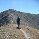
As I start knocking off the 14ers and even the Centennials that are within reasonable driving distance from the metro, I have started to dig even deeper and begun doing the bi-centennials. Had some time this weekend and wanted to do something close. Not gonna get much closer than the Mt Evans area. I tend to over react when there is no route description on this site as I have become quite dependent (probably too dependent) on this site for its excellent resources.
I thought, what the hell, let's just get up there and give it a try. From the topo map it appears to be fairly simple and straight forward. Based on my hike, here is a proper route description for Gray Wolf Mountain.
1. Follow the route description for Mt Spalding from Summit Lake TH.
2. Turn and look due east and wave at the car/goat/hiker/tourist laden summit of Mt Evans.
3. Turn about 90 degrees to your right, looking SSW. Wave to the hoards of hikers on the summit of Mt Bierstadt.
4. Turn 180 degrees and start hiking almost due north.
5. Ignore all of the jeans-clad, single water bottle carrying, newbie experts who say things like, "I bet he is lost, he is going the wrong way; or, I think he's headed over to Grays and Torreys, that's like right over there..."
6. Descend the mostly grassy slope into the valley between Spalding and Gray Wolf.
7. CRITICAL STEP!!! Pay attention to this one, your life, or at least the dryness of your boots, can be at stake here: Try to avoid walking in a straight line across to Gray Wolf. Bow up toward the ridge. This will help avoid traversing through several sections of marshy wet grounds.
8. Hike up the grassy slope of Gray Wolf to the large cairn on the summit. Enjoy what should be solitude in a very busy area.
Seriously though, this is a nice short little hike, somewhere in the neighborhood of 5 1/2 miles rt. Took a very average speed hiker 3 1/2 hours total including Spalding which you can actually avoid but it really does not take much extra time.
|
Caution: The information contained in this report may not be accurate and should not be the only resource used in preparation for your climb. Failure to have the necessary experience, physical conditioning, supplies or equipment can result in injury or death. 14ers.com and the author(s) of this report provide no warranties, either express or implied, that the information provided is accurate or reliable. By using the information provided, you agree to indemnify and hold harmless 14ers.com and the report author(s) with respect to any claims and demands against them, including any attorney fees and expenses. Please read the 14ers.com Safety and Disclaimer pages for more information.
Please respect private property: 14ers.com supports the rights of private landowners to determine how and by whom their land will be used. In Colorado, it is your responsibility to determine if land is private and to obtain the appropriate permission before entering the property.