Download Agreement, Release, and Acknowledgement of Risk:
You (the person requesting this file download) fully understand mountain climbing ("Activity") involves risks and dangers of serious bodily injury, including permanent disability, paralysis, and death ("Risks") and you fully accept and assume all such risks and all responsibility for losses, costs, and damages you incur as a result of your participation in this Activity.
You acknowledge that information in the file you have chosen to download may not be accurate and may contain errors. You agree to assume all risks when using this information and agree to release and discharge 14ers.com, 14ers Inc. and the author(s) of such information (collectively, the "Released Parties").
You hereby discharge the Released Parties from all damages, actions, claims and liabilities of any nature, specifically including, but not limited to, damages, actions, claims and liabilities arising from or related to the negligence of the Released Parties. You further agree to indemnify, hold harmless and defend 14ers.com, 14ers Inc. and each of the other Released Parties from and against any loss, damage, liability and expense, including costs and attorney fees, incurred by 14ers.com, 14ers Inc. or any of the other Released Parties as a result of you using information provided on the 14ers.com or 14ers Inc. websites.
You have read this agreement, fully understand its terms and intend it to be a complete and unconditional release of all liability to the greatest extent allowed by law and agree that if any portion of this agreement is held to be invalid the balance, notwithstanding, shall continue in full force and effect.
By clicking "OK" you agree to these terms. If you DO NOT agree, click "Cancel"...
Peaks: Pacific Peak(13,950'), Atlantic Peak (13,391') Route: Pacific Peak Northeast Slopes Distance: ~9 Miles Elevation Gain: ~3,500' Class: Class 1 & some Difficult Class 2 Crew: emohr, jlarson630 Hike Time: 7 Hours Difficulty: 6/10
It was only a matter of time before I could no longer ignore the call of The Centennial Peaks of Colorado. Pacific and Atlantic Peak have been on my radar for a while for there close proximity, and it was a safe enough route that it wouldn't matter how much snow accumulated from the most recent snowfall. It was heartbreaking to see the changing colors of Fall come and go so quickly with the sporadic weather, but getting the chance to play in the snow is one I will never pass up
Note: There are much more efficient ways to climb Pacific and Atlantic Peaks. Jake & I took "The Coast to Coast Scenic Route". Atlantic's West Ridge, or Pacific's East Ridge are much more direct with less mileage. This basin however, was unbelievably gorgeous
We made our way up The McCullough road quickly, and made it to the trailhead by 7AM. The sun was just peaking it's head over Hoosier Ridge, and the 17 degree weather would be warming up soon
Once we put our fireworks away, we were ready to begin
Sun kissing Quandary Peak
The first section of the trail follows an old road that passes somebody's cabin on the left, and meanders through the woods and lakes to reach a fork where the trail begins and the road ends. The signage is obvious, and the route is still well traveled up to, and beyond this point
Frozen lake in the forest
Sun rising over Quandary's East Ridge
Quandary's impressive North Face
Once we got above the last lake along the trail, we headed South along the trail towards the base of Quandary, and up to a small plateau where we got our first look at The Fletcher-Atlantic Traverse. Simply, breathtaking
Fletcher Peak, Mayflower Grand Traverse, and Atlantic Peak from our basin
Stumbled across an old goat couple. He's Walter, and she's Phylss.
Walter. Or Walt (I need to cut back the Breaking Bad)
After our brief conversation with Walt and Phylss, the trail became less obvious, and we were living the way I love to; one cairn at a time baby
When lost, I will always take advice of the goat
Once we made our way further into the basin, we could see the steep, "Difficult Class 2" slope that led to the saddle between Atlantic and Pacific. Limiting our time in the softening snow, we chose a route up the right side of the gully to maximize our time spent on rock. This route to the right, or North, put us closer to Pacific, so we chose that for our first peak of the day
Gazing off towards our snowy ascent route
Frozen lake below Atlantic, looking at Fletcher
Jake with Quandary behind
My beard got 2cm longer from the first posthole of the season
Once making our way up to the saddle between the peaks, we were greeted with amazing views of the West. We started heading North to get to what we thought was Pacific Peak, but soon found out is just a small hill that is much, much smaller than Pacific Peak. Standing between the two peaks was just unbelievable. I couldn't believe how long that traverse looked! Like just about every hike that "mentally surprises" me, I complained for a solid amount of time, I stopped my complaining, posted my boot in some fresh snow, and got back to the reason of why I was here
Atlantic Peak, The Sawatch Range in the distance, and the lovely tailing ponds of The Climax Mine
Jake pushing up towards Pacific Peak, with Pacific Tairn on the left
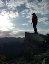
Atop Pacific Peak
The traverse from Pacific to Atlantic was fairly short and uneventful, but I was able to soak in enough of the good mountain vibes to become more appreciative of the day. I look around, and see gorgeous mountains all around me. So what? Welcome to Colorado. We can do that any weekend we want, where we want, and for as long as we want. We're spoiled. It's that simple.
So when I really think about the sentence, "I climbed 2 of the 100 tallest peaks in Colorado," it doesn't take long for the appreciation to set in. I realize this is something some people will never get the chance to do, and to some seems like an impossible goal. But here on 14ers.com, we read reports of Class 5 routes, all the 14ers in a year, and other ridiculously impressive mountaineering goals. It's hard to look back and appreciate climbing/hiking for what it really is, but when I do, I have a much greater appreciation for how blessed I really am
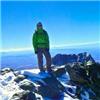
Atop Atlantic
Just more motivation to continue with The Centennials
With tired legs and feet, we started picking our best way down back to the car. The way we had ascended kind of meandered more towards Quandary and Fletcher than we were wanting to hike, so we made a straight shot for the last lake we saw before the trail began it's inefficient ways away from Pacific and Atlantic. Not only did we want to find a more efficient trail down, but we wanted something that would prove more stable than the slushy slopes we had earlier ascended. Jake and I opted to descend Atlantic by one of the large rock gullies South of the normal Northeast Slopes route in order to avoid the larger snowfields. We still found some snow, but nothing we couldn't handle without our butts.
Path of least resistance.
After seeing no one the entire day, we ran into about 25 people in different groups on our way down. I imagine this is a pretty popular hike for the people from Breck considering it's about 10 minutes away. The trail had become soaked with the melting snow, and this might have been the best opportunity to use microspikes throughout the day. Jake and I managed to slip and fall more times on the mud in that one mile of forest more than we did on the other 8 miles of the route
Rock gully
A day in the mountains is a day well spent. I just can't wait to get back
Red-Ascent, Orange-Traverse, Blue-Descent. My drawing skills are really coming together
Thumbnails for uploaded photos (click to open slideshow):
Caution: The information contained in this report may not be accurate and should not be the only resource used in preparation for your climb. Failure to have the necessary experience, physical conditioning, supplies or equipment can result in injury or death. 14ers.com and the author(s) of this report provide no warranties, either express or implied, that the information provided is accurate or reliable. By using the information provided, you agree to indemnify and hold harmless 14ers.com and the report author(s) with respect to any claims and demands against them, including any attorney fees and expenses. Please read the 14ers.com Safety and Disclaimer pages for more information.
Please respect private property: 14ers.com supports the rights of private landowners to determine how and by whom their land will be used. In Colorado, it is your responsibility to determine if land is private and to obtain the appropriate permission before entering the property.


")


 Once we put our fireworks away, we were ready to begin")
 Sun kissing Quandary Peak")
 Frozen lake in the forest")
 Sun rising over Quandary's East Ridge")
 Quandary's impressive North Face")
 Fletcher Peak, Mayflower Grand Traverse, and Atlantic Peak from our basin")
 Stumbled across an old goat couple. He's Walter, and she's Phylss.")
 Walter. Or Walt (I need to cut back the Breaking Bad)")
 When lost, I will always take advice of the goat")
 Gazing off towards our snowy ascent route")
 Frozen lake below Atlantic, looking at Fletcher")
 Jake with Quandary behind")
 My beard got 2cm longer from the first posthole of the season")
 Atlantic Peak, The Sawatch Range in the distance, and the lovely tailing ponds of The Climax Mine")
 Jake pushing up towards Pacific Peak, with Pacific Tairn on the left")
 Atop Pacific Peak")
 Atop Atlantic")
 Just more motivation to continue with The Centennials")
")
 Path of least resistance.")
 Rock gully")
")
")
 Red-Ascent, Orange-Traverse, Blue-Descent. My drawing skills are really coming together")