| Peak(s): |
Handies Peak - 14,058 feet Wetterhorn Peak - 14,021 feet |
| Date Posted: | 09/27/2013 |
| Modified: | 04/11/2014 |
| Date Climbed: | 09/20/2013 |
| Author: | jchapell |
| Additional Members: | SnowDog |
| Peak(s): |
Handies Peak - 14,058 feet Wetterhorn Peak - 14,021 feet |
| Date Posted: | 09/27/2013 |
| Modified: | 04/11/2014 |
| Date Climbed: | 09/20/2013 |
| Author: | jchapell |
| Additional Members: | SnowDog |
| San Juan Part 1: Summer, Fall... |
|---|
|
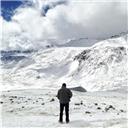
We landed in Denver on Thursday the 19th around 5pm. After dinner with family and a trip to REI for fuel, we drove to Salida. We headed down 285 from the Denver area around 9pm, but the anticipation of the mountains and aspens surrounding us in the darkness gave us some energy for the drive. After a 6 hour hotel stay, we were back on the road to Lake City and the American Basin Trailhead. We were in a stock rental Nissan Pathfinder 4WD, so we were curious how far we would get up the 2WD and possibly 4WD road. We weren't sure how the Aspens would be changing after hearing mixed reviews at this point in the year, but we observed about of the aspens turning or bright yellow. Technically, the trip would wrap summer and fall, with the first day of fall being 9/22. It made for a beautiful drive, and especially in the twisting cliffs of the road up to American Basin. We saw a few deer on the way, the first of many on the trip. We made it (slowly) up to the cutoff for the 4WD road, and continued ahead, with barely any hiccups (just lots of jostling). The 4 hr drive from Salida meant that we were starting around 10am, but it was a bluebird day with not a cloud in the sky, so we weren't very concerned about the weather. We joined a couple other cars and set off. I have .gpx files for the Handies Route too, but PM me for copies (I can upload 1 gpx per TR). I also have additional videos and GPS waypoints that could be helpful if you are planning a trip. Handies Peak via American Basin Upper 4WD TH 9/20/2013, 10:45am: 5.03 miles 2,669 feet Total Time: 5 hrs (~3 up, ~1.5 down)  NOTE: At this point, we were only ~15 hours from being at home at 600 feet above sea level, and we planned to use Handies as an acclimatization hike. I was also 5 days removed from wearing an immobilization boot for a month from a sprained midfoot, so we hoped this would give us an idea of what we could expect for the rest of the trip. The trail begins with a very modest altitude gain for the first mile or so along the basin, but even the low incline had us huffing our flatlander lungs. The first part of a hike is usually the toughest for my wife and I - getting in the zone, finding our common pace, adjusting gear/shoelaces/camera/etc usually takes 20-30 minutes to even out. Soon after we really got going we met 14er SnowDog, who was descending with his two dogs from having knocked out American Peak, Jones Mountain, and Niagra Peak as he's working on the Centennials...at least I think it was all three. It was cool to meet him and his pups. The trail couldn't be clearer, and led us deeper the extensive basin, bearing eventually east (climber's left) around Handies itself, where the route flattens out near Sloan Lake. We had lunch there with great views of the cliffs of American Peak. We refer to all Marmots by the first name "Beaver" and Pikas "Marmot" after a slight mis-identification a few years ago;) They were all over the place at this point of the hike. Soon after, the uphill begins in earnest. The switchbacks largely avoid any loose stuff, which we were thankful for. About 20 minutes into this, we were amazed to look back and see a mountain biker, ON his bike, GAINING on us! He passed us about 20 minutes later and continued (some on, some off bike) to the summit. After reaching the summit, we eagerly got a few summit shots including those we hoped to summit on the trip: Wetterhorn, Uncompahgre, and Sneffels. ")  The views were unobstructed, and it was a great intro to what is in store for us in the San Juans! The mountain biker gave us some good commentary - he had been to the top of Handies on bike something like 10+ times and was heading back down the Grizzley Gulch route. He was the only other person on the Summit, and once he left, we had the summit to ourselves -- we had an amazing trip of relative solitude on the mountains -- for about 20 minutes. We threw back some trail mix, shot blocks, and "bars" (too many bars this trip to identify), and enjoyed the scenery.  Eventually, with the day getting away and a full schedule for the evening we made our way down. After a few more photo opps at the base, we headed out (with some scuffs and scrapes on the road), with pockets of gorgeous Aspens lining the way. We also met a group of (I assume) young bighorn sheep on the way. We also passed Camp RedCloud, where I had gone in highschool - but had no idea we were in the same area!  ") In Between... We drove to Lake City, got some Naked drinks, food, check weather/directions, and use the facilities, and headed back out towards Matterhorn Creek. The Aspens were un.real.  FYI, while the website and Roach make it sound like the 4WD trailhead is a turn at the parking for the 2WD parking area at Matterhorn Creek, the turn is BEFORE the parking area. We debated this for a few minutes before my wife accurately made the decision (um, duh). The road was better than the American Basin 4WD TH, and got us to the top in ~15 minutes. To this point, we had only used our day packs, so it took us 30 min or so to pack up my larger pack w the tent, sleeping bags, etc, and get going. At that point it was already dusk, we were tired and hungry, and ready to get settled! We were hoping, if everything went perfectly, to knock out Wetterhorn, traverse to Uncompahgre, and make our way back to the campsite the next day. This is a 16+ miles hike, so we knew it may not be possible. However, after reading about the high metal content in the water that didn't filter out, I also made the decision to bring 9L total water between us - that's a lot of extra weight! As well as 2 extra food, clothes, etc... We didn't know yet if we were going to hike to treeline, past treeline to the Uncompahgre junction, or what, but we set off with a fast pace. After only a half mile, we saw some other campers and stopped to talk to them. They pointed out an excellent site not far from theirs, and we took it. The location was about 38.037121 -107.492066. We made quick work of the tent, Mountain House Chicken & Rice, and food bag/hanging preparations, and my wife went to bed around 9. I stayed up another hour or so trying out some star photography - not great results, but a few that weren't totally off:    Wetterhorn Peak via Matterhorn Creek 9/21/2013 6:30am (mileage from upper TH, time from campsite): 7.52 miles 3,605 feet Total Time: 8.5 hrs (~4 up, ~4 down w several leisurely breaks) DON'T MISS THE DIRECTIONS NOT LISTED IN THE ROUTE OR ROACH: Per this link, turn right at the Ridge Stock Tr 233 a little below treeline, it is the right choice: http://www.14ers.com/php14ers/tripreport.php?trip=14282&parmpeak=Wetterhorn+Peak&cpgm=tripmain&ski=Include After waking up in the tent (it was around 39F), we quickly made some oatmeal and coffee, prepped our gear and set out around 6:30. The day started beautifully with the full moon, with the view first of Coxcomb, then Matterhorn, and eventually Wetterhorn slowly lit by the rising sun. The perfect alpinglow to get the party started! You cannot ask for more than mornings like this.  After about an hour of hiking through the mellow basin, Uncompahgre began to show it's giant head over the hillside.  Stepping up into the boulderfield felt like something out of Middle Earth - and we also decided a great bathroom spot (don't worry, no trace was left).  and Matterhorn (R)") Leaving the boulder field and beginning the uphill onto the ridge, we began to get even better views of our path, the prow, and our eventual summit, as well as Uncomp behind us.  About the time we gained the ridge, we met up with the group we had camped beside the night before. We seemed to move at a similar pace, and discussed going the rest of the route together. Ernie (Father), Joe (son), and Ty (Friend) -- I'll add their 14ers names later -- joined in as we helmetted-up and continued the hike. They were on the tail end of a trip after driving up from Dallas to hit several 14ers. Joining up with them was a highlight of the trip, as we shared the effort as well as food, great conversation, nicknames, and baseball trashtalk.  After passing the yellow dirt area, the route becomes more of a scramble and route finding requires a bit more concentration. We stashed our poles and Ernie took the lead finding the route, and I took the lead. As we continued on going over/around/through rocks, I was struck by how blessed we were to be out on a spectacular day with eye-popping views of creation, exciting physical and mental challenges, enjoyable company, and (personally) my unbelievable wife.  After reaching the slab, we got ready for each of us to head up - Ernie, Joe, Suzanne, and me. As many have mentioned, the photos of this area are great to impress friends, but it is much less intimidating in real life. We staggered to prevent kicking rocks on eachother, but scurried up without incident.    After this, there is a bit of a ledge walk, and a small (and somewhat loose) 30 foot scramble that brings you to the summit.   We took the summit as a team, and enjoyed our hard work!      The descent was more than just backtracking - it was enjoying the fruits of a rewarding climb.    Oh ya, we threw out the Uncompahgre combo idea a looooooong time ago. We were too busy enjoying cheese and sausage breaks and sampling trail mix to get on our horses for an additional 10 miles...After getting back to camp, we loaded up, said some goodbyes, and headed out. We gave a ride to a hiker from the 4wd TH to the lower TH - it was his first 14er, and he HAD done the 12 hr Wetterhorn/Uncomp traverse - no backpack, only water. Wow. In between... There was a giant part of our vacation dealing with a flat tire in Lake City that cost us 9 hrs and something like 400 miles of driving...I'll save the details, but we headed to Telluride on a donut spare tire going 45 mph --- and PASSED A GIANT MOUNTAIN LION ON THE ROAD! We stopped, which made it crouch down low on the road right beside the car, but then it ran away before we could get pictures... Then there was the meaningful storm on 9/22/2013...this was our rest day, but the flat tire situation forced us out on the road as the storm was beginning... The trip continued to Mt Sneffels, and our Summer/Fall trip suddenly turned to winter on Sneffels (Trip Report here)... Thumbnails for uploaded photos (click to open slideshow):  Setting off through American Basin")
 Sneffels, center (right? or is it Capitol?)")
 Left to Right: Coxcomb, Wetterhorn, Uncompahgre")
 American Peak in the background")
")
 Young Bighorn Sheep (we think)")
 Afternoon glow")
 The sky from our tent")
 The ridge overlooking our campsite")
 Wetterhorn peaking over Coxcomb at night")
 Matterhorn Alpinglow")
 Uncompahgre Rising Up")
 Boulderfield between Wetterhorn (L) and Matterhorn (R)")
")
")
")
 Waiting on the slab for our turn up")
 My wife is amazing")
")
")
 The final scramble to the summit")
 Chimney Rock and Courthouse Mountain")
 I think Sneffels dominates the center, but could be Capitol")
 Uncompahgre over Matterhorn's shoulder")
")
 Uncomp behind us")
")
")
 Our crew, and our summit.")
|
| Comments or Questions | |||||||||
|---|---|---|---|---|---|---|---|---|---|
|
Caution: The information contained in this report may not be accurate and should not be the only resource used in preparation for your climb. Failure to have the necessary experience, physical conditioning, supplies or equipment can result in injury or death. 14ers.com and the author(s) of this report provide no warranties, either express or implied, that the information provided is accurate or reliable. By using the information provided, you agree to indemnify and hold harmless 14ers.com and the report author(s) with respect to any claims and demands against them, including any attorney fees and expenses. Please read the 14ers.com Safety and Disclaimer pages for more information.