Download Agreement, Release, and Acknowledgement of Risk:
You (the person requesting this file download) fully understand mountain climbing ("Activity") involves risks and dangers of serious bodily injury, including permanent disability, paralysis, and death ("Risks") and you fully accept and assume all such risks and all responsibility for losses, costs, and damages you incur as a result of your participation in this Activity.
You acknowledge that information in the file you have chosen to download may not be accurate and may contain errors. You agree to assume all risks when using this information and agree to release and discharge 14ers.com, 14ers Inc. and the author(s) of such information (collectively, the "Released Parties").
You hereby discharge the Released Parties from all damages, actions, claims and liabilities of any nature, specifically including, but not limited to, damages, actions, claims and liabilities arising from or related to the negligence of the Released Parties. You further agree to indemnify, hold harmless and defend 14ers.com, 14ers Inc. and each of the other Released Parties from and against any loss, damage, liability and expense, including costs and attorney fees, incurred by 14ers.com, 14ers Inc. or any of the other Released Parties as a result of you using information provided on the 14ers.com or 14ers Inc. websites.
You have read this agreement, fully understand its terms and intend it to be a complete and unconditional release of all liability to the greatest extent allowed by law and agree that if any portion of this agreement is held to be invalid the balance, notwithstanding, shall continue in full force and effect.
By clicking "OK" you agree to these terms. If you DO NOT agree, click "Cancel"...
Peaks: Mt. Eva(13,130'), Parry Pk A (13,391'), (Unranked)Mt. Bancroft(13,250') Route: Chinn's Lake Loop Distance: ~6.5 Miles Elevation Gain: ~3,300' Class: Class 1 & Class 2 Crew: emohr, Hank, Kyle, Takota Hike Time: 5 Hours Difficulty: 4/10
With school and consistently crappy weather hampering any plans to go to the mountains lately, I made sure I used my Thursday off from class to go play for a little bit. I'm hoping I can use my Thursdays to explore some of the Front Range 13ers. 13er Thursdays are my gateway to the hipster realm, one peak at a time. I knew Hank had to be back to class by 2, so I wanted to do something close by, and the Eva/Parry loop looked perfect. It's only an hour away and is only class 2, so it wouldn't present any problems if we ran into more snow than we were expecting. Hank, Kyle (both Mines students), Takota, and I made it to the the Sherwin Lake Dam just as the sun was starting to light up the mountain sides. The trail we started on is at the far North end of the Dam in between Chinn's and Sherwin Lakes. The road up to Chinn's Lake is Beast Mode to say the least. It may not be Lake Como, but this isn't one of those roads where "Oh your Subaru could probably make it bro"
The trail above Sherwin Lake was faint, and disappeared from time to time. We kept the bushwhacking to a minimum, and followed the drainage wherever we could avoid the willows. The temperature was low and the views were grand. Nothing peaks the sense of adventure like a faint 13er trail few people have traveled
Once we made our way above the lakes, the sun slowly peaked its way over the East horizon and began to warm up the cool air. Not a cloud in the sky, aspens turning yellow in the valley, and ice forming along the banks of the streams; Fall hiking has finally begun
Chillin
Takota appreciating the sunrise
One of the few willow sections we had to cross
Once we got above Slater Lake, we started to see more snow drifts, and most of the small pools of water below the willows had completely frozen over. We hung to the South side of the ridge to avoid any chance of getting our feetsies wet
Last remnants of Summer along Mt. Eva's slopes
Progressing through the basin. Slater Lake to the lower left
Frozen ripples
The wind started to pick up once the sun was over our heads, so we put on the wind breakers, and pushed onwards towards the saddle below Mt. Eva. We might not have taken the most efficient route, but we got a little distracted by the herd of big horn sheep we saw
Enduring some wind on our way to the saddle
Minimal snow crossings
And they just kept running
and running!
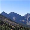
Mt. Eva in the distance
Mt. Evans, The Sawtooth, and Mt. Bierstadt to the South
Gore Range
Simple slope up to Mt. Eva
It was pretty interesting to see the debris left behind from whatever the heck was happening on Mt. Eva. It looked like a big propellor was attached to the fallen tower, and the floors had fallen out in the building. We checked out the cool debris for a bit, investigated the building, and started making our way towards Parry Pk A. Hank and I kept getting distracted by all the cool rocks along this ridge. It took Hank about 50 feet of hiking with a 15lb quartz rock to realize it just might not be worth it
Blown over radio tower
13er summiters. I feel more hip already!
The traverse to Parry Pk A that looks much longer than it really is
Looking back at Mt. Eva
Once we finished the slog up to Parry Pk A, we were greeted with awesome views of Rocky Mountain National Park, and realized we had 360 degree awesome views from here; Evans, Bierstadt, Grays, Torreys, Gore Range, Winter Park, Rocky Mountain, Longs Peak, and of course the awesome basins we had been climbing around all day
Summit of Parry Pk A
Looking North towards Rocky Mountain
Final ridge back down to the lakes
We finally made our way to the drainage that led down to Fall River Reservoir, and it was quite a bit steeper than I was expecting. I slid out several times and I imagine this would be pretty tough to ascend. Unfortunately for Hank, once we reached the bottom, he realized he left his camera near the top.. so Kyle, Takota, and I fetched the X-Terra, and brought it around to Fall River Reservoir to pick up Hank once he retrieved his camera
Moon making its way down to the horizon
Forest shrubbery
Where we came out after descending Mt. Bancroft
Mt. Eva's East Ridge behind Fall River Reservoir
Waterfall we found while searching for the car
We ended our day feeling tired, but satisfied. The mountains prove to be the perfect cure for the real world once again
Thumbnails for uploaded photos (click to open slideshow):
That's one for the books, nice job on the loop! I did it the opposite direction and finished with Witter. Either way it's a fine loop on the divide. Chinn's Lake basin looked like a tough one to plow through, I got my money's worth coming down the side of Witter between the 2 lakes, but cutting the slopes over to Fall River Res was murder.
Thanks so much for your TR. We pretty much followed the route, though think we may have gotten slightly off trail on the descent from the saddle of SE Bancroft Ridge. Not that there is much of a trail to begin with from SE Bancroft down to Fall River Res. A few things I would like to add that I thought might be helpful. Last 2 miles of Rainbow Rd is a bit rough and slow going, but would rank the 4WD road as a 3 of 6, Easy 4WD. There were 2 Subarus, a 4Runner, Tacoma, Xterra and a Jeep Grand Cherokee all at the Fall River Reservoir. Our stock Wrangler made it with ease. Pretty easy to find the trail from the reservoir up to Chinns Lake which is in the SSE corner of the Reservoir.We chose a clockwise route from Fall River Res. Our times: Fall River Res to Mt Eva 140 minutes, Eva to Parry 45 minutes, Parry to Bancroft 40 minutes and 90 minutes back down to TH from Bancroft summit. Total time with 32 minutes of stops on the 3 summits was 5 hours, 40 minutes. The descent from the saddle of SE Bancroft Ridge is a bit steep, and you may have to do some route finding, but was mostly stable as we just followed the gully. Total mileage was 6.91 per my GPS and 3335 elevation gain total. Starting at Fall River Reservoir is ~10830 Elevation.
Caution: The information contained in this report may not be accurate and should not be the only resource used in preparation for your climb. Failure to have the necessary experience, physical conditioning, supplies or equipment can result in injury or death. 14ers.com and the author(s) of this report provide no warranties, either express or implied, that the information provided is accurate or reliable. By using the information provided, you agree to indemnify and hold harmless 14ers.com and the report author(s) with respect to any claims and demands against them, including any attorney fees and expenses. Please read the 14ers.com Safety and Disclaimer pages for more information.
Please respect private property: 14ers.com supports the rights of private landowners to determine how and by whom their land will be used. In Colorado, it is your responsibility to determine if land is private and to obtain the appropriate permission before entering the property.


")
")
 Chillin")
 Takota appreciating the sunrise")
 One of the few willow sections we had to cross")
 Last remnants of Summer along Mt. Eva's slopes")
 Progressing through the basin. Slater Lake to the lower left")
 Frozen ripples")
")
 Enduring some wind on our way to the saddle")
 Minimal snow crossings")
 And they just kept running")
 and running!")
 Mt. Eva in the distance")
 Mt. Evans, The Sawtooth, and Mt. Bierstadt to the South")
 Gore Range")
 Simple slope up to Mt. Eva")
 Blown over radio tower")
")
 13er summiters. I feel more hip already!")
 The traverse to Parry Pk A that looks much longer than it really is")
 Looking back at Mt. Eva")
 Summit of Parry Pk A")
 Looking North towards Rocky Mountain")
 Final ridge back down to the lakes")
 Moon making its way down to the horizon")
 Forest shrubbery")
 Where we came out after descending Mt. Bancroft")
 Mt. Eva's East Ridge behind Fall River Reservoir")
 Waterfall we found while searching for the car")