| Peak(s): |
Del Campo Peak - 6610 |
| Date Posted: | 09/13/2013 |
| Date Climbed: | 09/08/2013 |
| Author: | Aubrey |
| Peak(s): |
Del Campo Peak - 6610 |
| Date Posted: | 09/13/2013 |
| Date Climbed: | 09/08/2013 |
| Author: | Aubrey |
| Del Campo Scramble, North Cascades, WA |
|---|
|
Summit Elevation: 6,610' Round-Trip Distance: 11 miles Total Elevation Gain: 4,300' Class 3-4 scrambling Weeks ago, while hiking Mt. Dickerman off the Mountain Loop Highway in Washington, we saw some rather dramatic-looking mountains across the valley. One of them was Sperry Peak, which, according to SummitPost, rises 3,000 feet in a half mile on its north face and 2,000 feet in one-third of a mile on its east face (as a comparison, Longs Peak rises 2,500 feet above Chasm Lake in about a half mile). But as amazing as Sperry Peak looked, one of its neighbors caught our attention even more. It wasn't until I got home that I figured out the name of this blocky mountain: Del Campo Peak.  Del Campo, Morning Star, Sperry and Vesper from Mt. Dickerman: 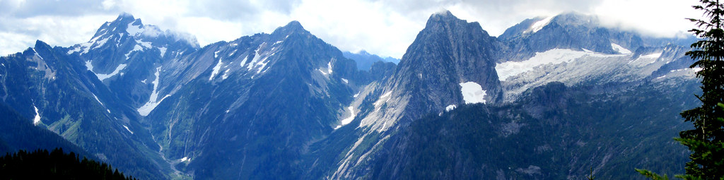 Jen and I had been talking about doing some sort of hike in the Gothic Basin area, as we've heard it's a pretty magical place. We first looked at climbing Gothic Peak, but we kept coming back to Del Campo Peak because the scrambling sounded much better. Just as we made our decision, I got a text from our friend Ben asking what adventure we had planned for the weekend. It didn't take much arm twisting to get him and his new wife, Amanda, to join us. They recently moved to Seattle from Boulder. The climbing guidebook I have says Del Campo is a class 3 scramble, but as I've written in previous reports, class ratings seem to be all over the place in Washington. When Ben texted, "I see 4th class. (Should I bring a) rope for rappel?" I got a little concerned. After doing some more research, I found some sources that gave this climb a class 4 rating. Adding to the ambiguity of it all, route descriptions were vague and contradictory. Of course, we decided to give it a go anyway. Even though it's just a mere 2 hours from our home, Jen and I spent a cozy night sleeping in the back of the Xterra at Barlow Pass. When I heard a car drive up the gravel road around 7 a.m., I knew it was Ben and Amanda. The first mile or so is a flat decommissioned road, but after that, the trail wastes no time gaining elevation. Soon thereafter, we were afforded some expansive views of the valley, and we passed many idyllic waterfalls along the way.  Gothic Basin was even more beautiful than I expected. We arrived just as some campers were starting to rustle. A web of trails went every which way, so I asked some campers the best way to Foggy Lake (which is at the base of Del Campo). Curiously, none of them had even heard of Foggy Lake. One lady said, "We saw some people march up that way yesterday, and they spent a really long time up there." So that's where we went.    We contoured the east side of the lake and went up Del Campo's southeast ridge, which made a nice ramp up to the talus and scree below the summit block.     .")   The closer we got to our intended gully, the more imposing the summit block became.    One route description I read said the easiest way up is to "go just past the notch at the top of the gully, then head straight up the rock to the left." Once we got there, though, it just didn't seem right, and it seemed to exceed class 4. "No way," I said. "I am not going up that." Amanda was with me, so we hung out while Jen and Ben searched around for a doable route.  Jen suggested going back down the gully to find a better way, and I liked that idea much better. But before we started down, I had them pose for a 3-photo pan.  Not far back down the gully, we found a pretty good ledge to gain access to the steep, stepped rocks above the gully's notch. It was a bit exposed, though.  The arrows in the following photo roughly outline our path.  From here to the summit, I didn't take too many photos, as I was concentrating on climbing ... and staying alive. Here's one Ben took of me:  For the most part, the rock was pretty good, though holds still needed to be tested, as there were some loose ones in the mix. After almost 5 hours of hiking, talus hopping and scrambling, we gained the small and airy summit.    The views were spectacular, the weather was nice (albeit a bit hot), and the people we met on top were really nice. We even met some other Colorado folks up there! After fueling up and soaking in the 360 degrees, we carefully made our way back down.  , me and Amanda down climbing. Photo by Ben.")      Overall, this was an exhilarating climb with lots of routefinding and scrambling challenges, and Jen and I really enjoyed tackling them with Ben and Amanda. Thumbnails for uploaded photos (click to open slideshow):  North face of Del Campo Peak.")
")
")
")
 Del Campo Peak and Foggy Lake.")
 Hiking along the shore to the southeast ridge.")
 Gothic Peak")
 Valley view")
 Jen hiking up the southeast ridge; Foggy Lake below.")
 Mountains to the south (shot this photo right into the sun, so it's a bit washed out).")
 Amanda and Ben hiking up the talus; Gothic Peak in the background.")
")
")
")
")
 As I watched Jen and Ben look for a good route, I discovered my threshold for unroped climbing.")
")
")
")
")
 Jen, me, Ben and Amanda on the summit.")
")
")
")
 Jen (barely visible), me and Amanda down climbing. Photo by Ben.")
")
 Looking back at the talus slope. Climbers circled.")
 Descending back through Gothic Basin.")
 Trailside wildflowers.")
 The long hike back to Barlow Pass.")
|
| Comments or Questions | ||||||
|---|---|---|---|---|---|---|
|
Caution: The information contained in this report may not be accurate and should not be the only resource used in preparation for your climb. Failure to have the necessary experience, physical conditioning, supplies or equipment can result in injury or death. 14ers.com and the author(s) of this report provide no warranties, either express or implied, that the information provided is accurate or reliable. By using the information provided, you agree to indemnify and hold harmless 14ers.com and the report author(s) with respect to any claims and demands against them, including any attorney fees and expenses. Please read the 14ers.com Safety and Disclaimer pages for more information.


