| Peak(s): |
Kit Carson Peak - 14,167 feet Challenger Point - 14,086 feet |
| Date Posted: | 09/10/2013 |
| Date Climbed: | 09/07/2013 |
| Author: | michaelgrundy |
| Additional Members: | rohit |
| Peak(s): |
Kit Carson Peak - 14,167 feet Challenger Point - 14,086 feet |
| Date Posted: | 09/10/2013 |
| Date Climbed: | 09/07/2013 |
| Author: | michaelgrundy |
| Additional Members: | rohit |
| North Ridge - The Classy way up Kit Carson |
|---|
Route StatsMountains: Kit Carson Peak, Challenger Point Route: Kit Carson North Ridge -> Kit Carson Ave -> Challenger Point Party: MichaelGrundy, Rohit Date: 09/07/2013 Start: 2:00 AM Finish: 1:00 PM The StoryKit Carson and Challenger point was not a pair that was high on my priority list for this season... as a matter of fact, they didn't even appear on my radar. I had a lot of peaks planned this year and have gotten around to most of them but some of the planned peaks still eluded me. On the list for this fall was the Maroon Bells including the traverse; however, the plans fell through due to scheduling conflicts with other parties involved so we had to postpone until a later time. After looking around for a pair of mountains that we could do on this particular weekend, we were leaning towards doing the Castle/Conundrum hike. Enter a thread titled "Best Non-Standard Routes" to which a few members contributed "North Ridge of Kit Carson". As I read through the description, I became immediately fixated on attempting this route. I pitched the idea to Rohit and after some discussion, we decided that it would be great experience for doing other routes that we want to complete. All of a sudden, Friday could not come fast enough. Finally... Friday! I met Rohit at the park and ride and immediately departed for Crestone. The plan was to get down there at a decent time, set up camp, and get a few hours of sleep before attempting the route as a day hike. Rohit and I are no strangers to the oober alpine starting time of 2 AM, having done several mountains this year that early. After grabbing some dinner in Salida, we rolled into Crestone and up to the Willow Creek trailhead by 8 or so. On the trip down it had been raining off and on, but with a good weather forecast for the next day, we were not deterred. We quickly set up camp, got things organized for our early departure, and hit the sack. 1:30 AM is never a great time to be waking up, even if it IS for a hike. We got geared up, had some breakfast, and started up the trail by 2:00 AM. We kept our heads down and quickly made our way up the 4.75 miles up to Willow Lake by 4:15 AM. I noticed a lot of tents near the trail and tried to keep our lights off them as we passed but if we woke you up, I am sorry! We took a 15 minute break to get some food and then we started around the lake. We crossed the stream, started to ascend up the slope, and then stopped to figure out where we needed to go in order to get into position for the North Ridge. After many looks at the route description, we decided that we needed to head south east towards the silhouette we could see in the distance. After a little willow bashing, we took another pause to gauge where we were and, after several more minutes, decided we had no idea if we were in the correct position or not. $h!t It is never fun when you realize you don't know where you are in relation to geographic features you are to use as a guide. The cliff bands that we were supposed to below were nowhere in sight, nor were the boulders we were supposed to be above. The decision we came up with was to stay put until we could see better. We turned off our headlamps, put on another layer, and laid down on a rock to gaze at the stars for 30 minutes or so. We were even able to witness a few shooting stars during our timeout!   Close to 5:45 AM we were able to look around and make out the features that we were looking for. Above us, the cliff bands! Success! We were exactly where we needed to be, so we decided to keep moving along the bottom of the bands as described. After 15 more minutes of hiking, we started to go uphill and make our way to what we thought was the correct spot. We evaluated where we were headed, and after looking at the map that we had, we decided that we started uphill too early and were off-route. Rather than going back down the hill and then regaining, we decided to make a straight shot for the end of the ridge. This paid off and after about 15 min of traversing the hillside, we were at the bottom of the Outward bound Couloir. Time to throw on the helmets!  The climb up the couloir started a little more loose than I was hoping for, but we were able to leave the couloir pretty quickly and begin our trek up to the ridge proper without any incidents!   Once on the ridge, the steepness went way up and so did the exposure level. Honestly, I was having way too much fun to even notice what the exposure was really like.    The rock was amazing, the steepness was fun, and the excitement grew as we were making our way up the ridge. At no time did I feel nervous or apprehensive about where we were. Honestly, being up there felt AWESOME!   In what seemed like an instant, we were topping out on top of the summit plateau and began the easy stroll over to the summit!  Success! We achieved our first real class 4 route! We felt great, our legs were still in good shape, and we saw some amazing scenery! After some food, our obligatory summit photos, a shot, and some updates to our loved ones, we started our way down in search of Kit Carson Avenue.   In preparation for this hike, I read that a bunch of people end up missing the turnoff for Kit Carson Avenue. Knowing this, as we descended the wide gulley, I was keeping a close eye out for the turn off. After we spotted a cairn sitting off to the side, we made our way to it to find the Ave and our entry point for the hike over to Challenger Point.   There was a little bit of hail accumulation on south side, but nothing to worry about. We stopped and talked with a pair of hikers that were on their way over to KC and explained to them the route that we encountered and continued on our way. We rounded the bend and saw a group of people coming up the from the saddle of Challenger point. We also noticed even more snow on this particular section. Some of the hikers were worried that it was this bad or worse past this section, but Rohit and I explained that this was the worst of it. We continued past and made it to the saddle.  The hike from the saddle to the summit of Challenger was not really a big deal and we made good time to the summit. Finally, we topped out on Challenger point, 45 minutes after we left the summit of Kit Carson peak! More food, shots, photos, and updates to loved ones ensued, and shortly after we got there, we started our descent to Willow Lake and eventually the car.    The hike down from Challenger point... was loose. Honestly, that stuff was way worse than the class 4 route we ascended. We both decided that we didn't have to be on this slope twice and automatically felt bad for those that did. The constant sliding finally caught up with me and I even slipped once and hit my backside on a rock. Not the best way to descend a mountain I might add. Another 40 minutes of descent later and we were down to the waterfall, taking pictures, changing socks, and treating water.    We saw that it was 11:30 AM and decided to try to kick it in high gear and get down. I needed to be in Denver for a 5:30 dinner for a birthday celebration, and Rohit needed to be in Fort Collins around 6. We started our way around the lake, and then down the approach toward the trailhead.  We made great time and were walking into the parking lot by 1:10 PM. Time to pack up camp and get on our way home!  This hike has to be one of my favorites so far. Honestly, the scenery isn't the best I have encountered. I mean, the range isn't as pretty as the San Juan's (in my opinion), but the route made up for it 10 fold! The route, partnered with a great hiking companion, and you have a recipe for an amazing day in the mountains! It's amazing how liberating a route like that can make you feel! This has to be my favorite route to date! Thumbnails for uploaded photos (click to open slideshow):  Looking back down the valley")
 First light, looking up the valley")
 Entry to the Couloir - photo by Rohit")
 Showing the steepness at the beginning of the ridge.")
 Rohit coming up the bottom of the ridge.")
 Looking West from the ridge.")
 Rohit on steeper terrain.")
 Me on the ridge with some fun camera work. - Photo by Rohit")
 Having a blast!")
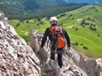
 Me with the angle of the ridge in perspective.")
 The summit plateau")
 On top of Kit Carson")
 Crestone Peak and Crestone Needle")
 Looking up the Avenue towards Challenger")
 Turned the corner and saw some hail on the Avenue.")
 More hail accumulation on the way to the saddle.")
 Plaque on top of Challenger Point")
 Challenger Point summit picture!")
 Kit Carson in the foreground and the Crestones in the background.")
 Rohit above Willow Lake")
 Willow Lake")
 Treating water for the hot trip out. - Photo by Rohit")
 Looking back on Willow Lake")
 Getting close to the trailhead, a picture of how large the mountain really is. - Photo by Rohit")
|
| Comments or Questions | ||||||||||||||||||
|---|---|---|---|---|---|---|---|---|---|---|---|---|---|---|---|---|---|---|
|
Caution: The information contained in this report may not be accurate and should not be the only resource used in preparation for your climb. Failure to have the necessary experience, physical conditioning, supplies or equipment can result in injury or death. 14ers.com and the author(s) of this report provide no warranties, either express or implied, that the information provided is accurate or reliable. By using the information provided, you agree to indemnify and hold harmless 14ers.com and the report author(s) with respect to any claims and demands against them, including any attorney fees and expenses. Please read the 14ers.com Safety and Disclaimer pages for more information.