Download Agreement, Release, and Acknowledgement of Risk:
You (the person requesting this file download) fully understand mountain climbing ("Activity") involves risks and dangers of serious bodily injury, including permanent disability, paralysis, and death ("Risks") and you fully accept and assume all such risks and all responsibility for losses, costs, and damages you incur as a result of your participation in this Activity.
You acknowledge that information in the file you have chosen to download may not be accurate and may contain errors. You agree to assume all risks when using this information and agree to release and discharge 14ers.com, 14ers Inc. and the author(s) of such information (collectively, the "Released Parties").
You hereby discharge the Released Parties from all damages, actions, claims and liabilities of any nature, specifically including, but not limited to, damages, actions, claims and liabilities arising from or related to the negligence of the Released Parties. You further agree to indemnify, hold harmless and defend 14ers.com, 14ers Inc. and each of the other Released Parties from and against any loss, damage, liability and expense, including costs and attorney fees, incurred by 14ers.com, 14ers Inc. or any of the other Released Parties as a result of you using information provided on the 14ers.com or 14ers Inc. websites.
You have read this agreement, fully understand its terms and intend it to be a complete and unconditional release of all liability to the greatest extent allowed by law and agree that if any portion of this agreement is held to be invalid the balance, notwithstanding, shall continue in full force and effect.
By clicking "OK" you agree to these terms. If you DO NOT agree, click "Cancel"...
Mount Sneffels was our third day of 14er climbing and our third successful attempt at knocking off a peak we had never done before. The weather was excellent and the views were amazing. If you have been following my previous two trip reports, we tackled the two Wilson's and the views were great but not what I would call the most beautiful parts of Colorado. Sneffels on the other hand is a fabulous hike with spectacular views. I think the following pictures will do justice to what we were able to see.
Wednesday was suppose to be our rest day on this trip since we had a 14er packed in just about everyday. Overall, this proved to be true as Sneffels was not overly difficult and very short in distance. So, we drove in on the 4-wheel drive trail to the lower trailhead where we determined that we were going to park since we had a 1996 Ford Explorer and the road ahead looked pretty dicey. We arrived around 7:00 AM and took advantage of yet another outhouse at a trailhead. However, I will warn you that the "Forest Service Biological Experiment Using Chemicals and Whatever Natural Crap You Can Think Of" smelled like a pitri-dish from hell. It's not worth your time to utilize this contraption although I will say that there are about 20 rolls of toilet paper in there which is a rarity at a trailhead outhouse. Here is a picture of the lower trailhead and the chemical disaster:
Right after you start walking up the lower trailhead (4 wheel drive road) you will see this sign:
Now, let me put this out there right now. There is only one real "crux" of the 4-wheel drive road above the lower trailhead. If you can get by this point, you are good to go all the way to the higher trailhead. There was every type of 4 wheel drive vehicle (jeeps, jeep rentals, trucks, 4Runners, Outbacks, etc.) that were making the trek to the higher trailhead. So, if you are decent at 4-wheel driving and can manage to get past the one crux move on the road, (which by the way is very low down in elevation), you are good to go. Nevertheless, we enjoyed the hike up the 4 wheel road to the upper trailhead because we were able to take in the marvelous views and get some pictures. See the following for the views up the road:
About half way up, you will run into the "Wrights Lake Spur" trail break-off which also takes you to Blue Lakes Pass. It is well marked but if you are climbing Sneffels, you will continue on the 4 wheel drive road to the right. Here is the sign:
After about 15-20 four wheel drive vehicles have passed you, you are finally to the upper trailhead for Sneffels. Here is the sign at this trailhead:
After the upper trailhead, the trail is excellent all the way until the doulble cairns which mark the beginning of the large gully scramble. Here is the excellent trail after the upper trailhead sign, heading for the gully:
Once you reach the bottom of the large gully, you will enter the cairn gate to begin the scramble:
The large gully is full of lose talus, scree, and just an overall crappy experience. Here is the beginning and it only gets worse after this:
Worse yet:
And even more worse toward the top:
However, once you reach the top of the large gully, this climb takes a turn for an excellent experience. But first, here are some views at the top of the large gully.
This picture is at the saddle looking up the lavender couloir at what you will climb next.
The hike up the lavender couloir is steep and fun. We stayed to the right most of the climb up as the rock face provides hand holds and an extra third leg when ascending and descending steep and loose rock. I would advise staying right almost the entire way up. Here are so more pictures looking down the colour:
Here is a shot of us hanging to the right:
Once you get near the top of the lavender couloir, you take a left and head for the V-notch. This is what it looks like:
The V-notch is the one class 3 move on the entire mountain that sorta jumps up and surprises you when you get to the top of the couloir. It is a fairly difficult move where you must wedge your body up and over the rock through the notch. You must test and trust some of the hand holds in the crack and pull your entire body up in there. The drop off to the left is potentially deadly and the exposure is there. You don't want to mess up on this move. I decided to step back and take video of my father and brother proceeding up through the V-notch. Here is the video:
Once you reach the top of the V-notch, the rest of the climb to the top is fairly easy. You have a quick trail shoot up some steep rock and then you pop out on the summit ridge. Here is a look at the trail shoot to the summit face:
Here is a video I took after coming over the V-notch which shows the opposite side of it and the trail up to the summit face.
The rock face of the summit is a fun little 50 foot scramble to the top. Nothing difficult about it. You will be on the summit in no time. Here is a picture of what to expect on the last 50 foot scramble to the top:
Here is a summit panorama video:
Here are a couple of other pictures taken from the summit:
Look back down summit ridge
Blue Lakes from summit
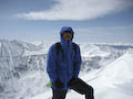
Summit Photo!
Summit register - quite impressive
The trek down Mount Sneffels is a little interesting, especially when you get to the V-notch. I descended first and then helped my dad and brother find hand and foot holds as they went through, just to be safe. When you look through the notch and see the exposure, it does funny things to you. When all three of us made it through and were back in the lavender couloir, I heard a voice from back at the V-notch and it was a gentleman hiking alone. He said, "How did you get down from here?" So, I hiked back up to help him find some hand and foot holds also. We both hiked back down into the lavender couloir and then I heard another voice from the notch. This time it was a single female hiker. The young lady asked, "Can someone help me down through here?" I once again hiked back up there to help her, wondering where she came from and why she was alone. I helped her find some holds and got her safely through the notch. After speaking briefly with her, she said her husband was down low on the mountain. I pondered why for a minute and then hiked on. Well, upon getting toward the bottom of the large gully, I saw him sitting with their dog (golden retriever) waiting for her. Upon returning, she took the dog and he then began hiking up toward the lavender couloir. Upon passing her, she stated that the dog was unwilling to go any further and so they were taking turns. I think my dad nicely told her that it was dangerous for her to hike alone, especially on a 14er with some brief class 3. We were off the mountain before her husband returned but she started down to the upper trailhead with us. She apparently felt much safer hiking near/with us. This is just a bit of an editorial on my part but she was taking a risk beyond her ability near the notch with nobody else to help her. We just happened to be there...
Anyway, we descended down the lavender couloir now on the left side (right coming up), which made it quite fun using the hand holds on the rock cliffs over to the side. Here is a picture:
Upon returning to the large gully, we slid/hiked down the scree/talus slope. Here is a video showing this endeavor:
The hike out on the 4 wheel drive road was good and no 4 wheel vehicles passed us! Even better! The clouds started to role in but it made for some great pictures:
Finally, we saw an Air Force C-130 fly over as we descended the 4 wheel drive road. What a day!
Chaplain (CPT) Witte
U.S. Army
My GPS Tracks on Google Maps (made from a .GPX file upload):
Thanks for the trip report. I'll be headed up Sneffels in a week and a half - doing the SW ridge going up, but descending the standard route. The video of the V-notch was particularly helpful.
There were a couple of guys on top when we arrived that did the SW Ridge coming up (from Blue Lakes correct?) They said it was a lot more difficult then what they bargained for. They originally planned to go down that way but then opted to go down the standard route. It's tough going down the standard route having never seen it coming up, especially the V-notch. I got the video working now of the V-notch going up. Have a good climb!
We too, parked at the lower trailhead, and enjoyed the wildflowers on the trip back down. Your Pic of V-notch is indeed helpful, as it is near the top on the left, but not at the top as expected. We might have missed it, but for a helpful hiker whose dog would not go though. It's all rocks up there, not marked. While trail may be short, it is quite steep. Anyone know the grade?
There are a couple options for exiting that upper couloir before the route that leads through the V-notch. Both pass below the notch, on what I would call the south face of Sneffels. One is maybe 1/4 of the way up the couloir, where the left wall relents enough to allow climbing it; the other is a steep gully maybe 2/3 of the way up.
Out of the couloir, terrain is pretty easy class 2-3 with lots of features to help navigate, as I recall. Some of it is visible in your photo #23, to the right of the climber. We ascended SW ridge and descended this south face route, on advice of another experienced climber we met at the summit.
Just offering this as an FYI for anyone reading the TR if you're intimidated by that notch. It does look a little dicey, especially on the descent. Congrats on a great summit!
Thanks for a great report.Thats the most accurate info I've seen about the notch.Having done it last summer, I found it to be spot on.It was very scary for me.Thanks
We saw two C-130s the same day as we were ascending Oxford from Belford. It was awesome to see those monsters flying at the same level that we were were hiking!
Caution: The information contained in this report may not be accurate and should not be the only resource used in preparation for your climb. Failure to have the necessary experience, physical conditioning, supplies or equipment can result in injury or death. 14ers.com and the author(s) of this report provide no warranties, either express or implied, that the information provided is accurate or reliable. By using the information provided, you agree to indemnify and hold harmless 14ers.com and the report author(s) with respect to any claims and demands against them, including any attorney fees and expenses. Please read the 14ers.com Safety and Disclaimer pages for more information.
Please respect private property: 14ers.com supports the rights of private landowners to determine how and by whom their land will be used. In Colorado, it is your responsibility to determine if land is private and to obtain the appropriate permission before entering the property.


")
")
")
")
")
")
")
")
")
")
")
")
")
")
")
")
")
")
")
")
")
")
 Look back down summit ridge")
 Blue Lakes from summit")
 Summit Photo!")
 Summit register - quite impressive")
")
")
")
")