Download Agreement, Release, and Acknowledgement of Risk:
You (the person requesting this file download) fully understand mountain climbing ("Activity") involves risks and dangers of serious bodily injury, including permanent disability, paralysis, and death ("Risks") and you fully accept and assume all such risks and all responsibility for losses, costs, and damages you incur as a result of your participation in this Activity.
You acknowledge that information in the file you have chosen to download may not be accurate and may contain errors. You agree to assume all risks when using this information and agree to release and discharge 14ers.com, 14ers Inc. and the author(s) of such information (collectively, the "Released Parties").
You hereby discharge the Released Parties from all damages, actions, claims and liabilities of any nature, specifically including, but not limited to, damages, actions, claims and liabilities arising from or related to the negligence of the Released Parties. You further agree to indemnify, hold harmless and defend 14ers.com, 14ers Inc. and each of the other Released Parties from and against any loss, damage, liability and expense, including costs and attorney fees, incurred by 14ers.com, 14ers Inc. or any of the other Released Parties as a result of you using information provided on the 14ers.com or 14ers Inc. websites.
You have read this agreement, fully understand its terms and intend it to be a complete and unconditional release of all liability to the greatest extent allowed by law and agree that if any portion of this agreement is held to be invalid the balance, notwithstanding, shall continue in full force and effect.
By clicking "OK" you agree to these terms. If you DO NOT agree, click "Cancel"...
Starting Point: Guanella Pass upper parking lot
Peaks in order of ascent: Square Top Mountain (13,794'), Argentine Peak (13,738'), Mount Wilcox (13,408')
RT Distance: 10.2 miles (including ~1.5 mile return slog along Guanella Pass Road)
Elevation Gain/Loss: 4,570 feet
There is something eminently satisfying about a loop trail - maybe it's the gratification of completing a journey without retracing one's path, the feeling of properly culminating an undertaking and closing the proverbial loop. My original goal was simply to climb Square Top Mountain (13,794') from Guanella Pass in what would've amounted to a short half-day hike in preparation for the tougher rigors ahead in the season. After some research and perusing many neat reports on this site, the trip gathered mass adding two neighboring 13ers, Argentine Peak (13,738') and Mount Wilcox (13,408') to the agenda. Of the reports I'd read, the recent account by SurfNTurf stuck to mind not only because it presented the loop the I wanted to do in the right sequence, but also because of Jeff's inadvertent error and the resultant warning about trespassing on private land around Naylor lake on the return segment. I knew I had two options to avoid this politically incorrect outcome - climb a fourth peak, albeit a ranked but lowly 12er - Otter Mountain (12,766') - and descend its southeast ridge until it intersected Guanella Pass road, and the other would be to descend south-east-east from Wilcox thus bypassing the lake and the surrounding private property. Both options would add some mileage and put me on unfamiliar slopes but I was ready for the challenge - after all, it's not like any of these peaks actually had trails to their summits!
The trail to Square Top starts from the upper parking lot at Guanella Pass. Square Top Mountain is hidden behind the grass-covered slope that rises gently from the trailhead.
Lovely meadow early in the hike
The trail meanders lazily through the hillside and soon part of the ridge to Square Top comes into view even though the actual summit stays hidden from view almost the entire hike.
Route to Square Top
The weather forecast called for a 50% chance of showers and thunderstorms after noon, so I took advantage of the gentle ascent and stepped my pace up to a steady run through the first couple of miles.
Trail meanders through the meadow
The main trail leads to two lakes just over 12,000' named Square Top Lakes, but these need to bypassed in order to climb Square Top Mountain.
Sharp left ahead!
In the world of 13ers, trails are not so common and so it was with this one as the trail petered out in less than half a mile of this detour, with one final sign pointing in the general direction of the grassy slope that climbs to the summit. Hikers can be spotted in the shot below, which was also somewhat unusual for these peaks.
Grassy slope
Of course, none of these hikers had quite as ambitious a mission today as I did, as their goal was limited to Square Top. My plan was to summit Square Top and continue on to Argentine without much delay. I figured I would assess the weather situation after getting to Argentine so time was now of the essence.
The hike up the tundra-laden slope was straightforward as it climbed from about 12,200' to a notch around 13,000' before making another pitch up to a false summit around 13,600'.
Tundra to the Top?
Looking down the slope
The next shot shows the relentless march up to the slope, two hikers lending perspective to the magnitude of this pitch.
Steady ascent past the notch
Hikers atop the false summit
I made it to the false summit in excellent time and the skies were still friendly as I surveyed the steep drop to the saddle with Argentine Peak, and the climb to its summit that appeared to be broken into two segments. Grays and Torreys flank the background in the next shot.
Connecting ridge to Argentine Pk
Looking to the northeast from this vantage point, I could see the distinctly shaped Naylor Lake and knew I would be skirting it on the northern border if I were successful in summiting the two other peaks on the cards.
Naylor Lake to the northeast
I didn't immediately resume the slog to the actual summit because I met a couple at this point and started chatting with them about their plans - Square Top was their only goal for the day and I found myself talking them into joining me for two more peaks and a loop finish. Now I normally would not do this, as it is easy to get caught in some else's enthusiasm when it comes to high country hiking, but they seemed to be in very good shape and we had that instant chemistry that always makes for good company. It didn't take much to convince them either and in ten minutes we were marching the final couple of hundred vertical feet to Square Top's summit en route to the ridge hike down the saddle with Argentine Peak.
Final pitch to summit
We reviewed the clouds forming in the distance to the northwest and I reinforced the strategy that we will re-assess the situation after gaining Argentine's summit whether to continue to Wilcox or retrace our paths although the elevation gain in re-summiting Square Top might negate the lower mileage of that return option.
As we embarked on the next leg, I surveyed the ridge route to both peaks; the saddle with Argentine descends to 13,000' leaving over 700 feet of elevation gain to reach its summit, while climbing a few false summits. The saddle between Argentine and Wilcox is at 12,800' and very broad, with Wilcox requiring around 600 feet of elevation gain to its high point.
One down, two to go!
The initial descent off Square Top is on steep talus which gives way to tundra making for an enjoyable hike to the saddle. This picture was taken while still descending to the saddle and shows the three lakes.
Lakes Ahoy!
Once we got to the saddle, Argentine's summit was no longer visible but the ridge route is straightforward. This ridge is marked with several rock outcroppings most of which needed to be directly climbed while some could be skirted on the right.
Ridge route to Argentine
The next shot looks back at Square Top Mountain and the ridge traverse from its broad summit - my fellow hikers can be spotted just past the saddle.
Looking back at Square Top
Bypassing rocky spurs on the ridge
After I crossed the last ar�te bypassing it to the right, there was one final push left to gain the second summit of the day.
Almost there!
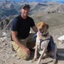
I snapped my obligatory self-portrait on the top and enjoyed the views while waiting for my friends to catch up.
Yours Truly
There didn't seem to be an immediate threat of thunderstorms so I knew Wilcox was a go. When my friends joined me on the peak, we discussed plans and decided we would climb Wilcox and then descend its southeast slopes while avoiding Naylor Lake entirely.
Two down, one more to go!
We surveyed the connecting ridge to Wilcox which is a bit more rugged than the one between the first two peaks.
Ridge route to Wilcox
The drop to the saddle is steep before the ridge levels out so we enjoyed boulder hopping through this section and traversing the broad saddle before starting the push for the final peak of the day.
Argentine-Wilcox saddle
The serrated ridge transitioned between tundra and boulders and made for a delightful traverse.
Jagged ridge to Wilcox
The next shot looks back from the final talus section well above the saddle at the broad lofty expanse of Argentine.
Looking back the ridge toward Argentine
I marched up the boulder field with renewed vigor and was soon atop the final summit of the day.
Final talus to Wilcox
The clouds were now moving directly overhead as I glanced northwest toward Grays and Torreys.
Clouds looming overhead
I was soon joined by my partners in crime and we decided to stick to our planned exit strategy of descending the grassy east slope of Wilcox. We mapped out a route that would skirt the private land surrounding Naylor Lake and eventually connect us to Guanella Pass road some 800 vertical feet below the summit where we'd parked.
As we descended down the beautiful east slopes of Wilcox, the clouds had started to build up above the peaks. I glanced up at the majestic duo of Bierstadt and Evans to the east and caught a memorable shot showcasing the rugged beauty of the sawtooth connecting these two majestic front rangers.
Bierstadt and Evans
We successfully managed to avoid Naylor Lake but did flirt with private land as we hit Naylor lake road about half a mile earlier than we'd targeted. Climbing a few cliffs on the way down was the perfect topping to a rewarding day in the mountains.
Skiting cliffs on the descent
The 1.5 mile trudge up the road was summarily dispatched as we recounted the day's highlights and how we'd escaped nature's fury with nothing more than a few drops of rain toward the end. I was barely halfway on the drive back down Guanella Pass road before the clouds unleashed their pent-up moisture in a torrent that lasted until I was well on my way on I-70. Close call indeed but some days everything just goes your way and I sure wasn't complaining!
My GPS Tracks on Google Maps (made from a .GPX file upload):
Being relatviely new to 13ers, I was somewhat frustrated when researching this route last Monday. Now there are two reports from the last six days that document every section of the loop in detail. Where was this last week?! Haha.
I did this loop today. I should have read your comments about the private property more closely as I hiked right into the cabins East of Naylor Lake. A lady let me know I was on private property, but didn't make a big deal about it when I apologized. It looks like you could do the loop and avoid the private property by heading down south toward Silver Dollar Lake after dropping about 500' off Wilcox and then picking up the USFS Silver Dollar Lake Trail which skirts the Naylor Lake Club property on the south. Or just staying north on Wilcox's East Ridge and aiming for the Silver Dollar Lake trailhead should do the trick but might require battling some willows.
...that first option sounds interesting, would definitely be worth a try.
Caution: The information contained in this report may not be accurate and should not be the only resource used in preparation for your climb. Failure to have the necessary experience, physical conditioning, supplies or equipment can result in injury or death. 14ers.com and the author(s) of this report provide no warranties, either express or implied, that the information provided is accurate or reliable. By using the information provided, you agree to indemnify and hold harmless 14ers.com and the report author(s) with respect to any claims and demands against them, including any attorney fees and expenses. Please read the 14ers.com Safety and Disclaimer pages for more information.
Please respect private property: 14ers.com supports the rights of private landowners to determine how and by whom their land will be used. In Colorado, it is your responsibility to determine if land is private and to obtain the appropriate permission before entering the property.


 Lovely meadow early in the hike")
 Route to Square Top")
 Trail meanders through the meadow")
 Sharp left ahead!")
 Grassy slope")
 Tundra to the Top?")
 Looking down the slope")
 Steady ascent past the notch")
 Hikers atop the false summit")
 Connecting ridge to Argentine Pk")
 Naylor Lake to the northeast")
 Final pitch to summit")
 One down, two to go!")
 Lakes Ahoy!")
 Ridge route to Argentine")
 Looking back at Square Top")
 Bypassing rocky spurs on the ridge")
 Almost there!")
 Yours Truly")
 Two down, one more to go!")
 Ridge route to Wilcox")
 Argentine-Wilcox saddle")
 Jagged ridge to Wilcox")
 Looking back the ridge toward Argentine")
 Final talus to Wilcox")
 Clouds looming overhead")
 Bierstadt and Evans")
 Skiting cliffs on the descent")