Download Agreement, Release, and Acknowledgement of Risk:
You (the person requesting this file download) fully understand mountain climbing ("Activity") involves risks and dangers of serious bodily injury, including permanent disability, paralysis, and death ("Risks") and you fully accept and assume all such risks and all responsibility for losses, costs, and damages you incur as a result of your participation in this Activity.
You acknowledge that information in the file you have chosen to download may not be accurate and may contain errors. You agree to assume all risks when using this information and agree to release and discharge 14ers.com, 14ers Inc. and the author(s) of such information (collectively, the "Released Parties").
You hereby discharge the Released Parties from all damages, actions, claims and liabilities of any nature, specifically including, but not limited to, damages, actions, claims and liabilities arising from or related to the negligence of the Released Parties. You further agree to indemnify, hold harmless and defend 14ers.com, 14ers Inc. and each of the other Released Parties from and against any loss, damage, liability and expense, including costs and attorney fees, incurred by 14ers.com, 14ers Inc. or any of the other Released Parties as a result of you using information provided on the 14ers.com or 14ers Inc. websites.
You have read this agreement, fully understand its terms and intend it to be a complete and unconditional release of all liability to the greatest extent allowed by law and agree that if any portion of this agreement is held to be invalid the balance, notwithstanding, shall continue in full force and effect.
By clicking "OK" you agree to these terms. If you DO NOT agree, click "Cancel"...
The aim of this trip report is to strengthen the beta about the Cottonwood approach to the Crestones. The report is geared for an over-night trip. The report describes our ascent and descent of Crestone Peak and the knowledge we gained and hope to share.
Ascent party: Stiffler_from_Denver and Exiled_Michigander
Itinerary:
Day 1: Left Cottonwood Creek Trailhead at elevation 8,400 feet at 4:30pm on Saturday and gained 2,700 and 4.7 miles to 11,100 in 3 hours and 15 minutes. Camped.
Day 2: Left camp at 4:30am, gained 3,200 feet to Crestone Peak's Summit in 4 hours. Sat on summit at 8:30am. Descended to Cottonwood Lake around 11:30 to scout out Broken Hand Pass and route on Needle. Hiked back to camp, sat in hammock, made lunch and packed out. Back at car by 5:30pm.
Things to know about Cottonwood Approach:
This is a great alternative to the standard route from South Colony Lakes because you avoid having to go over Broken Hand Pass (twice).
Many avoid this route because they think it involves a lot of bushwacking. This really isn't the case. Aside from a few fallen trees, the approach is well defined.
If you camp at 11,100 (about 3.5 hour hike from car), it involves about a 1.5 hour hike to get to the Red Gulley the next morning. The alternative is to hike into flat spots around 12,000 feet above treeline and camp to be closer to the Red Gulley. The terrain between 11,100 and 12,000 is pretty steep for adequate camping spots. So your campsite options are either below 11,100 or above 12,000. Make sure you have the legs to carry a heavy pack above 11,100, because it's at least another hour of steep climbing to get to another adequate camp site if you opt to camp above 11,100.
Bring bug spray.
The mosquitos were very annoying for the first few miles of the approach from Cottonwood trailhead.
There are some great spots by the creek with a cool waterfall about 3.5 miles in. This would be a great day hike.
Watch out for Marmots! They will chew through trekking poles and anything else left in the open above treeline. We stashed our trekking poles below the red gulley and were greeted later in the day with chewed up equipment.
To avoid climbing around the creek and tramping through willows on the approach to the Red Gulley of Crestone Peak, we opted for some class 3 scrambling to the west. You can see our approach route on the topo map in photo 1. (it's the route to the left). We tried to follow the regular trail on the descent back through the willows but ended up in some class 3 moves and willows. I recommend the open ridge to the west for the approach. (perhaps we were off trail a bit on the decent but we followed a number of cairns and still ended up route-finding, tramping in willows, and down-climbing some class 3 sections.)
The photo below traces our route. Notice that the route to the west (left on the map) was our approach and the decent was to the east (right), which was supposed to be the trail.
The next photo shows Stiffler_from_Denver in front of waterfall on the approach on day 1.
There are some steep sections with the Cottonwood approach. The next photo shows Exiled Michigander climbing up some steep sections right near the waterfall.
There are some steep boilerplate sections of the approach below 11,000 feet. The next photo shows one of those sections.
The next photo shows one of the first times you poke through treeline and can see the valley leading back to the trailhead and the town of Crestone.
We set up camp around 11,100. Here is a picture of the excellent campsite we utilized. Wish we could have had a fire.
The next morning we stayed west of the trail to do some open class 3 climbing on rocks instead of route-finding through willows. The photo below shows Stiffler_from_Denver in the early morning climbing some rocky section toward the Red Gulley.
The next photo shows Exciled Michigander on the ascent up the Red Gulley. This is a really fun and stable route. You are in an enclosed gulley the whole time with limited airy exposure. It takes about 2.5 hours of sustained class 3 climbing, but no moves with scary exposure.
The next photo shows the ridge left to the summit of Crestone Peak after you gain the Red Gulley.
This photo looks back at Stiffler_from_Denver crossing the last ridge to summit
It took us about 10 minutes to get to the summit from the top ridge of the Red Gulley.
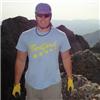
Here is Stiffler_from_Denver, Exiled Michigander, and James Dziezynski on the summit of Crestone Peak
Here is a look at the descent of the Red Gulley
It took us about 1.5 hours to slowly descent the Red Gulley.
Here is a look at the standard descent via Cottonwood Creek. Exiled Michigander poses in front of the creek sliding down the rock with the south face of Crestone Needle in the background.
Thumbnails for uploaded photos (click to open slideshow):
There is a waterfall around 12000' on the trail, just above a willow-filled field and below where things get steep. Where do you go to get around this headwall? Does the trail continue from here?
Jdorje- I think you are speaking of the waterfall that is in the last picture on the trip report. We ended up down climbing this rock (class 3). It wasn't very fun. On the ascent, however, we stayed to the left of the supposed trail. This added some more scrambling but we avoided any class 3 moves and the willow at the 12,000 part.
I have been eyeing this approach for quite some time and hoping for a good TR explaining the route. I see you provided a map of your route. By chance can you send me a .gpx file so I can put it in my GPS? Thanks, Chris
There is a high traverse past the waterfall and willows that takes you past all those annoyances into the upper basin. Look left and climb steep scree and grass to get to it.
Caution: The information contained in this report may not be accurate and should not be the only resource used in preparation for your climb. Failure to have the necessary experience, physical conditioning, supplies or equipment can result in injury or death. 14ers.com and the author(s) of this report provide no warranties, either express or implied, that the information provided is accurate or reliable. By using the information provided, you agree to indemnify and hold harmless 14ers.com and the report author(s) with respect to any claims and demands against them, including any attorney fees and expenses. Please read the 14ers.com Safety and Disclaimer pages for more information.
Please respect private property: 14ers.com supports the rights of private landowners to determine how and by whom their land will be used. In Colorado, it is your responsibility to determine if land is private and to obtain the appropriate permission before entering the property.


")
")
")
")
")
")
")
")
")
")
")
")
")