Download Agreement, Release, and Acknowledgement of Risk:
You (the person requesting this file download) fully understand mountain climbing ("Activity") involves risks and dangers of serious bodily injury, including permanent disability, paralysis, and death ("Risks") and you fully accept and assume all such risks and all responsibility for losses, costs, and damages you incur as a result of your participation in this Activity.
You acknowledge that information in the file you have chosen to download may not be accurate and may contain errors. You agree to assume all risks when using this information and agree to release and discharge 14ers.com, 14ers Inc. and the author(s) of such information (collectively, the "Released Parties").
You hereby discharge the Released Parties from all damages, actions, claims and liabilities of any nature, specifically including, but not limited to, damages, actions, claims and liabilities arising from or related to the negligence of the Released Parties. You further agree to indemnify, hold harmless and defend 14ers.com, 14ers Inc. and each of the other Released Parties from and against any loss, damage, liability and expense, including costs and attorney fees, incurred by 14ers.com, 14ers Inc. or any of the other Released Parties as a result of you using information provided on the 14ers.com or 14ers Inc. websites.
You have read this agreement, fully understand its terms and intend it to be a complete and unconditional release of all liability to the greatest extent allowed by law and agree that if any portion of this agreement is held to be invalid the balance, notwithstanding, shall continue in full force and effect.
By clicking "OK" you agree to these terms. If you DO NOT agree, click "Cancel"...
Gladstone Peak is 13,913', making it a whopping 87' shy of receiving exponentially more attention. It is the 67th highest named peak in Colorado and sits just outside Telluride, meaning it requires a long drive to even get started. It is loose, difficult, and surrounded by three 14ers, including Wilson Peak (the face of the Coors can) and one of the four Great Traverses (between Mt. Wilson and El Diente). If you are there to climb Gladstone, it is because you made it a specific target...
Boring Backstory.
Standing as the proud rhinoceros-like vanguard at the east end of Navajo Basin, Gladstone was the first peak I took in when I first visited the Wilsons for the basin's 14er trifecta. Even then, Gladstone was by far the most aesthetic of the group, although it was a puny 13er. I blanched, fully incredulous, when I saw someone in the midst of rain, hail, and snow make for Gladstone's north ridge during that first visit. The soloist's partner had opted not to join him, casually citing as cause the tremendously loose, tippy rock that persisted on the ridge (not the weather). Numerous trip reports reiterated this theme: loose, tippy, dangerous. Even the ones that did not explicitly discuss the unreliable footing--i.e., the snow climbs--emphasized snow as a means to ease passage to the summit. Combine that caveat with Gladstone's distance from Denver, and it remained hovering lower on the to-climb list than it deserved.
The time came in June 2012. Nolan and I had settled on a swing through the San Juans to explore some new peaks that appealed to us. Our itinerary called for a visit to Pigeon and Turret before capping our trip with Gladstone. Fires forced a change of plans, and after P&T we fled the smoke-choked air and returned to Denver. Gladstone would wait.
***To the firefighters, volunteers, coordinators, paramedics, and emergency personnel, thank you and stay safe. Your work is beyond compare.***
Fast forward to June 2013. For all the obvious reasons, as well as our own selfish ones, we hoped for no fires. Fortune was not with Colorado. Following a slow winter and continuing drought, fires again ignited the land. Smoke from the fires covered much of the Front Range, Sangres, lower Sawatch, and eastern San Juans. Largely spared, however, were the western San Juans. Gladstone sped up the list.
Route Planning.
Our concerns about Gladstone's loose rock remained. From the route info and reports, we distilled one common truth: the rock on the ridge's flanks was terrible, considerably more so on the western flanks. The ridge, however, appeared to offer steadier rock (context!) with a trade-off of higher difficulty in climbing. Our choice was easy: give us a solid ridge scramble over boulder-dodging any day. We would attempt to run the ridge and adapt on the fly. This promised to go smoothly.
Looking up, this is what happens if you don't stay on the ridge.
The Approach.
Bill's trailhead description here is very good. The one thing I would add is that a mile after turning onto FR 645, you come across a creek crossing (Bear Creek; we saw no bears). If you have a high clearance 4WD, you can continue through this crossing to the Rock of Ages (ROA) Trailhead (TH), which is 1.25 miles up the road. The crossing is deeper than it looks, particularly in early season and late afternoon. If in doubt, park. The hike is gentle and will go fast, and there is parking for a few cars before the crossing so long as nobody's a jerk. The road is passable for any vehicle to this point. 2WD cars face a bumpy ride for the 2.2 miles from the soft right until the turn onto FR 645, but nothing show-stopping. Once you turn onto FR 645, the road is practically smooth until the creek crossing.
The road in/out.
Do not follow Roach's driving directions. They predate the use agreement and will lead you directly into private property. They are fine until the right-turnoff for FR 645 (at which point, Roach suggests you continue straight).
The trail to the ROA saddle could not be more well-marked; signs abound. One note, however: Bill's mileage on this is juuuust a bit off. Currently it is listed at 3.7 miles roundtrip. It is more like 4.3 miles from the ROA TH to the ROA saddle. One way. There is no real opportunity to re-up on water, either.
The ROA saddle. Still a ways away.
We encountered several snow crossings before the ROA saddle that would have proved tricky in the morning without an axe, although it could be done if you were either careful or willing to climb a little out of your way.
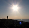
Sunrise over Wilson Peak.
From the ROA Saddle.
Once at the saddle, take in Gladstone's north ridge.
Gladstone reveals herself (from ROA saddle). Looks like a jurassic stingray from here.
There are many opportunities to gain the ridge. Most involve dropping into Navajo Basin and then scurrying up a rotten gully. Leave grace and dignity at the saddle. This is, in fact, what we did. (Scurried up gully, left dignity. Sigh.)
From the ROA saddle, we identified a short, low-angle gully that gained the ridge just north of a large, unmistakable fin. We figured that would leave us in the junk for the shortest time and get us to a superb starting point on the ridge.
The long ridge. The arrow indicates our ascent gully.
The gully was garbage and the most tedious part of the whole day.
Our ascent gully. Not recommended.
Ridge Run!
The first obstacle greeting us upon exiting our ascent gully.
Were we to do this again, we would simply follow the ROA trail up towards the ridge as though we were going to Wilson Peak. We did not do this at the time, as there appeared to be three imposing towers that could have required serious scrambling. We needn't have worried. We opted for this route on the way out, instead of putting ourselves in harm's way by descending any of the sketchy gullies (we'd heard and seen rock slides roll through these gullies all day). These towers are easily bypassed on the eastern/Bilk Basin side. Even so, they go relatively easily.
This is the route we had opted against for the ascent but opted for on the return. Looks harder than it is. Bilk Basin is o
From here, the route is essentially a ridge run. Unless you prefer ankle-bending, slide-inducing, death-defying side hilling on questionable terrain. If so, by all means, drop to the eastern side and good luck to you. There's no real way to describe every route decision we made. Instead, I'll just say most decisions were straightforward, but we had to constantly ignore the temptation of serpentine use trails on the eastern side (sure, the fruit looked delicious, but nothing good could come of that choice).
Checking out the route.
The few times we followed use paths off the ridge, we quickly encountered nasty loose slabs and crumbling slopes that required side hilling on unstable ground; we would immediately "retreat" to the ridge.
A closer look at the ridge. And if you think this looks loose....
Stay the course.
One note: as you run the ridge, TEST EVERY HOLD.
Yes, the ridge is incalculably more solid than the slopes, but that doesn't mean you can be complacent. Test it and test it again.
Progress.
Coming up.
A word about Nolan. Some people get sick at high altitude. Nolan has reverse-altitude sickness: he gets stronger the higher he climbs. The guy's a gazelle--springing from rock to rock, then just hanging out while us mere mortals grunt and heave and clamber to him.
Nolan and the Wilson-Diente Traverse.
Another note: sometime after the fin but before the ridge steepens in the final push to the summit, you cross an attention-grabbing mini-knife edge. It's not a huge deal, but some people prefer to mentally prepare for this sort of thing beforehand instead of simply stumbling upon it. It's a lot like Capitol's knife edge, with bomber holds up top and cracks for your feet on the sides.
Nolan loves knife edges.
I am just fine with knife edges.
Sorry For All the Text. Predominantly Pictures From Here.
(See heading.)
Nolan loves Gladstone's ridge run.
Guess where.
It may be tempting to try to cut corners, but cheaters never win.
And they get f---ed by loose rock.
Nolan loves Lizard Head.
Looking back at difficulties past and future. NBD. Just reverse the course.
That side hilling use trail sure looks tempting. NO.
Going up! I promise it's more stable than it looks.
It's a long way back. Or, if you're a glass-half-full type of person, "We've come a long ways! Yay!".
The summit's just in reach.
A word about the summit. Some summits have geological markers. This one has a crowbar.
The great Wilson-Diente Traverse.
After taking in the views, swatting flies, and generally enjoying an exceptional summit, we started our descent. Nothing too remarkable, just be sure to save enough energy and focus for it. Great stuff.
Plenty of down climbing. Or up climbing. The ridge undulates.
Conclusion.
The ridge option made this an immensely enjoyable day. The rock was relatively solid (again, context!), the views were spectacular, and the climbing was challenging but not absurd--all in all, greatly enjoyable.
We had been dreading this peak, and we both wound up loving it. A solid class 4(+?) ridge run makes a huge difference vis-�-vis a class 3 boulder-dodging affair. Sure, it was tiring, but in the best way. I'd do it again in a heartbeat, were it not so far away.
Gladstone. And lots of it.
Reward.
We stopped in Ridgeway at the Colorado Boy Brewery. After a sample flight and some fine, fulfilling pizzas, we hit the road.
Thanks for reading!
Thumbnails for uploaded photos (click to open slideshow):
Joseph G: Nice report. Did you happen to take advantage of the wobble on that ”grand piano-sized” flat rock near the summit? Generally safer to stay ON a ridge when doing a ridge route. Thanks for posting. Happy trails!
Great report, Joe. I really expected Gladstone N. Ridge to be a ”survived and won't press my luck by repeating” sort of route/peak. But it was actually enjoyable scrambling on mostly decent (for the Wilsons) rock. IMO, El Diente from Kilpacker (and even Mt. Wilson from Navajo) are significantly more dangerous.
@ Raj - Thanks! It was tough winnowing out some lesser-decent pics.
@ Jay - We weren't moving particularly fast for a variety of reasons (bluebird day, smoke, accumulated fatigue from several days out). I think it took about five hours ROA to ROA, including a summit stay. It could be done much faster without much effort.
@ Brian - Definitely some sketch. We both commented how our ascent gully felt like that long slope to the Ice-North Apostle saddle. Much more solid after that.
@ Presto - It's still there. We didn't do much rocking on it, save the inadvertent discovery of its whereabouts. Yeah yeah, ridges = solid...we were just curious how bad it could be.
@ Dave - They're coming along. No rush to finish 'em, just an eventual goal. Got about 15 left? They're all a long drive away.... This one's worth the drive.
@ Jed - Definitely a worthwhile day. We considered adding WP on the return, but ultimately the 6+ hour drive back to Denver looming dissuaded us from the repeat. Glad it helped!
@ ACER - We saw your trip/TR from May. Looked like a fun way to get it, and congrats to you/your team. We'd been dreading the looseness, but our route made the mountain not as bad as advertised. (We actually did a reverse of some of your group: we went up Vermilion before Gladstone!).
@ Jeff - Thanks. It's a fun mountain, so it kinda writes itself.
@ John - The Wilsons miss you and send their regards.
@ Matt - It was a constant struggle not to take ”short” cuts. Looks like you've only got a few cents left, including this fun guy. Good luck!
Describes you and Nolan. Congrats!!
I may come after you for a repeat!
I haven't heard anyone say they'd do Gladstone again in a heartbeat.
'Cept you. (( ))
This TR is da bomb (continuing on the pyrotechnic theme). It will be helpful for many. Very, very well done. ”10”
Great TR! Looking at your report, I think Gladstone is a peak best climbed with snow. Helps keep the rock cemented in place!
I was fortunate enough to join an all-star team (sgladbach, globreal, Rainier_Wolfcastle, and CONative) and do Gladstone on Memorial Day weekend from Lizard Head Pass earlier this year. It was almost entirely a snow climb from the base of Lizard Head across Bilk Basin and up the east slopes of Gladstone. Despite it's reputation, it certainly seemed far safer and easier with the snowpack all over.
Caution: The information contained in this report may not be accurate and should not be the only resource used in preparation for your climb. Failure to have the necessary experience, physical conditioning, supplies or equipment can result in injury or death. 14ers.com and the author(s) of this report provide no warranties, either express or implied, that the information provided is accurate or reliable. By using the information provided, you agree to indemnify and hold harmless 14ers.com and the report author(s) with respect to any claims and demands against them, including any attorney fees and expenses. Please read the 14ers.com Safety and Disclaimer pages for more information.
Please respect private property: 14ers.com supports the rights of private landowners to determine how and by whom their land will be used. In Colorado, it is your responsibility to determine if land is private and to obtain the appropriate permission before entering the property.


. Looks like a jurassic stingray from here.")


 It's a long scramble to the summit.")
 Looking up, this is what happens if you don't stay on the ridge.")
 The road in/out.")
 The ROA saddle. Still a ways away.")
 Sunrise over Wilson Peak.")
 Gladstone reveals herself (from ROA saddle). Looks like a jurassic stingray from here.")
 The long ridge. The arrow indicates our ascent gully.")
 Our ascent gully. Not recommended.")
 The first obstacle greeting us upon exiting our ascent gully.")
 This is the route we had opted against for the ascent but opted for on the return. Looks harder than it is. Bilk Basin is o")
 Checking out the route.")
 A closer look at the ridge. And if you think this looks loose....")
 Stay the course.")
 Progress.")
 Coming up.")
 Nolan loves Lizard Head.")
 Nolan loves knife edges.")
 I am just fine with knife edges.")
 Nolan loves Gladstone's ridge run.")
 Guess where.")
 Nolan and the Wilson-Diente Traverse.")
 Looking back at difficulties past and future. NBD. Just reverse the course.")
 That side hilling use trail sure looks tempting. NO.")
 Going up! I promise it's more stable than it looks.")
 It's a long way back. Or, if you're a glass-half-full type of person, \"We've come a long ways! Yay!\".")
 The summit's just in reach.")
 The great Wilson-Diente Traverse.")
 Plenty of down climbing. Or up climbing. The ridge undulates.")
 Gladstone. And lots of it.")
 Reward.")