Download Agreement, Release, and Acknowledgement of Risk:
You (the person requesting this file download) fully understand mountain climbing ("Activity") involves risks and dangers of serious bodily injury, including permanent disability, paralysis, and death ("Risks") and you fully accept and assume all such risks and all responsibility for losses, costs, and damages you incur as a result of your participation in this Activity.
You acknowledge that information in the file you have chosen to download may not be accurate and may contain errors. You agree to assume all risks when using this information and agree to release and discharge 14ers.com, 14ers Inc. and the author(s) of such information (collectively, the "Released Parties").
You hereby discharge the Released Parties from all damages, actions, claims and liabilities of any nature, specifically including, but not limited to, damages, actions, claims and liabilities arising from or related to the negligence of the Released Parties. You further agree to indemnify, hold harmless and defend 14ers.com, 14ers Inc. and each of the other Released Parties from and against any loss, damage, liability and expense, including costs and attorney fees, incurred by 14ers.com, 14ers Inc. or any of the other Released Parties as a result of you using information provided on the 14ers.com or 14ers Inc. websites.
You have read this agreement, fully understand its terms and intend it to be a complete and unconditional release of all liability to the greatest extent allowed by law and agree that if any portion of this agreement is held to be invalid the balance, notwithstanding, shall continue in full force and effect.
By clicking "OK" you agree to these terms. If you DO NOT agree, click "Cancel"...
June 04, 2013
~9.8 Miles, ~4,400 Gain
TH: Copper Creek TH. Rough 2WD, high clearance recommended.
Max difficulty: Minor class 3.
Saying our farewells, Ryan left me so he could return to work. I'm lucky and my wife flew into Gunnison so I made a quick excursion to go pick her up. Returning to Crested Butte a bit late, we set up camp just below the Copper Creek, Judd Falls trailhead.
Severely lacking of sleep from working night shifts all week, I decided to sleep in. I woke up at 7:30 AM and started hiking up the well established Copper Creek trail at 7:50 AM. The first few miles went quickly until I hit my first obstacle. The river. Crossing Copper Creek didn't provide any easy alternative so I took off the boots and pulled up my pant legs and crossed the frigid river.
Hiking up the Copper Creek trail.
Just after crossing the creek that drains out of Queen Basin, I left the trail and started the steep uphill bushwhack into Queen Basin. Snow started to appear around ~10,800 but I was able to avoid most of the snow by staying on the northern side of the basin.
Queen Basin.
Neat Spire.
At ~12,200, I headed up towards the west-southwest ridge of White Rock Mountain. Snow made climbing to the ridge enjoyable. Once on the ridge, the ascent was a loose class 2 talus hop to the summit where I arrived at 11:20 AM.
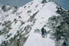
Gaining the west-southwest ridge of White Rock Mountain.
Looking up at the west-southwest ridge of White Rock Mountain.
White Benchmark from the summit of White Rock Mountain.
Descending east off the summit provided the most difficult climbing of the day with some minor class 3 scrambling around some rotten rock towers. With the snow, I was able to traverse out on the face and avoid any difficult climbing. The rock would probably be suspect without snow. Fortunately, this section was short lived. Past the rotten rock towers, I descended the southeast face of White Rock Mountain.
Rotten Rock Spires.
Looking back at the rock spires.
Once at ~12,800, I made the quick traverse over towards White Benchmark. The GPS indicated 0.15 miles and 600 gain at the base of White benchmark's northeast couloir. Looking at the top of the northeast couloir it looked steep from the basin below but as I climbed up the couloir, I learned that looks were deceiving and that exiting the couloir to the left was rather mellow.
Looking up at the northeast couloir on White Benchmark.
Climbing up the northeast couloir on White Benchmark.
The snow wasn't as firm as I would have preferred in the couloir, especially near the top. Once I exited the couloir, I encountered some minor class 3 scrambling which led me to the summit of White Benchmark where I arrived at 12:30 PM. Clouds were started to build and a cold breeze lingered so my summit stay was short.
Top of the northeast couloir on White Benchmark.
Final bit of minor scrambling on White Benchmark.
White Rock Mountain from the summit of White Benchmark.
I descended off White Benchmark's south ridge until I found easy access to a northwest couloir spur from the south ridge. Glissading went very quick back into Queen Basin where I trucked back towards Copper Creek.
Typical bushwhacking to gain Queen Basin.
Returning back to the Copper Creek trail, I made good time back to the trailhead where I arrived at 2:30 PM. I was glad to have snow cover on these peaks as they were probably more enjoyable.
Route Map.
Thumbnails for uploaded photos (click to open slideshow):
Nice couloir on White BM, Derek! I looked at that from Pearl today. You must have picked a better line than I did getting out of that notch because I ran into some exposed, loose 4th class. That is a nice area to explore.
The basin past queen offers easier travel, with no trees and deadfall to contend with, just in case anyone is heading that way. Great area, wish it had more snow this year.
Kevin - Since I was able to traverse out further left on snow from the top of the couloir, I wonder if that avoided the class 4 section. I can see my traverse to the ridge being problematic if there wasn't snow cover.
It's hard to determine from your pics, but I traversed out of that notch what would be climber's left. I think the snow did cover a lot of the garbage ledges I was on. Snow is our friend in spring! 8)
There was some sort of cliff band/Gendarme between White BM and WSC. Descending into the valley to the south should avoid any problems. Didn't look too bad.
Caution: The information contained in this report may not be accurate and should not be the only resource used in preparation for your climb. Failure to have the necessary experience, physical conditioning, supplies or equipment can result in injury or death. 14ers.com and the author(s) of this report provide no warranties, either express or implied, that the information provided is accurate or reliable. By using the information provided, you agree to indemnify and hold harmless 14ers.com and the report author(s) with respect to any claims and demands against them, including any attorney fees and expenses. Please read the 14ers.com Safety and Disclaimer pages for more information.
Please respect private property: 14ers.com supports the rights of private landowners to determine how and by whom their land will be used. In Colorado, it is your responsibility to determine if land is private and to obtain the appropriate permission before entering the property.


")
")
")
")
")
")
")
")
")
")
")
")
")
")
")