Download Agreement, Release, and Acknowledgement of Risk:
You (the person requesting this file download) fully understand mountain climbing ("Activity") involves risks and dangers of serious bodily injury, including permanent disability, paralysis, and death ("Risks") and you fully accept and assume all such risks and all responsibility for losses, costs, and damages you incur as a result of your participation in this Activity.
You acknowledge that information in the file you have chosen to download may not be accurate and may contain errors. You agree to assume all risks when using this information and agree to release and discharge 14ers.com, 14ers Inc. and the author(s) of such information (collectively, the "Released Parties").
You hereby discharge the Released Parties from all damages, actions, claims and liabilities of any nature, specifically including, but not limited to, damages, actions, claims and liabilities arising from or related to the negligence of the Released Parties. You further agree to indemnify, hold harmless and defend 14ers.com, 14ers Inc. and each of the other Released Parties from and against any loss, damage, liability and expense, including costs and attorney fees, incurred by 14ers.com, 14ers Inc. or any of the other Released Parties as a result of you using information provided on the 14ers.com or 14ers Inc. websites.
You have read this agreement, fully understand its terms and intend it to be a complete and unconditional release of all liability to the greatest extent allowed by law and agree that if any portion of this agreement is held to be invalid the balance, notwithstanding, shall continue in full force and effect.
By clicking "OK" you agree to these terms. If you DO NOT agree, click "Cancel"...
Point 13,832
Point 13,811
Grassy Mountain 12,831
Point 12,601
Red Mountain 12,826
November 17, 2012
~19.2 Miles, ~8,500 Gain
TH: Williams Creek TH (2WD, ~5-5.5 hours from Denver)
Once again, my company is short an employee in Durango but I am not too upset since I usually make a San Juan climbing trip before and after my work week in Durango. Considering my San Juan options, there weren't too many peaks with easy snow access. Mulling over modeled snow depth charts, which looked very bleak for mid November, I decided to clean up some loose ends near Lake City. I was hoping for the Stewart group but accessing the 11,000 foot trailhead felt like a gamble.
I drove to the Williams Creek trailhead Thursday afternoon and slept in my car. Unsure of the actual amount of snow, I decided to start early to account for any post-hole time. The start of the trail was relatively snow free but slowly increased as I gained altitude on the trail. Near 11,000, the shin deep post-holing began and fortunately, the south facing slopes kept the snow depth shallow until I was out of treeline.
First light on 13,811.
Around ~12,200, I departed the trail and headed for the southeast ridge of the false summit of point 13,632. More serious post-holing was encountered as I tried to gain the southeast ridge. Once on the ridge, it was an easy class 2 hike to the ridge between 13,632 and 13,832. I arrived on the summit of 13,832 at 9:00 AM. My summit stay was short and I continued on the class 2 ridge to 13,811 where I arrived at 9:55 AM.
Looking at 13,832 and 13,632.
Elk on the southeast ridge of 13,632.
Final east ridge on 13,832.
Uncompahgre and Wetterhorn from the summit of 13,832.
13,834 from the summit of 13,811.
Part of my no 12ver left behind program, I decided to add the 3 additional 12vers to the east of 13,811. I descended 13,811's east ridge and made my way towards Grassy Mountain. Due to some snow loading, I had to stay on the ridge crest the entire way which had plenty of ups and downs.
Grassy mountain from the east ridge of 13,811.
The traverse was long to Grassy Mountain from 13,811 and I arrived on the summit of Grassy at 11:15 AM. After my short visit on Grassy, I descended to the Grassy-13,811 saddle and then to the Grassy-12,601 saddle which included some energy consuming post-holing in the trees. I climbed up the class 2 talus south ridge of 12,601 and arrived on the summit at 12:20 PM. The views of Uncompahgre and Wetterhorn were outstanding.
Point 12,601 and Red Mountain from the summit of Grassy Mountain.
Grassy Mountain from the south ridge on 12,601.
Red Mountain from the summit of 12,601.
Moving toward my last objective, I descended the class 2 northeast ridge of 12,601 and then up the class 2 southwest ridge of Red Mountain. I arrived on the summit of Red Mountain at 12:50 PM, which I think was my favorite peak of the day.
Grassy and Point 13,811 from the summit of Red.
Point 12,601 from the summit of Red.
For my descent, I descended to the 12,601-Red saddle and then south down a talus gully to intercept a 4WD road. Once I hit the 4WD road, I followed the road back to Cinnamon Pass road passing a cabin. As I crossed the gate for the cabin, I noticed some pretty angry signage. Following the 4WD road was time consuming and never seemed to end. Eventually, I reached the Cinnamon Pass road and hiked my remaining mile back to my car. A long but rewarding day.
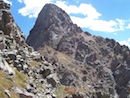
Route up 13,832 Group.
"Baldy no es Cinco" 13,313
Point 12,783
November 18, 2012
~11.2 Miles, ~3,900 Gain
TH: CDT at Spring Creek Pass (2WD, ~5-5.5 hours from Denver)
Since I had to be in Durango in the early evening for work, I decided on a shorter day. "Baldy no es Cinco" was a peak I had orphaned. Despite being orphaned, I now had the opportunity to climb 12,783 which wasn't in the original plan. The drive from Williams Creek to Spring Creek Pass was enjoyably short and I slept in my car at the top of the Spring Creek Pass.
I woke up at 4:45 AM and was surprised that a fresh � inch of snow had fallen and that snow was still continuing. Packing my gear, I started hiking at 5:20 AM. Due to the snow squall, fresh snow and very dark skies, I was unable to locate the CDT which would have taken me to the top of Snow Mesa. I started bushwhacking east towards Snow Mesa.
Snow squall in the trees on "Baldy no es Cinco."
Only a few miles away, as the crow flies, from 13,811 and 13,832, I was astonished at how much more snow I encountered. I should have brought snowshoes and I battled my way up towards Snow Mesa in knee/thigh deep snow. After yesterdays post-holing and large elevation gain day, my legs were angry. Very angry.
Near daybreak, I reached the top of Snow Mesa. Unfortunately, travel across Snow Mesa was no easy task. The fresh inch of powder snow and grass kept the snow at an energy consuming post-hole depth. Slowly, I made my way to the "Baldy es no Cinco"-Baldy Cinco saddle. Point 12,783 looked far away and I noticed a substantial amount snow that would have to be wallowed through. I took a break and refueled. From the "Baldy es no Cinco"-Baldy Cinco saddle, I headed north down snowy slopes some of which were wind loaded but nothing to be too concerned with.
First light looking west on Snow Mesa.
Neat light during a clearing on Snow Mesa.
Morning light on "Baldy es no Cinco."
Sunrise over Snow Mesa.
Looking back on Snow Mesa.
Wishing I had snowshoes, I continued across the valley to 12,783's southeast ridge. I was excited that the south slopes of 12,783 held very little snow. I enjoyed the class 2 talus hike to the summit where I arrived at 9:35 AM. I returned to the valley to the north of 12,783 and decided to climb "Baldy es no Cinco's" north ridge instead of wallowing in thigh deep snow back to the "Baldy es no Cinco"-Cinco Baldy saddle. Regaining "Baldy es no Cinco's" north ridge was no easy venture as deep powder snow and willows just angered my legs more. When I did reach the ridge, my legs were happier and travel went faster. I arrived on the summit of "Baldy es no Cinco" at 11:20 AM. The cairn on the summit of "Baldy es no Cinco" would rival the cairn on Culebra.
My descent in the valley north of 12,783.
Looking at the south slopes of 12,783.
Cinco Baldy and "Baldy es no Cinco" from the summit of 12,783.
The final summit push on the north ridge of "Baldy es no Cinco."
Large summit cairn on the summit of "Baldy es no Cinco."
Looking out over Snow Mesa from the summit of "Baldy es no Cinco."
As excited as I was to return to Snow Mesa, I had no desire to wallow my way back to the CDT trail which wasn't trail broken. The approach to these peaks via Snow Mesa is easier in the winter due to all of the snowmobiles that pack the trail! I descended "Baldy es no Cinco's" west ridge which saved me some mileage and I arrived back at my car at 12:50 PM. Without a doubt, I am going to be a bit stiff.
West ridge of "Baldy es no Cinco."
Route up "Baldy es no Cinco."
Thumbnails for uploaded photos (click to open slideshow):
Great reports! I did a similar trip this past summer (Red/Grassy, 13811/13832, and then over to Sunshine/Redcloud and finishing down Mill Creek). Loved the pics. SJ Ron
Your no 12er left behind program is impressive. When I climb 13ers and 14ers, by the time I start thinking about hitting the 12ers in the area, the thought of burgers/pizza back in town make me abandon that idea pretty quickly.
Thanks for the detailed TR. While this ridge wasn't my favorite, the views were impressive on a partly-cloudy day.
A word of caution: If the Very Angry Man is at his cabin with an axe and chainsaw, it is very hard to bushwhack around it unseen.
Caution: The information contained in this report may not be accurate and should not be the only resource used in preparation for your climb. Failure to have the necessary experience, physical conditioning, supplies or equipment can result in injury or death. 14ers.com and the author(s) of this report provide no warranties, either express or implied, that the information provided is accurate or reliable. By using the information provided, you agree to indemnify and hold harmless 14ers.com and the report author(s) with respect to any claims and demands against them, including any attorney fees and expenses. Please read the 14ers.com Safety and Disclaimer pages for more information.
Please respect private property: 14ers.com supports the rights of private landowners to determine how and by whom their land will be used. In Colorado, it is your responsibility to determine if land is private and to obtain the appropriate permission before entering the property.


")
")
")
")
")
")
")
")
")
")
")
")
")
")
")
")
")
")
")
")
")
")
")
")
")
")
")