Download Agreement, Release, and Acknowledgement of Risk:
You (the person requesting this file download) fully understand mountain climbing ("Activity") involves risks and dangers of serious bodily injury, including permanent disability, paralysis, and death ("Risks") and you fully accept and assume all such risks and all responsibility for losses, costs, and damages you incur as a result of your participation in this Activity.
You acknowledge that information in the file you have chosen to download may not be accurate and may contain errors. You agree to assume all risks when using this information and agree to release and discharge 14ers.com, 14ers Inc. and the author(s) of such information (collectively, the "Released Parties").
You hereby discharge the Released Parties from all damages, actions, claims and liabilities of any nature, specifically including, but not limited to, damages, actions, claims and liabilities arising from or related to the negligence of the Released Parties. You further agree to indemnify, hold harmless and defend 14ers.com, 14ers Inc. and each of the other Released Parties from and against any loss, damage, liability and expense, including costs and attorney fees, incurred by 14ers.com, 14ers Inc. or any of the other Released Parties as a result of you using information provided on the 14ers.com or 14ers Inc. websites.
You have read this agreement, fully understand its terms and intend it to be a complete and unconditional release of all liability to the greatest extent allowed by law and agree that if any portion of this agreement is held to be invalid the balance, notwithstanding, shall continue in full force and effect.
By clicking "OK" you agree to these terms. If you DO NOT agree, click "Cancel"...
The road that travels up to the summit of Colorado Springs' resident 14er, Pikes Peak (ne� heey-otoyoo) @ 14,115 feet would be open to bicycle travel for the first time for an extended period: the entire month of September on an exploratory basis. In the recent past, the road has only been open for one day, for a bicycle race up to the top.
This road needed to be ridden to, from Denver and summited, before the end of September came; before the road was again closed to such noble of transportation options.
But of course, that wouldn't be enough. Riding to Pikes Peak and back is something I've done before - twice in fact - once to Barr trailhead in Manitou Springs, and then hiking the Barr Trail to summit, and then back to Denver; once to try to ride unsuccessfully ride around the mountain. It would be most adventurous to link it up with another road that goes to the summit of yet another 14er: Mt Evans @ 14,265 feet. Start in Denver, ride to Pikes Peak, ride to Mt. Evans, ride back to Denver. Had anyone tried this, before?
I couldn't confirm that anyone had. If the road to one isn't open in a flexible schedule for travel by bike, it makes things difficult. To have it open for 30 days, in September - where the weather in the high parts of the state starts to turn a bit nasty, why would anyone want to? I smelled a chance for some disaster-style riding.
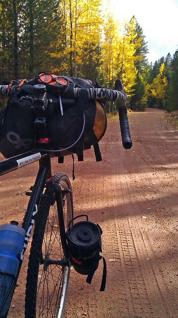
The gear would be simple, no-frills, light weight, dependable.
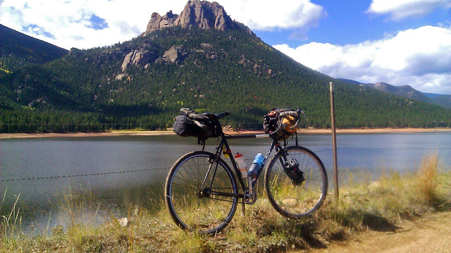
The bike: Surly Crosscheck, which I've been using for racing the cyclocross season, somewhat non-seriously. I just can't take racing all that seriously.
But, it's a frame I've ridden through 9 countries in less years. No fancy drivetrain. Just two rings up front, a 38t and a 34t and a flip flop hub dingle-cog-duo out in back - one side with a freewheel; 19t/17t courtesy of White Industries and the other side, fixed: 17t/21t, courtesy of Surly. Any simpler, and I'd be going single-speed. Want to change gears? Time to flip the bike upside-down, take out a wrench, loosen things up, move over the chain, tighten everything up, and flip 'er back over. Surely that'll get me up two of the highest paved roads in the state. The country.
The sleep system: my modified Tour Divide setup. A 20 degree down bag to replace whatever random 45 degree bag I packed. Bivvy sac, instead of a tent. Bringing along the footprint of my tent, to use as a tarp, if the weather should turn wet.
Niceties: Jet Boil stove, latched to the right leg of my fork, care of Salsa's Anything Cage. A few warmer clothes for some colder nights.
And maybe, if there's something else in the way, I'll bring along my trail running shoes. To invite a little more spontaneity.
I decided to invite Elliot along - he's been traveling around Europe for the past 3 months climbing the famous passes in the Alps. I told him the idea, the travel philosophy (light and fast, but no so fast as to not take photos) and to see if he'd like to come. He did. On the very last week we could try before the road was closed again to bikes, we started out.
To make things easy, we could have taken lighter-weight road bikes, riding on more direct roads up, and down these mountains, while staying in motels at night. But, such a path would be busy with motor vehicle traffic, not so easy on the eyes and for lack of a better word: boring; We'd be often repeating the same route in reverse to get from Pikes, back to the Denver area, and then repeat the route up and down Mt. Evans. Not for this trip. We'd sleep wherever there was enough cover to do so without being found. We'd take quieter, more interesting routes.
Highlands neighborhood, Denver, Tuesday September 25th at ~ 4:30pm. We met up, talked some nervous energy out and starting our ride towards Waterton Canyon, and the start of the Colorado Trail: a singletrack route that can take you all the way to Durango, if you'd like to. Set up camp a few miles from the beginning at, "Lenny's Rest Bench", to give ourselves a good position for the next day, where we'd try to ride all the way to the tollbooth of the Pikes Peak Highway. Camping at the Bench is a simple affair - one of the closest places from Denver you can free camp. The glow of the city is still very much visible from the end of the canyon. A nice prologue to what could be a very difficult ride. A few miles on road, a few on an isolated bike path and a few miles in the dark and mist on single track.
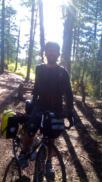
Elliott, Colorado Trail
The next morning, we took the Colorado Trail to the end of Segment 1 and in reality: the furthest I've ever gone on the Colorado Trail, even though I've toyed with the idea of seeing the trail to its end. Another time. The trail is in great shape, but our bikes aren't really the best rigs for the route. Loaded down with gear and with skinny, cyclocross tires, rather than a mountain bike with suspension, the going was at times challenging.
West Pine Creek Road
A little before lunch time, we were done with segment 1 of the Colorado Trail, and bid it farewell, taking a series of connector roads (Platte River Road -> W Pine Creek Road -> HWY 67) to the start of Rampart Range Road, a dirt road route that takes you all the way to Woodland Park and a few miles to the tollbooth of the Pikes Peak Road. At this time of year, and in the middle of the work week, it's a fairly lonely road, with only moto bike enthusiasts riding about the local trails. Woodland Park was only 60 or so miles away, but the sun starts to dip down early this time of the year and the weather was threatening while we made our way in cloudy conditions, with scattered rain clouds we oft bumped into. It also started to be obvious that I was going much faster than Elliot. I waited up every time I lost sight of Elliot. Didn't mind, but I could sense Elliot's frustration.
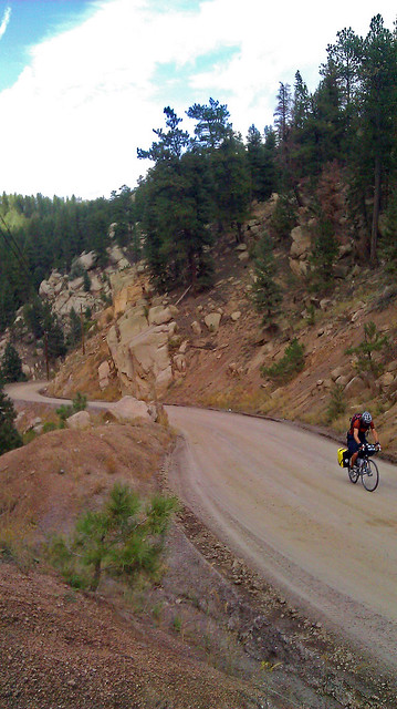
Rampart Range Road
Made it to the end of Rampart Range Road, as the sun finally went away, and the rain started in earnest. Eating dinner at what seemed to be the only restaurant open, we warmed ourselves, having dessert after dinner and, talked about camping options. Deciding to camp as close to the toll both as possible, we took on Highway 24 at night in the rain and made ourselves towards the toll both and, well, past it, making camp on top of a small rise right next to the toll both. Hoping it wasn't going to rain on us.
The next morning, we backtracked to the toll both, ditching gear nearby to save some weight and made breakfast nearby, waiting for the road to officially open. The tollboth operator offered us coffee and we all chatted. The road seemed to only be open to ~12,000 feet, which was somewhat of downer, as our first and main of two objectives might not even happen. Talking to Elliot, he was good to keep going, no matter how high we would get, so we paid our $10 and headed up.
Pikes Peak
It's a beautiful road, albeit steep. Steeper than most paved mountain routes you encounter in Colorado's mountains. My lowest, and really only gear while riding up was 34:21. Well, I guess it had to work for the next 19 miles...
About halfway up, Elliot told me it was time for me to go on ahead. The weather was obviously turning and he thought he was holding me up, going a bit slower than I, although I told him it was no big deal. But he was pretty insistent and he had a point: if the road wasn't closed to the top yet, it was going to be, pretty soon. So we made our farewells, and I wished him luck. Pedaling my little gear to the top.
The weather got bad at the last batch of switchbacks, but I didn't encounter any road closures (as if that would stop me). Just keep going, damn the weather, or the steep switchbacks, or however I was going to get down. And before I knew it, I was on top,
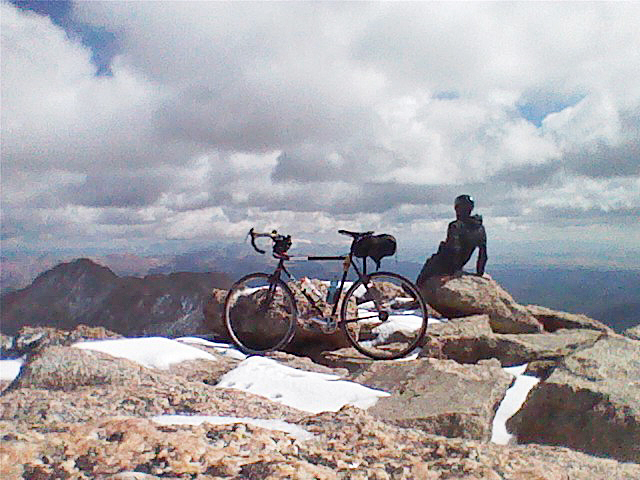
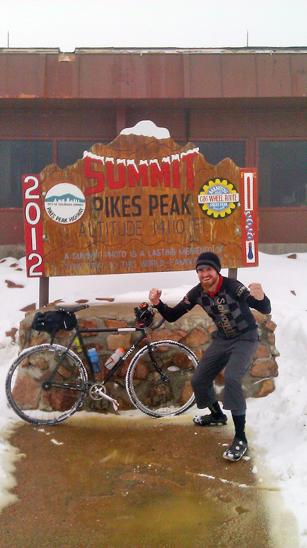
Summit, Pikes Peak
Pikes Peak has the slightly odd feature - for a 14,000+ foot mountain, of a gift shop/restaurant on the summit, and I took full advantage of their overpriced food and warm booths. As the weather got worse outside, I ate my share of cafeteria food, waiting for a break in the clouds to hurtle myself downwards. It kept snowing, as I finished my coffee. A park ranger stationed on top kept me abreast with the weather, telling me that a small system was leaving, but an even larger system was quickly advancing. The road was now closed to everyone after ~12,000 feet, I must have just made it through.
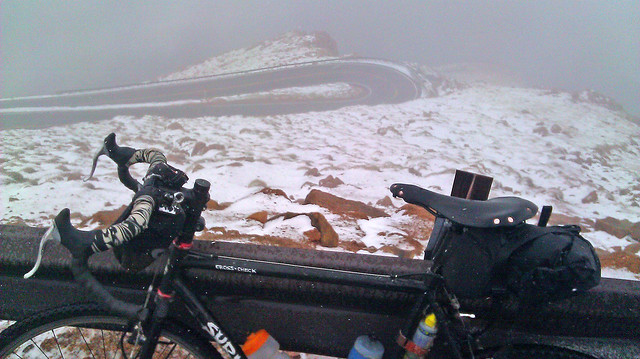
Death Switchbacks
Deciding to take my chances, in any break in between that would appear, I decided it was time to leave. The conditions were not very attractive to riding bikes down steep roads: the precipitation and cold would render rim brakes... not so useful. I changed my gearing to the highest, fixed gear I had and made my way down by carving off speed and skidding off the rest, just like being downtown, but I was definitely not downtown of anywhere. A slightly awkward affair, but no one else was on the road, it was fun, enough.
Smile.
Back near the toll both in one piece, I grabbed my cached gear, and Elliot left a note, saying he was going to bed up near Manitou Springs, to try again, later in the week. Made my way back to Woodland Park to wolf down dinner and figure out the route to the next destination: Guanella Pass. I could have gone from Woodland Park to Evergreen and from there, up to Squaw Pass, which would deliver me right to the start of the Mt Evans Highway and 13 or so miles to the top of Mt. Evans, but that'd be too easy, now, wouldn't it? Why not ride over Guanella Pass, and go around Mt. Evans from the West, continuing clockwise in a great spiral tour around the entire Evans massif, before reaching the top?
The weather cleared as I started on HW67. Perhaps six cars passed me, as I made myself to Deckers. A small tailwind, clear skies, a slight downhill route and an almost full moon accompanied me. Bidding farewell to the pavement, and turning onto Wigwam Creek Rd and back onto dirt. Bedded down for the night under one of the few remaining trees in a enormous burn area from the Hayman Fire.
The Castle, Lost Creek Wilderness
Woke up, rode for a few hours, before realizing I had made a wrong turn the night before, after ending up at a trailhead giving access to the Lost Creek Wilderness. A wonderful place to get lost. Incredible scenery, roads, terrain. Took notes from the small map of the area at the trail head, Wrote down the campsites I needed to pass, and which ones to avoid. Made it to Bailey/HWY 285 on the Colorado Trail Wilderness detour route (more Colorado Trail Race reconnoitering) alright. Ate another huge lunch and onto HW 285: busy, no shoulder and miserable. To be avoided on bike, at all costs.
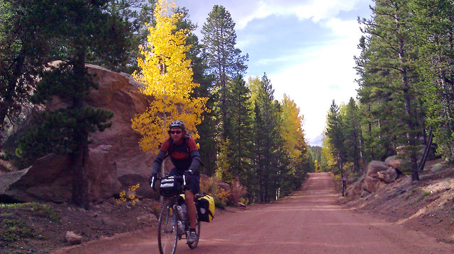
Onto Guanella Pass. Aspen leaves were exploding and the traffic of photographers trying to save the event followed. A wonderful ride; starts as a gravel road, become a nearly paved part to the top and trailhead to Squaretop Mountain (elevation: 13,794 feet) and Mt. Bierstadt (elevation: 14,065 feet). I was starting to feel the effort of this trip and was excited to reach the top of the pass, as clouds and inevitably precipitation came creeping up from the valleys, to the top of the pass. Tonight was to be a honest to goodness full moon, and it seemed worth it to gamble with staying on top, wait out whatever weather was approaching, and see if the clouds would lift, to gain the summit of Bierstadt in the middle of the night.
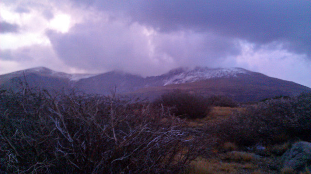
Storm over Bierstadt
It didn't look likely. Clouds enveloped me and rain - then hail began to fall. Being above treeline, there wasn't much in terms of shelter. I tied one side of my tarp to the actual trail head sign for Squaretop Mountain, and the other side to my bicycle frame and made camp right there. I didn't expect much traffic in and out. Made my dinner and my tea; set the alarm for 'round midnight and gave myself an early bed-down, as soon as the sun also gave it up for the day.
Hail yeah
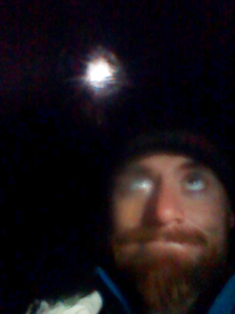
To my surprise, the midnight sky was clear enough, as the moon was bright enough to make getting up unavoidable with a proper shelter. I half expected groups of people to take on a midnight hike up the mountain, but as far as I knew, I had the mountain to myself, taking my own route up, no headlight on, and not saying a word. Summitted without fanfare, and then walked back down and went back to sleep, until sun up.
Midnight, full moon, on top of Bierstadt
Rocketed back down the north side of Guanella Pass and into Georgetown (trying not to freeze my hands off, or slip on the early-morning patches of ice), having breakfast at my favorite spot, Mountainbuzz Caf� and Pizzeria. They have never once reacted to my sorry, smelly, wind-burnt and/or rain-soaked state, any time I've collapsed into their restaurant to warm myself in front of their ovens and change out of my drenched clothing in their bathrooms. After breakfast and a costume change, I asked for a packed lunch and headed - well, not east towards Mt. Evans, but west, towards the Grays Peak Trailhead.
To me at least, it seemed silly to be so close to Grays and Torreys (elevation: 14,278 ft and 14,275 ft, respectively) and not take the quick ride up from the winter trailhead, to the summer trailhead and bag them, while I'm in the area. Make it three ascents for the day. My wonderful loneliness on Bierstadt, was harshly contrasted by the crowds on Grays/Torreys. I didn't want to do much, except hike the mountains, eat some lunch and get down to Idaho Springs for dinner, so I set myself a brisk pace and had a little walkabout up these peaks.
Looking down Dead Dog, Torreys
Thankfully, the frontage road from the trailhead, back to Idaho Springs and the start of the last leg of the trip - the final track of tremendous elevation gain and loss itself started with a gentle downhill of a few thousand feet. Ate dinner at a diner and got some supplies - batteries, candy, food for the morning, at a gas station and made my way - slowly, up the Mt. Evans Highway. My goal was to reach Echo Lake by the end of the night, and ride the last 13 miles up Mt. Evans in the morning. Slow going on exhausted legs. Every two miles - then every mile, I would stop at the mile marker itself to rest, stretch and breathe. The road is less than 5% grade, it's just that I'd been on so many grades like this in the past week and with my lack of gears and the weight of all my equipment - well, no reason to make excuses, I was just getting tired.
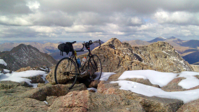
Made camp at the (closed) campsite right by the Mt. Evans tollbooth. The road itself was also officially closed, but no one's gonna stop someone on a bicycle. At around mile #5, I was greeted by three men in their 20's walking down; no backpacks, no water, no equipment - nothing. I couldn't explain it. Passed one man on a mountain bike wearing some sweats and got passed by a road cyclist that's much more serious than I was. Other than that, the mountain was all mine. From the summit parking lot, I carried the bike to the actual summit of the mountain, and took in a few views of Greys, Torreys, and Bierstadt.
Summit of Mt. Evans; Bierstadt to viewer's left, Grays/Torreys to viewers right, far in the distance
The only thing now was to take the momentous 10,000+ feet of elevation loss back to my starting point in the Highlands, and call it good. Amazingly, in less than a week, I was able to ride to, and gain the summit of all the Front Range 14ers, save Longs Peak, which would need a bit more thought, this time of season.
The question I then posed to myself: could you ride to, and then summit all the 54-odd Colorado 14ers in a single go, in a self-supported manner? It seemed likely you could, but I currently cannot find anyone that has. And if you could, could I?
My GPS Tracks on Google Maps (made from a .GPX file upload):
A classic epic adventure! If you had about 3 or 4 months, I bet you could do it. I seem to remember reading something about a guy who has done this before, but where did I see it? I bet they wouldn't let you in that pizza place in Georgetown if you concluded your journey there!
Just messin man! This is really awesome! I'm always on my cruiser taking mini adventures around Denver and have toyed around with the idea of one day biking to a TH. Thanks for the inspiration.
Now I just need a slick Surly likes yours (don't think a 500 lb bike with a 3 speed internal hub will do the trick on this one....)
Totally awesome dude. For higher points, I've biked Lincoln, Democrat, Evans, Imogene and Mosquito Pass. I love riding high elevation trails, and have my eyes set on summiting Elbert, Massive and Pikes Peak some day. Thanx for sharing.
Along about 2001, Andrew Hamilton of Boulder set the ”self-powered 14ers speed record.” He biked to all the trailheads without support (except for a couple of instances of having someone else move his bike from one TH to another) and climbed the list of 55 in under 20 days. ASFAIK, this is the only time it's ever been done. Nice work if you can get it. Go for it! (And keep us all posted.)
Pretty incredible. I've got a lot of work in the climbing gym and in the trail runnin' shoes, if this is to be taken on!
Doing it purely self supported, hauling all my gear, without a team, or bikes waiting for me on the other side of the traverse will make this a much slower affair - I'd clock it in around 60 days.
Things like the Nolan's 14 become a nightmare to plan when you have to get back to the bike eventually, that you don't have problems with while running it straight through. We'll see. I'm more for the adventure and discipline, rather than pure speed!
The last time I was on a bike as a serious cyclist was about twelve years ago and this trip report still gave me chills. Great TR! I love that last pic.
This is terrific. I love the whimsy here. You should post it on crazyguyonabike.com, which is populated more by bikecentennial and Alaska-to-Patagonia types, but people would really appreciate it. I sure did.
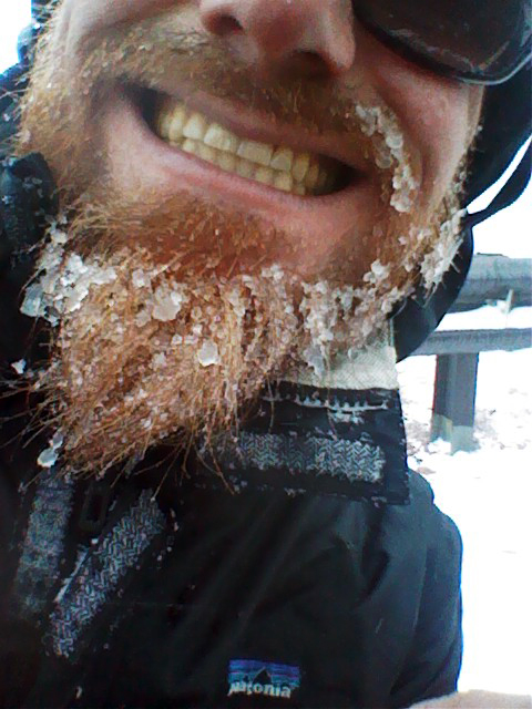
Nice trip report, I especially like the picture with all of the ice in your beard!
A couple of people mentioned my old biking trip on the 14ers...actually the first time I tried was in 2001 but I had to quit due to tendonitis. So then in 2003 I did what I called the ”Self-powered” 14ers. That is I was fully supported, only I was never allowed to get in a vehicle (or on a train), and while biking I also never drafted. That trip took just under 20 days, but is a whole different animal than a fully self supported trip, where you are carrying all of your own gear the whole way, and are therefore only on one bike, and must always return to your bike after finishing a 14er. I was always able to leave one trailhead and finish on the other side of the mountain where my bike and a nice meal would be waiting for me.
Anyway, I know that there were two guys (Pete and Glen Dunmeyer I think) who first did a fully self supported bike trip on the 14ers back in the 1980's. And then there was another guy I met named something like Roy Gibson (something like that) who did it in the 1990's. I think they were both done in about 50-60 days and none of them were going for any kind of speed record.
It would be fun to see someone go for a speed record on a fully self supported bike/hike trip of the 14ers. I think it could probably be done in 30 days or less.
Hey, Andrew! It's really cool to hear from you - your trip is def. an inspiration to me!
I'm def. getting prepped to take on the self-supported bike/hike 14er trip. I thought maybe this year would be it, but I def. didn't feel prepared enough. I whipped up a rough draft of what that may look like (as obv. I'd invite anyone else to become involved!) here:
http://tourm4.justinsimoni.com/
I'd love to chat/go hiking sometime with you if you're free sometime.
Caution: The information contained in this report may not be accurate and should not be the only resource used in preparation for your climb. Failure to have the necessary experience, physical conditioning, supplies or equipment can result in injury or death. 14ers.com and the author(s) of this report provide no warranties, either express or implied, that the information provided is accurate or reliable. By using the information provided, you agree to indemnify and hold harmless 14ers.com and the report author(s) with respect to any claims and demands against them, including any attorney fees and expenses. Please read the 14ers.com Safety and Disclaimer pages for more information.
Please respect private property: 14ers.com supports the rights of private landowners to determine how and by whom their land will be used. In Colorado, it is your responsibility to determine if land is private and to obtain the appropriate permission before entering the property.