| Peak(s): |
Longs Peak - 14,259 feet |
| Date Posted: | 08/26/2012 |
| Date Climbed: | 08/05/2012 |
| Author: | DeTour |
| Additional Members: | CharmingCatastrophe, Lucky, SikYou |
| Peak(s): |
Longs Peak - 14,259 feet |
| Date Posted: | 08/26/2012 |
| Date Climbed: | 08/05/2012 |
| Author: | DeTour |
| Additional Members: | CharmingCatastrophe, Lucky, SikYou |
| Longs Camel Route |
|---|
 Longs Peak is a classic, even by Colorado 14er standards. It has everything to make you love a mountain - physical prominence, distinctive landmarks, a vast variety of hiking/climbing conditions, incredible views, massive scale, intimidating exposure, you name it. Longs will always hold a special place in my heart, and that of my brother and daughter. It was our first 14er together in 2007. A hike that we thought would be a once-a-lifetime experience turned instead to be the beginning of a treasured family tradition. We've stood together on at least two 14er summits every year since then, fifteen in total, with no intention of stopping. Maryjane ("CharmingCatastrophe" on 14ers.com) sought out and landed a job in Denver this spring, a bold life move inspired by the mountains. This year we decided together to seek to make Longs our first repeat summit together. (Brother Mark ("Lucky") had climbed it twice in the '90s when he lived in Longmont.) To spice it up a little more, we chose a little-used variation on the standard route, the Camel gully via Chasm Lake. We were joined by Mark's stepson Brian (SikYou), who also moved to Colorado this spring, and had taken up the passion with a number of 14er summits since then. Brian and Mark snagged a prime site trailhead campsite. Despite an abundance of camping conveniences, the short night before the hike was almost sleepless for most of us. We signed the trailhead register at 2:39 a.m. We could not have asked for a more perfect weather forecast: clear skies, light winds, and zero percent chance of precipitation, even for the summit area. Dear Daughter Maryjane, who moved to Denver this spring, set a strong pace, and took way too much pleasure in repeatedly referring to her father and uncle as "flatlanders." We reached the stream crossing 55 minutes later. Once above tree line, a short distance above the stream, we switched off our headlamps and enjoyed hiking by the ample light of an almost-full moon. It was a marvelous experience, taking in nighttime views of the mountain and the lights of civilization down to the east. We would step aside occasionally to let pass other hikers who had not yet discovered the joys of moonlighting on Longs Peak. After a second hour, we stood at Chasm View, and then departed from the masses on the standard route and headed down toward Chasm Lake. I read later of people taking this route being followed by clueless hikers who intended to take the standard route but blindly followed the lights in front of them - not a problem for us, since our headlamps remained off. On the standard route, the stretch around Granite Pass to the Boulder Field is something of a slog, a long hike with little interest. But in our group on our way to Chasm Lake this morning, the anticipation was palpable. The imposing features of Longs Peak and its neighbors were clearly visible - Meeker, the Ship's Prow, and dominating all else, the Diamond. Far ahead in the distance, we saw the lights of two groups climbing the Loft route. We knew there were others ahead preparing to take on the Diamond, although lights from them were not visible. Other than that, we were alone and loving every second of it. We reached Columbine Falls in the first glow of dawn. Above the falls, the trail winds left along a stream, in a direction that is a bit counter-intuitive - we thought we would be going right. But a brief flick of the headlamp revealed a convenient Park Service sign, and we stayed on track. Someone spotted the Park Service patrol cabin not far from the trail, but our route took us in the opposite direction toward the lake. Soon we stood at the base of a small headwall in the growing light. "Bet there's a lake at the top of that," I said as we scrambled up the headwall. When we reached the top, there was no lake - just a rubble field followed by another headwall. But, when we topped out that second wall, there before us lay Chasm Lake and Longs east face in unspeakable morning beauty.  As we dropped down again from the peak of that second headwall to the edge of the lake, the sun rose through misty clouds to the east. All thoughts about pushing on toward the summit were swept away as we marveled at the beauty of the moment. Our cameras captured a tiny hint of it.  After quite some time of trying to take it all in, we realized we still had a very long way to go and began to push ahead. The magical dawn continued to sweep over us, as alpenglow bathed the Diamond with the moon above it.    That passage around the lake began with some fairly intense boulder-hopping, followed by hiking loose rubble with a semblance of a trail. Studying the Diamond as we made our way around the lake, we spotted several climbing groups. By the time we left the area, some had made their way above Broadway.     At the west end of the lake our group scattered briefly over four different route variations as we tried to locate the correct "Camel" gully - a 1,000-foot-plus climb from the lake to the ridge between Mt. Lady Washington and Longs. A distinctive rock formation at the top of the gully gives it its name, but that formation is not visible until you're about halfway up it. Identifying the correct gully to get started up was our challenge now. We relied on several trip reports for scouting this route, especially a 2008 account by flyingmagpie, who provides a huge service to the climbing community with his detailed guides to some lesser-known routes. We also had a SummitPost photo capturing the entire gully from high up on Lambs Slide, and TRs from Wentzl and Alby426. Magpie describes the Camel route as the "last" gully, with "only a cliff" behind it. That's a bit of a matter of interpretation. There is a distinctive cliff behind it, but the cliff can be skirted to climber's left (south), in front of the Diamond, and there appeared to be a plausible route above that cliff, leading into another gully. Forum friend MtnHub set out for the same route as us about two weeks before us. He ended up climbing the higher upper gully above the first cliff, not a bad accomplishment in itself. We would not read his TR until after our return. As we made our way up, Mark scrambled out ahead of the rest of us and waited perched upon a large boulder in front of what appeared to be our gully. A cliff walled off the opposite side, and the gully angled northeast up toward the saddle between Mt. Lady Washington and Longs. But when I got there, I took one look at the snowfield in the gully and said "no way." We had seen photos of this area showing a persistent snowfield at the bottom, drifted against the cliff, but then tapering away immediately at the base of the gully. This August day, we looked at a gully filled with snow/ice at the base, extending a long way up it. I thought there's no way our route could have that much snow after this year's mild winter. But Mark used the TRs and photos which he had printed in preparation for this trip to demonstrate conclusively that we were in fact at the base of the Camel Gully. We started up, MJ in the lead, following the shoulder above the snow at first.   We had heard and read criticism of this route as being full of loose rubble. (A Forest Service ranger at the trailhead the day before had tried so hard to sell the Loft route to Mark and Brian that they wondered if he was getting paid commission on it.) We didn't think it was bad. Relatively solid footing was available most of the way, if you pursued the larger boulders.  I wondered if the snow in the bottom of the gully covered some of the loosest terrain. I also came up with a theory to explain how that much snow could persist in a warm year: perhaps it's not this year's snow, but in fact was deposited in the harsher preceding winter and did not melt out last summer. As expected, the long climb took a toll on us physically. Mark and I had flown in from Chicago less than 48 hours ago. We have found Diamox to be effective in warding off the nausea and headaches of altitude sickness, but you still feel the effect, especially in your general body strength. And it's a really long climb - almost twice the elevation gain of the Trough, to put it in perspective.  But we loved it. The climbing was fun and the views unbeatable: Chasm Lake below, Lambs Slide and the Diamond behind us, and clear blue skies in front of us. The bottom half of the climb was on talus varying from basketball size to boulders. A left turn in the middle, when the Camel rock came into view above us, took us across a relatively level traverse on sand/scree below a small cliff. Beyond the cliff, we turned right and climbed up again toward the Camel on fun boulders.   We were pretty tired by the time we reached the top. After a break, we sadly bade farewell to the Diamond and Chasm View, and started across Boulder Field toward the Keyhole, clearly visible but quite some distance ahead. As we set out from that spot, we passed the higher gully that lies west of the Camel Gully. Mark peered down it and thought it looked "do-able." Turned out that's the gully MtnHub and his friend Hubie climbed a couple weeks beforehand.    At the Keyhole we joined back up with the throngs on the standard route. Passing through the Keyhole onto the Ledges had been our first true mountain experience five years ago. We wondered if, after 14 summits since then, the exposure that had slightly freaked us out the first time might not seem quite so bad this time. Sure enough, when we reached the place where the Park Service has embedded two metal stakes to help people negotiate a sloping notch, it seemed nowhere near as difficult as before.   As we traversed the Ledges, we kept scanning left to scout the route we want to take the next time we do Longs, whenever that is: The northwest couloir, a.k.a. Knight's Couloir, so named for a distinctive rock far above that resembles a knight chesspiece. Two places prior to the Knight's Couloir bore enough resemblance to the "real" one that we wondered if they might be it - but when we finally came upon the correct couloir, it was unmistakable. You cross most of the Ledges traverse before you come to the Knight's Couloir, and the chesspiece rock and four towering gendarmes to the left of the route are unmistakable. Someday we hope to be heading up that way!  But not this year. The length of the route, exacerbated by the additional vertical gain of the Camel Route, had taken its toll. All of us except Maryjane were struggling with fatigue, and we still had the long Trough and exposed final stretch to go. As we rounded the Ledges into the Trough, Brian began to lag. About a third of the way up, he called it off and declared that he was heading down. We were disappointed, but a person has to know his limits. The rest of us pushed on. The Trough was, well, the way the Trough probably always is. A variety of meandering route options, all with solid ledge-steps interspersed with loose debris, and of course a lot of human traffic. A dog-leg turn to climber's right about two-thirds of the way up makes a good goal for the flagging spirit. Just get to that turn, I told myself, and the top of the Trough will be visible - and beyond that, the short, fun, exhilarating final stretch. Soon enough, we were at and then over the chockstone at the top of the Trough. The Narrows, which had been terrifying five years ago, were still serious, and very beautiful, but nothing resembling that scary.  We headed up the Home Stretch, on rock worn slick by a gazillion human feet. The route we had taken up drove home the effect of all that traffic on the rock, because we had easily walked up similar sloping slabs back at the Camel Gully. Same mountain, same original rock conditions, completely different climbing circumstances on the Home Stretch.   The Home Stretch was also a lot longer than we remembered, as we (Mark and I anyway) struggled to overcome our bodies' limitations. We managed to stay together, and just after noon, the three of us summitted arm-in-arm, to applause from a group of cheerleaders at the top. For most of the 45 minutes or so we were on the summit, that group hung out at the point where the Home Stretch tops out at the summit, and gleefully cheered on each summiter as they reached their destination. Some purists despise the crowds on the more popular 14ers, but I never have - it's just a different experience, one you should embrace for its own special features.   The biggest challenge on the summit was to not pass out from fatigue, but to enjoy the moment and head down before the 14,259-foot air took too much toll on our exhausted bodies. We enjoyed the standard photos, our traditional Three Musketeers bar, and the inevitable summit marmot investigation of our food. The view down to Chasm Lake was extra special, having come that way a few hours earlier.   The trip down became an ordeal for me. Down-climbing the Trough, I felt like I was an accident waiting to happen, with wobbly legs refusing to go where I willed them to go. Brian's decision to turn back seemed wise to me at that point. I had been in a considerably better state than Brian when he called it off, but now I was at the very limit of my capability. A fall in the Trough would not be fatal - it's just not that steep - but it could result in serious injury, and what little strength remained would be completely sapped from a tumble. I eventually made it by simply maintaining an extremely slow pace, while Mark and Maryjane waited below. The Ledges went a little better for me, but the boulder-hopping down from the Keyhole put me back in a disastrous state. I finally regained some strength and stability when we reached the lower elevation and level trail at the campsite area in the middle of Boulder Field. Fortunately, the weather forecast proved accurate and we stayed dry even as the afternoon dragged on. Below Granite Pass, we found and used the Jim's Grove shortcut, aided again by TR research, and also by a helpful couple we encountered just above the turnoff. That route doesn't save much, but it's a little shorter, and different. Unfortunately, we were too wiped out to take any photos to help anyone else locate it. (Magpie's description of two rocks which look like whales marking the turnoff is spot on.) It was Mark's turn to suffer bodily failure on the hike out, as he struggled mightily over the final mile or so. We finally dragged ourselves out to the trailhead parking lot at about 7:20. The round trip had taken Mark and me 16 � hours - Maryjane about a half-hour less. We were relieved and delighted to see Brian with his car in the parking lot, sparing us the 200 yards or so additional hike to our campsite! Leaving Longs Peak was like saying goodbye to an old friend. We look forward to returning again in another five years or so, after the memory of the death march out fades. Note to self if I read this then in preparation for another return: take more than 48 hours to acclimate next time.  Thumbnails for uploaded photos (click to open slideshow):  Chasm Lake, 6:39 a.m.")
 First view of Chasm Lake and its magnificant backdrop")
")
")
 They aren't visible in this photo, but climbers could be seen on the Diamond when this was taken")
 Moonset over the Diamond")
 A hint of trail on the traverse around Chasm Lake")
 A sight worth stopping and staring at")
")
 Sunrise over Chasm Lake")
")
 Looking up the Camel Gully from near the top of the snowfield")
 Down the gully from approximately same location as the previous photo")
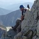
 Brian working his way up")
 Lamb's Slide")
 Keyhole from a slightly different angle than usual")
 Brian with the lake as backdrop")
 Better view of whence we came")
 Boulder field is humongous")
 \"I LOVE THIS PLACE\"")
 Crux of the Ledges - not so hard this time")
 Brian and Mark coming through the narrow spot")
 Pillars above me mark the Northwest Couloir")
 Homestretch")
")
")
 Narrows")
 Chasm Lake from the summit. We came that way!")
 Summit marmot studying the nutrition label on MJ's tuna")
 Loft and Meeker")
|
| Comments or Questions | |||||||||
|---|---|---|---|---|---|---|---|---|---|
|
Caution: The information contained in this report may not be accurate and should not be the only resource used in preparation for your climb. Failure to have the necessary experience, physical conditioning, supplies or equipment can result in injury or death. 14ers.com and the author(s) of this report provide no warranties, either express or implied, that the information provided is accurate or reliable. By using the information provided, you agree to indemnify and hold harmless 14ers.com and the report author(s) with respect to any claims and demands against them, including any attorney fees and expenses. Please read the 14ers.com Safety and Disclaimer pages for more information.