Download Agreement, Release, and Acknowledgement of Risk:
You (the person requesting this file download) fully understand mountain climbing ("Activity") involves risks and dangers of serious bodily injury, including permanent disability, paralysis, and death ("Risks") and you fully accept and assume all such risks and all responsibility for losses, costs, and damages you incur as a result of your participation in this Activity.
You acknowledge that information in the file you have chosen to download may not be accurate and may contain errors. You agree to assume all risks when using this information and agree to release and discharge 14ers.com, 14ers Inc. and the author(s) of such information (collectively, the "Released Parties").
You hereby discharge the Released Parties from all damages, actions, claims and liabilities of any nature, specifically including, but not limited to, damages, actions, claims and liabilities arising from or related to the negligence of the Released Parties. You further agree to indemnify, hold harmless and defend 14ers.com, 14ers Inc. and each of the other Released Parties from and against any loss, damage, liability and expense, including costs and attorney fees, incurred by 14ers.com, 14ers Inc. or any of the other Released Parties as a result of you using information provided on the 14ers.com or 14ers Inc. websites.
You have read this agreement, fully understand its terms and intend it to be a complete and unconditional release of all liability to the greatest extent allowed by law and agree that if any portion of this agreement is held to be invalid the balance, notwithstanding, shall continue in full force and effect.
By clicking "OK" you agree to these terms. If you DO NOT agree, click "Cancel"...
I flew out to Denver last Monday to visit the University of Denver's grad program in GIS. After that I got a rental car and drove around Colorado for a week to see some places I hadn't seen before and, of course, climb some mountains!
My first peak was Pacific Peak (13950) just south of Breckenridge. I had originally planned to do Massive but the weather didn't look too good. The climb up Pacific is pretty straightforward. There is a good trail from the parking lot off of spruce creek road up to the Mohawk lakes. 2wd vehicles can easily make it to the parking lot, I was driving a Chevy Aveo.
Once you get into the basin you can see Pacific's distinct summit off in the distance to the west. to ascend the ridge leading to the summit, you must ascend a steep and very loose gully. Since I'm from VA and only been at altitude for 3 days, this really kicked my butt...
Once you reach the plateau, its an easy class 2 scramble up to the summit. The views were rather lack-luster because of the haze, I could see Democrat peak but that was about as far as I could see.
I made it up in about 3 hours and my GPS said it was 5 miles one way. Since the views weren't that great and I wasn't feeling to fresh I decided not to traverse to Atlantic.
Peak #2: Buckskin BM
I had never been to Aspen or the Elk range, so I decided to do Buckskin BM in the Maroon Bells Snowmass Wilderness. I took the bus up at 9am (the earliest they run, if you want an earlier start, you can drive up for $10) and started hiking at 9:30 after taking the classic Maroon Bells photo. To reach Buckskin BM, take the well marked trail up to Crater Lake then head north on a good trail to Buckskin Pass.
I hiked this mid-week and there were many people on the trail. This area affords great views of Pyramid's massif and North Maroon Peak. The climb up to Buckskin Pass isn't difficult thanks to switchbacks. I reached the pass in 2 hours. The weather looked good so I went ahead and went up to Buckskin BM. Leave the trail and contour around a small hill, then descend a small rocky slope then ascend a very steep grassy slope. Towards the top it is class 2+. Buckskin BM is just under a mile from the top of Buckskin Pass. The views of Snowmass are better from the top than they are from the Pass. Descended fairly quickly because of an impending storm.
Peaks 3-5: Redcloud, Sunshine, Sundog
I was new to the San Juans as well and decided to hike Redcloud and Sunshine, and possibly Sundog if the weather held. A note on the road up to the Silver Creek/Grizzly Gulch trailhead: I did it in a Chevy Aveo with good clearance, however there are some very sketchy parts. 4wd drive is unnecessary up the trailhead but good clearance is a must. I camped out and got on the trail at 6:30 the next morning.
Despite feeling awful (breakfast hadn't settled) the ascent up Redcloud was fairly easy. There is a good trail the whole way, with a small class 2 section near the summit. Reached the top in 2 hours, snapped a summit pic then headed on over to Sunshine. Took my sweet time and took in the incredible views of the San Juans; Uncompahgre and Wetterhorn are very easy to spot. Reached Sunshine and chatted with a fella named John for awhile then decided to go for Sundog.
The northwest slope of Sunshine has a faint trail down it, which I followed. You'll reach a saddle and the ridge climb up to Sundog is in plain view. It is fun class 2+ with an occasional class 3 move. The rock on Sundog is particularly red. Descending Sundog isn't too much fun, it is very loose talus and scree the whole way down, and once you get into the trees it isn't too much fun either. There is a faint trail down, but I rarely stayed on its path. Reached the Silver Creek trail and kicked it on home and got back to camp at 12:30.
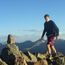
Sundog's ridge
Despite all the haze, this trip was fantastic.
Thumbnails for uploaded photos (click to open slideshow):
There used to be a tree(s) between Sundawg and Sunshine at approx 13,300'. So far it is the highest tree I have seen in the US... was curious if it was still there?
I don't remember any trees between Sundog and Sunshine, although just north of Sundog and at ~12000 ft. there were a few evergreens.
Caution: The information contained in this report may not be accurate and should not be the only resource used in preparation for your climb. Failure to have the necessary experience, physical conditioning, supplies or equipment can result in injury or death. 14ers.com and the author(s) of this report provide no warranties, either express or implied, that the information provided is accurate or reliable. By using the information provided, you agree to indemnify and hold harmless 14ers.com and the report author(s) with respect to any claims and demands against them, including any attorney fees and expenses. Please read the 14ers.com Safety and Disclaimer pages for more information.
Please respect private property: 14ers.com supports the rights of private landowners to determine how and by whom their land will be used. In Colorado, it is your responsibility to determine if land is private and to obtain the appropriate permission before entering the property.


")
")
")
")
")
")
")