Download Agreement, Release, and Acknowledgement of Risk:
You (the person requesting this file download) fully understand mountain climbing ("Activity") involves risks and dangers of serious bodily injury, including permanent disability, paralysis, and death ("Risks") and you fully accept and assume all such risks and all responsibility for losses, costs, and damages you incur as a result of your participation in this Activity.
You acknowledge that information in the file you have chosen to download may not be accurate and may contain errors. You agree to assume all risks when using this information and agree to release and discharge 14ers.com, 14ers Inc. and the author(s) of such information (collectively, the "Released Parties").
You hereby discharge the Released Parties from all damages, actions, claims and liabilities of any nature, specifically including, but not limited to, damages, actions, claims and liabilities arising from or related to the negligence of the Released Parties. You further agree to indemnify, hold harmless and defend 14ers.com, 14ers Inc. and each of the other Released Parties from and against any loss, damage, liability and expense, including costs and attorney fees, incurred by 14ers.com, 14ers Inc. or any of the other Released Parties as a result of you using information provided on the 14ers.com or 14ers Inc. websites.
You have read this agreement, fully understand its terms and intend it to be a complete and unconditional release of all liability to the greatest extent allowed by law and agree that if any portion of this agreement is held to be invalid the balance, notwithstanding, shall continue in full force and effect.
By clicking "OK" you agree to these terms. If you DO NOT agree, click "Cancel"...
The Belford Group from Rockdale (and some Extra Credit)
The Belford Group from Rockdale - July 29, 2012
Peaks (in order):
-Missouri
-Belford
-Oxford
TH: Rockdale Distance: 13 miles Elevation gain: 7,500 ft
Andrew, Shannon and I opted to head up Missouri from Rockdale rather than take the standard route through Missouri Gulch.
Pro's and Con's:
Advantage: You get to ford 2 stream crossings in your vehicle! Less (zero) people until you hit the summit of Belford.
Disadvantage: You almost have to re-ascend Missouri using its standard route to get home.
Advantage: If you go all the way back to the summit of MO, you get 2 checkmarks for Missouri?!?!? (c'mon its not even the same route...!)
Our route in red
Here goes...
We left the jeep at the gate at about 11K. Soon after, we passed Chloskey Lake and its waterfalls.
The ascent up to the Missouri ridge is short, about 2 miles, but you gain about 3,000 ft.
Prior to the day Shannon had summited 8 14ers. She had no issues leading the way, keeping up, making fun of my beard, etc. You name it, she held her own, Nice job Shannon! She should have a 14er's screename by the time this TR goes up.
on Missouri's ridge, summit in the distance, with the saddle to Iowa on the right
Class 5.16zfgsh
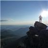
Andrew on the Summit of Mount Missouri - Elevation 14,067
On the summit we sill hadn't decided if we would descend Missouri to the south into Missouri Basin and then somewhat reascend Elkhead Pass or, keep it simple, and head down using the standard route into Missouri Gulch. After some brainstorming (and some pop tarts), we chose the southern descent and opted for the standard route back up Missouri on our return.
Andrew and Shannon heading into the basin.
A look up at Elkhead Pass from inside Missouri Basin. Belford's summit can be seen way in the distance to the left.
A look back at Missouri on our trek towards Belford. Picture taken after re-ascending Elkhead Pass.
Shannon leading the charge to Belford. She's a Fenanimal?!?!
Summit of Mount Belford - Elevation 14,197 - July 29, 2012
the route over to Oxford
a look back at Belford from the summit of Oxford. Missouri can be seen over the ridge.
Summit of Mount Oxford - Elevation 14,153 - July 29, 2012
From here we backtracked over to the Belford ridge and then back down to Elkhead Pass. We then decended north into Missouri Gulch to the the intersection where you would begin your ascent of Missouri if taking the standard route.
At the time I though he had eaten my sunglasses. He's extremely lucky I found them.
the intersection in MO Gulch where we began our re-ascent of Missouri.
I figured if you were going to make me re-ascend a mountain to 13,700 ft from a different route, I had to go all the way up to the summit again. This is me on my re-descent from my re-ascent of Missouri. Say that sentence 10 times.
Headed back down Missouri's west ridge. Long day. Great route. Great climbing partners.
The fun on this route doesn't really end when you get back to the car. This 4WD road back to Rockdale is the real deal. Enjoy it!
At the river crossing...
Andrew it was awesome to finally get back out there with you again. Had been way too long. Lets do it again soon man!
The End
Extra Credit:
Mount Democrat - July 28, 2012: The day before, I trekked up Mount Democrat with a friend from back east, Lori McGarry. This would be Lori's 1st 14er. CONGRATS LORI! Come back soon!
only a few 1000 people or so on this route today. Lori's 1st 14er! Summit of Mount Democrat - July 28, 2012 Summit of Mount Democrat - Elevation 14,148 - July 28, 2012
Extra Extra Credit
Mount Evans - July 28, 2012 (by car) - Who knew Mount Evans is the scariest mountain of all time...
Funnel cloud on Evans BRRRRRRR - really? its JULY!
Thumbnails for uploaded photos (click to open slideshow):
”Andrew, Shannon and I opted to head up Missouri from Rockdale, rather than take the standard route through Missouri Gulch”
Best decision you ever made (except for the beard). If you don't have that master(fur)piece in full effect two weeks from now I'll teach Miles to kick you in the ”Sarnelli's”.
That damn bearded guy just kept jumping into my pictures, sorry about that...
Darin - you and Ryan (monster5) both have no love for the timestamps. I include them in the TR's to give some perspective of time. The less I have to think, the better!, but I can definitely see how they take away from the pics. Maybe I'll change it up on the next one.
Dan - I'm very afraid of what Miles is going to do to me. FYI - next week, to ”dislike” is to ”dislike like dislike” which is actually a dislike. Way to be a step ahead, keep the edge!
Rob - this route is only possible if you can find the Sawatch, Mosquito, Front Range, Dales, Eliot Street Traverse. See page 377 in Roach's book.
let the international fame begin! ;) 7/31/2012 7:03am
wow, Dillon, you are a master trip-tracker! had a blast hiking with you and Andrew. thanks for the pics and kind words and excellent photo choice to start off the TR
What does that traverse go at? Can you stay ridge proper the whole way? May have to give it a try if I can figure out how to add in the Deviant Arete Direct. Nice work.
Now I am really curious, I really want to hike Missouri from Rockdale but have not been convinced I can make it up the road yet with my Dodge Nitro ”safely” more concerning safety of my car. What are the big obsticles? Is it mainly the creek crossings or are there other dangers such as ”jaws” or rocks so to speak? I've been most of the way up Mt. Princeton's road ok and the next worse was probably just the main Gray's and Torrey's road. However, I was hoping to make it up this road to the gate with my Nitro. Would appreciate your comment. I'm not new to 4WD roads, just want to be prepared to ask a jeep/truck owner to drive or if I could make it safely.
was it pretty close to the Missouri Mountain/Elkhead Pass sign? If so, that is the same little poser that we did a photo shoot with in June...that hairy little bugger knows how to work it for the camera!
Weather foiled our trifecta so I'm going back tomorrow for Missouri. I'm going solo and my only concern is the crux. Is that your ”Class 5.16zfgsh” photo? Is it do-able solo or is a partner needed to push your butt back up?
Caution: The information contained in this report may not be accurate and should not be the only resource used in preparation for your climb. Failure to have the necessary experience, physical conditioning, supplies or equipment can result in injury or death. 14ers.com and the author(s) of this report provide no warranties, either express or implied, that the information provided is accurate or reliable. By using the information provided, you agree to indemnify and hold harmless 14ers.com and the report author(s) with respect to any claims and demands against them, including any attorney fees and expenses. Please read the 14ers.com Safety and Disclaimer pages for more information.
Please respect private property: 14ers.com supports the rights of private landowners to determine how and by whom their land will be used. In Colorado, it is your responsibility to determine if land is private and to obtain the appropriate permission before entering the property.


")
 Our route in red")
")
 on Missouri's ridge, summit in the distance, with the saddle to Iowa on the right")
 Class 5.16zfgsh")
 Andrew on the Summit of Mount Missouri - Elevation 14,067")
")
 A look back at Missouri on our trek towards Belford. Picture taken after re-ascending Elkhead Pass.")
 Summit of Mount Belford - Elevation 14,197 - July 29, 2012")
 the route over to Oxford")
 a look back at Belford from the summit of Oxford. Missouri can be seen over the ridge.")
 the intersection in MO Gulch where we began our re-ascent of Missouri.")
 At the river crossing...")
 only a few 1000 people or so on this route today.")
 Lori's 1st 14er! Summit of Mount Democrat - July 28, 2012")
 Summit of Mount Democrat - Elevation 14,148 - July 28, 2012")
 Funnel cloud on Evans")
 BRRRRRRR - really?")
 its JULY!")